Nellie Juan Glacier (NJ) and Contact Glacier (C) in 1986 and 2020 Landsat images. Red arrow is the 1986 terminus location of both glaciers. Yellow arrow marks the terminus location in 2020 after glacier separation and purple dots mark the upper limit of Contact glacier at that time.
Nellie Juan Glacier is a tidewater outlet glacier of the Sargent Icefield, Alaska. Just after 1935 the glacier retreated from moraine shoal into deeper water of the fjord leading to a rapid calving retreat of 2250 m from 1950-2000, a rate of ~45 m/year (Barclay et al 2003). The rate of retreat increased to ~124 m/year from 2006-2018 (Maraldo, 2020). Harbor seals enjoy Port Nellie Juan and the icebergs from the glacier, with a population of ~44,000 identified in 2019 for the greater Prince William Sound region. From 1950-2018 Port Nellie Juan was fed in part by the Contact Glacier, a tributary that also had a separate terminus. Here we examine the changes of Nellie Juan and Contact Glacier using Landsat imagery from 1986-2020.
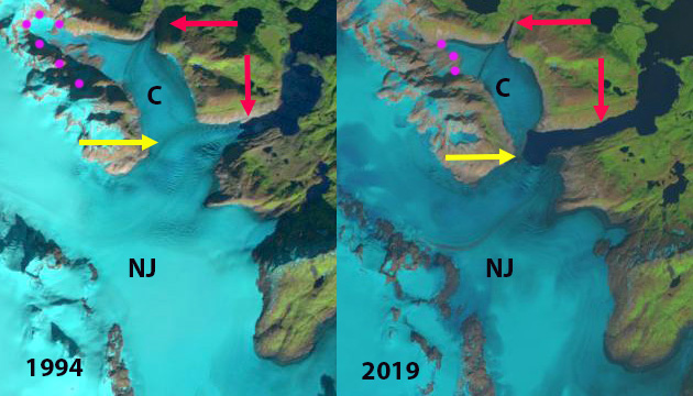
In 1986 the glacier terminated in a 0.5-km-wide calving front 1 km down fjord from the junction with Contact Glacier, which was 2 km wide. The snowline is at 500 m, the upper margin of Contact Glacier is indicated by purple dots and ranges from 400-500 m. The retreat by 1994 is ~300 m, the snowline is at 500 m and Contact Glacier has almost no snowcover. In 2000 the connection with Contact Glacier is 1.9 km wide. By 2018 terminus retreat in the center of Nellie Juan Glacier since 1986 is 2500 m. There is fringing connection of ice 300 m wide with Contact Glacier. Contact Glacier upper margin is now at 250 m, resulting in a more rapid retreat of the head of the glacier on the northern arm 1800 m since 1986, than that of the main terminus of Contact Glacier of 500 m. The snowline in 2018 is at 900 m, leaving the primary accumulation zone of Nellie Juan Glacier without snowcover. In 2019 there is still a narrow connection between Nellie Juan and Contact Glacier. In 2020 the two glaciers have separated. Contact Glacier, which had an area of 6.5 km2 in 1986, in 2020 has an area of 3.5 km2. Contact Glacier has lacked an accumulation zone during most years in this period and cannot be sustained. Nellie Juan Glacier has retreated 2800 m along the former centerline and what is now its northern margin since 1986. In 2020 the main accumulation area of Nellie Juan Glacier is again without snowcover, with a snowline above 900 m.
The glacier is terminating near a region of prominent crevassing indicating a bedrock step that may mark the head of the fjord. This will lead to an end to calving retreat and iceberg production, which will impact harbor seal haul out in the fjord (Jansen et al 2015). The retreat of Nellie Juan is less extensive than at Excelsior Glacier or Ellsworth Glacier draining the south side of the icefield. The percent loss in area of Contact Glacier is greater than other regional examples.
Nellie Juan Glacier (NJ) and Contact Glacier (C) in 1994 and 2019 Landsat images. Red arrow is the 1986 terminus location of both glaciers. Yellow arrow marks the terminus location in 2020 after glacier separation and purple dots mark the upper limit of Contact glacier at that time. In 2019 the glaciers are still connected. 
Nellie Juan Glacier (NJ) and Contact Glacier (C) in 2000 and 2018 Landsat images. Red arrow is the 1986 terminus location of both glaciers. Yellow arrow marks the terminus location in 2020 after glacier separation and purple dots mark the upper limit of Contact glacier at that time. In 2018 the glaciers are still connected


The ESRI wayback app provides a nice set of publicly accessible highres (DigitalGlobe) images, including one of this site from July 22, 2020 – looks the last vestiges of connecting ice are cut gone by then:
https://livingatlas.arcgis.com/wayback/?active=1049&ext=-148.47186,60.43178,-148.35770,60.46806