Neumayer Glacier, South Georgia, 5.6 km retreat 1999-2016


neumayer 2016

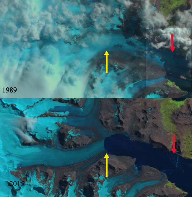
Comparison of Neumayer Glacier in 1999 and 2016 Landsat images; red arrow indicates 1999 terminus locations, yellow arrows 2016 terminus locations. Purple arrows indicate upglacier thinning.

South Georgia sits amidst the circum Antarctic westerlies and its maritime climate leads to numerous glaciers. This region is famous for the endless march of storms parading around Antarctica . The island is south of the Antarctic Convergence, preventing any truly warm season from persisting. The cool glaciers covering a majority of the island and quite low equilibrium line altitudes. Neumayer Glacier is one of the largest tidewater glaciers on South Georgia. Sugden, Clapperton and Pelto (1989) noted the ELA of Neumayer Glacier at 550 m.

The BAS has a mapping function that provides glacier front positions since early in the 20th century. For Neumayer Glacier the 1938 position is 3.5 km down fjord from the 2006 position. There was essentially no retreat up to 1974 and limited retreat up to 1993. Gordon et al., (2008) observed that larger tidewater and sea-calving valley and outlet glaciers generally remained in relatively advanced positions until the 1980s. After 1980 most glaciers receded; some of these retreats have been dramatic.

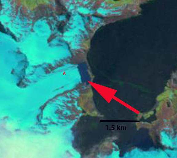
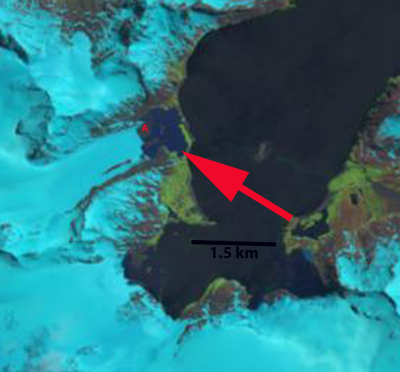
Landsat Images from 1999 to 2016 indicates retreat of 5600 m from the red to the yellow arrow, this is 350 m/year. A glacier dammed lake along the north shore of the fjord no longer exists in 2016. The glacier appears to have retreated into a deeper section of the fjord then where it ended from 1970-2002. The glacier is on the verge of separation into two main tributaries. This will enhance calving from the glacier, and promote additional mass loss and retreat. This retreat will impact Konig Glacier to the north, which is connected to the Neumayer Glacier. Below the comparison of terminus location from 1989 to 2015 indicates a retreat of 6700 m.  NASA Earth has piggy backed on this assessment, with excellent recent imagery. Calving rate increases with water depth.  Calving rate increases with water depth and the degree of glacier flotation. Flotation depends on water depth, ice thickness and the number of pinning points. Pelto and Warren (1991) provided an expanded version of the water depth/calving relationship first quantified by Brown and others (1982). In the you would have never guessed it category, is the glacier retreat has been an aid to the rat population, as the glacier tongues used to corner populations.

BAS Glacier front map

neumayer compare

Comparison of Neumayer Glacier in 1989 and 2015 Landsat images; red arrow indicates 1989 terminus locations, yellow arrows 2015 terminus locations.


Purvis Glacier Retreat, South Georgia Island

Purvis Glacier is on the norteastern coast of the island, terminating on land near Possession Bay. The British Antarctic Survey (BAS) has mapped many aspects of the island including glacier front changes. Their mapping indicated below shows that the Purvis Glacier terminus was on the coastline in 1974. Here we examine Landsat imagery from 1999 to 2014 to identify more recent changes. Cook et al (2010) quantified the change in these maps noting that 97% of the 102 coastal glacier retreated between the 1950’s and today.
purvis glacier map
BAS map of Glacier change.

purvis ge
Google Earth image

In 1999 the proglacial lake, red arrow, that the glacier terminated in was 300 m wide, indicating a retreat of 300-400 m since 1974. By 2002 the proglacial lake had expanded to a width of 600 m, exposing a peninsula at Point A. By 2013 the proglacial lake had expanded to 1050 m, further exposing the peninsula at Point A. By March 1, 2014 Landsat imagery indicates a retreat of 1100 m since 1974, with most of that retreat occurring since 1979. A closer look at the glacier from Google Earth highlights the issue. The glacier is fed by relatively low lying snowfields with quite limited areas above 500 m. Sugden, Clapperton and I in a 1989 paper identified the snowline a short distance from here at 400 to 450 m. As the 2011 Google Earth image indicates the remaining snowcover at the end of the melt season is minimal, too little to sustain this glacier (Pelto, 2010). Further a look at the terminus indicates the stagnant nature of the terminus region that will lead to continued retreat, blue arrows note ablation holes in the glacier that do not develop when a glacier is actively moving. The low slope and stagnant nature should preserve an excellent glacial geologic landscape.

The glacier is behaving in the same fashion as other land terminating glaciers Heaney Glacier and Konig Glacier. The retreat is less than that of calving glaciers on the island Neumayer Glacier and Ross-Hindle Glacier.
purvis glacier 1999
1999 Landsat image

purvis glacier 2002
2002 Landsat image

purvis glacier 2013
2013 Landsat image

purvis glacier 2014
2014 Landsat image

purvis glacier terminus
Google Earth image

Herz Glacier Retreat, South Georgia

Herz Glacier is on the southeast coast of South Georgia Island. The terminus change of this tidewater glacier ending in Iris Bay was completed by the British Antarctic Survey for the 1960-2007 period (Gordon et al, 2008). The map below indicates the slow retreat from 1960-1988 and a more rapid retreat since.harz glacier map Here we examine imagery from Google Earth and Landsat to examine terminus change from 1989-2010. In each image the red arrow indicates the location of the terminus in 2009-2010 the yellow arrow the 1989 terminus position. The first image is the Google Earth image from 2010, followed by the 1989, 2000 and 2009 Landsat images. The terminus on the north side of the fjord has retreated 1.8 km in the 20 year period and the terminus on the south side has retreat 2.2 km. The overall 2 km retreat is a rate of 100 meters/year and is 20 % of the total glacier length. This is an exceedingly cloudy region and imagery from 2011 and 2012 does not provide a clear observation of the terminus. The retreat of this glacier is less dramatic than that of Neumayer Glacier or Ross Hindle Glacier further north on the coast.herz glacier ge

harz glacier 1989

harz glacier 2000

harz glacier 2009