Norrearm Fjord Glacier Retreat, Greenland

norrearm-compare

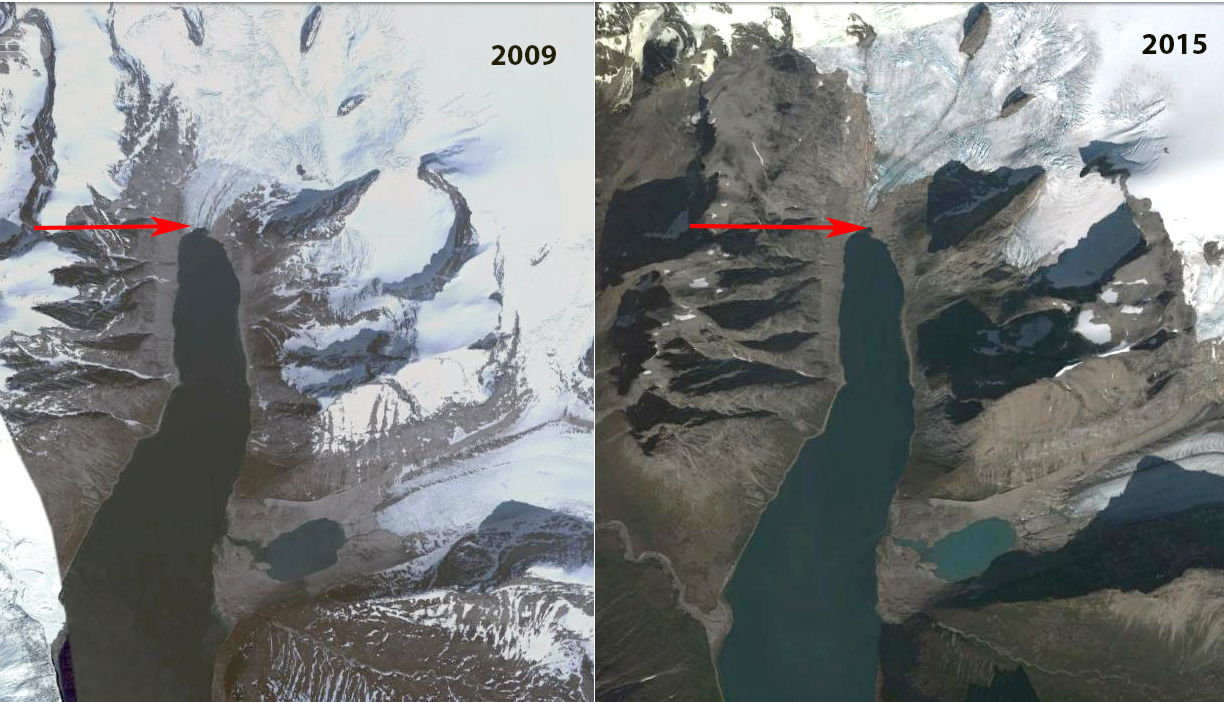
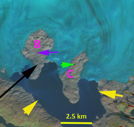
Apostelens Glacier in Norrearm Fjord Landsat comparison from 1999 to 2016. Red arrows are the 1999 terminus location, yellow arrows the 2016 terminus location and purple arrows indicate an expanding bedrock ridge.

“Apostelens” Glacier drains east from a peak of the same name into an arm of Norrearm Fjord, which in turn is part of Lindenow Fjord in southern Greenland. The glacier is a short distance north of Kangersuneq Qingordleq, where recent retreat has led to glacier separation. The glacier is soon to lose its tidewater connection as has occurred at Tasermiut Fjord to the west.  This will result in a decline in iceberg production as well.

Here we examine Landsat imagery from 1999-2016 to identify glacier change.  In 1999 the Apostelens arm of Norrearm Fjord is largely filled by the glacier which extends to within 2.5 km of Norrearm Fjord, red arrow.  The tongue contains numerous ogives formed each year due to seasonal velocity changes through an icefall.  This is evident in the Google Earth image from 2004, where 24 ogives are evident on the low slope glacier tongue, in 1999 the number is over 30. By 2013 the glacier has retreated nearly 2 km from the 1999 terminus position, red arrow. In 2012 Google Earth imagery indicates increased crevassing near the front and the loss of most ogives.  New ogive formation is also hard to distinguish.  By 2016 the glacier has retreated 2.6 km and is nearing the headward limit of the fjord arm.  The collapse of the fjord tongue and its associated ogives indicates the loss of 30 years worth of volume flux that emerged from the icefall that generated the ogives.

Greenland tidewater outlet glaciers in this region have experienced substantial retreat since 1990, Weidick et al (2012) and Howat and Eddy (2011).  Murray et al (2015) examined 199 tidewater glaciers in Greenland and noted significant retreat of 188 of them.  Apostelens Glacier was not one of these, and soon will not be a tidewater glacier to be included in the list.

norrearm-ge

Apostelens Glacier in Norrearm Fjord Google Earth comparison from 2004 and 2012. Red arrows are the 2004 terminus location, and yellow arrows the 2012 terminus location.  Note ogives in 2004 and loss of them in 2012. 

norrearm-map

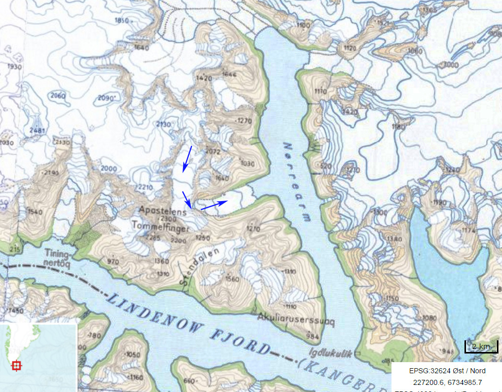
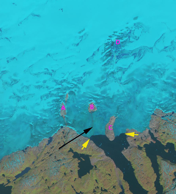
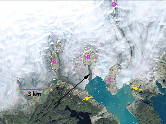
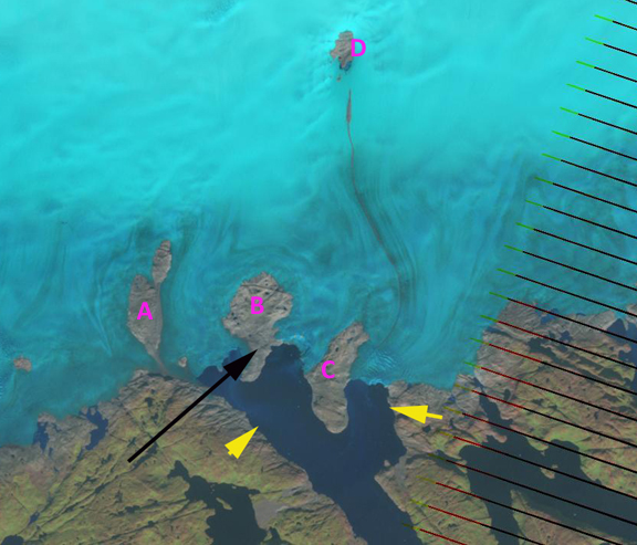
Map of the Norrearm Fjord region and Apostelens Glacier, with blue arrows indicating flow. 

Tasermiut Fjord, Greenland loses its Glacier Connection


tasermiut-compare-ls

Landsat image sequence from 1999-2016.  Red arrows mark the 1999 terminus, yellow arrows the 2016 terminus and the purple arrow a tributary that detaches from Semitsiaq (S). Tasermiut Sermeq (T) retreats from the fjord. 

Tasermuit Fjord in southern Greenland is noted for its beauty, and until recently the fjord terminated at a glacier front. Currently no glacier reaches to the fjord. The retreat over the last two decades is similar to neighboring glaciers Kangersuneq Qingordleq and Qaleriq.  The loss of direct glacier connection is also occurring at Alangordlia. Here we examine Landsat images from 1999-2016 to observe glacier change. At the head of the fjord is Sermeq Tasermiut and on the east side is Sermitsiaq.

In 1999 the Sermitsiaq Glacier terminated at the eastern end of a small lake, red arrow.  Tasermiut Sermeq terminated in the fjord, red arrow.  By 2002 Sermitsiaq had retreated from the lake, while Tasermiut Sermeq still reached the fjord.  In 2013 Tasermiut Sermeq had retreated from the fjord and Sermitsiaq had retreated substantially from the lake and also had a significant tributary from the north detach, purple arrow. In 2016 Sermitsiaq has retreated 700 m since 1999, yellow arrow.  Biggs (2011) had noted a 610 m retreat of the glacier from 1987-2009, a slower rate than since 1999. Tasermiut Sermeq has retreated 300 m since 1999,and has a narrow steep tongue that will melt back quickly in the near future.

Murray et al (2015) examined 199 tidewater glaciers in Greenland and noted significant retreat of 188 of them. This is changing fjord dynamics, which will in the case of Tasermiut affect the marine biology, which has not been studied in any detail yet. Students on Ice 2014 Arctic Expedition provides exceptional imagery of this fjord and the Nanotarlik region.

tasermiut-ge-compare

Google Earth imagery of the region. illustrating the loss of fjord connection after 2009.

tasermiut-map

Map of the region 

Qaleraliq Glacier Retreat, Southern Greenland

Qaleraliq Glacier is in southern Greenland and flows into the Tasermiut Fjord. Glaciers in this region have experienced substantial retreat since 1990 Weidick et al (2012) and Howat and Eddy (2011). Howat and Eddy (2011) state that, “We find that 90% of the observed glaciers retreated between 2000 and 2010, with rapid retreat observed in all sectors of the ice sheet. The current retreat is accelerating and likely began between 1992 and 2000, coincident with the onset of warming, following glacier stability and minor advance during a mid-century cooling period.” In this case we are examining a tidewater glacier in Southern Greenland using satellite imagery from 1992, 2004, 2010 and 2012. In each image locations A-D are in the same locations marking specific bedrock islands (nunataks) within the ice sheet. The yellows arrows indicate the 1992 terminus position in each image, the black arrow denotes the terrain south of bedrock nunatak B. Retreat of the west arm of the glacier has been 3.2 km from 1992 to 2012. The east arm retreat in the last twenty years has been 1.2 km. In 1992 Nunatak A is 1.5 km from the ice edge and is composed of two separate nunataks. By 2010 the two nunataks have merged and by 2012 Nunatak A is 1 kilometer from the ice edge. In 1992 Nunatak B is 3 km from the icefront surrounded by the ice sheet and in 2012 the nunatak has increased in size and extends 1 km beyond the terminus. Nunatak C has largely emerged from the ice sheet, the nunatak has also expanded in length by 500 meters as ice has thinned during the retreat. The Nunatak at D did not exist in 1992, but by 2012 it is over 1 km long.
qaleraliq 1992
qalaeriq ge
qaleraliq 2010
qaleraliq 2012
A close up view of the terminus and Nunatak B and C from 1992 and 2012 illustrates the expansion of the nunataks as ice has thinned. The locations at the green and purple arrows are the same in both images. In 1992 these locations are near the nunatak margin and by 2012 the locations are in the midst of the Nunatak. Qaleraliq Glacier behavior is similar to that of almost all southern Greenland glaciers, most of which like Qaleraliq have not been the focus of detailed study, such as Kuussuup Sermia, Narssap Sermia or Kangiata Sermia. In the Tasermiut Fjord Biggs (2011) noted the retreat of two glaciers Sermitsiaq and Itillersuaq that have each retreated 600 and 300 m respectively from 1987 to 2009.qualeraliq glacier 1992The unusual nature of the 2012 melt season can be seen in this animated graph of ice sheet melt extent with data from Marco Tedesco, Figure 2a in the recent paper submitted (Tedesco et al, 2012).

qualeraliq glacier 2012

Kuussuup Sermia, southern Greenland Retrea

Kuussuup Sermia is an outlet glacier in southern Greenland, 61.3 N 45.3 W. It actually a distributary glacier, with three different termini all ending in proglacial lakes, of the Qooqup (Qoorup) Sermia. The latter glacier calves into a fjord. Kuussuup Sermia separates at 700 meters from Qooqqup and terminates at 100 meters. The glacier’s equilibrium line where accumulation equals snow melt approximately is visible both in a Landsat Image from the summer of 2010. This annotated image indicates the main proglacial lake terminus (green arrow), secondary lake termins (pink), Qooqqup calving termini (purple), where the two seaprate (yellow) and the snowline (orange).. The snowline is at 1800 meters in this Sept. 10 image, the typical snowline is at 1700 meters. There are a large number of nunataks in the area of the snowline. If the high summer melt rates of the last decade continue these nunataks should expand. The snowline here is higher than in southeast Alaska, for example on Taku Glacier snowline (1000 meters), Pelto (2011). A comparison of the Landsat and Google Earth Imagery only span five years and show no significant changes. In Google Earth the terminus the green arrow area from the Landsat image is the focus, it is evident from 2005 (top) and 2009 (middle) during this period that the terminus has retreated 150 meters. What is more apparent bottom is that the lower 100 meters of the glacier is shattered and will be quickly lost (bottom) . The snowline in southern Greenland was exceptionally high in 2007 and 2010, as noted by Mernild et al (2011) on Mittivakkat Glacier and by Tedesco et al (2011) and Box et al (2011) in terms of the temperatures and melting observed.