Speel Glacier Retreats out of Alaska

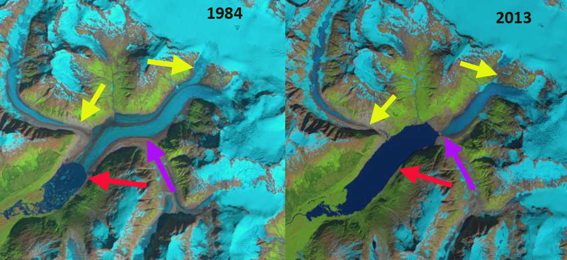
Speel Glacier in 1984 and 2022 Landsat images illustrating lake expansion and detachment of tributaries A-C. Red arrow is 1984 terminus location and yellow arrow is 2022 terminus location.

In 1984 I observed Speel Glacier while flying into Juneau, AK to work with the Juneau Icefield Research Program. Speel Glacier is south of the Taku Inlet and the Juneau Icefield draining west from a shared accumulation area with Wright Glacier. Unlike the map on my lap, there was now a big lake at the terminus of the glacier. This post examines the retreat of this glacier across the international boundary, out of Alaska, and the expansion of the unnamed lake at its terminus using Landsat images.

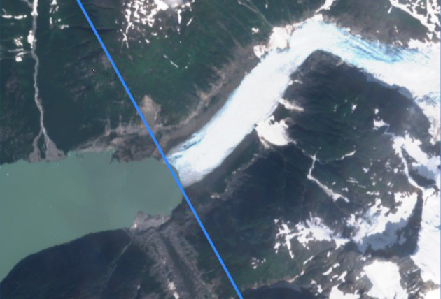
Speel Glacier terminus on 8-18-2022 with the Alaska/British Columbia boundary in blue.

In 1948 Speel Glacier ended at the head of a braided outwash plain, generated by the Speel River. Upglacier in 1948 there was a small side valley lake impounded by the glacier, Speel Lake. The lower part of the glacier was heavily debris covered and stagnant in 1948.  I  In the 1984 Landsat image the glacier had retreated 3 kilometers from the 1948 position and was fed by four separate tributaries flowing into the glacier A-D.  n 1984 the original Speel Lake had drained and a new lake had formed filling the valley that the glacier had filled in 1948. The proglacial lake was 2.2 km long. By 2003 the glacier had retreated an additional 1.8 km from 1984 to where the lake bends east, and the main tributary from the north separated from the glacier prior to 1984. By 2013 tributaries A and B had been completely separated.  In 2022 the glacier has retreated  6.35 km since 1948, 3.3 km since 1984 and the connection with the three of the four tribuaries had been lost A-C.  The tributary detachments have led to continued retreat, have reduced input to the main glacier, which by the summer of 2022 resulted in the glacier retreating across the international boundary from Alaska into British Columbia. The new lake is now over 7 km long, and should be called Speel Lake again. The retreat of this glacier fits the pattern of other glaciers in the region Field, Gilkey, and Tulsequah Glacier  (Pelto (2017). The  detachments are frequent and significanly impact ice dynamics on the Juneau Icefield (Davies et al 2022). There we found 176 such detachments/disconnections in the outlet and valley glaciers of the Juneau Icefield Davies et al (2022).

Speel Glacier in 1948 USGS map.

.

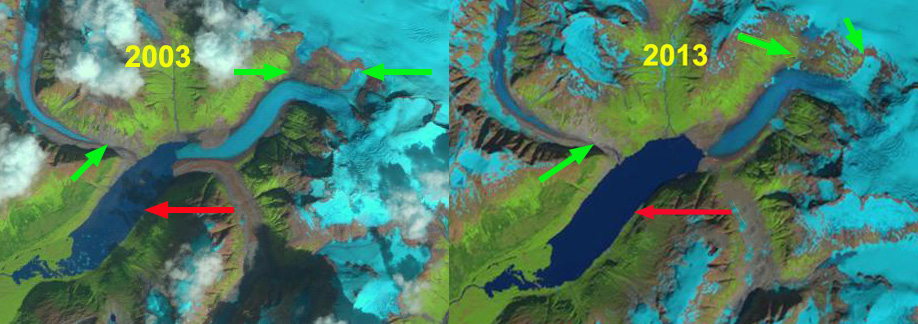
Speel Glacier in 2003 and 2013 Landsat images illustrating lake expansion and detachment of tributaries A-C. Red arrow is 1984 terminus location and green arrows are detachment of tributaries.


Speel Glacier Retreat, Coast Range Alaska

speel glacier 1984-2013
Speel Glacier a 3.2 km retreat from 1984-2013, lake expansion and tributary separation.
In 1984 I had a good chance to observe Speel Glacier while flying into Juneau, AK to work with the Juneau Icefield Research Program on the Juneau Icefield. Speel Glacier is south of the Taku Inelt east of Juneau, Alaska. Unlike the map on my lap, there was now a big lake at the terminus of the glacier. This post examines the retreat of this remote glacier and the expansion of the unnamed lake at its terminus. In 1948 Speel Glacier ended at the head of a braided outwash plain, generated by the Speel River. Upglacier in 1948 there was a lake impounded by the glacier, Speel Lake. speel glacier juneau Today Speel Lake is gone and a much larger proglacial lake exists. The lower part of the glacier was heavily debris covered and stagnant in 1948. By 1968 the glacier had retreated 1 km just to the edge of the current lake. In 1984 the lake was 2.2 km long. In the images below Landsat 1984, Google Earth 2003, Landsat 2006, Landsat 2009 and 2013, the primary accumulation zone is marked ACC, secondary accumulation areas are indicated by black arrows, the 1984 terminus pink arrow, 2003 terminus blue arrow, 2006 terminus green arrow, 2009 terminus yellow. In the 1984 Landsat image the glacier had retreated 2 kilometers from the 1968 position and was fed by a shared accumulation zone with the Wright Glacier-black arrows in addition to the main accumulation area of the glacier above the main icefall on the east side of the glacier. By 2003 the glacier had retreated 1.9 km to where the lake bends east, and the main tributary from the north separated from the glacier. In the 2006 imagery the glacier has retreated an additional 1.8 km. The connections with the Wright Glacier accumulation area had been lost. The tributary from the north that has its own accumulation zone was now completely separated. The glacier was then solely dependent on a single accumulation zone, ACC. In 2009 the glacier had retreated 200 meters from 2006. By 2013 the glacier had retreated from the lake entirely a 6 km retreat since 1948. This should lead to a reduced rate of retreat.

The rapid retreat of this glacier has reduced its area at low elevation considerably. This is improving the glaciers accumulation area ratio, to be in equilibrium the glacier needs at least 60% of its area to be in the accumulation zone, in this region Pelto (1987) noted that no glaciers in the region were advancing that did not have an accumulation area ration above 67. In 1984 the accumulation area ratio was 48. In 2006 the AAR is 54, ablation area is being lost faster than accumulation area. The icefall marks the boundary between the ablation zone and the accumulation zone.The retreat of this glacier fits the pattern of other glaciers in the region Eagle, Field, Gilkey, and Chickamin. Today the lake averages nearly 1.5 km in width and is over 5 km long.
Landsat imagery 1984

2003 Google Earth image

Landsat imagery 2006

2009 Landsat image
speel glacier 2013
2013 Landsat image- Red arrow is 1984 terminus, purple the 2013 terminus and yellow arrows detached former tributaries.