Sawyer Glacier, Tracy Arm Alaska Retreats from Tidewater

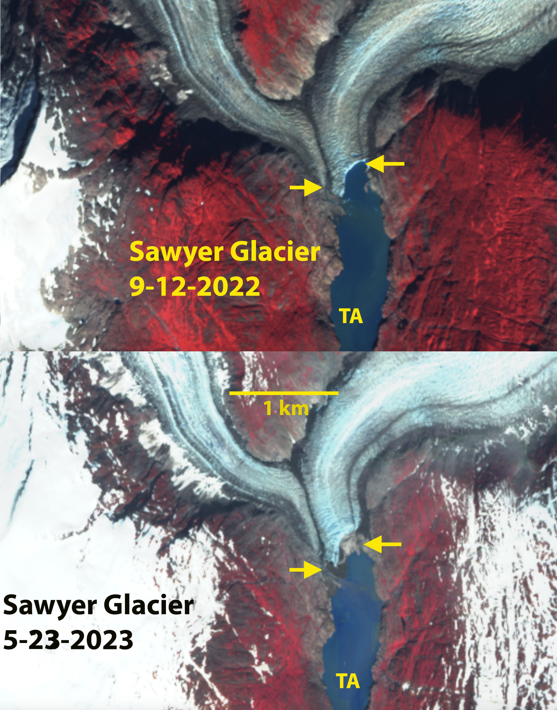
Sawyer Glacier Alaska in False Color Sentinel images from Sept. 12, 2022 and May 23, 2023. Note the the calving face in 2022 between the yellows arrows has become bare ground by May 23, 2023. TA=Tracy Arm

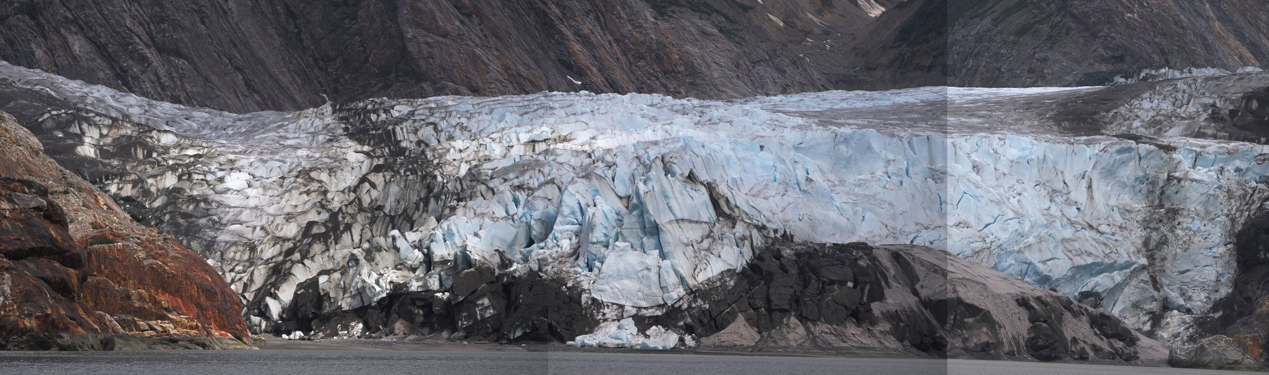
Sawyer Glacier in May 19, 2023, taken by Steve Backus (Lindblad Expeditions Naturalist), not touching tidewater.

Sawyer Glacier, is an Alaskan glacier where the retreat has long been viewed by many visitors. It is one of  the two primary glaciers that calves into Tracy Arm fjord, that is often visited by cruise ships. The 3.3 km retreat from 1961-2022 has made approach to the actual terminus difficult for larger cruise ships (Lindblad Expeditions, Allen Marine Tours or Holland Amreica) . The terminus of the glacier was almost to the main arm of the fjord in 1961, USGS map below.  Landsat images from 1990 to 2013 indicate retreat from the 1990 terminus, red arrow, to the 2013 terminus, yellow arrow is 2800 km, 120m/year. From 2013-2022 the retreat has been slower with ~500 m retreat, 50 m/year.

Sawyer Glacier retreat from 1990 to 2013 in Landsat images. Yellow arrow=2013 terminus; Red arrow=1990 terminus; purple arrow

Sawyer Glacier retreat from 1990 to May 10, 2023 in Landsat images. Green Arrow=2023 terminus Yellow arrow=2013 terminus; Red arrow=1990 terminus; purple arrow

From 1874 when John Muir first enthused about the calving glaciers of this fjord through 2022 their has been a calving front in the fjord.  This was true as the cruise ship season ended in 2022. False color Sentinel images in Sept. and Oct. 2022 indicate a calving front that is 250 m wide. False color Sentinel images on May 10 and 23, 2023 indicate the front of the glacier entirely resting above fjords waters. High tide may touch the glacier at ts southernmost point. When I first visited the in 1982 I could not imagine it retreating from the fjord in my lifetime. Melkonian et al (2016) observed a rapid thinning of the Stikine Icefield of -0.57 m/year from 2000-2014. This loss has been driving by rising snowlines.  Pelto (1987) reported a snowline of 1125 m the 1980’s, that now averages over 1300 m. The retreat here is similar to that of nearby Dawes and South Sawyer Glacier. This loss of iceberg  production will impact harbor seals as they prefer icebergs to haul out on. (Alaska Department of Fish and Game ).

May 10 and 23, 2023 Sentinel images indicating bare ground across entire terminus front.

Sawyer Glacier Alaska in False Color Sentinel images from Sept 12, 2022 and Aug. 7, 2016. Note the the calving face in 2016 and 2022 between the yellows arrows.

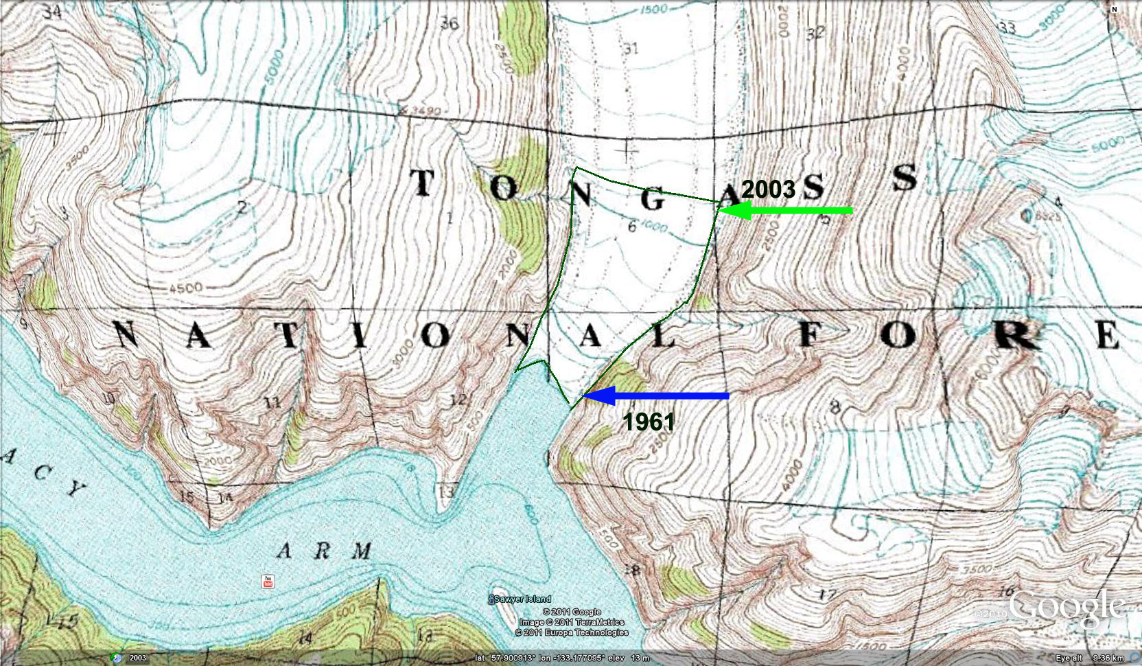
USGS 1961 topographic map showing location of terminus in 1961 and 2003.

South Sawyer Glacier Retreat and Separation, Alaska

south sawyer terminus compare

Comparison of South Sawyer Terminus position and unnamed glacier just to the south.  Red arrows are the 1985 terminus and yellow arrows the 2016 position of each terminus. 

South Sawyer Glacier is a 50 km long tidewater glacier terminating at the head of Tracy Arm fjord in Southeast Alaska.  The winding fjord surrounded by steep mountains is fed by Sawyer and South Sawyer Glacier is home to stellar sea lions, humpback whales and harbor seals.  This combination makes it attractive for cruise ships.  Mike Greenfelder a Naturalist/Photography Instructor with Lindblad Expeditions suggested I examine this glacier, and he provided several images. I had a chance to observe the glacier in 1982 and 1984 and noted that the snowline of the glacier at 1125 meters by Pelto (1987), using Landsat images.  We also identified the water depth at the glacier front was 180-200 m and the velocity of the calving front in the 1980’s was 1800 m/year (Pelto and Warren, 1990).  Today the velocity had declined  to less than half of this, which is expected given that water depth at the front in the most recent charts from 1999 indicate 1985 terminus position water depth is 110 m (Elliot et al, 2012). This is deep but not as deep as in the 1980’s, the greater the water depth, the greater the degree of buoyancy at the front and the higher the calving rate. The glacier retreated 3.5 km from 1899-1967 and then experienced little retreat from 1967 to 1985 (Molnia et al, 2008). Larsen et al (2007) observed a rapid thinning of the Stikine Icefield during the 1948-2000 period.The retreat has been driven by rising snowlines in the region that has driven the retreat of North Dawes, Baird, Dawes and Sawyer Glacier. Here we use Landsat images to indicate from 1985-2016 to identify terminus change and recent snowline elevation.

The terminus has retreated 2300 m from 1985 to 2016, with little retreat from 1985 to 1996.  Of equal importance is the glacier now appears to be near the tidewater limit of Tracy Arm.  In the gallery of terminus images below from Mike Greenfelder, the 2005 and 2012 images illustrate a sharp increase in slope at Point B and red arrows in 2015 just the red arrows, 300 m from the ice front.  In 2016 the ice front is nearly to the base of this icefall. This represents a sharp rise in the bed of glacier causing an icefall.  Whether the bed is entirely above sea level is not clear. Just south of the main terminus is a separate glacier that in 1985 was the combination of two tributaries.  By 2016 the two glaciers have separated with a retreat of  4.5 km for the western arm and 3.8 km for the eastern arm.

In the gallery of snowline images it is evident that upglacier there are two tributaries that joined the main glacier in 1985, that no longer reach the glacier in 2016.  This is indicative of the higher snowlines and thinning glacier. The gallery of snowlines  indicate the last date during the melt season with clear imagery of the snowline.  In 1985 the snowline was at 1250 m, in 1996 the snowline was at 1400 m, in 2013 1400 m, in 2014 1600 m, in 2015 at 1400 m and in 2016 at 1650 m.  The images are close to the end of the melt season, but are a minimum elevation for the equilibrium line.  The snowline is averaging 300 m higher than it did in the 1980’s. The retreat of South Sawyer Glacier and its iceberg production will slow as the water depth at the front declines in the near future.  The retreat will continue due to the sharp rise in snowlines that has occurred which has led to significant thinning up to 1500 m noted by Larsen et al (2007). The retreat of neighboring non-calving glaciers emphasizes this point.

[ngg_images source=”galleries” container_ids=”27″ display_type=”photocrati-nextgen_basic_imagebrowser” ajax_pagination=”1″ template=”/nas/wp/www/sites/blogsorg/wp-content/plugins/nextgen-gallery/products/photocrati_nextgen/modules/ngglegacy/view/imagebrowser-caption.php” order_by=”sortorder” order_direction=”ASC” returns=”included” maximum_entity_count=”500″]