
The summer of 2023 was our 40th field season observing the response of North Cascade glaciers to climate change. Each year we visit a series of glaciers on the same date to complete our annual examination. We carry all of the equipment to each field site in backpacks and camp in tents near the glacier. All the glaciers we observe, except Easton Glacier, are in Wilderness Areas. This precludes the use of mechanized equipment or leaving instruments behind. We work each day in almost any weather conditions, and in the last decade that means dealing with forest fire smoke, only a few days have forced us to remain in our tents. We have covered over 5,000 miles, completed over 40,000 measurements and spent 800 nights in tents during the course of this research project. Three of the glaciers we observe are World Glacier Monitoring Service reference glaciers (42 in the world).
The field team consisted of Jill Pelto (Art Director), Mauri Pelto (Science Director), Julia Ditto (Field Artist), Mariama Dryak (Field Scientist-Team Logistics), Kai Yuan Wang (Field Scientist) Muruganandham Shivaprakesh (Field Scientist). For the third straight year conditions were poor for the glaciers. The 2021-2023 period was the worst three year stretch during the last 40 years with glaciers losing ~5-6 m of thickness, which is 10-20% of glacier volume depending on the glacier.
“40 Years in the North Cascades” by Jill Pelto. This painting is an emotional piece for me. It is an updated version of the very first data-art painting I created when I came up with the idea in 2015. The top surface of the mountain glacier is a line graph that depicts the mass balance of North Cascade glaciers in Washington state from 1984-2022.
We have observed the loss of three of our key glaciers we monitor, every glacier in the range has experienced significant retreat, and volume loss. Our mass balance observations indicate an average loss of 27 m water equivalent, ~30 m in thickness and ~35-40% of the entire volume of the glaciers in the mountain range lost. The summer of 2023 had the largest loss of glacier area of any of our 40 years, average terminus retreat exceeded 25 m. Ice Worm Glacier ceased to be an active glacier, joining a rapidly growing list of glaciers that are no more. The glaciers on Mount Daniel/Hinman in particular collapsed. The main variable we measure to determine glacier health is mass balance, the difference in snowfall gain vs. melt each year. The result of three bad years in a row 2021-2023, with losses exceeding -1.5 m led to this rapid retreat. The extent of blue ice was the highest we have observed on both Mount Daniel (95%) and Mount Baker (70%). This made traversing the glaciers more challenging. The added newly deglaciated unstable terrain also added challenge in accessing the glaciers.
Sholes Glacier is on a ridge extending northeast from Mount Baker and is at the headwaters of the North Fork Nooksack River. With the Nooksack Tribe we measured glacier runoff below this glacier from 2012-2021. The glacier mass balance is 24.5 m, with 2023 comprising 10% of that. The glacier has lost 10 m of thickness in the last 5 years, driving a rapid increase in retreat rate and opening a large ice cave near terminus.
Columbia Glacier is a cirque glacier at the headwaters of the North Fork Skykomish River. It is fed by avalanches mainly from the west side (left in images). The glacier retreat has accelerated in the last decade exposing a growing new lake. By 2023 the glacier has lost 40% of its volume since 1984. This is a World Glacier Monitoring Service reference glacier, one of 42 in the world. The slopes above the glacier have lost considerable perennial snowpack leaving much deeper depressions/basins that must be filled in the winter before avalanching commences. This has reduced the input of avalanches for the glacier.
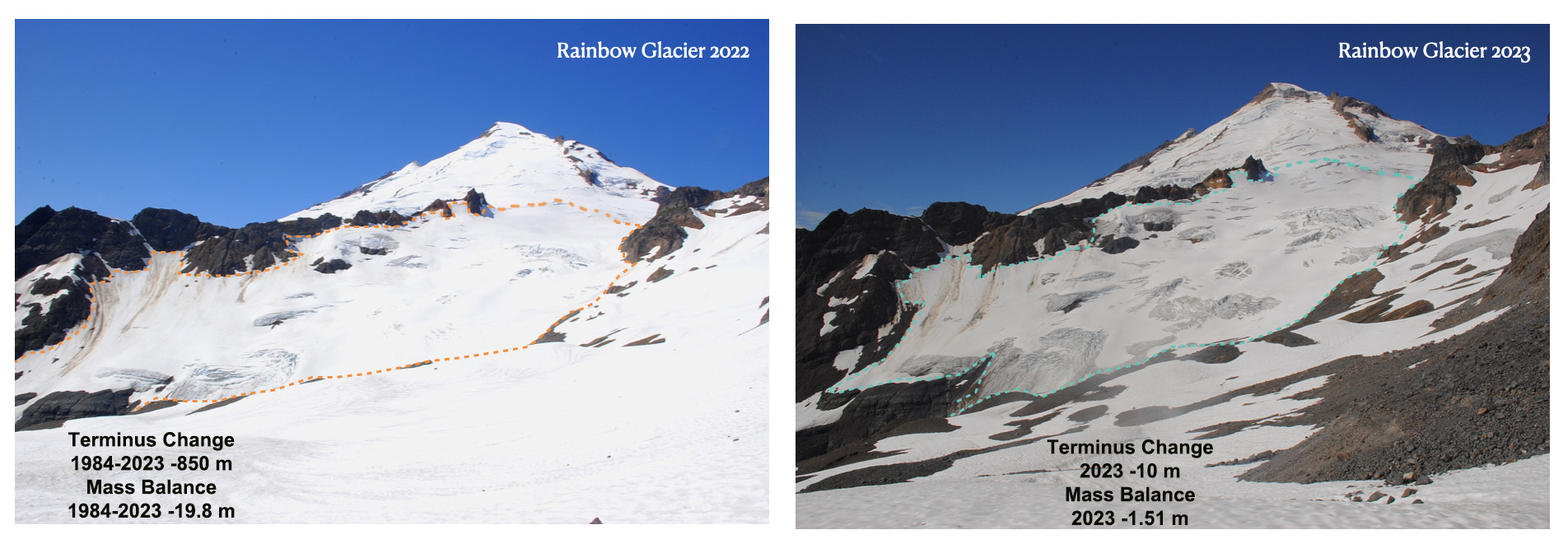
Rainbow Glacier is on the northeast side of Mount Baker and is a valley glacier that feeds Baker Lake. The glaciers starts at 2100 m at a junction with the Park and Mazama Glacier. This is a WGMS reference glacier. The glacier mass balance loss has been 19.8 m, the slowest rate of any of the glaciers. The terminus has retreated 850 m.
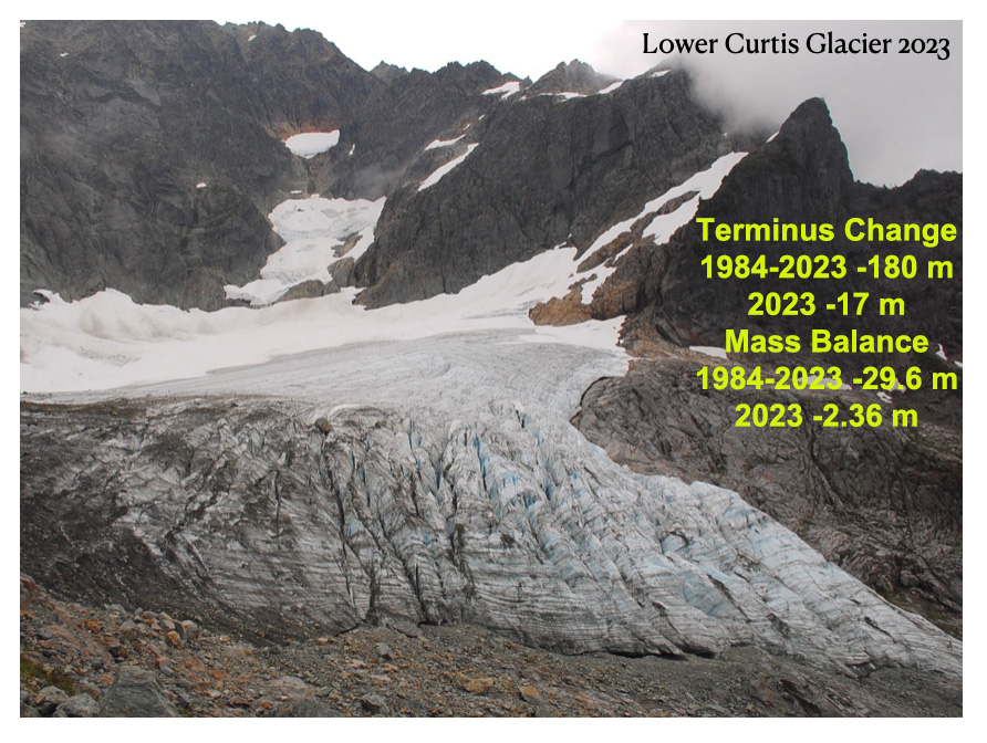
Lower Curtis Glacier is a cirque glacier on Mount Shuksan. The glacier is avalanche fed and feeds Creek and then Baker Lake. The glacier has a steep seraced thick terminus front that reduces retreat rate, though this icefall has thinned rapidly in the last 5 years. Retreat has been 180 m since 1984, but will continue to increase due to the rapid thinning. Mass balance loss of 29.9 m is leading to significant marginal recession too.

Easton Glacier is a slope glacier on the south side of Mount Baker. The glacier feeds into Sulphur and Rock Creek and then the Baker River system. Sulphur Creek is diverted into Baker Lake. This is a WGMS reference glacier and has a mass balance loss of 24 m since 1990. The retreat of this glacier from the 1955-1980 period of advance was minor until 1992. Since then the retreat has been 570 m, including 100 m in the last two years.

Field team standing at the 2022 terminus location of Easton Glacier looking at one year of retreat on August 11, 2023.
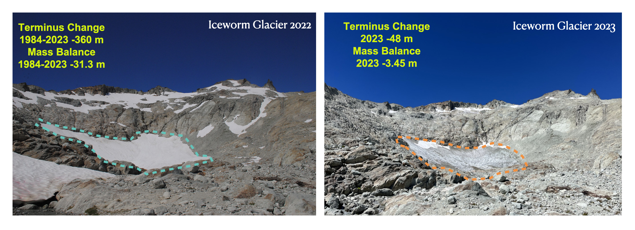
Ice Worm Glacier is a small cirque glacier on the east side Mount Daniel feeding the Cle Elum River. The glacier has been retreating rapidly both at the terminus and at its head. The rapid area thinning and retreat from 2021-2023 resulted in many stream channels in the glacier reaching bedrock. The glacier mass balance has been -31.3 m since 1984, which is about 80% of its initial volume. Depth to bedrock is typically 4-6 m. The area of this glacier has dropped to 40,000 m² and it is no longer moving. Hence, this is now just relict ice, not an active glacier.
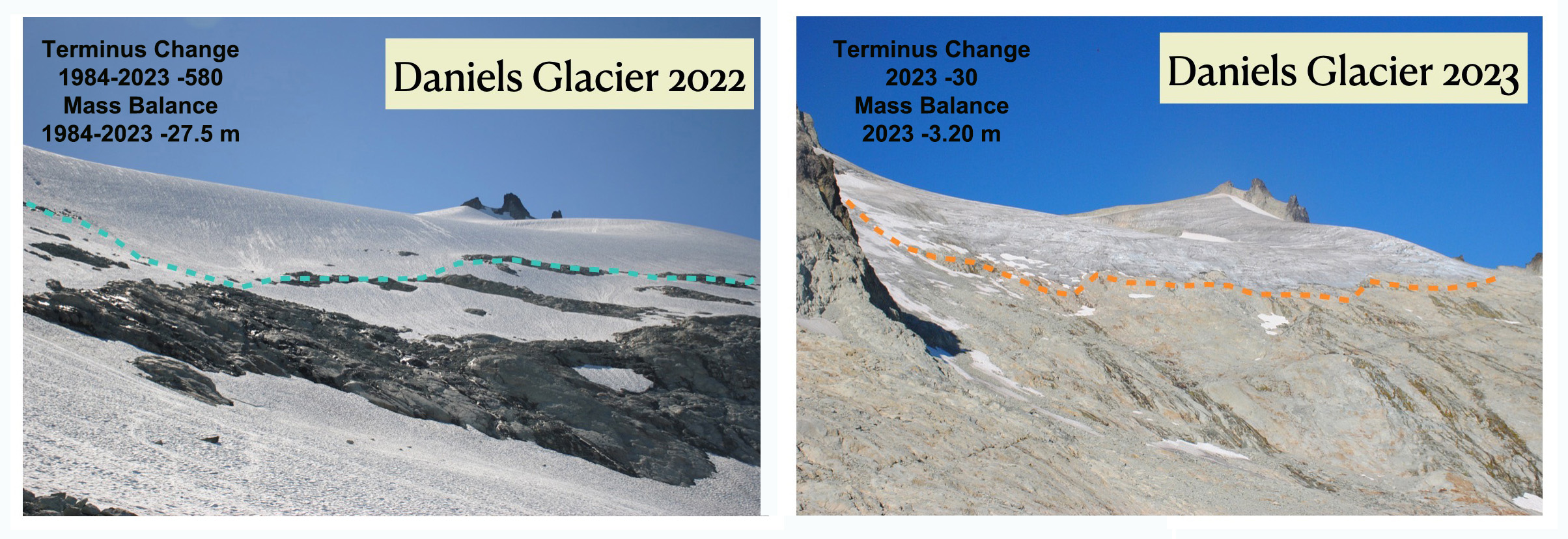
Daniels Glacier is a small slope glacier on the east side Mount Daniel feeding the Cle Elum River. The glacier dominated the east side of Mount Daniel in 1984, but now only 30% remains. Rapid mass loss of 27.5 since 1984 is leading to continued rapid disintegration of this now thin glacier. We observed many crevasses reaching bedrock even well above the terminus in 2023.

Lynch Glacier is on the northwest side of Mount Daniel at the headwaters of the South Fork Skykomish River. In 1984 the lake below was pea soup colored and filled with icebergs. Now it is a deep azure blue. The glacier has lost 25.4 m leading to rapid disintegration of the western side of the glacier. The steep thick terminus ending in the lake has retreated more slowly than other glaciers, but the volume loss has been similar.
In our camp on the North side of Mount Baker after a day on Rainbow Glacier, looking for mountain goats.

