Cerro Tronador Glacier, Argentina Retreat and Lake Formation

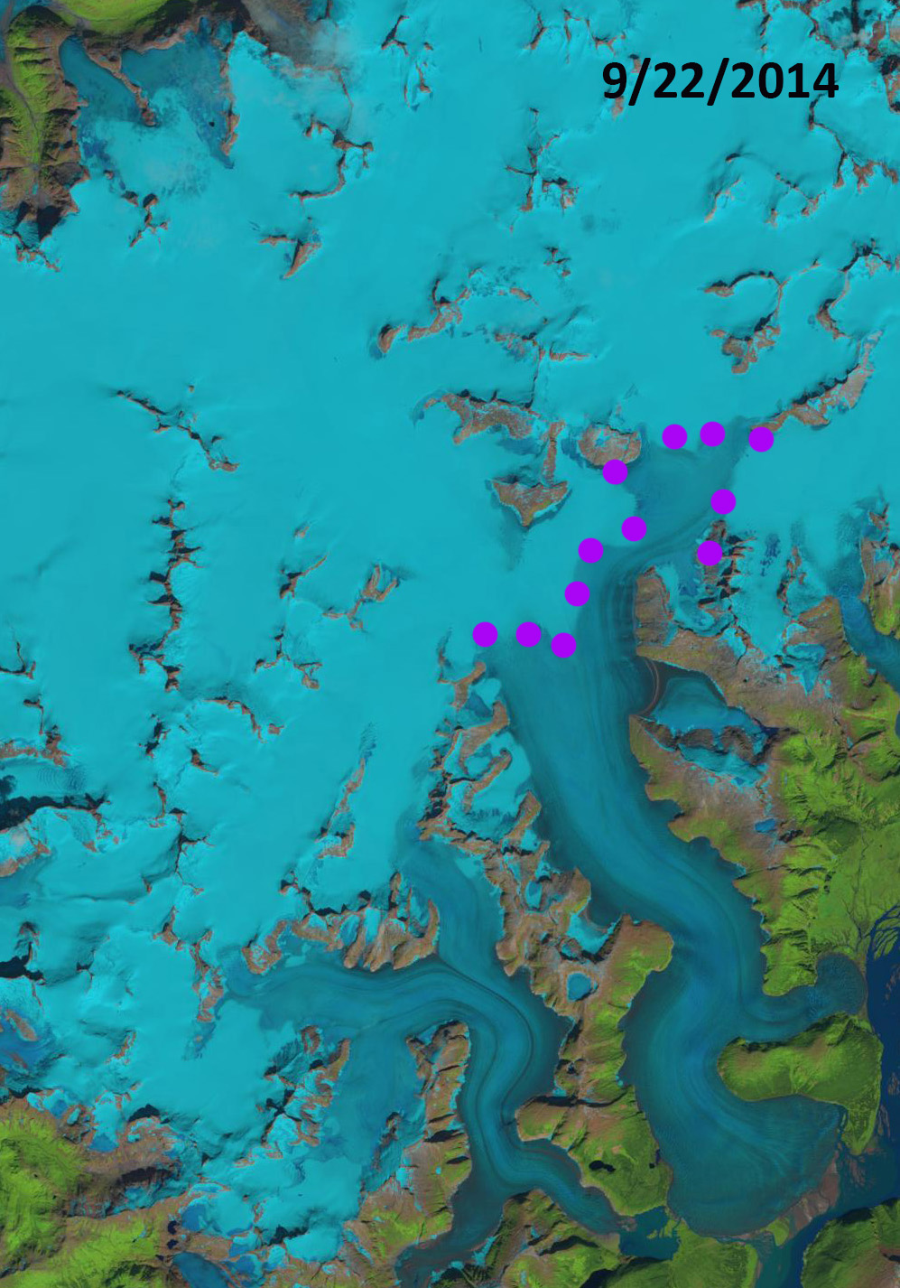
Cerro Tronador glaciers in Landsat images from 1985, 1998 and 2018.  A=Alerce, CO=Castana Overo, VN=Ventisquero Negro.  Red arrows mark the 1985 glacier terminus locations, yellow arrows the 2018 terminus location of VN, pink arrow the location of the 2009 dam breach outwash plain deposit, and purple arrow location of a bedrock outcrop. 

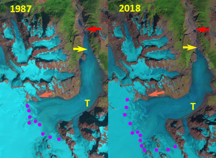
Cerro Tronador with a summit elevation of 3428 m straddles the Chile/Argentina border east of Lago Todos los Santos.  The peak is heavily glaciated including three glaciers that flow into the Alerce River basin of Argentina, Ventisquero Negro (VN), Castana Overo (OV) and Alerce (A).  Paul et al (2014) observed a 25% decrease in glacier area and the formation of over 100 new proglacial lakes in Northern Patagonia. Worni et al (2014) report on a moraine dam breach below Ventisquero Negro in 2009 and model this event. Here we examine Landsat imagery from 1985 -2018 to identify changes.

In 1985 there is no lake at the terminus of Ventisquero Negro with the debris covered terminus extending across the entirre basin.  The pink arrow indicates the vegetated valley below the moraine.  Alerce Glacier extends over a topographic step at 1600 m and extends to a proglacial lake at 1350 m. Castana Overo Glacier terminus broadly extends over the topographic step at 1600 m.  By 1998 Ventisquero Negro has developed a small fringing proglacial lake.  Alerce Glacier has lost its lowest valley tongue that extended to the proglacial lake.  The width of the Castana Overo Glacier terminus has been reduced.

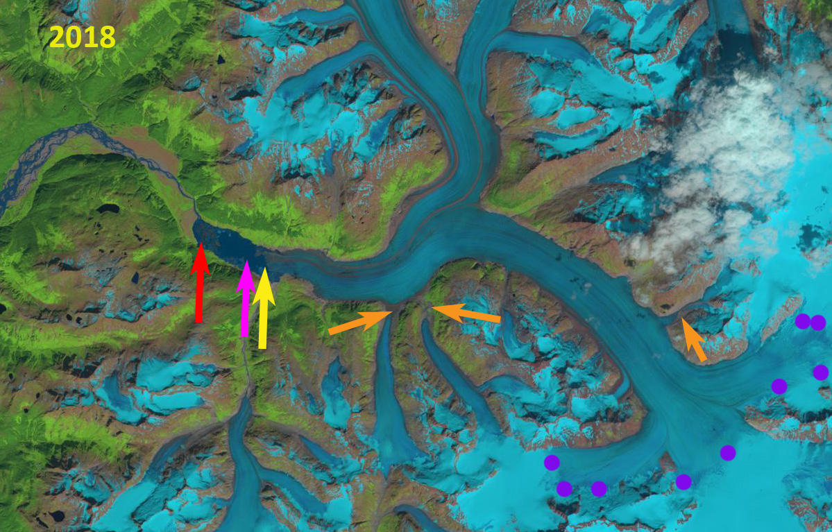
By 2012 below the moraine dam breach has occurred depositing a significant outwash plain that is evident at the pink arrow just downstream of Ventisquero Negro.  A substantial proglacial lake has also formed that is 1.2 km long, Lago Manso.  Alerce Glacier has retreated to the top of the 1600 m step. A new bedrock outcrop, purple arrow has appeared on the ridge between Alerce and Castana Overo Glacier at 2100 m.  In 2016 the snowline extends to the new bedrock outcrop. By 2018 Ventisquero Negro has retreated 1450 m since 1985, with the proglacial lake still growing.  Alerce Glacier has retreated 800 m since 1985 and Castana Overo Glacier has retreated 400 m.  All three glaciers have significant crevassing indicating substantial retained accumulation being transported down slope. The debris covered tongue of Ventisquero Negro will continue to disintegrate and the Lago Manso will continue to expand.

Cerro Tronador glaciers in 2012 Google Earth image.  A=Alerce, CO=Castana Overo, VN=Ventisquero Negro.  Red arrows mark the 1985 glacier terminus locations, , pink arrow the location of the 2009 dam breach outwash plain deposit, and purple arrow location of a bedrock outcrop. 

Cerro Tronador glaciers in 2016 Digital Globe image.  A=Alerce, CO=Castana Overo, VN=Ventisquero Negro.  Red arrows mark the 1985 glacier terminus locations, , pink arrow the location of the 2009 dam breach outwash plain deposit, and purple arrow location of a bedrock outcrop. 


Reru Glacier, Kashmir Retreat and Lake Expansion

Reru Glacier in 1998 and 2018 Landsat images.  The red arrow indicates the 1998 terminus location, the pink arrow a recent landslide, Point 1 and 2 are tributaries that are losing connection with the main glacier and purple dots are the snowline.

Reru Glacier, Kashmir is at the headwaters of the Reru River, which drains into the Doda River and then the Zanskar River.  Murtaza et al (2017) noted a 17% loss in glacier area and a 80-300 m rise in the ELA of Kashimir glaciers form 1980-2013. This is similar to the rate of loss from 1962-2001 of 18% reported by Rai et al (2013) The Kolahoi Glacier has experienced an accelerated retreat in the last decade (Rashid et al, 2017)Babu Govindha Raj (2010) identified  the glacier retreating at an average rate of 12 m per year from 1975-2005,  with lake area expanding from 0.17  to 0.42 square kilometers.  Here we examine Landsat images from 1998-2018 to document changes of Reru Glacier.

In 1998 the glacier terminates in a 1 km long lake. The snowline is at 500 m, and tributaries at Point 1 and 2 flow into the main glacier. In 2002 the snowline is at 5300 m, the tributaries still join the main glacier and no landslide is evident at the pink arrow.  By 2014 the glacier terminates in the proglacial lake that has expanded to 1.6 km in length and tributary 1 has detached from the main glacier.  The snowline is at 5100 m.  In 2018 the glacier has retreated from the proglacial lake which is 1.7 km long.  The glacier has retreated 600-700 m since 1998.  A landslide is now evident at the pink arrow. Potentially from the period of intense flooding in 2015. Tributary #2 has a narrow but existing connection to the main glacier. The snowline in 2018 is particularly high at 5700 m. This is reflective of the high freezing levels in this area in 2018.  The retreat is significant, but not rapid.  This is similar to both Kolahoi Glacier and Durung Drung Glacier.

Reru Glacier in 2002 and 20184 Landsat images.  The red arrow indicates the 1998 terminus location, the pink arrow a recent landslide, Point 1 and 2 are tributaries that are losing connection with the main glacier and purple dots are the snowline.

Breney Glacier Switzerland Accelerating Retreat 1988-2018

Breney Galcier, Switzerland in Landsat images from 1988 and 2018.  Red arrow = 1988 terminus location, yellow terminus =2018 and purple dots the snowline.  B=Breney Glacier, G=Gietro Glacier, L=Lateral Moraine, M=Lac Mauvoisin and O=Otemma Glacier.

Breney Glacier (B) is in the next valley to the north of Otemma Glacier (O) and south of Gietro Glacier (G), it  flows southwest into Lac de Mauvoisin (M). Breney Glacier is one of the glaciers where the terminus is monitored annually by the Swiss Glacier Monitoring Network (GLAMOS:VAW/ETH). Here we examine changes in this glacier from 1988 to 2018 including changes in the terminus using Landsat Imagery.  GLAMOS:VAW/ETH reports that Breney Glacier retreated 175 m from 1988-1999, and a further 625 m from 1999-2015.   The Mauvoisin Dam can produce 363 MW of power, and typically provides 1030 millionKWh of power each year. The reservoir can store 200 million cubic meters of water.

Here we examine Landsat images to identify changes in this glacier during the last three decades 1988-2018.  In 1988 the glacier extended onto an outwash plain at 2600 m and the snowline was at 3300 m.  In 1999 the snowline is at 3200 m, the terminus has experienced limited retreat across the low slope outwash plain.  By 2015 the terminus has retreated to ~2700 m, the snowline is at 3500 m.  In 2018 the snowline is at 3500-3600 m too high to sustain the glacier at its current length.  The glacier has retreated from the outwash plain that is still accumulating sediment.  There is significant retreat from 2015 to 2018, more than 100 m. There are regions of ice cored moraine (ICM).  The current lateral moraine that is visible on both margins of the glacier illustrates the recent rapid thinning and the insulating effect of the debris.  There is limited crevassing on the lower glacier which is dissected by a supraglacial stream, note detailed Google Earth image below. The northern arm of Breney is Serpentine Glacier, which is thinning and appears close to separation from Breney Glacier. The retreat is similar in magnitude to adjacent Otemma Glacier (O) and south of Gietro Glacier (G), all driven by high glacier melt and the resulting high snowlines.  The mass balance of Swiss Glaciers has had a sustained strongly negative trend since 2003 (Huss et al 2015).

Breney Galcier, Switzerland in Landsat images from 1988 and 2018.  Red arrow = 1988 terminus location, yellow terminus =2018 and purple dots the snowline. 

Google Earth image from 2016 of the terminus area of Breney Glacier. K=Kettle, OP=Outwash Plain, T=Terminus, S=Supraglacial stream, ICM=ice cored moraine.

Wrangell Mountain Icefields, Alaska Lose their Snowcover 2016 and 2017

Mount Gordon Icefield (MG) Mesa Creek Icefield (MC) and Icefield Plateau (IP) in 2016 and 2017 Landsat imagery.  The purple dots indicate the areas with retained snowcover in both years. Nabesna Glacier (N) is the largest glacier in the Wrangell Mountains, just a corner seen here.

Mount Gordon Icefield (MG) Mesa Creek Icefield (MC) and Icefield Plateau (IP) are three neighboring Icefields in the Wrangell-Saint Elias National Park and Preserve in Alaska.  Each has a principal accumulation area between 2300 and 2550 m, with a limited area above .  The area of Mount Gordon Icefield is ~10 square kilometers, Mesa Creek Icefield ~12 square kilometers and Icefield Plateau ~35 square kilometers. This is a region that has been experiencing significant mass loss.  Das et al (2014) used repeat altimetry measurements to identify accelerated mass loss over the Wrangell Mountains, from –0.07 ± 0.19 m w.e./year during 1957–2000 to –0.24  m w.e./year during 2000–07.  Larsen et al (2015) identified that the Wrangell Mountains experienced a mass balance of -0.5 to -1 m/year  from 1994–2013 using laser altimetry.

On August 17, 2016 less than 10% of the Icefield Plateau is snowcovered, with the snowline at 2500 m.  The snowline is at 2400 m on Mount Gordon Icefield and Mesa Creek Icefield with 30% of each icefield retaining snowcover.  On August 4, 2017 there is insignificant retained snowcover on Mesa Creek Icefield.  The snowline is at 2500 m on both Mount Gordon Icefield and Icefield Plateau with less than 10% overall retained snowcover.  The lack of retained snowcover across most of the former accumulation area from 2300-2550 m indicates these icefields will have substantial icefield wide thinning.  In addition the lack of a persistent substantial accumulation zone indicates the icefield will not survive, though a small mountain glacier may remain on the est side of Mount Gordon and the southern edge of the Icefield Plateau. In 2018 there is not a good cloud free August image from this region. The high snowline and rapid melt on nearby Lowell Glacier suggest the snowline would again have been high. This will lead to substantial retreat of the icefield margins and is indicative of the retreat of large glaciers in the range such as Nizina Glacier or Yakutat Glacier in the Saint Elias Range.

Mount Gordon Icefield (MG) Mesa Creek Icefield (MC) and Icefield Plateau (IP) in topographic map.

Mount Gordon Icefield (MG) Mesa Creek Icefield (MC) and Icefield Plateau (IP) in 1999 Landsat image.  The purple dots indicate areas with retained snowcover. N=Nabesna Glacier.

Mount Gordon Icefield (MG) Mesa Creek Icefield (MC) and Icefield Plateau (IP) in 2001 Landsat image.  The icefield are nearly fully covered with snow. N=Nabesna Glacier.


Lapche Glacier, China Supraglacial Ponds Transitioning to Lake

Lapche Glacier (Tibet 1), China in 1992 and 2018 Landsat images.  The expansion of supraglacial ponds is evident between Point 2 and 3. A tributary that detaches between 1992 and 2018 is indicated by red arrow.  The end of the clean ice and start of debris cover ice is just below Point 1 in 1992 and well above this Point in 2018. 

Lapche Glacier (Tibet 1), China flows east from Lapche Kang (Lobuche Kang) in the Bum Chu River Basin. King et al (2017) examined the mass balance of 32 glaciers in the Everest region for the 2000-2015 period including the Lapche, which they called Tibet 1, and found a mass loss of ~0.5 m/year, with the loss of lake terminating glaciers at ~-0.7 m/year.  King et al (2017) also observed that a number of these glaciers had nearly stagnant tongues with coalescing and expanding supraglacial ponds. Here we examine the expansion of the supraglacial ponds from 1992 to 2018 using Landsat images.

The lower four kilometers of Lapche Glacier in 1992 is relatively flat with the terminus at 5100 m and four kilometers upglacier at just 5200 m. In this stretch there are several small isolated supraglacial ponds between Point 2 and 3.  At Point 1 is the end of the clean ice section of the glacier, with debris cover obscuring the underlying ice below this point. There is a tributary joining the glacier at the red arrow. In 2001 the snowline is at 5600 m, and there are a few more supraglacial ponds, but with a total surface area under 0.1 square kilometers.  In 2015 the tributary at the red arrow has detached and the area covered by ponds has expanded and now cover ~0.5 square kilometers.  The snowline in 2015  is at 5650-5750 m. In 2018 the supraglacial ponds have largely coalesced, and have an area of ~1.0 square kilometers.  These lakes are on the verge of creating one larger lake as has happened on Rongbuk Glacier .  The debris covered portion of the glacier now begins above Point 1, 1 km upglacier of its 1992 location.  The snowline in 2018 is at 5650-5750 m.

King et al (2018) indicate a velocity of less than 10 m/year in the lower 5 km of the glacier, essentially stagnant.  Point 1 is just over 6 km above the 1992 terminus. The retreat here is difficult to discern, but with the proglacial lake development it will soon be identifiable and in line with that of other glaciers in the area Duiya and Yanong.   Zhang et al (2010) observed the loss of glacier area and lake expansion in the region from 1976-2006 driven by warming.

Lapche Glacier (Tibet 1), China in map view.  Point 1-3 same as in images, ice flow indicated by blue arrows, elevation contours labelled at 51oo and 5200 m. Debris cover beginning noted at DC.

Lapche Glacier (Tibet 1), China in 2001 and 2015 Landsat images.  The expansion of supraglacial ponds is evident between Point 2 and 3. A tributary that detaches between 2001 and 2015 is indicated by red arrow.  

Sermip Nunataa, Greenland No Longer a Nunatak

Sermip Nunataa (S) and nearby nunataks in 1993, Q, R and B in 1993 and 2018 Landsat images.  Red dots indicate the 1993 margin. 

Sermip Nunataa (Nunatak-Island within ice sheet glacier) was a nunatak of the southern Greenland Ice Sheet between Sermilik Brae and Sondre Qipisaqqu Brae.  Here we examine changes from 1993-2018 of the margin of the ice sheet in the area and the impact on this and neighboring nunataks.

In 1993 the Sermip Nunatak was 2.5 km inland from the ice sheet margin.  At Nunatak R there is a single short ridge, 1.5 km long.  Nunatak Q is 3 km from margin and Nunatak B is 1.5 km from margin.  By 2004 the two glacier tongues encircling Sermip are beginning to separate. Nunatak R is 2 km long. Nunatak B has expanded in length and width. Nunatak Q is now just reaching the glacier front.  By 2017 Sermip is no longer a nunatak and a second ridge has formed at Nunatak R.  By 2018 only one of the four nunataks remains surrounded by ice and is still an a nunatak.  The mass loss and recession in this area is due to surface melt as there is very limited calving at the ice fronts.   The retreat of Qaleraliq (Nunatak B and Q) and of Tasermiut are other example of local glacier retreat. Glaciers in this region have experienced substantial retreat since 1990 Weidick et al (2012) and Howat and Eddy (2011)NSIDC (2018) illustrates that 2018 had a positive melt day anomaly in this region of the GIS.

Sermip Nunataa (S) and nearby nunataks in Greeland Topographic map.

Sermip Nunataa (S) and nearby nunataks in 1993, Q, R and B in 2004 Landsat image.  Red dots indicate the 1993 margin. 

Sermip Nunataa (S) and nearby nunataks in 1993, Q, R and B in 2017 Landsat image.  Red dots indicate the 1993 margin. 

Talchako Glacier, British Columbia Retreat 1987-2018

Talchako Glacier change revealed in 1987 and 2018 Landsat images.  Red arrow is 1987 terminus location, yellow arrow 2018 terminus, orange arrow a tributary from the north and purple dots the snowline. 

Talchako Glacier is the largest outlet glacier of the Monarch Icefield in the Coast Range of British Columbia and is the headwaters of the Talchako River. VanLooy and Forster (2008) noted that the glacier retreated at a rate of 11 meters/year from 1974 to 1992 and 23 meters/year from 1992-2000. Here we examine Landsat imagery from 1987 to 2018 to reveal changes over the last three decades.

In 1987 the glacier terminated at 800 m on an outwash plain just south of a small lake.  The glacier snowline was at 1950 m.  The orange arrow indicates a tributary joining from the north side of the valley tongue.  By 2000 the glacier has retreated 600 m and terminates above a knob at ~950 m.  The snowline is at 2000 m, and the tributary still joins the glacier.  In 2016 the snowline is between 2100 and 2150 m.  The tributary has now detached.  In 2018 the terminus has retreated 1800 m since 1987 a rate of 60 m/year, a considerable acceleration from the late 20th century.  In 2018 the snowline is between 2100 and 2150 m.  The high elevation of  the snowline in recent years is indicative of negative mass balance that will drive further retreat as has been noted at other glaciers in the region (Tennant et al 2012).  The Talchako River is host to  chinook, coho, chum, and pink salmon, rainbow and cutthroat trout, steelhead and Dolly Varden.  Coho salmon reach the headwater sections of the Talchako River.  There is no hydropower on this river.

This glacier is part of the fabric of dwindling glaciers in British Columbia. The retreat is similar to the retreat of other glaciers in the immediate area: Jacobsen Glacier, Klippi Glacier and Klinaklini Glacier.

Talchako Glacier change revealed in 2000 and 2016 Landsat images.  Red arrow is 1987 terminus location, yellow arrow 2018 terminus, orange arrow a tributary from the north and purple dots the snowline. 

Meade Glacier, Alaska 4 km Retreat 1986-2018

Meade Glacier in Landsat images from 1986 and 2018.  The red arrow indicates the 1986 terminus, pink arrow the 2014 terminus, yellow arrow the 2018 terminus, orange arrows tow tributaries to Meade Glacier and the purple dots the snowline.

Meade Glacier drains the northwest portion of the Juneau Icefield, with meltwater entering the Katzehin River and then Chilkoot Inlet. The glacier begins in British Columbia and ends in Alaska. Here we use Landsat imagery to examine changes in the glacier from 1986 to 2018. The glacier experienced a slow continuous retreat from 1948 to 1986 of 400 m, with the glacier ending on an outwash plain.

In 1986 the terminus is indicated by a red arrow, the snowline is at 1250 m in 1986, there is no evident lake at the terminus of glacier just an expanding outwash plain. Both tributaries from the south, orange arrows, are 750 m+ wide where they join Meade Glacier. By 2004 a 400 m long proglacial lake has formed at the terminus. The two tributaries from the south, at the orange arrows, no longer are connected to the glacier. The snowline is at 1450-1500 m. In 2014 the proglacial lake is 3.5 km long, the entire lower 2.5 km of the glacier has collapsed since 2004. There is still considerable relict ice floating in the lake. There is a substantial lake along the southern margin of the glacier where a tributary streams enters the main valley. This indicates the glacier will quickly retreat to this point by further collapse into the lake.  The snowline in 2014 is at 1450 m on Aug. 2, the date of the imagery, the high snowline ensures continued mass loss and glacier retreat.  By 2018 Mead Glacier has retreated 4.1 km since 1986.  The snowline is at 1450 m on October 2, when fall snow should have already begun.  A third tributary entering the glacier from the east at 1200 m no longer reaches the main stem.  Based on surface slope changes the glacier appears to be within 1 km of the inland limit of the proglacial lake.  The inland limit should be near the prominent bedrock knob on the south side of the glacier a short distance inland of the current terminus. When this is reached the glacier retreat will be reduced.  The retreat parallels that of most Juneau Icefield glaciers including the next glaciers to the south Field Glacier and Gilkey Glacier.  The glacier shares a divide with Warm Creek Glacier that terminates in British Columbia that is also retreating rapidly in an expanding lake.

Meade Glacier in Landsat image from 2004.  The red arrow indicates the 1986 terminus, pink arrow the 2014 terminus, yellow arrow the 2018 terminus, orange arrows tow tributaries to Meade Glacier and the purple dots the snowline.

Meade Glacier in Landsat image from 2014.  The red arrow indicates the 1986 terminus, pink arrow the 2014 terminus, yellow arrow the 2018 terminus, orange arrows tow tributaries to Meade Glacier and the purple dots the snowline.

Meade Glacier in Landsat image from 2018.  The red arrow indicates the 1986 terminus, pink arrow the 2014 terminus, yellow arrow the 2018 terminus, orange arrows tow tributaries to Meade Glacier and the purple dots the snowline.

Vera Glacier, Novaya Zemlya Retreat

Vera Glacier in Landsat images from 1990 and 2018. Red arrow is the 1990 terminus and yellow arrow the 2018 terminus location.  Purple dots indicate the snowline, E indicates the eastern tributary and S the bedrock step.

Vera Glacier is on the west coast of Northern Noyaya Zemlya terminating in a fjord  Carr et al (2017) examined Novaya Zemlya glacier retreat between 1973/76 and 2015, finding that between 2000 and 2013, retreat rates were significantly higher on marine-terminating outlet glaciers than during the previous 27 years. Here we examine changes in Vear Glacier from 1990-2018 using Landsat imagery.

In 1990 the glacier terminated at the red arrow 1 km beyond a tributary entering from the east.  There is a marked rib at the yellow arrow in the 1990 image, suggesting a bedrock step beneath the glacier.   In 1995 the tributary from the east no longer reaches the main glacier, the terminus front has retreated several hundred meters and the snowline is at 300 m.  By 2016 the terminus has retreated well south of the eastern tributary nearly doubling the length of the fjord.  The terminus is now close to the bedrock step seen in the 1990 image.  By 2018 the glacier has retreated The snowline is again at  300 m. By 2018 Vera Glacier has retreated 3500 m since 1990, including past a second eastern tributary.  The fjord is now over10 km long.  The glacier is at the bedrock step with another bedrock step 500-1000 m upglacier.  Each step should indicate a reduced water depth and reduced calving.  The snowline in early August in 2018 is at 300 m, but rises to 600 m by the end of the month on neighboring Inostrantseva Glacier.  Pelto (2017) and Carr et al (2017)  discuss the role reduced Barents Sea Ice duration played in the retreat.  The retreat here is similar to that of other nearby Novaya Zemlya glaciers such as Mack and Velkena Glacier or  Inostrantseva Glacier.

The glaciers in this region are also a potential source for radiation from nuclear weapons testing by Russia from 1957-1962.

Vera Glacier in Landsat images from 1995 and 2016. Red arrow is the 1990 terminus and yellow arrow the 2018 terminus location.  Purple dots indicate the snowline and E indicates the eastern tributary.

Inostrantseva Glacier, Novaya Zemlya Retreat Drives Separation

Inostrantseva Glacier (I) and Pavlova Glacier (P), Novaya Zemlya in 1995 and 2017 Landsat images.  Red arrow indicates the 1995 terminus, yellow arrow the 2017 terminus and purple dots the snowline. 

Inostrantseva Glacier is on the west coast of Northern Noyaya Zemlya terminating in Inostrantseva Bay along with Pavlova Glacier.  Carr et al (2017) examined Novaya Zemlya glacier retreat between 1973/76 and 2015, finding that between 2000 and 2013, retreat rates were significantly higher on marine-terminating outlet glaciers than during the previous 27 years. Here we examine changes in Inostrantseva Glacier from 1995-2018 using Landsat imagery.

In 1995 the glacier terminated at the red arrow, just beyond the junction with a tributary joining from the west.  The snowline is at 400-450 m, with the divide of the icefield at ~600 m. Pavlova Glacier terminus is at outer margin of its embayment.  In 2000 there is limited terminus change, and the snowline in this July image is at 250-300 m. By 2013 Inostrantseva Glacier has separated has separated from the western tributary and has retreated 2800 m since 2000.  The snowline is at 350-400 m.  Pavlova Glacier has retreated creating an embayment that is 1.5-2.0 km long.  In 2017 the terminus has retreated 2800-3000 m since 1995. The snowline is at 300 m.  In 2018 there is not a clear view of the terminus of the Inostrantseva Glacier, what is noteworthy is that the melt zone/snow line for the first time I have seen crosses the entire icefield, being higher than the divide at 600 m.  On August 8, there is still some snowpack remaining along the divide.  By August 31 the melt zone extends across the entire icefield. The high snowline indicates 2018 will be a year of significant mass loss on this portion of the Novaya Zemlya ice cap. Pelto (2017) and Carr et al (2017)  discuss the role reduced Barents Sea Ice duration played in the retreat.  Carr et al (2017) indicate the fastest retreat of Inostrantseva was from 2005-2010. The retreat here is similar to that of other nearby Novaya Zemlya glaciers such as Vera Glacier,  Mack and Velkena Glacier or Chernysheva Glacier.

Inostrantseva Glacier (I) , Novaya Zemlya 8/8/2018 and 8/31/2018 Landsat images.  Red arrow indicates the 1995 terminus, yellow arrow the 2017 terminus and purple dots the snowline. Note the east margin of the icefield is shown and that the snowline/melt zone extends across the entire icefield.

Inostrantseva Glacier (I) and Pavlova Glacier (P), Novaya Zemlya in 2000 and 2013 Landsat images.  Red arrow indicates the 1995 terminus, yellow arrow the 2017 terminus and purple dots the snowline. 

High Glacier Snow Line Post-Monsoon 2018 on Bhutan-China Border

Angge Glacier (A) and Bailang Glacier (B) in China and Chubda Glacier (C) in Bhutan in Post Monsoon 1995 and 2018 Landsat images indicating the snowline purple dots is exceptionally high in 2018.  Red arrow is the 1995 terminus location and yellow arrows the 2018 terminus location. Point 1-3 are glacier passes from China into Bhutan.

The end of the monsoon season leads to finally some clear satellite images of snowlines and glaciers in the Himalaya.  A Landsat image from September 12, 2018 along the China-Bhutan  indicates high snowlines (5500 m) that reach the top of some glaciers and the glacier divide between nations on other glaciers.

Bailang Glacier and Angge Glacier, China are adjacent to the Chubda Glacier, Bhutan.  A These glaciers drain north and south from near Chura Kang on the Bhutan/China border.  Despite being in different nations on different flanks of the Himalaya, the retreat and resultant lake expansion is the same. These are all summer accumulation type glaciers that end in proglacial lakes.  All three lakes are impounded by broad moraines that show no sign of instability for a potential glacier lake outburst flood.  The number of glacier lakes in the region has increased 20%  (Che et al, 2014)   The Chubda Glacier terminates in Chubda Tsho, a glacier moraine dammed lake, Komori (2011) notes that the moraine is still stable and the lake is shallow near the moraine, suggesting it is not a threat for a glacier lake outburst flood.  Jain et al., (2015) noted that in the last decade the expansion rate of this lake has doubled. The glacier feeds the Chamkhar Chu Basin.

Here we examine 1995-2018 Landsat images from the post monsoon period to identify both retreat and the anomalously high snowlines in 2018.  In 1995 the highest observed snowline is at 5300 m, purple dots, Point 1 -3 are glacier passes from China into Bhutan that are snowcovered.  The glaciers terminate at the red arrows.  In 2000 the highest observed snowline is 5250-5300 m. There is limited retreat since 1990. In 2017 the highest observed snowline is at 5300-5350 m.  In 2018 the highest observed snowline is at 5500-5550 m.  The glacier passes at Point 1 and 2 lack any snowcover.  The glaciers at Point 3 have no retained snowcover despite top elevation above 5400 m.  Bailang Glacier has retreated 900 m from 1995 to 2018 that has led to lake expansion.   A retreat 1995-2018 retreat of 800 m of Angge Glacier has led to lake expansion.  A retreat of Chubda Glacier of 800 m  has led to lake expansion from 1995-2018 has led to lake expansion. 

2000 Landsat image from the post monsoon indicating the snowline purple dots.  Red arrow is the 1995 terminus location  Point 1-3 are glacier passes from China into Bhutan.

2017 Landsat image from the post monsoon indicating the snowline purple dots.  Red arrow is the 1995 terminus location  Point 1-3 are glacier passes from China into Bhutan.

Sept. 12 2018 Landsat image indicating the snowline purple dots is exceptionally high in 2018.  Red arrow is the 1995 terminus location and yellow arrows the 2018 terminus location. Point 1-3 are glacier passes from China into Bhutan.

Taku Glacier, Alaska in 2018 Highest Snowline in 70+ years

Taku Glacier transient snowline (purple dots) in Landsat images from 7/21 and 9/16/2018.

The Juneau Icefield Research Program (JIRP) has been examining the glaciers of the Juneau Icefield since 1946. Until the NASA Landsat program began, field measurements and aerial observations were the only means to observe the glaciers of the icefield. For more than 40 years it was Maynard Miller, U of Idaho, who led this expedition that has trained so many of today’s glaciologists, today it is led by Seth Campbell, U of Maine who followed Jeff Kavanaugh, U of Alberta.   Landsat images have become a key resource in the examination of the mass balance of these glaciers (Pelto, 2011). The overall mass balance record of the glaciers was published this by Pelto et al (2013). On Taku Glacier, the mean annual equilibrium line altitude (ELA) has risen 85 m from the 1946–1985 period to the 1986–2018 period.  Mean annual mass balance from 1946-1985 and 1986-2018, with 2018 values being preliminary, were +0.40 m/yr and −0.18 m/yr respectively, indicative of the snow line rise resulting in cessation of the long-term thickening of the glacier.

The height of the transient snowline (purple dots) at the end of the summer represents the ELA for the glacier, where ablation equals accumulation.  This also is a good estimator of mass balance. The end of the summer melt season typically occurs in September. In the last three decades the average ELA has been 1000 m.  In 2018 the transient snowline on July 21 was at 975 m, and by July 30 the TSL was above 1075 m.  On Sept. 16, 2018 the snowline was at 1400 m on average, the highest observed since records began in 1946. This is a rise of 425 m in ~57 days.  Given the balance gradient observed on the glacier of  ~3.3 mm/m this represents ablation of 1.4 m w.e. snow, or 2.0 m of snow depth  (Pelto et al 2013 and Roth et al 2018)  The snowline on Brady Glacier, Glacier Bay was also the highest that had been observed in 2018. In the images below the TSL in 2013 is at 1000 m, in 2014 at 1100 m, 2015 at 1140 m, and in 2017 at 1150 m. Pelto (2017) identifies the response of the entire icefield to climate changes from 1984-2013. The 2014-2018 period has been the most negative balance 5 year period for the icefield, which will lead to continued thinning and volume loss.


Annual equilibrium line altitude on Taku Glacier 1946-2018, 2018 is the highest and 1985 the lowest.

Taku Glacier transient snowline (purple dots) in Landsat image from 9/15/2013.

Taku Glacier transient snowline (purple dots) in Landsat images from 9/22/2014.

Taku Glacier transient snowline (purple dots) in Landsat images from 9/8/2015.

Taku Glacier transient snowline (purple dots) in Landsat images from 9/20/2017.