Fingers Glacier, Alaska loses a finger to melting

finger compare
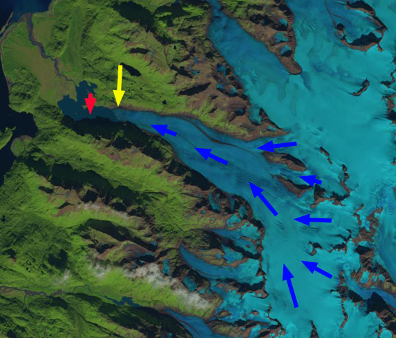
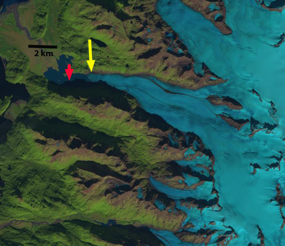
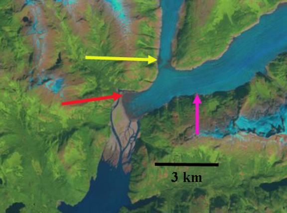
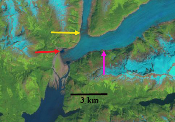
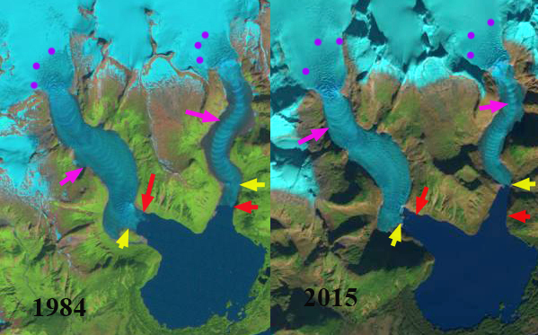
Landsat comparison of terminus area of Fingers Glacier 1986 and 2015

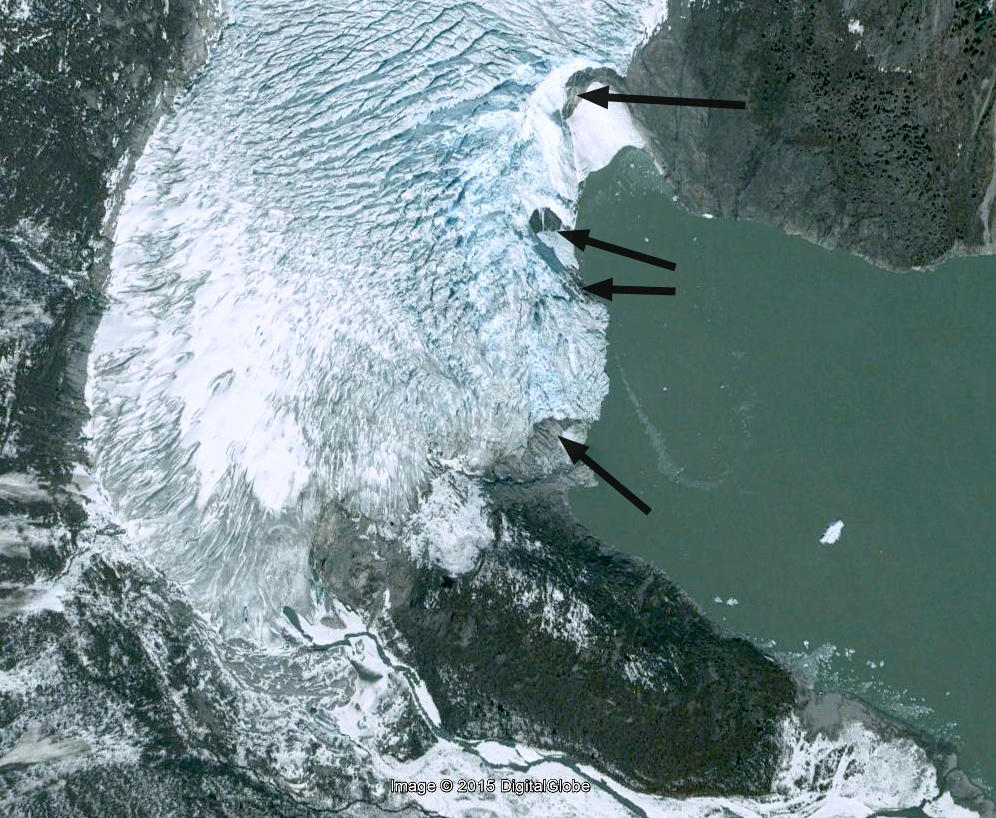
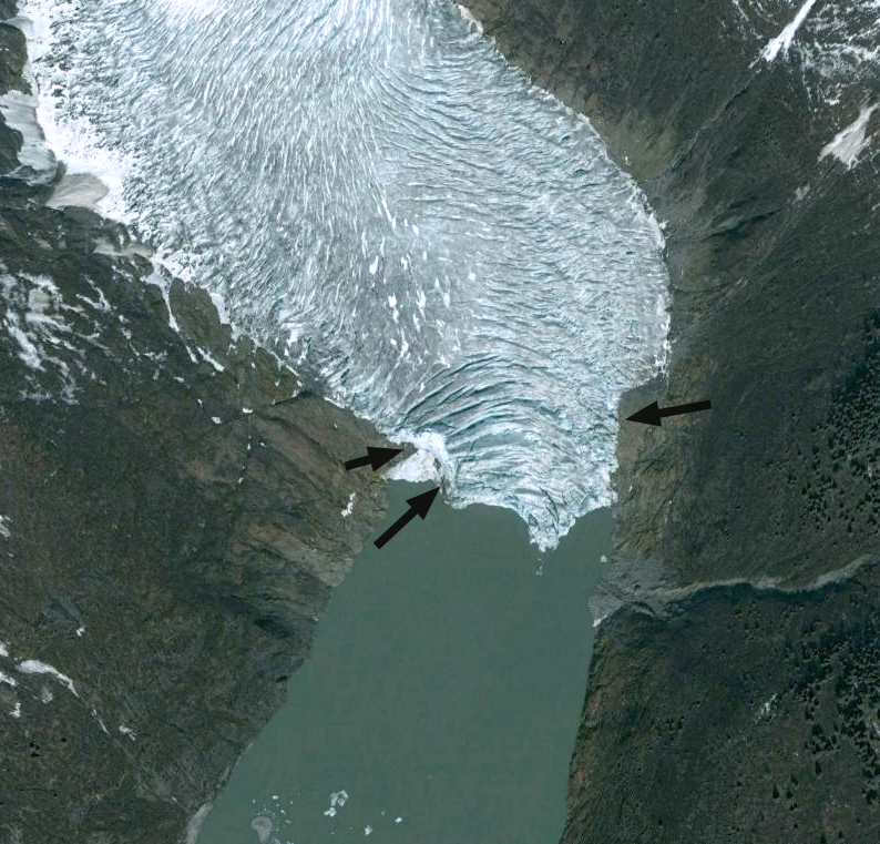
Fingers Glacier flows from the southern end of the Fairweather Range to the coastal plain, where is expands into a segmented piedmont lobe. The southernmost finger is heavily debris covered. In the Mount Fairweather B-4 quadrangle USGS map based on 1951 aerial photographs the glacier has four prominent fingers each eroding its own basin.  Here we examine Landsat imagery to illustrate the changes in this glacier from 1951 to 2015.  From 1950-1980  glacier’s just to the north In Lituya Bay were advancing. The La Perouse Glacier its immediate neighbor to the north was stable. Palma Glacier directly to the southeast has retreated throughout the 1950-2015 period.  Larsen et al (2015) identify that from 1994-2013 this region of Alaska is a significant source of glacier volume loss and hence contributor to sea level rise.  The loss of 75 gigatons per year from glaciers in southern Alaska was determined in this study to be largely from surface melt not from calving losses.  The mass balance of both Taku and Lemon Creek Glacier of the Juneau Icefield have had a notable decline in mean mass balance from 1986-2015 versus the 1951-28985 period (Pelto et al, 2013).  The nearby Brady Glacier also experience a higher snowline (Pelto et al, 2013b) which led to volume losses quantified by Larsen et al (2015).
fingers map

USGS map based on 1951 images

By 1986 the glacier still had four fingers with retreat from the 1951 position yellow arrow to the 1986 position red arrows.  Retreat was 900 m for the first finger, 400 m for the second finger, 300 meters for the third and 400 meters for the fourth southernmost finger.   A new lake had developed at the second finger, well lake expansion occurred at the first and third finger.  By 1999 a lake is beginning to form at the fourth finger.  In 2015 the first finger has retreated 600 meters in 30 years.  The second finger has disappeared after a 700 m retreat from 1986-2015..  The third finger has lost half of its length to the expanding lake, a retreat of 600 m in 30 years.  The fourth finger which is the most debris covered, leading to slower thinning, has retreated 600 meters since 1986, with a lake at the terminus that is continuing to expand.

fingers 1986

1986 Landsat Image

fingers 1999

1999 Landsat Image

fingers 2015

2015 Landsat Image
fingers glacier

Google Earth Image indicating flowlines.

Palma Glacier, Alaska Retreat Opens Lake Passage

Palma Compare
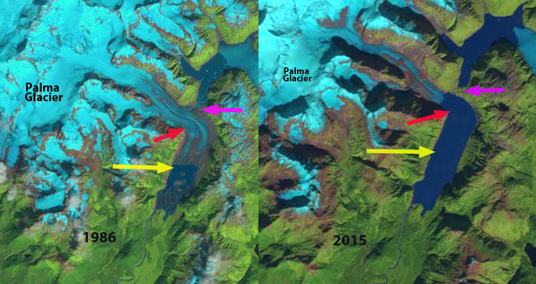
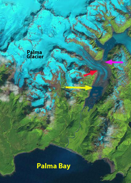
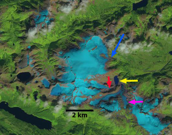
An August 1986 and September 2015 Landsat Image of Palma Glacier, 1986 terminus yellow arrow.
Palma Glacier is an unnamed glacier just west of Brady Glacier and Glacier Bay that is the principal glacier draining into Palma Bay.  Here we examined the changes in this glacier from 1986 to 2015 with Landsat Imagery.  The glacier has terminated in a lake at the head of a river draining into Palma Bay at least since the 1950 USGS map was prepared.The neighboring Brady Glacier advanced for much of the 20th century,  its tributary lobes began to retreat after 1970.  The main Brady Glacier terminus did not begin to retreat until 2009 and is poised to begin a rapid retreat as lake development at the terminus continues due to ongoing thinning (Pelto et al, 2013)..

palma glacier ge

Google Earth image of the Palma Bay and Palma Glacier region

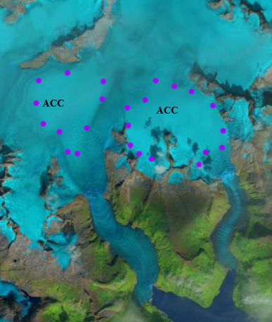
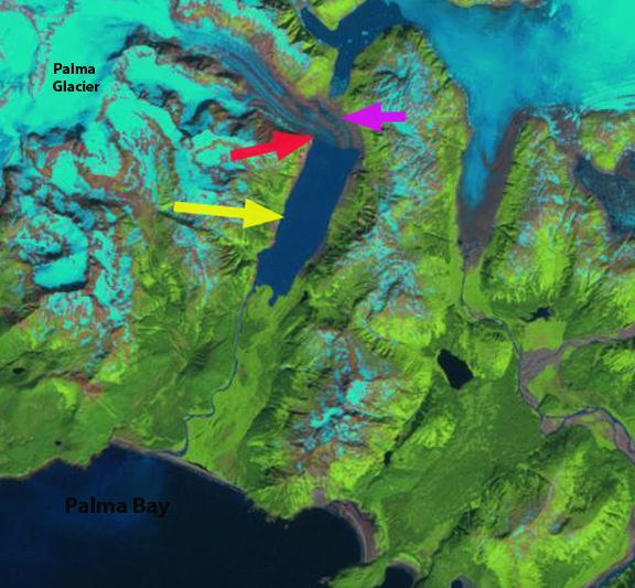
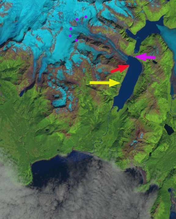
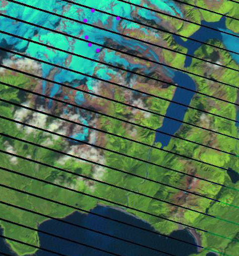
In 1986 Palma glacier flowed south out of the mountains before turning sharply west for 2 km before terminating in a lake at the yellow arrow. The lake had considerable debris covered ice bergs that had recently calved. By 1999 the glacier had retreated to the westward turn, red arrow, but did extend to the south side of the lake.  By 2014 the glacier had retreated from the westward turn, red arrow, and the strip of land between the two lakes at the purple arrow has been exposed and vegetated. it is now possible to paddle up one lake and portage to the next. The snowline purple dots is at 1000 m.  In 2015 this September image at top is after an early season snowfall, the last image below is an August image indicating the snowline is again at 1000 m with several weeks left in the melt season.  The glacier has retreated 2100 meters from 1986 to 2015 and still terminates in the lake. The retreat has slowed since 1999 after the lake narrowed at the westward turn. Retreat will continue as a snowline at 1000 m is to high to sustain even the current size of Palma Glacier.

palma Glacier1986
1986 Landsat image

palma glacier1999
1999 Landsat Image
palma glacier 2014
2014 Landsat Image
Palma snowline Aug 2015
2015 Landsat Image

Slender Glacier, Brooks Range, Alaska: Rapid Retreat 1992-2014

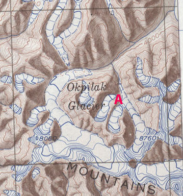
Slender Glacier is not an official name, but a well suited name to this glacier in the Romanzof Mountains of the Brooks Range of Northern Alaska.  It is adjacent to the Okpilak Glacier and drains into the Okpilak River, which is host to arctic grayling. Here we examine Landsat imagery from 1992-2014 to identify changes. U-Alaska-Fairbanks has an ongoing program in the nearby Jarvis Creek Watershed examining in part how will the anticipated future increase in glacier wastage and permafrost degradation affect lowland hydrology.  Matt Nolan (U-AK-Fairbanks) reports on changes of nearby McCall and Okpilak Glacier. These glacier have suffered increased mass loss since 1990 as a result of an increase in the equilibrium line altitude that has reduced accumulation area and is indicative of increased ablation (Delcourt al , 2008)

mt_michelson-1956
USGS 1951 map

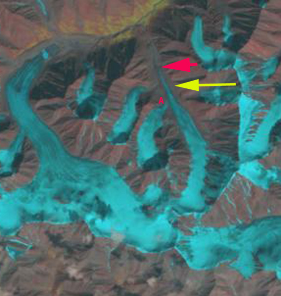
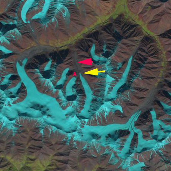
In 1992 the glacier extended downvalley to the red arrow at 1530 m. The glacier also received contribution from a tributary glacier at Point A. By 2002 the glacier had receded a short distance from the red arrow and still received input from the tributary glacier at Point A. By 2013 the glacier had receded to the yellow arrow 1100 meters from the 1992 terminus position, and now terminates at an altitude of 1675 m. The tributary glacier is no longer connected to Slender Glacier at Point A. The percent of snowcover is better than on Okpilak Glacier immediately to the west, or East Okpilak Glacier to the southeast. The first tributary entering the glacier on the east side is also disconnecting from Slender Glacier.   In 2014 the Landsat image is after a light snowfall that has endured only on the glacier ice, helping outline the glaciers. The continued decline in retained snowfall and contributed snowfall from tribuatry glaciers will lead to an even more slender glacier.

slender glacier 1992
1992 Landsat Image

slender glacier 2002
2002 Landsat Image

slender glacier 2013
2013 Landsat Image

slender glacier 2014
2014 Landsat Image

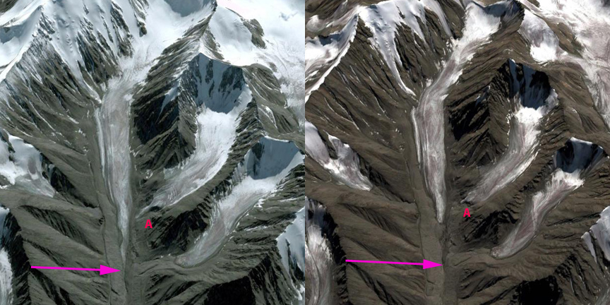
Google Earth images from 2006 and 2012 indicate a rapid retreat of the thin main terminus, and the loss of contact with the tributary glacier at Point A. The retreat is similar to that of Fork Glacier and Romanzof Glacier in the same region. The retained snowcover in 2012 is minimal on Slender Glacier and its tributaries. Tributary A lost almost all snowcover in 2012 and 2013 suggesting a lack of a consistent accumulation zone, which a glacier cannot survive without (Pelto, 2010)

slender comparison
2006 Google Earth Image and 2012 Google Earth image

Retreat of Grewingk Glacier, Alaska 1986-2014

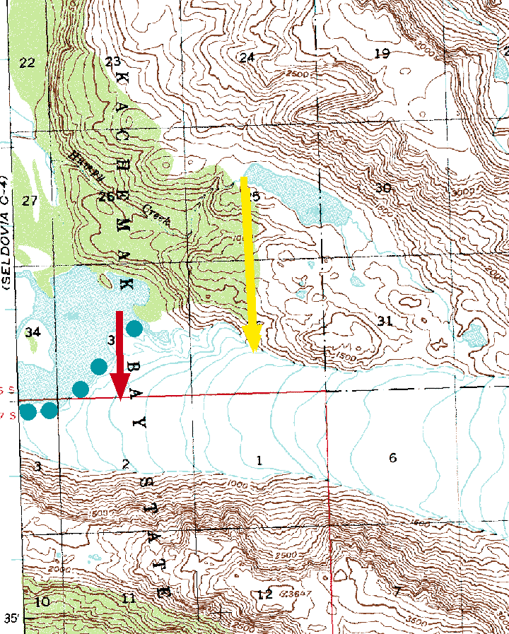
Grewingk Glacier drains west toward the Kachemak Bay, Alaska terminating in a proglacial lake in Kachemak Bay State Park.  The glacier drains an icefield on the Kenai Peninsula, glaciers draining west are in the Kenai Fjords National Park. The glaciers that drain east toward are in the Kenai Fjords National Park, which has a monitoring program.  Giffen et al (2008) observed the retreat of glaciers in the region. From 1950-2005 all 27 glaciers in the Kenai Icefield region examined  are retreating. Giffen et al (2008)observed that Grewingk Glacier retreated 2.5 km from 1950-2005.  Here we examine Landsat imagery from 1986-2014 to illustrate the retreat of the glacier.  The icefront continues to calve into the expanding pro-glacial lake.

grewingk map

1951 based USGS Topographic map Seldovia C-3

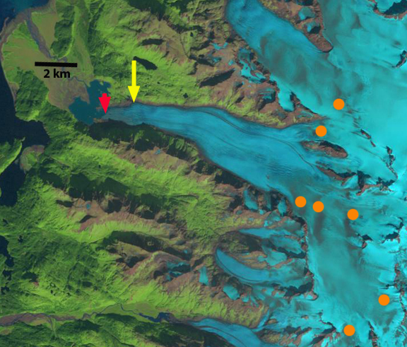
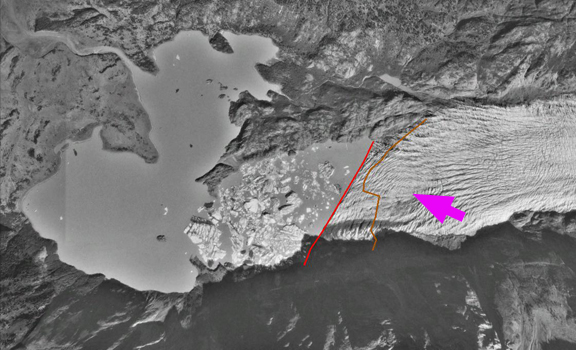
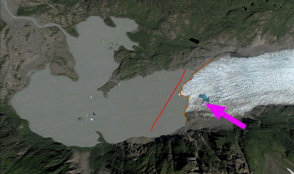
The red arrow is the 1986 terminus location at the midpoint, the yellow arrow is the 2014 mid-point terminus location. In 1951 the glacier extended beyond the peninsula at the red arrow into the wider portion of the lake. By 1986 the glacier had retreated into the narrow section of the lake extending east into the mountains, the southern margin of the terminus is further advanced than the northern margin.  The orange dots indicate discoloration of the glacier surface from volcanic ash deposited on the glacier surface from Augustine Volcano in 1986. In 1989 there is not a marked change. In a 1996 Google Earth image, there is considerable icebergs indicating a recent collapse of a section of the terminus. The pink arrow indicates concentric crevasses, indicating a depression, the red line is the terminus in 1996 and the brown line the 2003 terminus.

By 2001 the terminus has retreated m, and the glacier front is now oriented north-south across the lake. In 2003 the depression from 1996 now has a small supraglacial lake, the terminus has retreated 500 m on the southern margin and 200 m on the northern margin. In 2013 the glacier has retreated an additional 600 m and the southern margin has now receded further upvalley than the northern margin. Blue arrows indicate direction of glacier flow.  By 2014 the glacier has retreated 1.4 km since 1986, 50 m per year. There is an increase in the glacier slope 2.5 km above the terminus where crevassing increases.  This suggests the lake will end by or at this point, which would then lead to a reduction in retreat rate.

This retreat follows that of Pederson Glacier, Four-Peaked Glacier and Spotted Glacier. The continued reduction in glacier size leads to changes to the Kachemak Bay estuary. Kachemak Bay is the largest estuarine reserve in the National Estuarine Research Reserve System. It is one of the most productive, diverse estuaries in Alaska, with an abundance of Steller sea lions, seals, sea otters, five species of Pacific salmon, halibut,herring, dungeness crabs and king crabs (NERRS, 2009). The estuary salmon fishing industry is, one of Kachemak Bay’s most important resources and livelihoods.

grewingk Glacier 1986a
1986 Landsat Image

Grewingk 1989
1989 Landsat Image

grewingk 1996 ge
1996 Google Earth Image

grewingk glacier 2001
2001 Landsat Image

grewingk 2003 ge
2003 Google Earth Image

grewingk glacier 2013a
2013 Landsat Image

grewingk glacier 2014
2014 Landsat Image


Widespread Retreat Gilkey Glacier System, Alaska

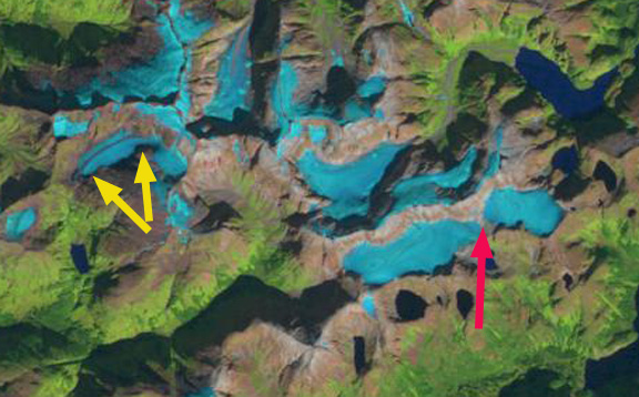
Gilkey Glacier drains the west side of the Juneau Icefield and has experienced widespread significant changes since I first worked on the glacier in 1981.    Here we examine the changes from the August 17, 1984 Landsat 5 image to the August 21, 2014 image from newly launched Landsat 8.  Landsat 5 was launched in 1984, Landsat 8 launched in 2013. The Landsat images have become a key resource in the examination of the mass balance of these glaciers (Pelto, 2011). The August 17th 1984 image is the oldest Landsat image that I consider of top quality. I was on the Llewellyn Glacier with the Juneau Icefield Research Program (JIRP) on the east side of the icefield the day this image was taken. JIRP was directed by Maynard Miller at that time and by Jeff Kavanauagh now. The Gilkey Glacier is fed by the famous Vaughan Lewis Icefall at the top of which JIRP has its Camp 18 and has monitored this area for 60 years. Here I examine changes both in images and text below. The same analysis in a more depth is contained in the screen capture video of the same images.  Choose the format you prefer and let me know which works for you.

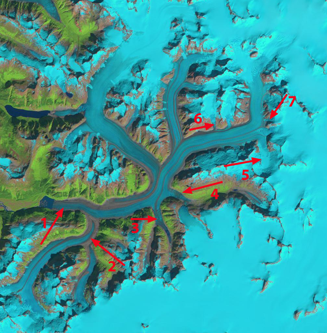
There are seven locations noted in the 1984 and 2014 image that are the focus of more discussion in a set of three more focused images

gILKEY gLACIER 1984 SOURCE

1984 Landsat Image

Gilkey Glacier 2014 source

2014 Landsat image

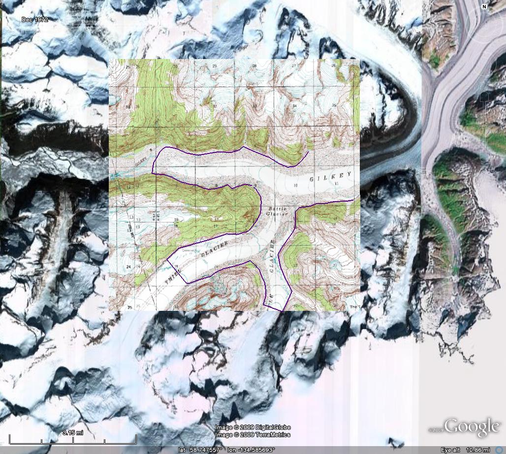
Arrow #1 indicates the Gilkey Glacier terminus  area.  Gilkey Glacier had begun to retreat into a proglacial lake by 1984, the lake was still just 1 km long. A short distance above the terminus the Gilkey was joined by the sizable tributaries of the Thiel and Battle Glacier. By 2014 the main glacier terminus has retreated 3200 m, the lake is now 4 km long.  A lake that did not exist in USGS maps from 1948. Thiel and Battle Glacier have separated from the Gilkey Glacier and from each other. Thiel Glacier retreated 2600 m from its junction with Gilkey Glacier from 1984-2014 and Battle Glacier 1400 m from its junction with Thiel Glacier and 3500 m from the Gilkey Glacier.  Melkonian et al (2013) note the fastest thinning in the Gilkey Glacier system from to is near the terminus and in the lower several kilometers of Thiel Glacier.

Gilkey terminus retreat

Above: 1984-2014 Comparison of Gilkey Glacier terminus area with Landsat imagery

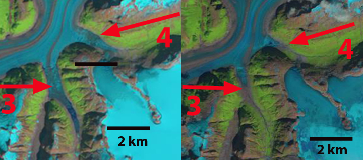
Arrow #3 and #4 indicates valleys which tongues of the Gilkey Glacier flow into.  In 1984 at #3 the glacier extended 1.6 km upvalley ending where the valley split. The portion of the Gilkey flowing into the valley had a medial moraine in its center.  At arrow #4 the glacier extended 1.5 km up Avalanche Canyon.  In 2014 at  #3 the glacier tongue ends 1.2 km from the valley split, and the medial moraine does not enter the valley.  At #4 the glacier has retreated 1.3 km, leaving this valley nearly devoid of a glacier.

avalanche canyon retreat

Above: Comparison of the Avalanche Canyon area 1984-2014.

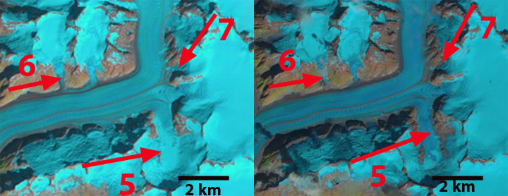
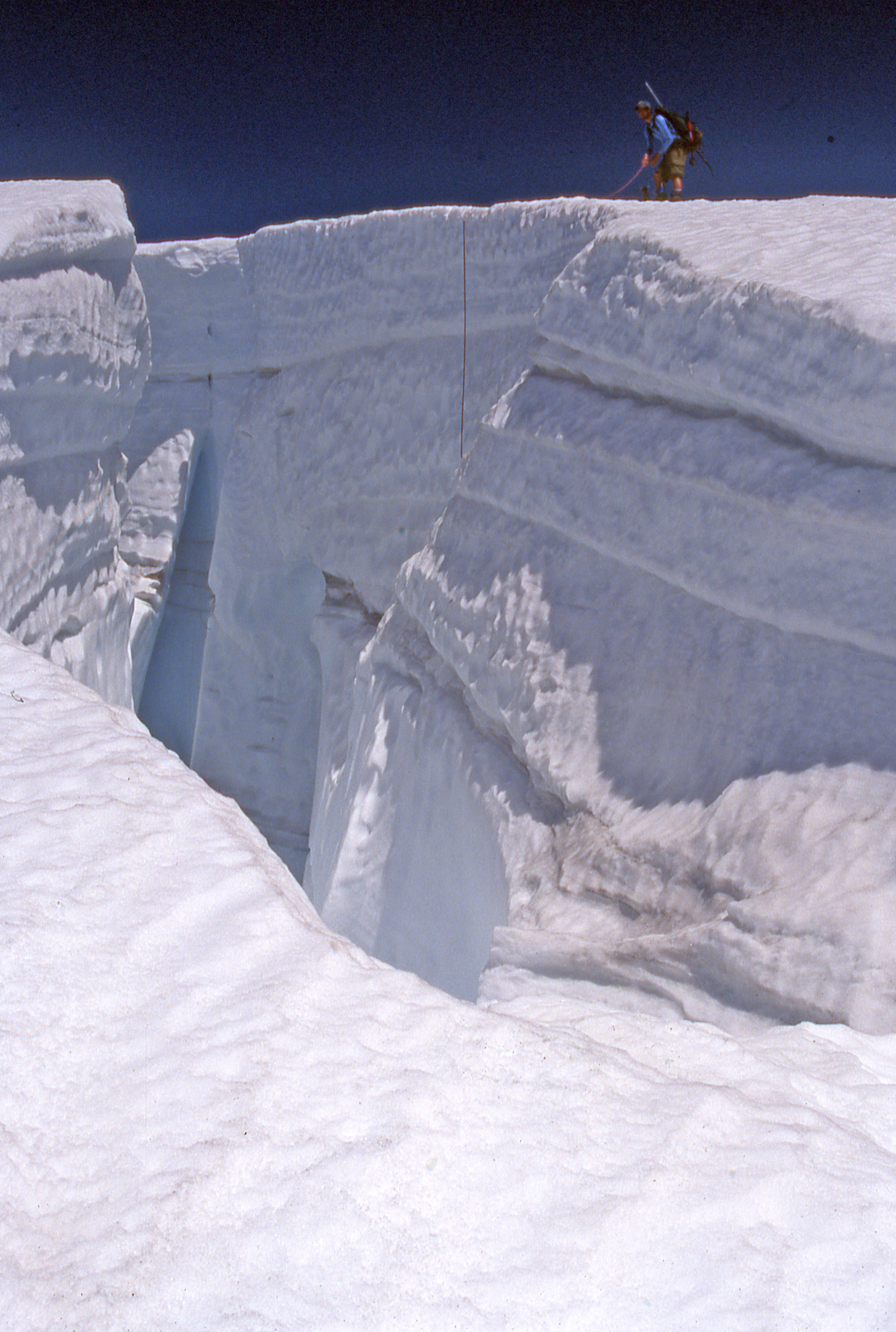
Further upglacier arrow #5 indicates a side glacier that in 1984 featured an unending system of glacier flowing down the steep mountain sides into the valley bottom.  By 2014 two rock ribs extend along most of the east and west valley walls separating the glaciers on mountain side from the main valley glacier, which has as a result been reduced in width and velocity. At arrow #6 a tributary glacier is seen merging with Gilkey Glacier in 1984.  By 2014 this tributary no longer reaches the Gilkey Glacier, ending 300 m up the valley wall.  At arrow #7 the Little Vaughan Lewis Icefall in 1984 is seen merging with the Gilkey Glacier across a 300 m wide front.  This I can attest from seeing the glacier that summer to be an accurate observation.  By 2014 at arrow #7 the Little Vaughan Lewis Icefall no longer feeds ice directly to the Gilkey Glacier.  There is still avalanching but not  a direct flow connection. JIRP has Camp 19 in this area, a spectacular area of ongoing research by JIRP.   The main Vaughan Glacier Icefall is still impressive, just south of the rib beyond arrow #7. Measurements of snowpack are made annually by JIRP above the icefall, and indicate a mean snow depth exceeding 3 m in early August, note image below of measuring annual snow layers in a crevasse at head of the icefall. Pelto et al (2013) summarize the results of this ongoing research that Chris McNeil (USGS) is working to enhance with newer technology.  The terminus change of all Juneau Icefield glaciers from 1984-2013 has been summarized in a previous post. The 2015 season will be of interest, since the area had a remarkably warm yet wet winter.  This will lead to high ablation at lower elevations, likely a higher snowline than usual, but above the Vaughan Lewis Icefall will those warm wet events dumped snow? The 2014 winters season was warm and the snowline seen in the 2014 satellite imagery was at 1500 m, yet snowpack at 1760 m on the Vaughan Lewis Glacier was 3.3 m deep in late July.  This has been the case in the past with warm wet winters featuring heavy snow above 1600 meters on the icefield. JIRP will be in the field answering this question in 2015.
little vaughan

Above: Comparison 1984-2014 of the Vaughan Lewis Glacier area

Untitled-24

Crevasse stratigraphy Vaughan Lewis Glacier.

Mahsa Icefield Retreat and Separation, Baranof Island, Alaska

The Mahsa Icefield is at the headwaters of Takatz Creek.  This is a small glacier, not an actual icefield.  Five kilometers to the west is another small unnamed glacier at the headwaters of Sawmill Creek.  Here we focus on changes in the two glacier using Landsat images from 1986 to 2014.mahsa icefield ge

Google Earth image

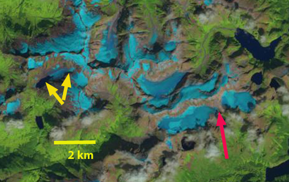
In 1986 the Mahsa Icefield is a contiguous glacier that extended 5 km from east to west, red arrow indicates  the mid-section of the icefield.  A separate glacier in Sawmill Creek, yellow arrows, was 2.1 km long and has no lake at its terminus.  In 1997 the Mahsa Icefield has separated into an east and west half, at the red arrow, and has lost all of its snowcover.  The glacier in Sawmill Creek is still a single ice mass, but has lost all of its snowcover, which happened in 1998, 2003 and 2004. In 2014 the Mahsa Icefield’s east and west half are separated by 300 m, red arrow.  There is very little snowcover remaining despite there is a month left in the melt season.  At the headwaters of Sawmill Creek a lake has formed as the glacier has retreated, the lake is 600 m long in 2014.  The glacier has also separated into a small upper and lower section.  This glacier has lost half of its area since 1986.  The retreat of these glaciers on Baranof Island is similar to the retreat of nearby Carbon Lake Glacier,Lemon Creek Glacier, and Sinclair Glacier. Lemon Creek Glacier has lost more than 25 m of glacier thickness during the 1953-2014 period when its mass balance has been observed by the Juneau Icefield Research Program, and has retreated more than 1 km (Pelto et al, 2014).

mahsa icefield 1986

Landsat image 1986

mahsa icefield 1997

Landsat Image 1997

mahsa icefield 2014

Landsat image 2014


Carbon Lake Glacier Retreat, Alaska

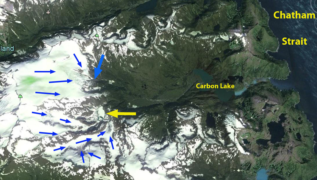
On Baranof Island in southeast Alaska there are a pair of unnamed glaciers at the headwaters of the Carbon Lake watershed, that then drains into Chatham Strait.  Here we examine changes in these glacier from 1986 to 2014 using Landsat imagery.  The blue arrow indicates the northern glacier terminus and the yellow arrow the southern glacier terminus region.

carbon lake ge

In 1986 the southern glacier terminus, yellow arrow consisted of three main tributaries combining to form a low sloped terminus region.  The northern glacier had a single terminus.  By 1997 a lake has formed at the southern glacier, which now has two separate termini, the red arrow indicates a new terminus area and the pink arrow the eastern portion of this glacier.  The northern glacier, blue arrow, is retreating but still joined.  By 2014 the southern glacier has separated into three parts.  There is a terminus at the red arrow, this represents a 900 m retreat since 1986.  This portion of the glacier has further separated since 1997 into two parts.  The eastern glacier, pink arrow has retreated 700 m since 1986.  The new alpine lake is 600 m long.  The northern glacier, blue arrow, has separated into two main termini and the glacier has retreated 200 m.   The retreat of these glaciers paralells the observed losses of other smaller glacier in the region most notably Lemon Creek Glacier, which is a World Glacier Monitoring Service reference glacier, 30 km west on the edge of the Juneau Icefield.  Another nearby example is Sinclair Glacier.  Lemon Creek Glacier has lost more than 25 m of glacier thickness during the 1953-2014 period when its mass balance has been observed by the Juneau Icefield Research Program, and has retreated more than 1 km.

carbon lake 1986
1986 Landsat image Carbon Lake Glaciers
carbon lake 1997
1997 Landsat image Carbon Lake Glaciers
carbon lake 2014
2014 Landsat image of Carbon Glacier


Shakes Glacier Retreat-Tributary Separation, Alaska

Shakes Glacier drains the southern portion of the Stikine Icefield and terminates in Shakes Lake. It is between the more famous LeConte Glacier to the west and Great Glacier to the east. Larsen et al (2007) indicate recent thinning of 2-4 meters per year on the glaciers along the southern margin of the Stikine Icefield. Here we utilize 1985-2013 Landsat imagery to examine changes in this glacier. shakes overall

The USGS map of Shakes Glacier indicates the glacier turning the corner south along Shakes Lake. In each image the red arrow marks the 1986 terminus, the yellow arrow the 2013 terminus, the pink arrow a tributary from the east and the purple arrow a tributary from the west. shakes mapIn 1985 and 1986 the glacier has retreated onto the southeast trending arm of the lake ending at a deep gully on the west side of the lake, red arrow. The tributaries are still well connected to the glacier. By 1993 the glacier has retreated 300 m, the east tributary is still well connected, the west tributary at the purple arrow has considerably diminished. By 2003 the terminus has retreated 1.2 km from the 1985 position, the west tributary is just separating from the main glacier. The snowline is nearly at the top of the west tributary with a month left in the melt season. By 2011 a Google Earth image indicates the loss of connection with the west tributary and the disconnection on the east side which ends in a steep icefall slope. There is also a lake, green arrow just behind the terminus indicating impending rapid retreat will continue. The 2013 Landsat image the terminus has retreated 2.2 km from 1985, that is 78 meters/year. The lake is still evident behind the terminus. The continued significant retreat of Shakes Glacier matches that of other glaciers in the area Great Glacier, Baird Glacier, Patterson Glacier and Sawyer Glacier. shakes 1985
1985 Landsat image

shakes 1986
1986 Landsat image

shakes 1993
1993 Landsat image

shakes 2003
2003 Landsat image

shakes ge
2011 Google Earth image

shakes 2013
2013 Landsat image

Baird Glacier Retreat Initiation, Alaska

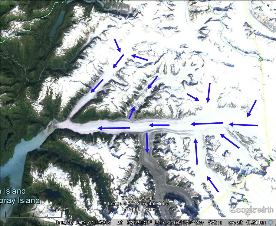
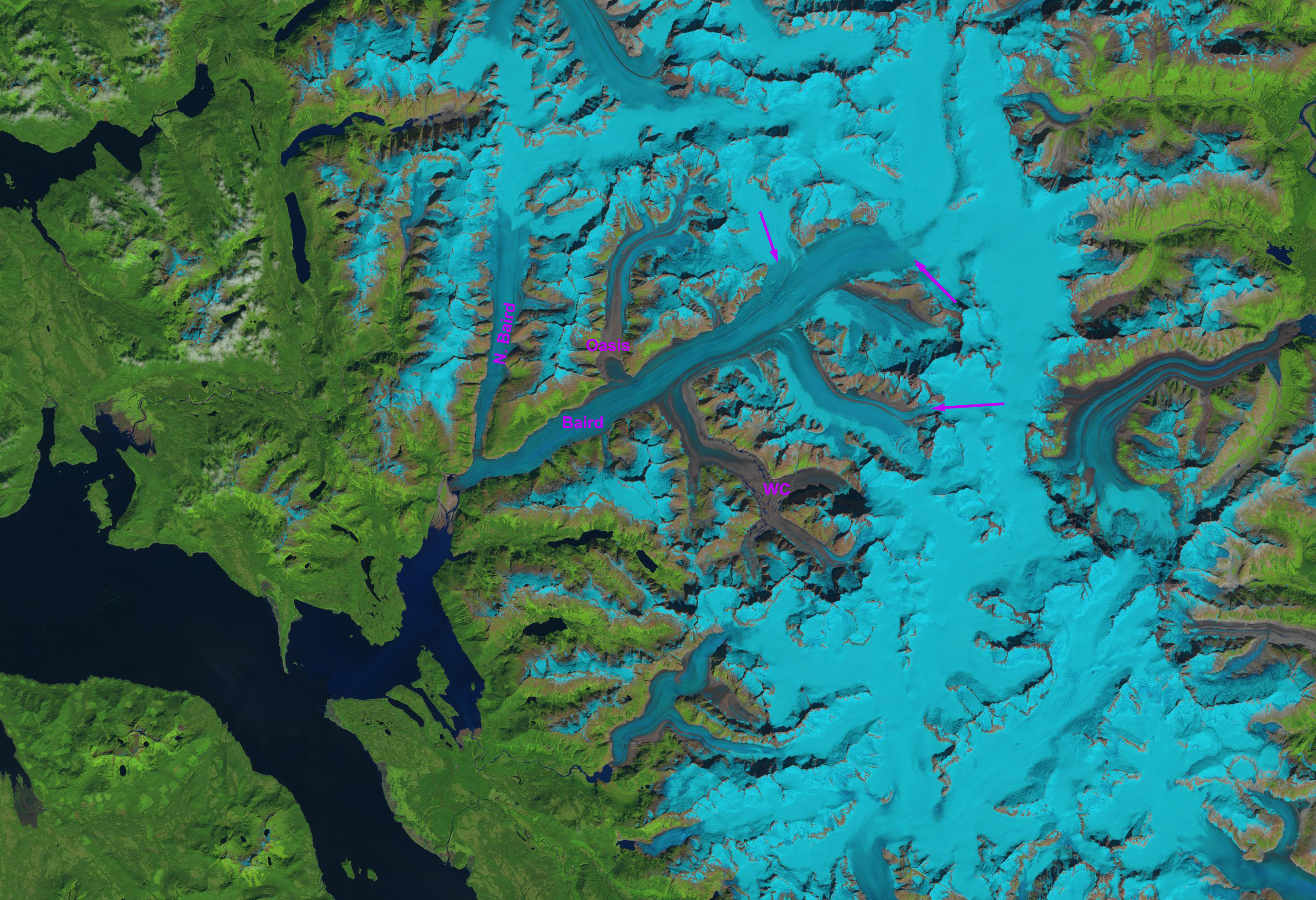
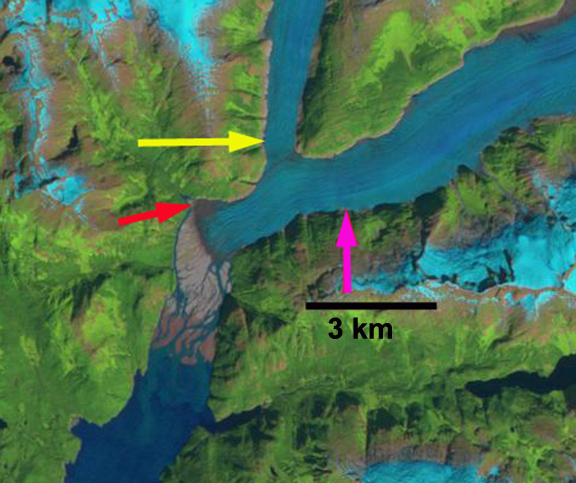
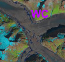
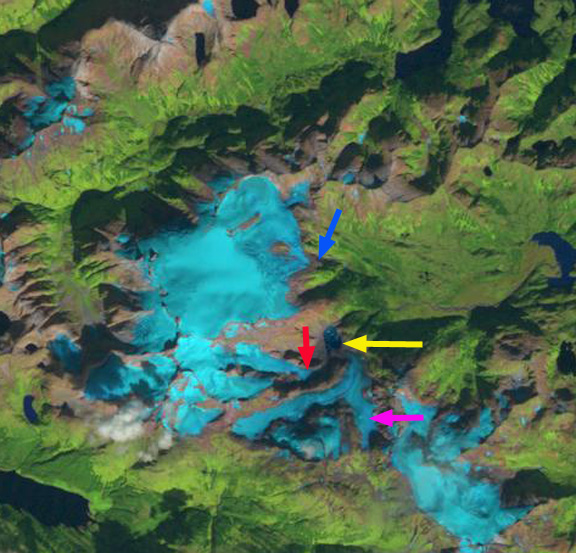
Baird Glacier drains the west side of the Stikine Icefield in southeast Alaska. It is the only glacier of the Stikine Iceifield that has not retreated significantly since 1960. This is similar to the Juneau Icefield where only the Taku Glacier has not retreated. From 1887 to 1941, the advance totaled about 1 km and from 1941-1980 it advance another kilometer. The terminus had not changed from 1980-2010. In 1984 I had a closeup look at the terminus, it was heavily debris covered and lacked crevassing. This indicated a limited velocity, yet the ice was clearly quite thick, and it would take considerable melting to initiate retreat. In this post we examine Landsat images from 1990, 2005 and 2013 to see how the terminus is responding to climate change. The blue arrows indicate the glacier flow in the Barid Glacier System. Just above the terminus the main Barid Glacier is joined by the North Baird Glacier. About 15 km upglacier of the terminus are two glaciers Witches Cauldron (WC) to the south and Oasis to the north that the Baird Glacier is flowing into instead of being fed by them. This has been the case for sometime. The purple arrows indicate the 2013 snowline near the end of the melt season is at 1300 m. This is high and will lead to a negative mass balance and volume loss for the glacier in 2013.baird glacier ge copybaird glacier landsat8 In 1990 the Baird Glacier is sitting on an outwash plain, with no lake at the terminus. The North Baird Glacier was 1100 meters wide at the yellow arrow, just before joining the Baird Glacier . The main Baird Glacier is 1350 m wide at the pink arrow. By 2005 the North Baird Glacier is 900 m wide at the yellow arrow, and the Baird Glacier 1200 m wide at the pink arrow. The terminus appears unchanged in 2005. By 2013 the North Baird Glacier is just 700 m wide at its junction at the yellow arrow and the Baird Glacier just 1100 m wide at the pink arrow. The narrowing of both indicates less ice flow to the terminus, which will lead to retreat. In 2013 two lakes have appeared at the terminus, red arrow. The terminus has begun a measurable retreat, the lakes are 400-600 m across indicating. There will be a continued expansion of these two lakes and a significiant retreat of the main terminus will ensue. This will lead to the separation of the North Baird and Baird Glacier. Upglacier in the Witches Cauldron a series of supraglacial lakes have begun to form as well. Larsen et al (2007) using repeat laser altimetry note that North Baird Glacier in its lowest 10 km from the junction with Baird Glacier was losing 2 m per year in ice thickness. From 2000-2009 the thinning rate is even higher, with Baird Glacier main trunk losing 10-20 m in thckness in the lowest 20 km Larsen et al (2009). Baird Glacier is joining the rest of the Stikine Icefield is already in retreat, Sawyer Glacier, Patterson Glacier and Great Glacier.
barid glacier 1990

baird glacier 2005

baird 2013

witches cauldron

Gilkey Glacier Ogive Spacing and Retreat

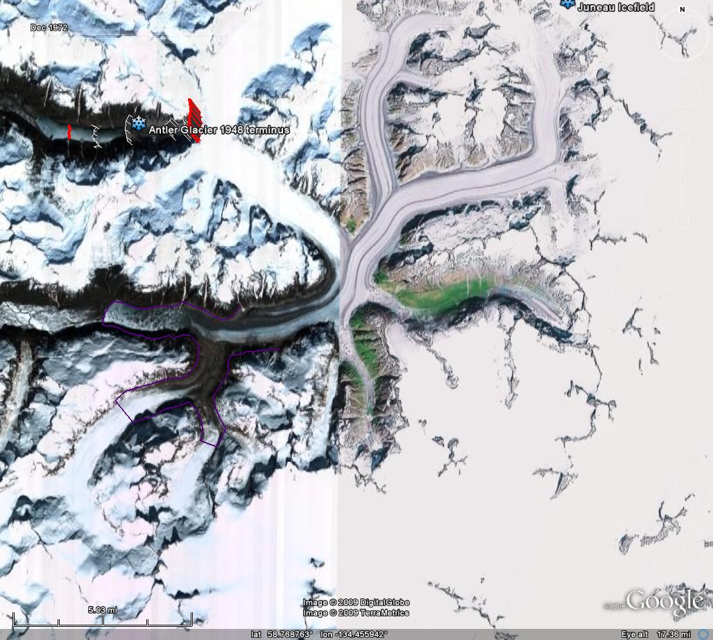
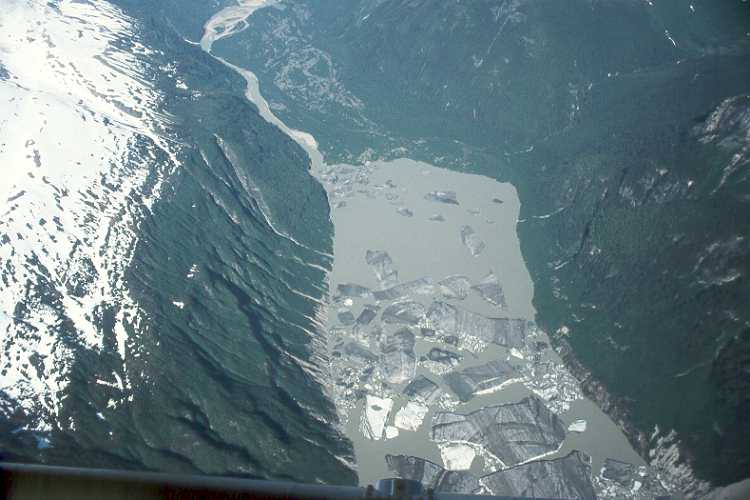
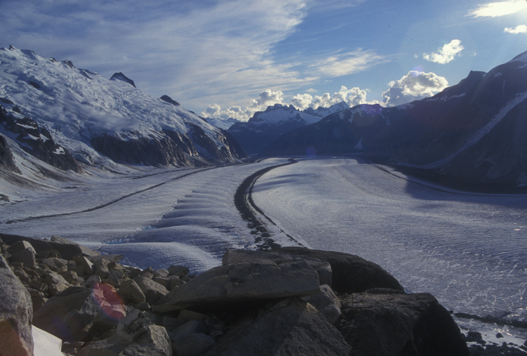
The Gilkey Glacier is a 32 km long outlet glacier flowing west from the Juneau Icefield. From 1948 to 1967 the Gilkey Glacier retreated 600 m and in 1961 a proglacial began to form. By 2005 Gilkey Glacier has retreated 3900 m from the 1948 terminus location. The glacier is currently terminating in this still growing lake, notice the new bergs and rifting at the glacier terminus. The retreat has been resulted from and in a thinning of in the lower reach of the glacier and the separation from Battle and Thiel Glacier. A major tributary to Gilkey Glacier, is Vaughan Lewis Glacier. At the base of the Vaughan Lewis Icefall where the Vaughan Lewis Glacier joins the larger Gilkey Glacier ogives form, as seen from above and below the icefall (Scott McGee). The ogives form annually and provide a means to assess annual velocity in this section of the glacier. Aerial photography of the ogives from the 1950’s combined with current satellite image provide the opportunity to assess ogive wavelength over a 50 year period, providing a long term velocity record for Gilkey Glacier. An ogive is a bulge-wave that forms annually due to a seasonal acceleration of the glacier through an icefall. The acceleration is enhanced in icefalls that are horizontally restricted. In most cases we do not have specific measurements of velocity through all season to ascertain the timing of the accelerated period, though typically spring would be the fastest. After formation the bulges move down glacier and a new bulge is formed the following year. The resulting train of ogives extending down glacier can be used to estimate the ice velocity by measuring the peak to peak separation between adjacent waves. Ogives can be visually identified as a series of arcuate wave crests and troughs pointing down glacier. Downglacier from this formation point the crests and troughs gradually flatten until the ogives are merely arcuate light and dark bands on the surface of the glacier. The dark bands are dense, blue and dusty ice that is compressed during summer, whereas the light bands are bubbly, white, air-filled ice that is compressed during winter.
In 1981 one of my tasks was to ski out through the top of the icefall inserting stakes in the crazily crevassed region to track summer velocity for the Juneau Icefield Research Program (JIRP). This has been completed often but not most years by JIRP. What we discovered was that velocity in 1981 had not changed from the 1960’s and 1970’s. Today we have frequent satellite imagery of the ogives to ascertain annual velocity that can be compared to the few aerial photographic records, in this case from 1056 and 1977. In several recent years Scott McGee of JIRP has specifically surveyed the distance between the first 11 ogive crest below the icefield. A comparison of the the ogives in 1956, 1977 and 2005 is possible by overlaying the images below. . The distance from the first to the 40th ogive has gone from 6.8 km in 1956 to 6.75 km in 1977 to 6.2 km in 2005. In 1956 and 1977 the first ten ogives spanned 1500 meters indicating an annual glacier velocity of 150 meters. From 2003-2007 the distance of the first ten ogives averaged 1440 m, or 144 meters per year. The change in velocity is quite small, compared to the large retreat of the glacier. One other key measure of the ogive surveying program is the surface elevation. A longitudinal profile containing 179 survey points was established at the base of the Icefall in 2001-2007. This profile begins in the trough immediately upglacier of the crest of the first wave ogive and continues downglacier nearly 1.8 kilometers to a point where the amplitude of the ogives becomes zero (Graphs and data from JIRP) During this six year time period, the surface has lowered an average of 17 meters – nearly 3 meters per year – along the longitudinal survey profile, with a maximum of 22 meters. This substantial thinning at the base of the icefall indicates reduced discharge through the icefall from the accumulation zone above. This will lead to further retreat and velocity reduction of Gilkey Glacier.