Bailang Glacier and Angge Glacier Retreat, China 1995-2015

bailang compare

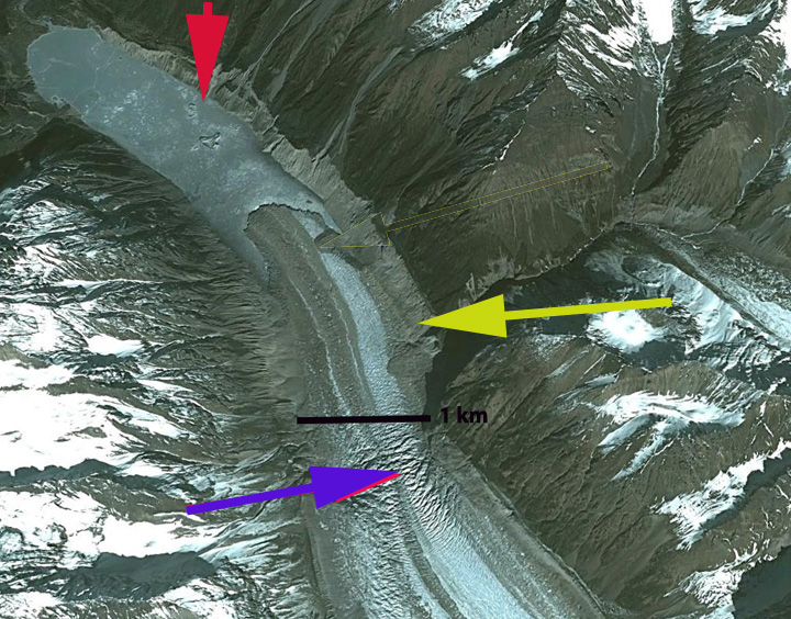
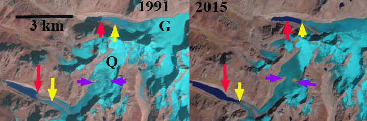
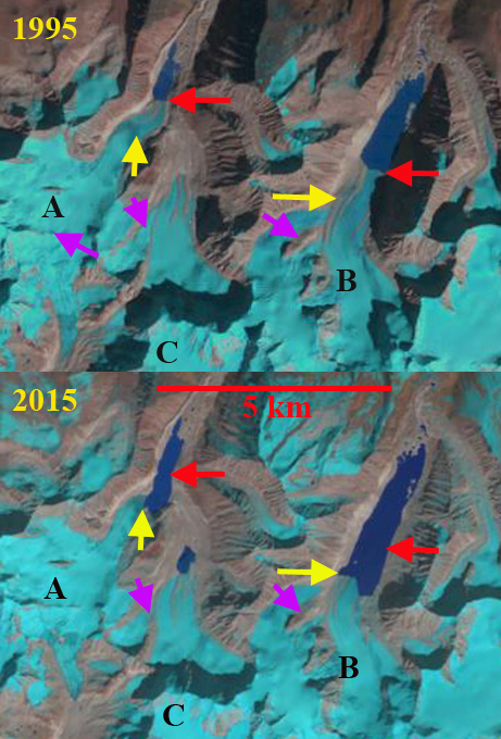
Comparison of 1995 and 2015 Landsat image illustrating 1995 (red arrows) and 2015 terminus locations (yellow arrows) of Bailang Glacier (B) and Angge Glacier (A).  Purple arrows indicate areas upglacier of expanding bedrock due to glacier thinning. Head of Chubda Glacier (C), Bhutan indicated. 

Bailang Glacier and Angge Glacier, China are adjacent to the Chubda Glacier, Bhutan.  Despite being in a different nation on a different side of the Himalaya, the behavior is the same. These are both summer accumulation type glaciers that end in proglacial lakes.  Both lakes are impounded by broad moraines that show no sign of instability for a potential glacier lake outburst flood. The number of glacier lakes in the adjacent Pumqu Basin to the west has increased from 199 to 254 since the 1970’s with less than 10% deemed dangerous  (Che et al, 2014) Here we compare Landsat images from 1995 and 2015 to identify their response to climate change.   The second Chinese Glacier inventory (Wei et al. 2014) indicated a 21% loss in glacier area in this region from 1970 to 2009.

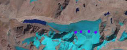
Bailang Glacier in 1995 terminated in a proglacial lake that was 2.1 km long at an elevation of ~5170 m, red arrow. Angge Glacier terminated in a lake that was 1 km long at an elevation of ~5020 m.  By 2001 both glaciers had experienced minor retreat of less than 250 m.  By 2014 both lakes had expanded considerably due to retreat, no significant change in water level had occurred. By 2015 Bailang Glacier had retreated  800-900 m and the lake was now 3 km long.  A key tributary on the west side near the yellow arrow had also detached. There is no significant slope change in the lower 1 km of the glacier indicating retreat should continue enhanced by melting in and calving in the proglacial lake.  For Angge Glacier retreat from 1995 to 2015 was 700 to 800 m, with the glacier retreating to a westward bend in the lake basin.  The glacier has an icefall just above the current terminus suggesting the lake basin will soon end, which should slow retreat. The pattern of retreat and lake expansion is quite common as is evidence by Gelhaipuco, Thong Wuk and Longbashaba Glacier.

bailang glacier 2001

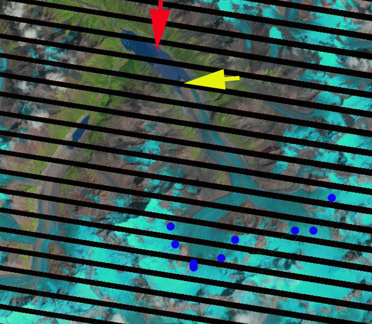
2001 Landsat image illustrating 1995 (red arrows) and 2015 terminus locations (yellow arrows) of Bailang Glacier (B) and Angge Glacier (A).  Head of Chubda Glacier (C), Bhutan indicated. 

bailang glacier 2014

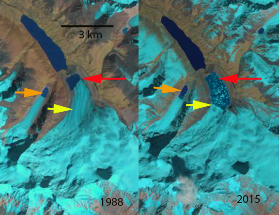
2014 Landsat image illustrating 1995 (red arrows) and 2015 terminus locations (yellow arrows) of Bailang Glacier (B) and Angge Glacier (A).  Head of Chubda Glacier (C), Bhutan indicated. 


Jiongla Glacier, China Rapid Retreat 1988-2015

jionla compare

Jiongla Glacier retreat right and Jiangyegong Glacier left retreat from 1988 to 2015 in Landsat images.  The red arrow is the 1988 terminus and the yellow arrow the 2015 terminus. Jiongla Glacier retreated 3200 m and Jiangyegong Glacier 800 m. 

Jiongla Glacier is at the northern boundary of the Brahmaputra River Basin at the east end of the Nyainqentanglha Shan. The glacier drains the western slopes of Koma Kangri Peak and ends in a lake before feeding into the Parlung Zangbo and then Yarlung Tsanpo. his glacier feeds the Parlung Zangbo which is the site of numerous planned hydropower projects, last image, before joining the Yarlung Tsanpo which becomes the Brahmaputra River. The Zangmu Dam went online in 2015, this hydropower facility will produce 2.5 billion kilowatt-hours of electricity a year. In a study by Tobias Bolch et al (2010) in the western Nyainqêntanglha Mountains glacier area decreased by 6% between 1976 and 2001 and continued to shrink from 2001–2009. Li et al (2010) examined glacier change over the last several decades in China and found ubiquitous glacier retreat and commonly lake formation as glaciers retreated. Ninglian and Shichang (2014) in the China National Report on Cryospheric Sciences noted a loss in glacier area of 15 to 17 % in the region. Here we examine satellite imagery from 1988, 2000, 2009, 2010, 2011 and 2015. The red arrow denotes the 1988 terminus and the yellow arrow the 2011 terminus.

In 1988 the lake where Jiongla Glacier ends is at 2 km long. By 2000 the glacier has retreated 1300 meters. In the 2003 terminus closeup that indicates vigorous flow through an icefall, purple arrow, 2 km behind the terminus. This indicates the lake will end before this point and the glacier does not have a substantial stagnant terminus tongue. By 2011 the lake is 4 km long, a 2 km retreat in 20 years. There are icebergs visible in the lake particularly in the 2003, 2009 and 2011 images indicating that this one a key reason for rapid recent retreat. In reviewing the satellite images for the region cloud cover made it difficult to find imagery near the end of the melt season. By 2015 the lake is 5200 m long indicating a 3200 m retreat from 1988-2015.  The terminus is now within 500 of the increase in surface slope that suggests the end of the lake, and likely the end of the current rapid retreat. The 2011 image is from near the end of the melt season and indicates a snowline at 5150 m, blue dots, this is too high for equilibrium, with limited glacier area above 5500 m and the terminus at 4000 meters. This suggests that retreat will continue.   The retreat here is similar to that of Thong Wuk Glacier and Requiang Glacier.

The neighboring Jiangyegong Glacier has experienced an 800 m retreat from 1988 to 2015.  This terminus remains low slopes and heavily debris covered. The debris will slow the retreat, while the low slope indicates the lake can continue to expand enhancing retreat.  This also suggests the rate of retreat will soon slow.T
jiongla2000

Landsat image 2000 with the yellow arrow indicating the 2011 terminus position and the red arrow the 1988 terminus position.

jiongla terminus2003 Google Earth Image

jiongla 2011

Landsat image 2011 with the yellow arrow indicating the 2011 terminus position and the red arrow the 1988 terminus position.


Yarlung Tsangpo HPP

Hydropower dams completed, under construction and proposed. 


Thong Wuk Glacier Terminus Tongue Collapse, China

sepu compare

Thong Wuk Glacier  comparison in 1988 and 2015 Landsat image.  Red arrow is the 1988 terminus location, yellow arrow the 2015 terminus location and orange arrow indicates expanding lake of Yanglang Glacier. 

There are two glaciers that drain the north side of Sepu Kangri Peak in the Eastern Nyainqêntanglha Mountains of Tibet in China. Thong Wuk to the east and Yanglang Galcier to the west. Most of the peaks in East Nyainqêntanglha Mountains are unclimbed, Sepu Kangri the highest peak was not climbed until 2002. The Sepu Kangri glaciers drain into the Salween River. In a study by Tobias Bolch et al (2010) in the western Nyainqêntanglha Mountains glacier area decreased by 6% between 1976 and 2001 and continued to shrink during the period 2001–2009. Li et al (2010) examined glacier change over the last several decades in China and found ubiquitous glacier retreat and commonly lake formation as glaciers retreated.

In this case we compare Landsat images from 1988, 2003, 2010 and 2015 and Google Earth images from 2011. In 1988 the lake at the end of the two glaciers are both 500-700 m long.  By 2003 there is limited terminus change for the eastern side of the Thong Wuk terminus and the western side of the terminus has retreated 200 meters. By 2010 the terminus tongue is breaking up with many icebergs filling the lake. In 2011 the lake has expanded from a length of 600 meters in 1988 to 1300 meters.  A closeup view in Google Earth of the eastern tongue indicates that this narrow tongue is not stable and the lake will lake quickly develop to an area of 1.7 km long and 0.8 km wide.  In 2015 the glacier has retreated 1050 m since 1988, and the lake has an area of 2.4 square kilometers. Based on an increase in surface slope 500 m from the current terminus the lake will not expand more than this. This glacier remains heavily crevassed and has a vigorous accumulation zone indicating that it is not in danger of disappearing with current climate. In fact images from the first ascent of Sepu Kangri in 2002 indicate the annual layering in a crevasse, illustrating the considerable accumulation. The formation of lakes at the end of the glaciers as they retreat is quite common, including in the Tibetan glaciers.

sepu 2003-2010

Thong Wuk Glacier  comparison in 2003 and 2010 Landsat image.  Red arrow is the 2003 terminus location and orange arrow indicates expanding lake of Yanglang Glacier. 

sepu kangri 2011

2011 Google Earth image.  Note the heavy crevassing indicating considerable accumulation and flow.

sepu kangri tongue

2011 Google Earth image indicatint narrow tongue that has broken up by 2015.

sepu stratigraphy

Crevasse with annual layers on upper Thong Wuk Glacier from the Sepu Kangri Expedition in 2002.


Glacier Retreat expands Gelhaipuco Lake

gelhaipuco compare

Fig. H. Gelhaipuco Glacier (G) and Qangzonkco Glacier (Q) change from 1991 to 2015, red arrow indicates 1991 terminus, yellow arrow 2015 terminus and purple arrow indicates areas of thinning.

Gelhaipuco is a glacier moraine dammed lake at the headwaters of the Natangqu River in the Pumqu Basin, Tibet, China. In 1964 the lake had an outburst flood that resulted in severe damage and economic losses in the Chinese Tibet and downstream in the Arun valley in Nepal. The flood occurred after a heavy rainstorm with the rising lake overtopping and eroding the moraine dam significantly.  Today the water level is lower than the 1964 pre-flood water level. The glacier that ends in it is unnamed, but is referred to here as Gelhaipuco Glacier. Che et al (2014) reports that glaciers in the basin lost 19% of total area since the 1970’s and that the retreat rate increased in the 2001-2013 period.  The number of glacier lakes has increased from 199 to 254 since the 1970’s.  Of these 19 are deemed dangerous including Gelhaipuco (Che et al, 2014) . The lake has an estimated volume of ~25 million cubic meters and is a risk for a glacier outburst flood.The Arun River has a proposed 900 MW hydropower plant under development in Nepal.  In 1991 the glacier terminates at the red arrow in the lake, which was 750 m long. By 2015 glacier retreat had expanded the lake to 1500 m. The glacier retreat of 800 m is occurring in a lake that is maintaining consistent width.  The retreat is fueled by high snowlines such as in 2015, the snowline was at 5800 m, with no retained snowpack across the glacier divide to a separate terminus that flows east.  The terminus reach of the glacier has crevassing within 250 m calving front, indicating the role of iceberg calving.  The glacier lacks crevasses above this point for a kilometer, indicating the limited velocity to support the current level of melting and calving.  retreat will continue and the lake volume will continue to increase in the next decade.  The upvalley lake limit will likely be reached within the next kilometer of retreat.

gelhaipuco dam

Gelhaipuco lake and its unconsolidated moraine dammed lake.  Note the elevation listed near the former shoreline and the current outlet stream.

gelhaipuco 2015

Snowline on Gelhaipuco Glacier in 2015 at purple dots-5800 m.  Note there is no retained accumulation across the glacier divide from the east to west terminus.


Zhizhai Glacier Retreat, Lake Expansion, China

zhishai compare

Fig. H. Zhizhai Glacier change from 1991 to 2015, red arrow indicates 1991 terminus, yellow arrow 2015 terminus and purple arrow indicates areas of thinning. Green arrow indicates another lake growing with glacier retreat.

Located between Longbashaba Glacier and Jimi Glacier, this glacier extends 4.75 km north from the Nepal-China border in the southeast region of the Pumqu River basin.  The moraine dammed glacier lake, Zhuxico Lake, poses some risk to the 23 villages downstream of the lake and the Rongkong Hydropower station. This risk has been examined for another lake in the basin Longashaba by Yao et al (2012). Che et al (2014) report on an inventory of glaciers and glacier lakes in the Pumqu Basin, and note that lake expansion is higher from 2001-2013 than for the 1970-2000 period, posing greater threats for a glacier lake outburst flood. They report that there are 254 glaciers lakes in the basin currently 55 of which have formed since 1970. In 1991 the glacier terminated in a proglacial lake that was 2.25 km long. A tributary flowed around a ridge and rejoined the main glacier, purple arrow.   By 2000 the glacier had retreated 200 m, the tributary at the purple arrow remains connected to the main glacier.  By 2015 the glacier had retreated 600 m and the lake is 2.9 km long and remains 300 m wide.  The tributary at the purple arrow no longer rejoins the main glacier. Just east of Zhizhai Glacier an unnamed glacier also features an expanding lake due to glacier retreat (green arrow).  The retreat follows the pattern of other glaciers in the region that are retreating and having glacier moraine dammed lakes expanding such as Longbashaba Glacier and Lhonak Glacier.

zhizhai glacier 2000

Landsat image 2000

zhizhai 2014

Google Earth Image indicating the flow of the glacier, blue arrows and areas of upglacier thinning, purple arrows. 

1991 to 2015 Comparison
zhizhai change