Norris Glacier Retreat, Juneau Icefield Alaska

norris glacier change
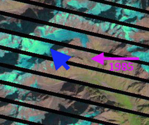
Above is a paired Landsat image from 1984 left and 2013 right indicating the 1100 m retreat during this period.
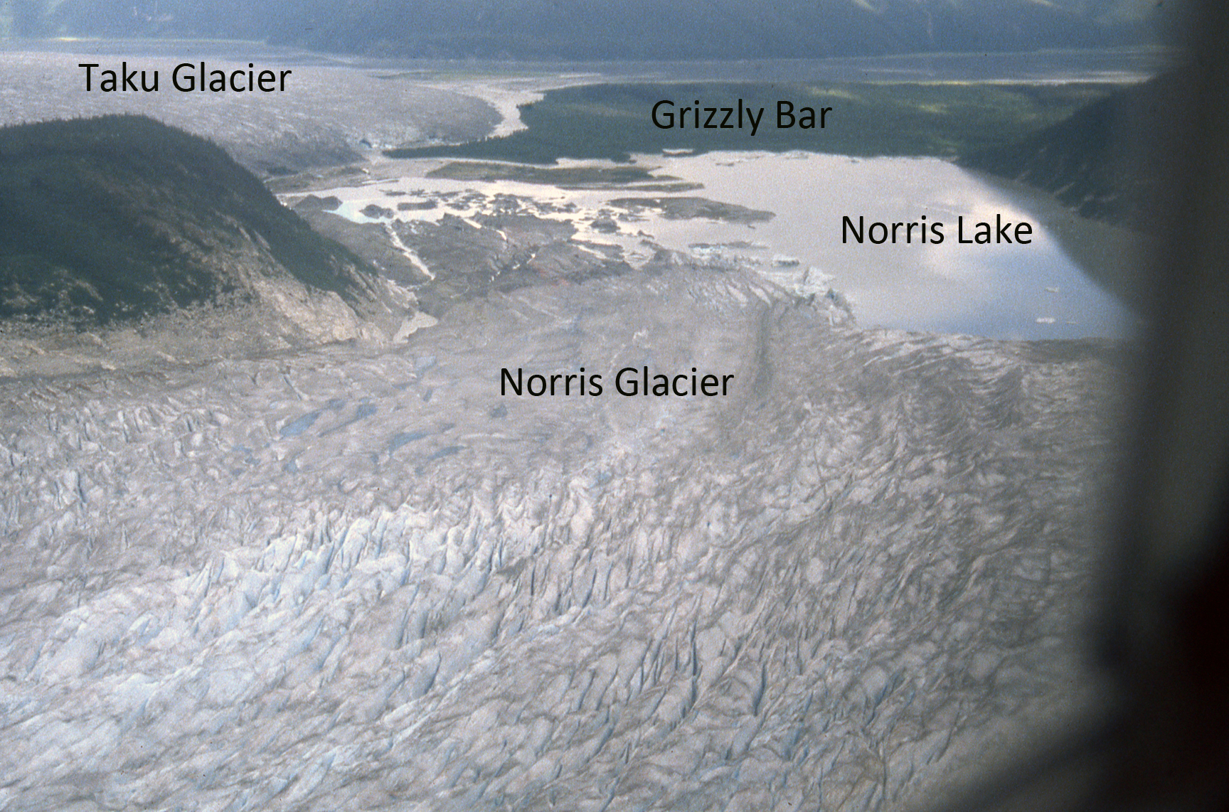
Norris Glacier began retreating before 1890 and has continuously retreated 2050 m from its 19th-20th maximum achieved around 1915. The glacier ended in a lake referred to here as Norris Lake from 1948 until 2007. By 2010 the glacier had retreated from this lake. Here we examine images from fieldwork conducted by the Juneau Icefield Research Program and overflights as part of the program from 1975 to 2010 and Google Earth imagery. I have had the chance to cross this glacier on ski a half dozen times as part of JIRP, and is was seldom an easy traverse, hence the names death valley and dead branch for portions of the glacier. Norris Glacier does not receive much attention as the program is focused on the Lemon Creek Glacier and the more famous and largerTaku Glacier, and does not garner much of our attention.

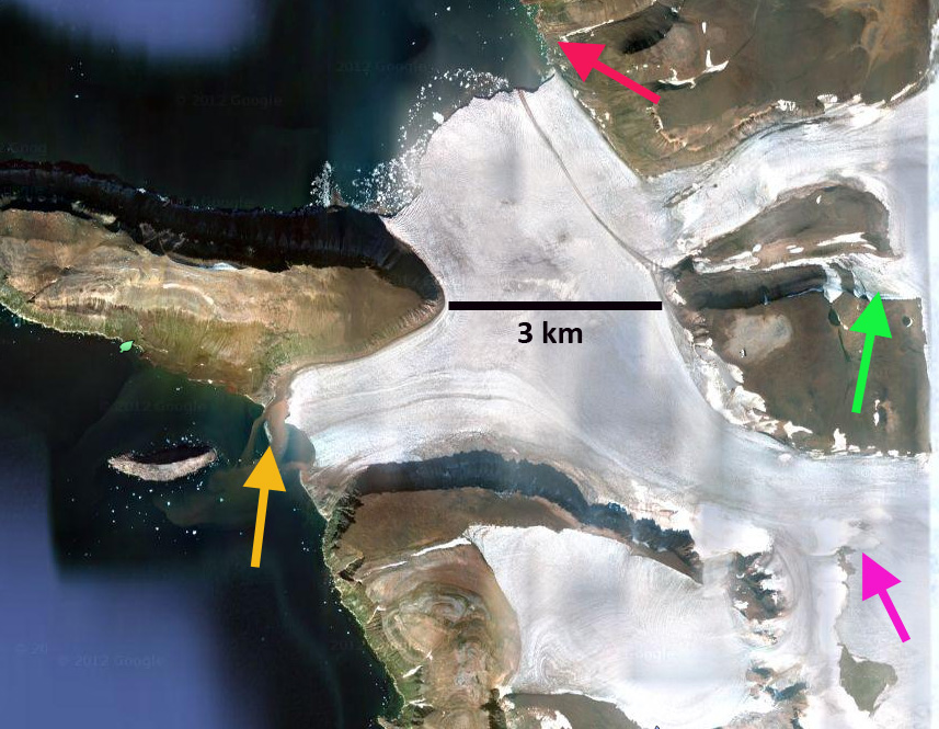
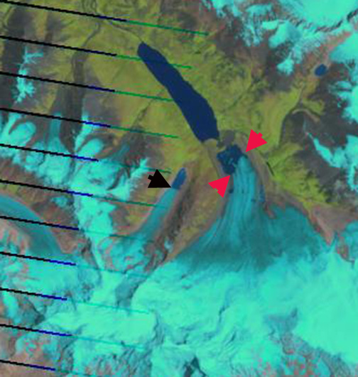
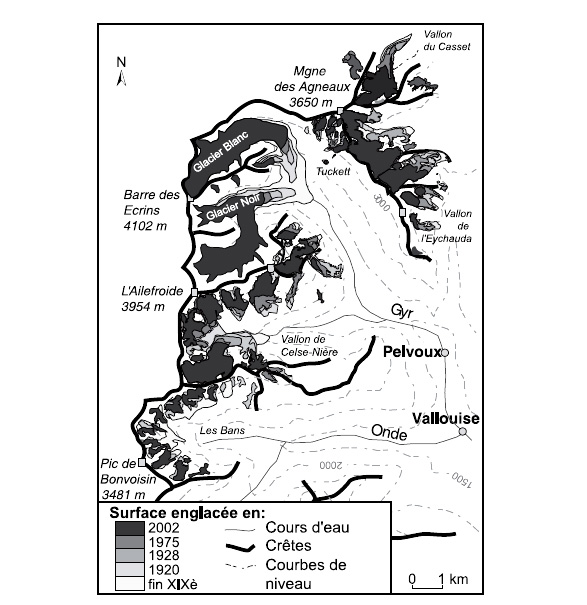
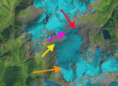
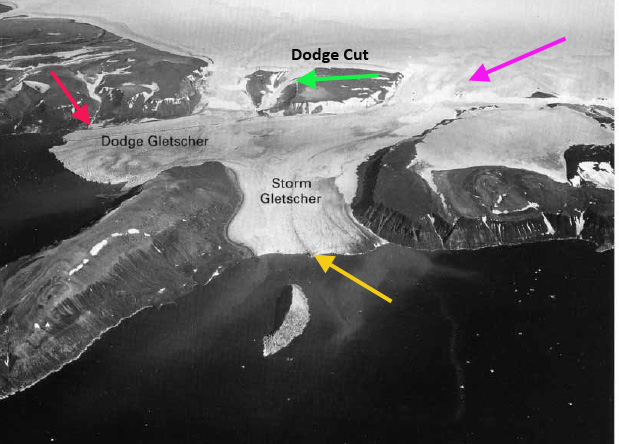
In 1948 the USGS map (top image) indicates Norris Lake was a narrow 200-500 meters wide lake and the glacier terminus was only 200 to 700 meters from Grizzly Bar, increasing with distance south along margin, an outwash plain built by the glacier beyond its advanced terminus position. By 1975 (second image; taken by Maynard Miller JIRP director for fifty years) the glacier had retreated an additional 250 meters, Norris Lake had expanded, but still had considerable ice along its western margin. The terminus was still extending a kilometer downvalley of the outlet of Glory Lake. The view of the entire glacier in Google Earth illustrates the direction of flow and accumulation sources blue arrows, typical snowline red dots and glacier boundary black line.
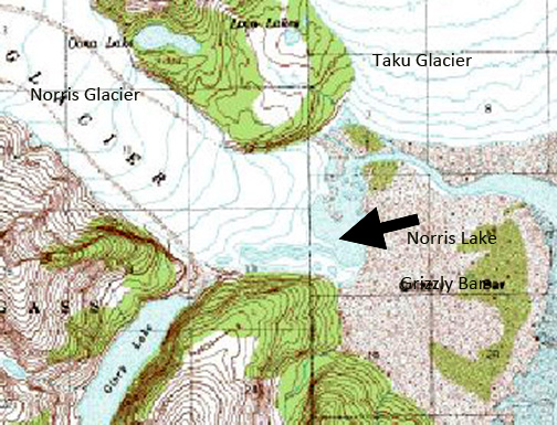
 norris_Glacier

norris glacier terminus 1975<norris full glacierIn 1998 I had the opportunity to fly over the glacier at the end of the field season. A series of images indicates the trimline that had developed with the recent glacier thinning of the last 50 years. Norris Lake had expanded to a length of 1.2 km on the north shore and 1.9 km on the south shore from Grizzly Bar. norris icefall

norris glacier terminus east 1998

norris terminus 1998 
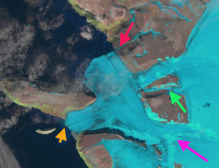
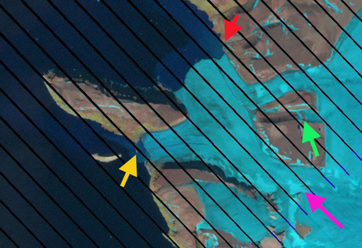
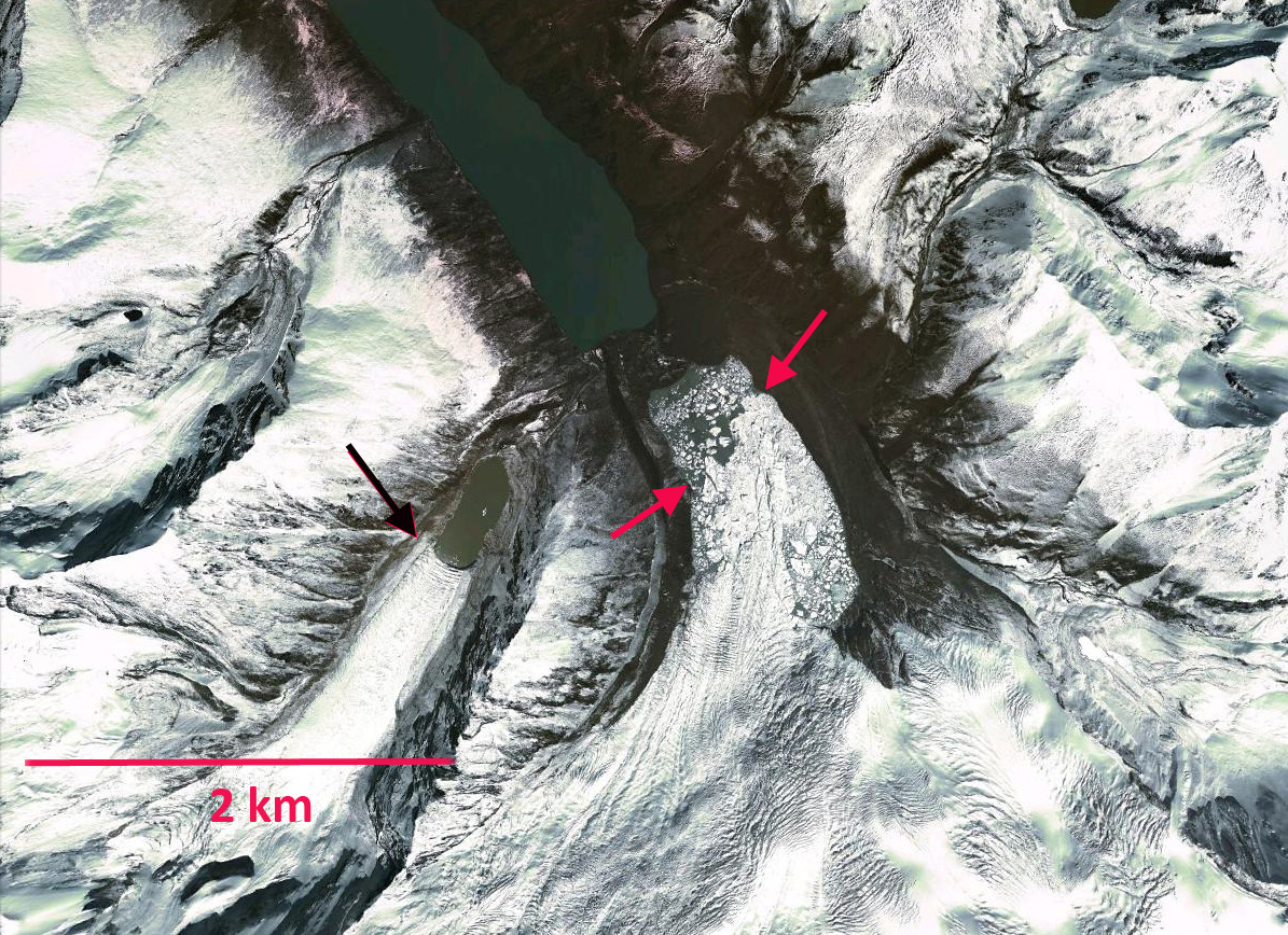
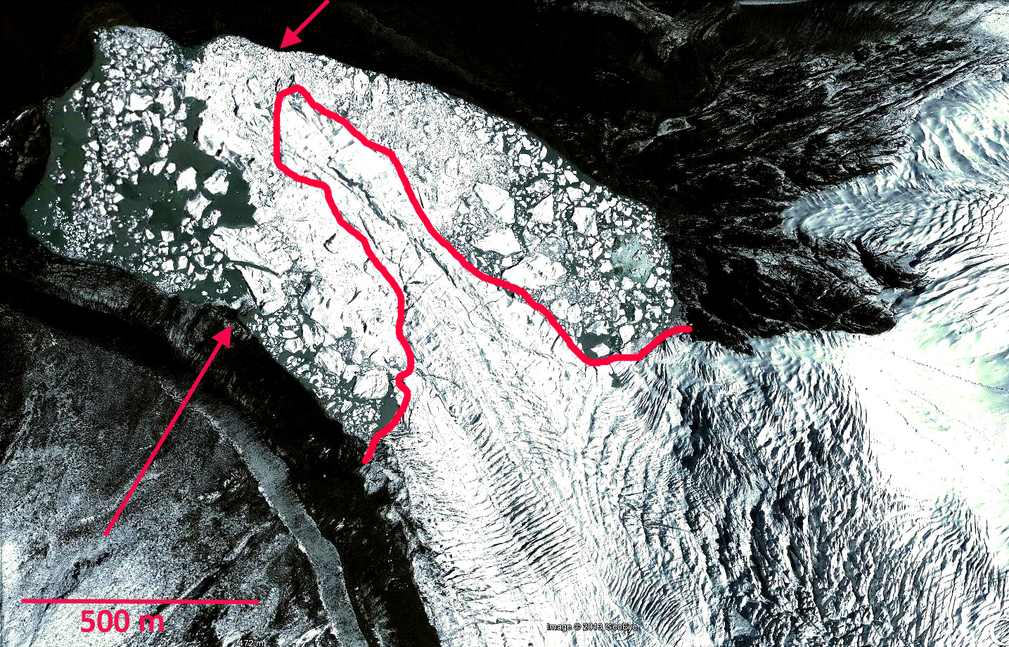
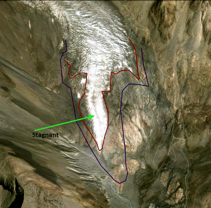
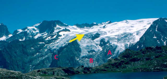
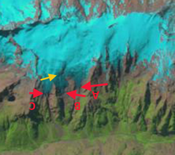
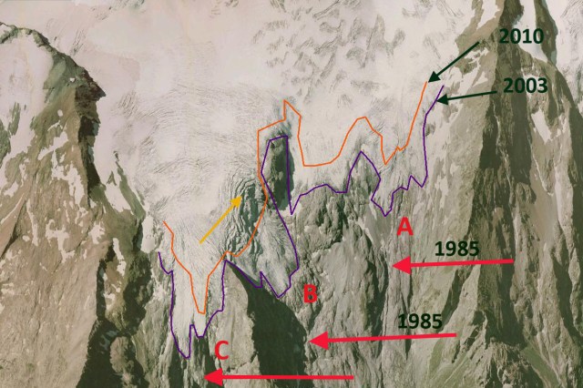
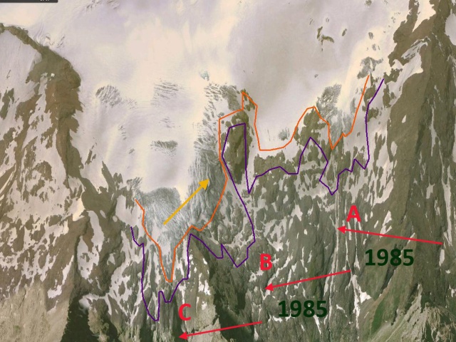
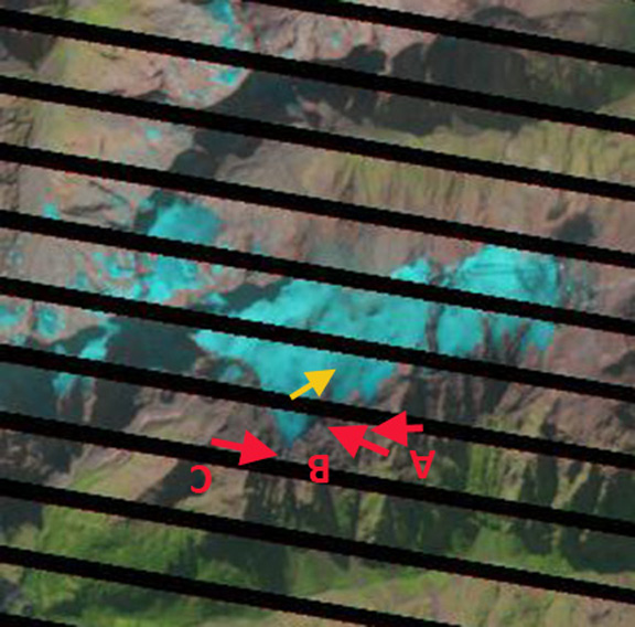
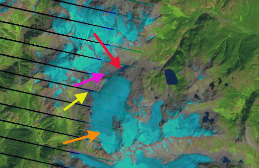
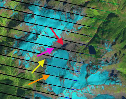
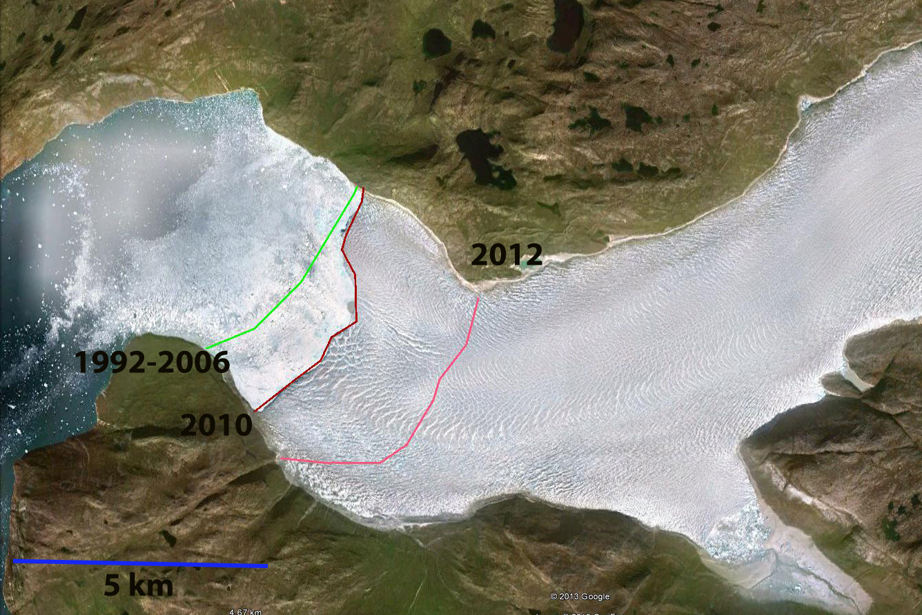
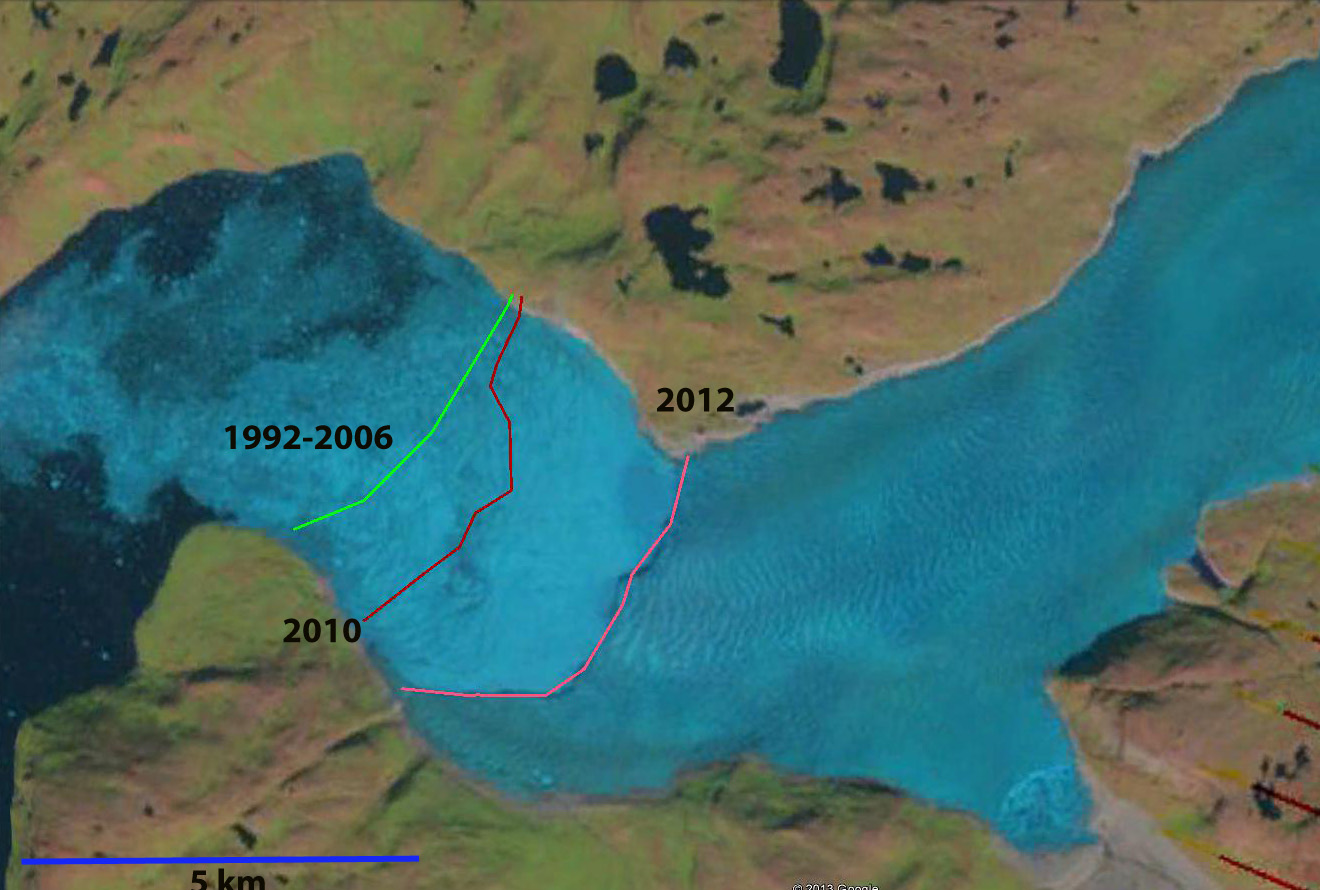
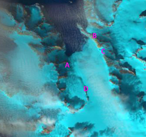
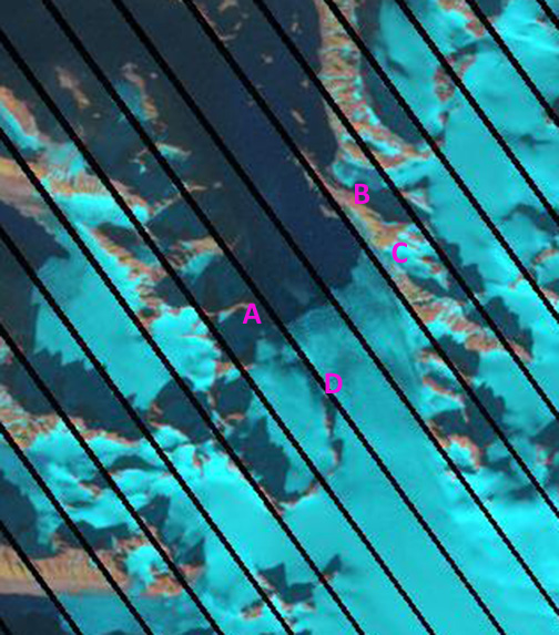
In 2010, images below, the glacier barely reached the edge of Norris Lake and the terminus was well up valley from the Glory Lake outlet, Grizzly Bar was 2.1 km from the terminus. By 2011 the glacier no longer reached the shore of Norris Lake. An examination of the icefall feeding the glacier terminus area indicates considerable melt out of crevasse features, indicating that flow is not that vigorous through the icefall above the terminus at 300 m, suggesting retreat will continue. The trimline hear has increased from 20 m to 50 m above the ice surface since 1975. norris aERIAL

norris glacier 2010 
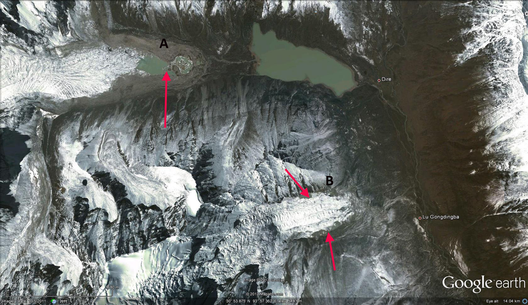
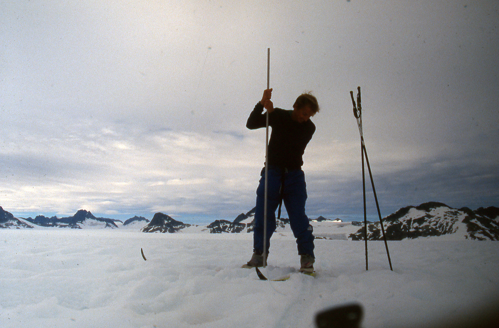
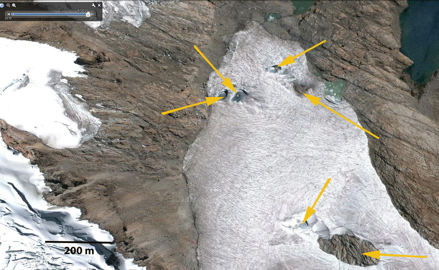
In the summer of 1998 we conducted extensive probing in the accumulation zone of the glacier, last two images in sequence below. This combined with annual identification of the snowline since 1994 indicates insufficient snowpack and continued thinning. This glacier has the majority of its area between 800 and 1200 m, with the average snowline since 1994 being 1000 m. Maximum accumulation is 1.5 m, whereas maximum ablation at the terminus exceeds 12 meters, hence you need a much larger accumulation zone to offset the higher terminus ablation. This glaciers retreat and lake expansion of the terminus follows the same pattern as all other glaciers of the Juneau Icefield except the Taku Glacier: Gilkey Glacier, Field Glacier, Eagle Glacier and Antler Glacier. norris accumulation

pelto probingsnowline

Lower Curtis Glacier Annual Survey 1984-2012

The Lower Curtis Glacier is an avalanche fed cirque glacier on Mount Shuksan in the North Cascades of Washington. It is a south facing and low elevation glacier for the range. This is an unusual combination that is supported by the heavy accumulation via avalanching from the upper slopes of Mount Shuksan. The glacier displays a magnificent set of annual layers in its terminus tongue. The terminus tongue is a spectacular wall of seracs that quickly rises 55 m above the bedrock. There are typically 50 layers visible indicating that this most of the ice in the glacier is 50 years of less in age. The glacier advanced from 1950-1985 and has retreated 155 meters from 1987-2009 in the glacier center and 135 meters on average across the front. A longitudinal profile up the middle of the glacier indicates that it thinned 30 meters from 1908-1984 and 15 m from 1984-2012. Because of its heavy accumulation via avalanching the glacier moves rapidly and is quite crevassed at the terminus. Each year we survey the terminus location, measure the mass balance and survey the glacier surface elevation on a cross profile. The video is from footage taken in 2011 and 2012. The annual terminus photographs are from near Lake Ann, the 2003-2012 sequence represents the digital camera era. This coming summer will be our 30 consecutive summer on the glacier and we will see if it is the seventh consecutive summer of wet weather when we are there.

Narssap Sermia Retreat, SW Greenland

Narssap Sermia is a calving tidewater glacier in southwest Greenland. This glacier had a stable terminus from 1970-2000. From 2006 to 2012 the glacier has begun a significant retreat. Rignot et al (2006)and Joughin et al (2010) noted that the glacier sped up dramatically in 2005 and 2006 at the time of the retreat initiation. This was an acceleration of at 150%, and the retreat from 2000-2010 was 500 m (Howat and Eddy, 2011). An examination of Landsat images from 1992 and 2012 and Google earth Imagery from 2006 and 2010 document the initiation of this retreat. In 1992 the glacier nearly reached the tip of the Peninsula, green line marking the terminus position. The burgundy arrows indicate proglacial lakes that are dammed by the glacier for a period each summer. In 2006 the glacier is still in the same location as in 1992. In the 2010 Google Earth image the glacier has begun its retreat from the green to the burgundy line, this is 1.3 km on the south side and 200 m on the north side. In 2012 the terminus has retreated to the pink line that is a retreat of 3.1 to 3.4 km. The terminus on the north is now at the point where the glacier turns due east-west. This is similar to the retreat of Kangiata Sermia just to the south and Kuusuup Sermia. In a future post we will examine the snowline variation on Narssap Sermia. Pictures below in order are from 1992, 2006, 2010, 2012 and 2012. akugdlerssup sermia 1992
1992 Landsat image
akugdlerssup sermia 2009
2009 Landsat Image

akugdlerssup sermia terminus 2010
2010 Google Earth image

akugdlerssup sermia 2012 terminus
2012 Landsat image

akugdlerssup 22142012
2012 Landsat image

Gold Rush Glacier Retreat, Alaska

The headwaters of Porcupine Creek in the Haines Borough of southeast Alaska is an unnamed glacier. Gold Rush Glacier is the name applied here, since there are many Porcupine Creek’s in Alaska but only one featured on the excellent Discovery Channel show Gold Rush. Gold Rush Glacier is comprised of an eastern and western glacier that in 1986 joined at the terminus. The glacier begins amid a series of peaks from 1500-1650 meters, and descends to 975 m. gold rush glacier map
Landsat imagery from 1986, 2004, 2010 and 2014 along with Geoeye imagery from 2011 and 2012 are utilized here. In 1986 the east and west termini of Gold Rush Glacier meet at 950 m, red arrow, melt water is released into Porcupine Creek, blue arrow. In the next valley south is The Tsirku River, flowing into it is the LeBlondeau Glacier, pink arrow. This glacier emerges from the mountains onto the valley bottom and the terminus spreads out. In 1986 there is no lake at its terminus, pink arrow. By 2004 the Gold Rush Glacier termini have separated and a lake has formed on the west side of the LeBlondeau Glacier terminus. The snowline was very high in 2003-2005 in southeast Alaska, and is marked by black dots in this image. The glacier needs to be more than 50% snow covered at summers end. This image is from late August with 3-4 weeks of melting and already only 30% of the glacier is snowcovered. In 2010 the Gold Rush termini are separated by 300 meters and the glacier has retreated from the trimline, yellow dots of the 1980’s. LeBlondeau Glacier has developed a lake across its entire front. The 2011 image indicates the glaciers as nearly all snowcovered in late September as the winter season begins. The melt season at 1000 meters in this region typically is over between September 10th and 20th. The lake at the end of LeBlondeau Glacier is now 1100 meters east to west and 500 meters across. In 2012 the termini of Gold Rush Glacier have retreated 350 meters from the 1986 position and are 400 meters from each other. In 2014 the terminus lake at LeBlondau Glacier has continued to expand from 2010 and the snowline on Aug. 2 with eight weeks left in the melt season is quite high on Gold Rush Glacier.

The key for Gold Rush Glacier survival is maintaining sufficient snowpack into August in its main accumulation basin 1250 meters. There has not been much accumulation retained here in 2013 or 2014. Having completed lots of snowpits (last image) in the summer on Southeast Alaskan glaciers the snow depth in early July needs to be more than 2.7 meters to survive the summer melt, last image from Chris McNeil. As of Jan 26 2012 the National Operational Hydrologic Remote Sensing Center is indicating five feet of snow on the Gold Rush Glaciers with 0.4 m of snow water equivalent, this is close to average. Two valleys and kilometers east is Little Jarvis Glacier. This glacier was surveyed in 1957 and 1995 and found to have retreated a modest 190 m and thinned very little except right at the terminus (Sapiano et al, 1998). Gold Rush Glacier experienced a minor retreat of less than 100 meters from 1957-1986. This indicates that the Haines Borough glaciers saw modest changes until the 1990’s. Gold Rush Glacier has been retreating in a less spectacular fashion to the nearby larger Brady Glacier and Riggs Glacier but similar to the comparably sized Lemon Creek Glacier.

gold rush glacier 1986
1986 Landsat image

Gold rush glacier 2004
2004 Landsat image

gold rush  glacier  2010
2010 Landsat image
gold rush 2014
2014 Landsat image

goldrush 2011
2011 Geoeye image
gold rush 2012
2012 Geoeye image

Slide3

Svitjodbreen Retreat, Northwest Svalbard

Svitjodbreen is a 10 km long tidewater outlet glacier in northwest Svalbard, Albert Land. The glacier drains north into Fugelfjorden, the highest elevation of the main glacier is 600 meters with a few neighboring peaks reaching 800 m, not very high. NW Svalbard is a region that has experienced extensive long term thinning from 1965 to 2007 (Nuth et al, 2010), with an average glacier wide thinning of 0.5 m/year and frontal thinning of over 1 m/year. nw svalbardjarlbreen overview copyThe retreat is similar to that of Southern Svalbard at Hornbreen and Hambergbreen and much faster than in Eastern Svalbard at Edgoya. Here we examine Landsat images from 1987, 2000 and 2011 and a Google Earth image from 2009. In each image there are four fixed points: Point A is on the south side of the ridge just south of Rissabreen. Point B is at a small peak, Hirdfjellet. Point C is at the beginning of the Skutelen Peninsula just south of Hirdfjellet and Point D is a small bedrock ridge. In 1987 the terminus extends across the 2 km wide fjord one kilometer north of the ridge on the west side of the glacier labelled A and extends directly across the fjord to Point B. Point D is 3 km behind the glacier front and Point C is 1.5 km from the ice front. By 2000 the western side of the terminus has retreated nearly 500 meters and the east side by Point B very little. In 2011 the terminus has retreated beyond the bedrock ridge at Point A and extends across the fjord to Point C. The bedrock Point D is now just 1.6 km from the glacier front. Jarlbreen has retreated 1200 to 1500 meters from 1987 to 2011, with most of the retreat occurring after 2000.

jarlbreen 1987

jarlbreen 2000
jarlbreen 2012
The front of the glacier is heavily crevassed indicating considerable calving activity. Google Earth refers to this glacier as Jarlbreen, but Jarlbreen is east of the Skutulen Peninsula. The ridge at Point D has expanded as the glacier has thinned. Oerlemans et al (2011) noted a similar retreat rate for Hansbreen. They further determined that calving losses were of the same magnitude as melting losses. jarlbreen ge

Corihuasi East Glacier Retreat, Peru

In the Cordillera Centrale of Peru a series of glaciers extends north from Pariacaca. Pariacaca is the pre-Incan god of water, appropriate name in this dry region, that is draped with glaciers and has numerous alpine lakes. On the north side of Pariacaca Mountain is the Corihuasi East Glacier. The Corihuasi Glacier has been retreating and has developed a number of holes that penetrate the glacier to its bedrock base. The retreat of this glacier is similar to that of Manon Glacier and Chuecon Glacier in this same mountain range. The glacier flows northeast beginning at 5200 meters and ending at 5100 meters. The glacier is 1.3 km long and has an area of 0.8 square kilometers in 2010. corihuasi e This post examines Landsat imagery from 1998, 2005, 2011 and 2012 and Google Earth imagery from 2010, shown in that order below. The red arrow in each image indicates the 1998 terminus location which ended in a lake. The yellow arrow indicates the location of a bedrock exposure amidst the glacier that will develop and enlarge. By 2005 the glacier has retreated from the lake, 110 meters from 1998 and the bedrock exposure is evident. In 2011 and 2012 the glacier has retreated 200 meters from the 1998 position and the bedrock exposure has greatly expanded. The Google Earth imagery has much better resolution. The size of the bedrock exposure is 230 meters by 100 meters. What is of greater concern for the survival of this glacier is the development of a number of holes in the glacier that reach the glacier base, at the yellow arrows. There is a clear depression extending west from the main bedrock exposure to another depression reaching the glacier bed, this will allow expansion of the main bedrock exposure from 230 m to 400 m. In each case once bedrock at a glacier base is exposed this will speed up melting of the surrounding ice and demise of this glacier. This glacier will not survive current climate because in many years such as 1998 and 2010 the glacier has lost all its snowcover indicating a glacier that does not have a persistent accumulation zone. Without a persistent accumulation a glacier cannot survive. (Pelto, 2010). corihuasi e 1998

corihuasi e 2005

corihuasi e 2011

corihuasi e 2012

corihuasi e close

Riggs Glacier Retreat from the Sea, Alaska

Riggs Glacier for most of the 20th century was a tributary to the Muir Glacier in Glacier Bay Alaska. The two glaciers separated between 1960 and 1963 as noted by the USGS in their detailed research led by Bruce Molnia . The USGS chronicled the changes of this glacier from 1940 to 2004 with pictures from the same location by Bruce Molnia. The Muir and Riggs are still joined in 1950 and the Riggs Glacier is retreating out of sight into its own valley by 2004. 1950_muir_glacier

2004_muir_glacier
Dan Lawson in a 2004 National Park Service brochure noted that Riggs Glacier was about 1.2 km wide at the terminus, had a 40 to 90 feet high ice face and was 15 miles long. The terminus that had been calving into Muir Inlet for the entire 20th century became mostly terrestrial during the mid-1980,s as an outwash delta built at the southern margin. In 2004 tidewater only reached the terminus during higher tides on either side of the bedrock knob that separates the glacier into two ice tongues. Riggs Glacier has been thinning progressively over the past two decades and is expected to continue thinning and slowly receding. Ice recession has been averaging about 20 to 30 feet per year for the last 5 years. This post examines changes as seen in Landsat images from 1990 to 2011.

In 1990 the two terminus tongues are still connected at the black arrow, and a prominent knob is just being exposed by retreat of the western terminus, red arrow. The terminus still reaches tidewater on the very northern margin. There is no vegetation evident on the knob separating the ice tongues. A tributary from the east at the orange arrow just reaches the Riggs Glacier. By 1999 the termini are separated the prominent knob is now fully exposed by retreat of the western terminus and the glacier is no longer tidewater except briefly at high tide. Vegetation has become to develop on the rock knob that separates the two ice tongues. By 2009 the glacier has retreated well back from tidewater. The delta building in front of the eastern terminus has expanded into the inlet some. Vegetation has spread over most of the rock knob that separates the two ice tongues. In 2010 in a late summer images the snowline of the glacier is at 975 m. The tributary from the east at the orange arrow has retreated 1 km from the Riggs Glacier. By 2011 the western terminus has retreated 600 meters since 1990 and the eastern terminus has retreated 800 meters from the black arrow where it used to connect to the main glacier. Examination of the snowline elevation on Riggs Glacier indicates that it now typically it is typically between 950 and 1050 m. This recent increase in the snowline is similar to the increase seen on Brady Glacier. This has led to the glacier retreat and it no longer reaching the sea. riggs glacier 1990

riggs glacier 1999

riggs glacier 2009

Riggs glacier 2010
riggs glacier 2011

Dodge Glacier and Storm Glacier Retreat, Northern Greenland

The Dodge and Storm Glacier are two glaciers that separate 1.5 km from the ice front around Kap Alexander (Cape Alexander) in northern Greenland. The glaciers are fed not by the main Greenland Ice Sheet, but a local ice cap. Lauge Koch (1928) documented this in his map from the expedition to the region in 1920-1923. The black arrows in the map from his expedition indicate the highest point of the ice cap and the saddle separating the Greenland Ice Sheet from the Inglefield Land Ice Cap. dodge and storm glacier mapLauge Koch noted that the Dodge Glacier ended in an ice cliff, but did not seem to be calving any icebergs, though it probably did occasionally. He noted that Storm Glacier was a relatively crevasse free route onto the higher ice. In 1950 an aerial image from the USGS Satellite image At;as of Greenland, taken by the Danish glaciologist Anker Weidick, of the Dodge and Storm Glacier indicate the terminus of Dodge Glacier ending on northwest side of a valley entering from the valley from the north, red arrow. There is a small glacier flowing down the valley through a nunatak separating the Dodge and Storm Glacier, Dodge Cut, green arrow. The Storm Glacier ends at a small island, orange arrow. The pink arrow indicates an area where the ice slope increases, and bedrock knobs will later emerge. In the second image a Landsat from 1994 the Storm Glacier terminus appears to be at the same location as 1950. The Dodge Glacier has retreated approximately 200 meters from 1950 to 1994. There is still ice in the Dodge Cut, green arrow. There is one new rock outcrop that has emerged south of the pink arrow on the Storm Glacier. In the third image a Landsat from 2012 Storm Glacier has retreated from the island, 350 meters since 1994. Another rock outcrop has emerged from beneath the ice above the Storm Glacier terminus, pink arrow. There is no longer ice flowing through the the Dodge nunatak above Dodge Glacier, green arrow. The Dodge Glacier terminus has retreated 400 meters since 1994. This is a significant increase in retreat rate. Of more importance is that the glacier is now actively calving which was not the case during the Koch expedition or in 1950. The last image in the sequence is a Google Earth view from 2010. dodge and storm glacier 1950</astrom and dodge 1994storm and dodge galcier 2012

dodge storm glacier 2010
A closeup view of the Dodge Glacier terminus indicates the heavy crevassing near the calving front, indicating that calving will continue, this should lead to more retreat as well. A close up of Storm Glacier indicates the retreat from the small island, which is really a moraine emplaced by the glacier, and noted the brown color of the water entering the bay at the end of the glacier indicating runoff and erosion occurring from beneath Storm Glacier. Dodge and Storm Glacier are retreating like the glaciers to the north and south draining the main ice sheet, Humboldt Glacier and Kong Oscar Glacier.dodge glacier front

storm glacier front

Sepu Kangri Glacier Retreat, Tibet, China

There are two glaciers that drain the north side of Sepu Kangri Peak in the Eastern Nyainqêntanglha Mountains of Tibet in China. Most of the peaks in East Nyainqêntanglha Mountains are unclimbed, Sepu Kangri the highest peak was not climbed until 2002. The Sepu Kangri Glaciers drain into thw Salween River. sepu kangri profile
In a recent study by Tobias Bolch et al (2010) in the western Nyainqêntanglha Mountains glacier area decreased by −6% between 1976 and 2001 and continued to shrink during the period 2001–2009. Li et al (2010) examined glacier change over the last several decades in China and found ubiquitous glacier retreat and commonly lake formation as glaciers retreated. In this case we compare Landsat images from 1988, 2003 and 2010 and Google Earth images from 2011. In 1988 the lakes at the end of the two glaciers are indicated by pink arrows form the main terminus the eastern glacier, and black arrow for the smaller western glacier. By 2003 there is limited terminus change for the main terminus. The western terminus has retreated 200 meters. By 2010 the terminus tongue is breaking up for the eastern glacier terminus. By 2011 the lake has expanded from a length of 600 meters in 1998 and 1300 meters in 2011. The western terminus has retreated another 100 meters. A closeup view in Google Earth of the eastern tongue indicates that this lake will quickly develop to an area of 1.7 km long and 0.8 km wide. Notice all of the icebergs in the lake. This glacier remains heavily crevassed and has a vigorous accumulation zone indicating that it is not in danger of disappearing with current climate.sepu kangri 1988

sepu kangri 2003

sepu kangri 2010

sepu kangri ge

sepu kangri tongue
The formation of lakes at the end of the glaciers is quite common. If we look 10 km east of Supa Kangri are two more developing lakes that we will focus upon later. All of the lakes are in the 4700 and 4800 meter elevation range. The lakes are also common features of retreat in the main Himalayan range for retreating Tibetan glaciers, Reqiang Glacierand Menlung Glacier
sepu kangri east

Glacier Blanc on Ecrins Retreat, France

Glacier Blanc is on the east side of Barre Des Ecrins the southernmost of the 4000 m peaks in the Alps. It is the largest glacier on the peak. The glacier began a sustained retreat after 1870, that ceased in 1895-1900 , 1915-1920, 1935-1940 and 1980-1990 (Cossart et al, 2006). The glacier had a mass loss of 11 m from 1981-2005 (Rabatel et al, 2008), which is 5-10% of the total glacier volume. variations John Hessler, a physical geographer has an excellent series of images from Glacier Blanc, including the image above of terminus change from the Cossart et al (2006) paper. Glacier Blanc was joined with Glacier Noir in 1900, today Glacier Blanc has retreated 1.5 km from the former connection in the St. Pierre River valley, as seen in the image below from Cossart et al (2006). blanc map
The series of images below are used to examine the retreat over the last 27 of Glacier Blanc. The first image is a 2003 Google Earth image illustrating the 1985 terminus a pink line, 2003 a purple line and 2010 a red line. The images following are a 1985 Landsat image, pink arrow terminus and blue arrow snowline. The closeup of the terminus in 2003 and 2010 indicates the change in terminus position and stagnant ice. The last image from 2012 notes the 1985 terminus position with pink arrow and the snowline blue arrow. Retreat from 1985 to 2003 was 320 meters, 18 meters/year. From 2003 to 2010 retreat is 250 meters, 36 meters/year. The rate of retreat is increasing. This glacier largest area is the valley basin from 3000 to 3300 meters which is 2.7 km long and 0.9 km long. For the glacier to babove 3200 meters from 2002-2005 (Rabatel et al, 2008). This basin certainly is over deepened and would have a lake if the terminus retreats into it significantly. The glaciers retreat has been similar to that of Glacier de la Girose just 15 km north. glacier blanc ecrins

glacier blanc 1985glacier blanc terminus 2003

glacier blanc terminus 2010

glacier blance 2012

Glacier de la Girose Retreat, France

Glacier de la Grirose (Girose) is one of the most travelled glaciers in the Alps. It is part of the Les 2 Alpes ski resort, used primarily for summer skiing. The main glacier serviced by a lift is Glacier Mantel just to the west of Girose. 2alpes_plan-de-pistes Despite the frequent visits to the glacier by skiers it has not been the focus of much study. The glacier is smaller than often visited but seldom skied Mer De Glace, similar to Glacier Blanc 15 km south and larger than the Grande Motte at Tignes ski area. Here we examine changes from 1984-2012 using Landsat images, Google Earth images and two photographs. Girose has three termini from west to east labelled A-C. The 1985 terminus location is marked by red arrows, the 2003 terminus is indicated by a purple line, the 2009 terminus by an orange line adn the lip of a key icefall here the middle branch (B) separates from the main branch (C). In 1985 this icefall lip is 500 m above the terminus. The two western termini A and B both extend well below the main icefield of Girose in 1985, by 2012 the tongues barely extend beyond the main glacier. The views of the terminus are in order a 1984 photograph, a 1985 Landsat, 2003 Google Earth, 2010 Google Earth and 2012 Landsat image. They are all viewed from the north. Retreat from 1985 to 2010 has been 420 m at terminus a, 500 m at terminus B and 350 m at terminus C. The overall rate is 15 meters/ year. girose glacier 1984

girose glacier 1985

glacier girose terminus 2003

girose glacier terminus 2010

girose glacier 2012

Of greater concern is the expansion of outcrops amidst the accumulation zone of the glacier from 2003 to 2010. This indicates thinning in the accumulation zone, which indicates the lack of a persistent snowcover even for many regions high on the glacier. The two images below identify three locations, at A and B the expansion of bedrock is evident. The scale is the same, at point A the rock outcrop is no longer a narrow linear feature. At Point B the rock outcrop is much longer. At point C there is a sharp reduction in crevassing, and the glacier surface is quite dark colored, this is not a rock amidst the glacier, instead the dark area indicates a portion of the glacier surface that has persistently lost its snowcover and where dirt at the surface has been preferentially enriched. This helps speed thinning, but in the former accumulation zone is a sign it is no longer an accumulation zone. The ski season is supposed to extend from mid- June to Sept. 1 for Les 2 Alpes on the glaciers, in many recent years the season is cut short on Girose. girose glacier acc zone 2003

girose glacier acc zone 2010

Snowcap Creek Glacier Retreat, British Columbia

Snowcap Creek Glacier is one valley north of Stave Glacier in the Garibaldi Provincial Park Region of British Columbia. The retreat of glaciers in this region has been well documented by Koch et al (2009). The response varies from a glacier like the Helm Glacier which is melting away to the Snowcap Creek Glacier which is has been rapidly retreating but has remained vigorous.
snowcap creek 2006 ge
Landsat images and Google Earth images are used to document the development of a lake at the terminus of the glacier. In 1992 there is no lake at the main terminus, red arrow or subsidiary terminus at the yellow arrow. There is also a connection between the terminus and the glacier to the north at the magenta arrow. By 2009 there is a new lake at the main terminus that is 700 meters across the glacier reaches the western shore of this lake. A smaller lake has formed at subsidiary terminus, yellow arrow. The terminus is no longer connected to the glacier to the north at the magenta arrow. By 2012 the glacier has retreated 800 meters from 1992 and no longer reaches the western margin of the new unnamed lake, red arrow. The subsidiary terminus lake has expanded but is still less than 100 meters across.

snowcap creek glacier 1992
snowcap glacier 2009
snowcap creek glacier 2012

In each image the snowline is noted by a yellow-orange arrow, the glacier continues to have a persistent accumulation, which indicates it can survive current climate. A closer examination of the terminus in 2006 from Google Earth indicates the two new lakes, the detached ice remnant and active crevassing of the glacier surface close to the terminus. In 2006 the glacier terminus still reaches the newly formed lake. The active crevassing begins within 300 meters of the current terminus. The ice tongue reaching down to the lake has already retreated from it and this narrow tongue will be lost soon.
snowcap creek glacier terminus