Record High Mont Blanc, France Glacier August Snow Lines 2017

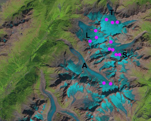
Landsat image of the transient snow line on Mont Blanc Glaciers, France on 8/19/2017.  The average snow line (Purple dots) is at 3100 m.  Glaciers on Mer de Glace (M), Argentiere (A), Tour Glacier (L), Trient Glacier (T) and Saleina Glacier (S). 

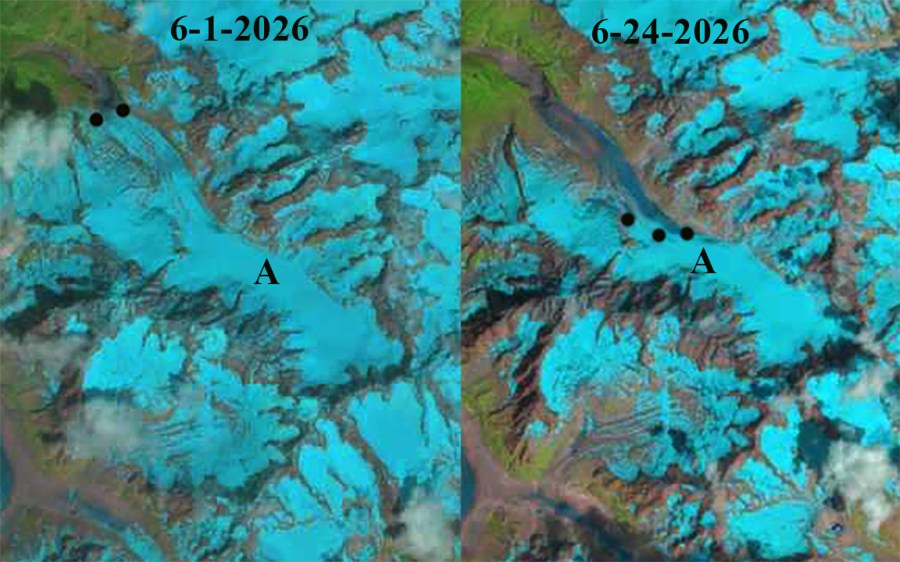
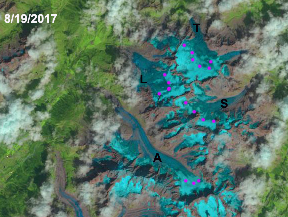
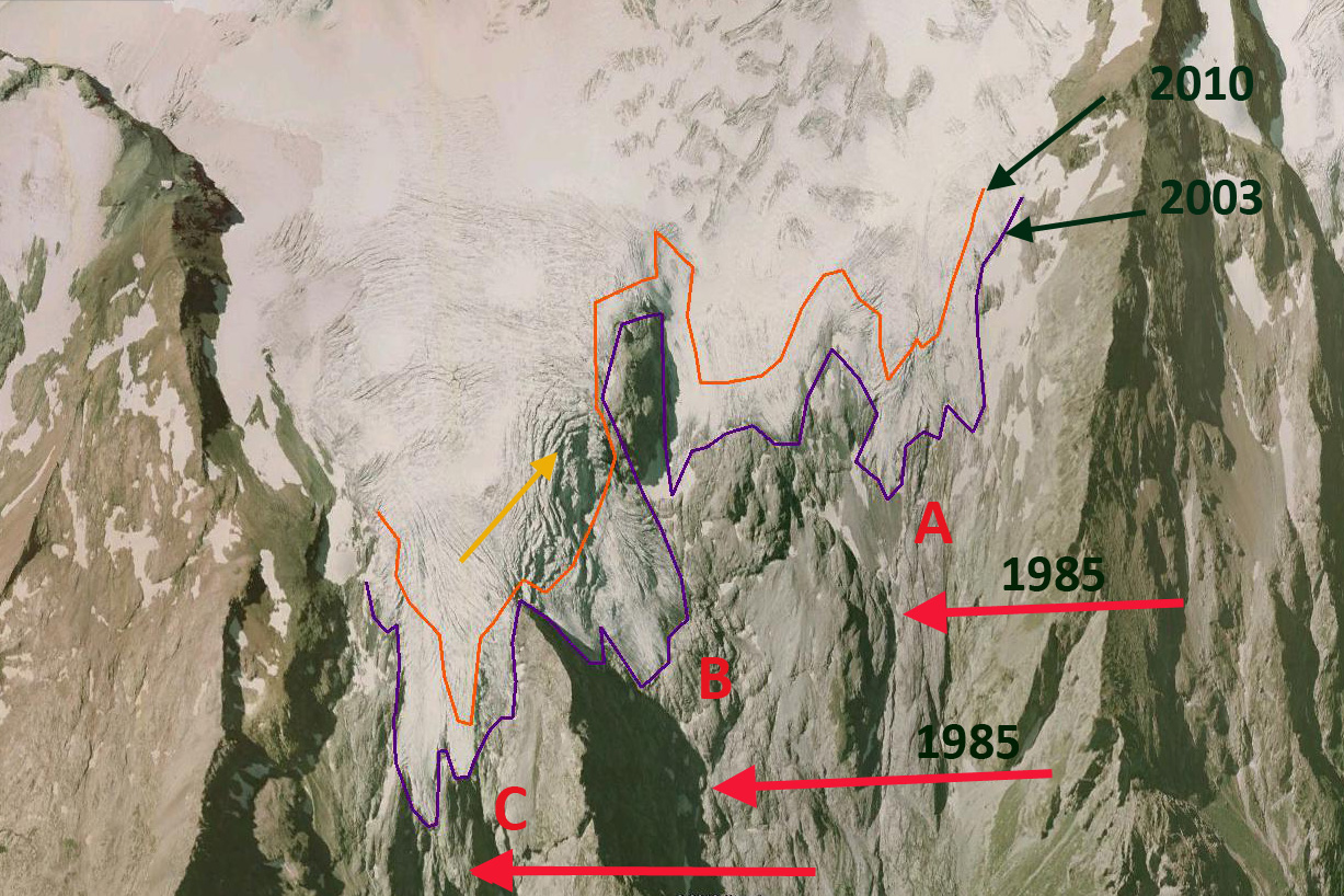
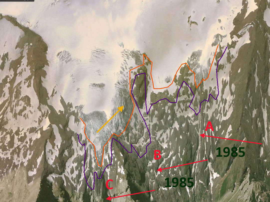
This has been a warmer summer in the Alps with reports emerging of various summer ski areas that take advantage of glaciers closing early or adding snow guns to stay open, Molltal Glacier, Les2Alpes,, Stelvio Glacier  Here we compare in Landsat images the transient snow line on five Mont Blanc glaciers from 1985, 1988, 2003, 2014, 2015 and 2017.  The transient snow line is indicated with purple dots in each image.  A comparison of the transient snow line on Mont Blanc glaciers on 8/19/2017 to other years indicates it is already higher than all other years examined, but a month remains in the melt season. 

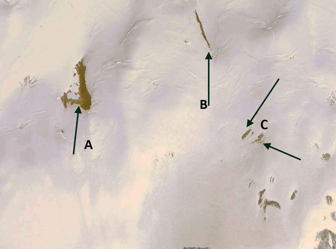
Rabatel et al (2013)  examined the equilibrium line altitude (ELA) of glaciers in the region from 1984-2010.  The ELA is the snowline at the end of the summer melt season.  The transient snow line is simply the snow line altitude on a specific day during the melt season. Rabatel et al (2013) found the average snow line of 3000 m on Trient Glacier, 2900 m on Tour Glacier, 2800 m on Argentiere Glacier and 2975 m on Saleina Glacier.  They also observed the maximum snowline occurred in the western Alps in 2003 with an average of ~3250 m, this average is higher than for just the Mont Blanc glaciers. 

On August 11, 1985 the snow line averages 2800 m on the five glaciers.  In 1988 on Sept. 12 the snowline averages 2900 m.  On August 5, 2003 the average snow line is at 3025 m.  On Sept. 12 2014 the average snow line is at 2850 m.  On Aug. 31, 2015 the average snow line is at 3050 m.  On Aug. 19th 2017 the average snow line is at 3100 m.  This is the highest observed August snow line on Mont Blanc. With several weeks to go the snow line is competition with 2003 for the highest snow lines on Mont Blanc glaciers in the last 50 years by the end of the melt season. 

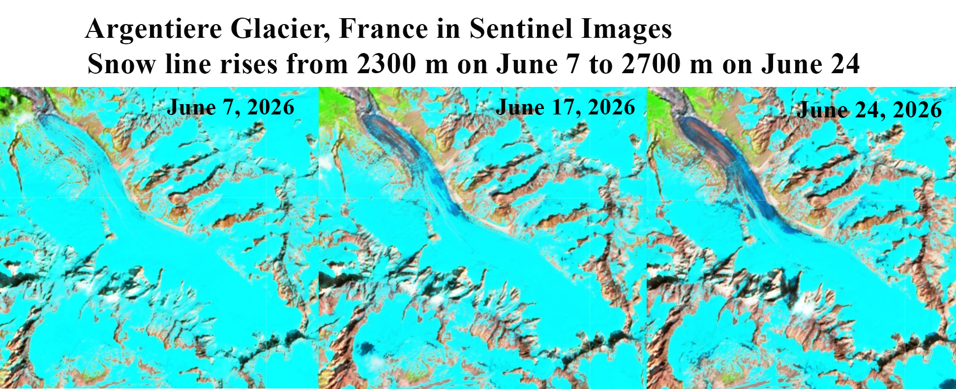
Six and Vincent (2014) noted for Argentiere Glacier that for each 1 C rise in temperature the ELA rises 50 m.  The higher snow line in 2017 indicates a year of significant negative mass balance, which will further enhance retreat of the the Mont Blanc glaciers, such as Mer de Glace and Tour Glacier. 

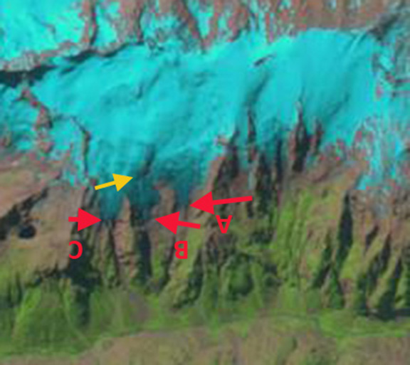
Landsat image of the transient snow line on Mont Blanc Glaciers, France on 8/5/2003.  The average snow line (Purple dots) is at 3000 m.  Glaciers on Mer de Glace (M), Argentiere (A), Tour Glacier (L), Trient Glacier (T) and Saleina Glacier (S).

Landsat image of the transient snow line on Mont Blanc Glaciers, France on 8/11/1985.  The average snow line (Purple dots) is at 2800 m.  Glaciers on Mer de Glace (M), Argentiere (A), Tour Glacier (L), Trient Glacier (T) and Saleina Glacier (S).


Landsat image of the transient snow line on Mont Blanc Glaciers, France on 9/12/1988.  The average snow line (Purple dots) is at 2900 m.  Glaciers on Mer de Glace (M), Argentiere (A), Tour Glacier (L), Trient Glacier (T) and Saleina Glacier (S). 

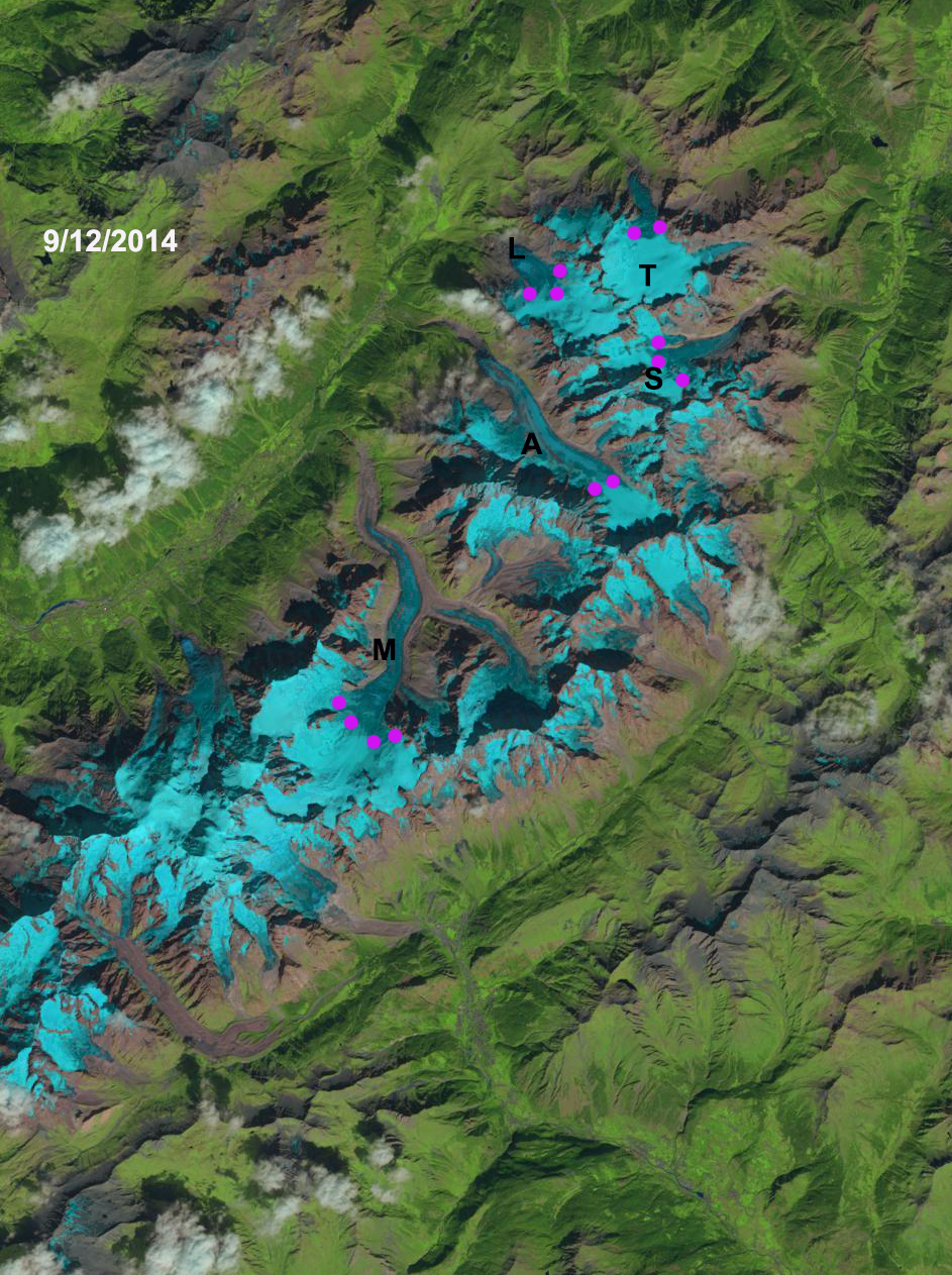
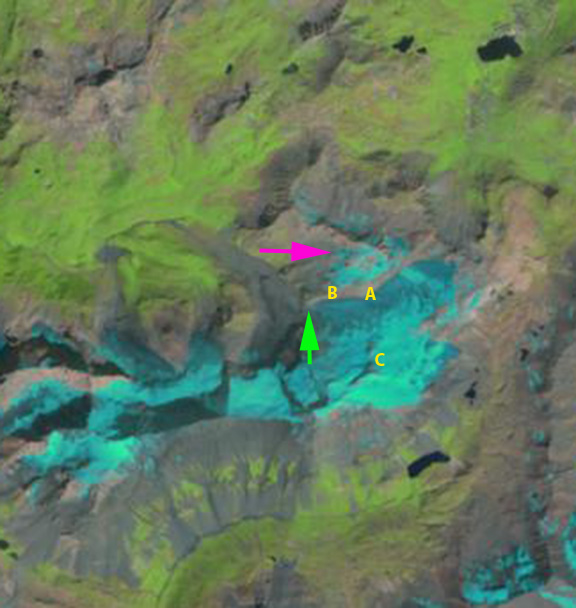
Landsat image of the transient snow line on Mont Blanc Glaciers, France on 9/12/2014.  The average snow line (Purple dots) is at 2850 m.  Glaciers on Mer de Glace (M), Argentiere (A), Tour Glacier (L), Trient Glacier (T) and Saleina Glacier (S). 

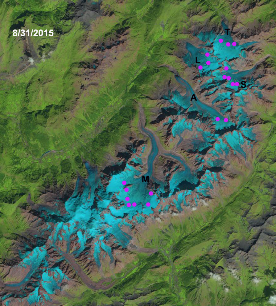
Landsat image of the transient snow line on Mont Blanc Glaciers, France on 8/31/2015.  The average snow line (Purple dots) is at 3050 m.  Glaciers on Mer de Glace (M), Argentiere (A), Tour Glacier (L), Trient Glacier (T) and Saleina Glacier (S). 

Bionnassay Glacier Terminus Tongue Detaches, Mont Blanc, France

Bionnassay Glacier drains west from Dôme du Goûter and Aiguille de Bionnassay of the Mont Blanc Massif in France. The glacier has a heavily debris covered terminus and has experienced less retreat from 1980-2010 then other Mont Blance glaciers. Bionnassay retreated 200 m (Moreau et al , 2012), while Mer de Glace retreated 500 m in the interval 1998 to 2008. Gardent et al (2014) observed a 25% decline in the area of glaciers in the French Alps from 1970 to 2009, with the rate increasing significantly recently.  Bionnassay is now in rapid retreat as the stagnant terminus tongue is detached from the active glacier tongue.

bionnassay overview

Bionnassay Glacier.  Red arrow indicates terminus of stagnant region.  Yellow arrow indicates bedrock emerging that is separating stagnant terminus tongue.  Green arrow indicates lower limit of active glacier. 

In 1985 the glacier terminus is at the yellow arrow. The debris covered ice is crevassed and covers the entire region at the red and green arrow. Points B and C are ice covered and Point A has a small exposure of bedrock. In 1999 retreat from the yellow arrow is evident the glacier still covering the region at the red and green arrow. In 2001 Google Earth image the terminus is evident at the red arrow, the region at the green and yellow area are covered by glacier ice. In 2011 the terminus has retreated 180 m since 2001, bedrock has emerged at the green arrow, beginning to separate the stagnant debris covered terminus tongue. At the yellow arrow the crevassing has diminished greatly. In 2015 the terminus has retreated to the pink arrow. Bedrock has been exposed from below the glacier terminus tongue at the yellow arrow. The active glacier terminus is now at the green arrow. At Point B and C glacier thinning has led to marginal retreat and exposure of bedrock where there was glacier ice. At Point A the expanse of exposed bedrock has greatly expanded.  The retreat of the main glacier terminus is around 200 m.  However, the retreat to the newly emergent bedrock separating the glacier is 750 m.  The active terminus is now 1700 m from the 1985 terminus position at the green arrow.  In the next few years this will become a well defined terminus, as the lower stagnant zone melt away.

Bionnassay Glacier is just south of Taconnaz Glacier, which is also retreating.
bionnassay 1985
1985 Landsat image
bionnassay 1999
1999 Landsat image
bionnassay glacier ge 2001
2001 Google Earth Image
bionnassay glacier ge 2011
2011 Google Earth Image
bionnassay 2015
2015 Landsat image

500 m

Disintegration of Pramecou Glacier, France

Pramecou Glacier is on the Dome de Pramecou above the Grande Motte Glacier, which is a key portion of the Tignes Ski area in France. The Grande Motte area is open for summer skiing this year from June 27th to Aug. 9th. The glaciated landscape in this area is changing dramatically, Gardent and Deline, (2011) noted a 33% loss in glacier area since the 1960’s. The Tignes Ski area has responded by adding snowmakers for the lower portion of Grande Motte Glacier. In the hot summer of 2015 the melt is still causing issues for skiing at Tignes. Here we examine the impact on Pramecou Glacier and Grande Motte Glacier.

STGM Ski été automne 18
Grand Motte Summer Glacier Ski Map
pramecou map
Topographic map of area.

In 2006 the Pramecou Glacier had separated into three sections that did not retain snowcover, each outlined with black dots in Google Earth image below. This had been the case in 1999 and 2003 as well losing all of the snowcover.   In the 1988 Landsat image below the Grande Motte Glacier west terminus is at the green arrow at the top of a steep slope that falls to the Rosolin Glacier below.  The yellow arrow is the east terminus ending at the base of a rock knob yellow arrow.  Points A and B are along the margin of the Grande Motte Glacier.  The pink arrow indicates the Pramecou Glacier that consists of the larger two segments still merged. In 1999 the Landsat image indicates the loss of snowcover on both glaciers and the near separation of the two main Pramecou sections. The Grande Motte terminus has not retreated noticably yet. The 2002 Landsat image indicates the west terminus of the Grande Motte Glacier has retreated from the green arrow.  There is only modest thinning and marginal change at Point A and B.

The large change occurs between 2002 and 2014.  By 2014 both the east and west terminus of Grande Motte have retreated from the yellow and green arrows.  Each has retreated 200-250 m since 1999.  The larger change is the thinning evident at Point A and B. At Point A a large area of rock has been exposed extending from the north margin well into the glacier.  At Point B thinning has exposed a much wider ice free belt along the northern margin of the glacier.  At Point C the northeast ridge of  Grand Motte bare rock area is expanding.  It is clear the Pramecou Glacier will quite soon be lost.  The Grande Motte Glacier is thinning along its upper margins and is losing its snowcover by summer’s end, both are signs of a glacier that cannot survive (Pelto, 2010).  That is unless the Tignes ski area takes greater measures to preserve the glacier. This trend is following the behavior of Glacier Blanc and Mer De Glace. Those larger glaciers are not currently threatened, as these are with melting away.

pramecou image
2006 Google Earth image of Pramecou Glacier segments

Pramecou 1988
1988 Landsat image

pramecou 2014
1999 Landsat image

pramecou 2002
2002 Landsat image

pramecou 2014real
2014 Landsat Image

pramecou ge
2006 Pramecou Glacier and Grande Motte Glacier

Glacier de la Girose Retreat, France

Glacier de la Grirose (Girose) is one of the most travelled glaciers in the Alps. It is part of the Les 2 Alpes ski resort, used primarily for summer skiing. The main glacier serviced by a lift is Glacier Mantel just to the west of Girose. 2alpes_plan-de-pistes Despite the frequent visits to the glacier by skiers it has not been the focus of much study. The glacier is smaller than often visited but seldom skied Mer De Glace, similar to Glacier Blanc 15 km south and larger than the Grande Motte at Tignes ski area. Here we examine changes from 1984-2012 using Landsat images, Google Earth images and two photographs. Girose has three termini from west to east labelled A-C. The 1985 terminus location is marked by red arrows, the 2003 terminus is indicated by a purple line, the 2009 terminus by an orange line adn the lip of a key icefall here the middle branch (B) separates from the main branch (C). In 1985 this icefall lip is 500 m above the terminus. The two western termini A and B both extend well below the main icefield of Girose in 1985, by 2012 the tongues barely extend beyond the main glacier. The views of the terminus are in order a 1984 photograph, a 1985 Landsat, 2003 Google Earth, 2010 Google Earth and 2012 Landsat image. They are all viewed from the north. Retreat from 1985 to 2010 has been 420 m at terminus a, 500 m at terminus B and 350 m at terminus C. The overall rate is 15 meters/ year. girose glacier 1984

girose glacier 1985

glacier girose terminus 2003

girose glacier terminus 2010

girose glacier 2012

Of greater concern is the expansion of outcrops amidst the accumulation zone of the glacier from 2003 to 2010. This indicates thinning in the accumulation zone, which indicates the lack of a persistent snowcover even for many regions high on the glacier. The two images below identify three locations, at A and B the expansion of bedrock is evident. The scale is the same, at point A the rock outcrop is no longer a narrow linear feature. At Point B the rock outcrop is much longer. At point C there is a sharp reduction in crevassing, and the glacier surface is quite dark colored, this is not a rock amidst the glacier, instead the dark area indicates a portion of the glacier surface that has persistently lost its snowcover and where dirt at the surface has been preferentially enriched. This helps speed thinning, but in the former accumulation zone is a sign it is no longer an accumulation zone. The ski season is supposed to extend from mid- June to Sept. 1 for Les 2 Alpes on the glaciers, in many recent years the season is cut short on Girose. girose glacier acc zone 2003

girose glacier acc zone 2010