Cook Ice Cap, Kerguelen Island 21st Century Retreat

The retreat of the main outlet glaciers of Cook Ice Cap is evident in the Landsat images from 2001 (red arrows) to 2025 (yellow dots). Dumont D’Urville Glacier=-1.5 km, Vallot Glacier=-2.4 km, Naumann Glacier=4.0 km, Ampere Glacier=-3.3 km and Diosaz Glacier=-0.8 km.

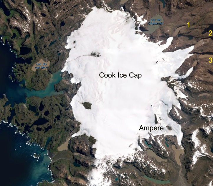
Kerguelen Island is at the edge of the furious fifties in the southern Indian Ocean. The island is host to many glaciers, the largest being the Cook Ice Cap at 400 km2. A comparison of aerial images from 1963 and 2001 by Berthier et al (2009) indicated the ice cap lost 21 % of its area in that period. The east side of the Cook Ice Cap outlet glaciers tetreat has led to formation and expansion of a new group of lakes (Pelto, 2016). Here we examine the changes from 2001-2025 along using Landsat and Sentinel imagery. 

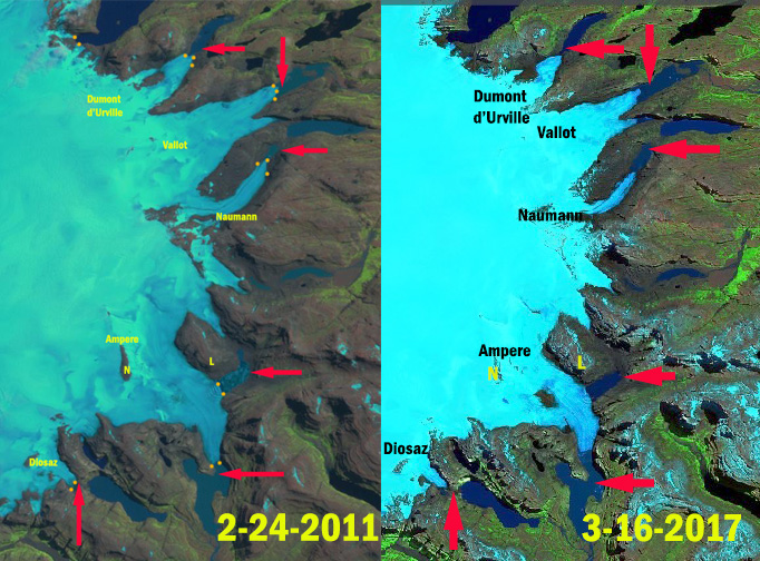
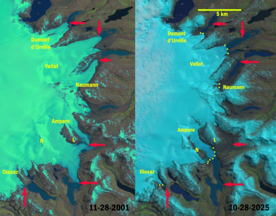
Ampere Glacier main terminus retreated 800 meters from 2001-2011. Here the terminus has pulled back from the tip of the peninsula on the west side of the terminus and is currently at a narrow point. The eastern terminus has retreated to its junction with the main Ampere Glacier a distance of 1400 m. From 2011 to 2025 the retreat accelerated totalling 3.3 km by 2025. The glacier had two nunataks L and N in 2001, by 2025 L has emerged as a marginal mountain and N is barely surrounded by ice.

Diosaz Glacier retreated 0.8 km from 2001-2025 leading to a small new lake basin developing.

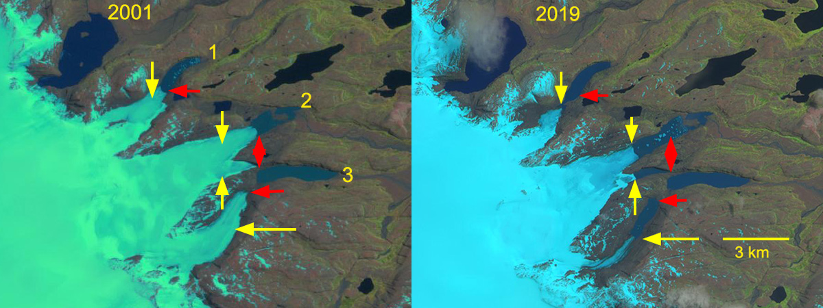
Naumann Glacier retreat has been 4.0 km from 2001-2025 creating an new alpine lake. With the glacier no longer terminating in the lake retreat should slow.

Vallot Glacier has retreated 2.4 km creating a new alpine lake at its southern terminus. The glacier will have just one terminus in the near future and the two lake basins could merge.

Dumon d”Urville Glacier has retreated 1.5 km with the lake it terminates in developing an expanding southern embayment.

The east side of the Cook Ice Cap on Kerguelen Island outlet glaciers retreatn and expanding group of lakes illustrates widespread ice cap thinning (Pelto, 2016). Verfaillie et al (2016) identified that the accelerating glacier wastage on Kerguelen Island was due to reduced net accumulation and resulting rise in the transient snowline since the 1970s, when a significant warming began. 

Cook Ice Cap in 2011 Landsat and 2017 Sentinel image. Red arrows indicate 2001 terminus positions and orange dots the 2011 terminus position.

Kerguelen Island Glacier Retreat Expands Lake District

Eastern Outlet glaciers of Cook Ice Cap in a 2001 Landsat and 2019 Sentinel image indicating retreat from 2001 terminus positions (red arrows) to 2019 terminus location (yellow arrows).

The east side of the Cook Ice Cap on Kerguelen Island outlet glaciers have retreated expanding and forming a new group of lakes (Pelto, 2016).  Here we examine the changes from 2001-2019 along using Landsat and Sentinel imagery. Retreat of glacier in the region was examined by Berthier et al (2009) and is exemplified by the retreat of Ampere Glacier.  Verfaillie et al (2016) examined the surface mass balance using MODIS data, field data, and models.  The accelerating glacier wastage on Kerguelen Island was observed do be due to reduced net accumulation and resulting rise in the transient snowline since the 1970s, when a significant warming began.  This has led to nunatak expansion on the ice cap.

In 2001 the northern outlet glacier terminates in a wide portion of the proglacial lake #1.  The central outlet, #2, has two terminus locations the northern is in a proglacial lake that is 2.5 km long and the southern arm terminates on land.  The southern outlet terminates on land.  By 2011 the northern outlet has retreated into a narrow section of the proglacial lake. The center terminus has retreated with a new lake forming in front of its southern arm. The southern outlet has retreated revealing a new developing lake.  In 2014 the northern terminus has retreated from the primary proglacial lake. The central terminus is producing icebergs from both arms. The lake continues to expand at the southern outlet.  The 2019 image is from early in the melt season. The northern terminus has retreated 1100 m since 2001 and is no longer calving in a substantial lake. The central terminus has retreated with the northern and southern arm retreated 1500-1800 m, with a new lake forming in front of the southern arm.  The southern outlet glacier has retreated the most, 2100 m since 2001, leading to the formation of a new lake of the same length. Outlet glaciers of the ice cap that are not calving are also retreating indicating that the retreat has been driven by rising snowline and enhanced by calving. The central and southern outlets continue to calve and should continue retreat more rapidly than the northern outlet.

Eastern Outlet glaciers of Cook Ice Cap in a 2011 and 2014 Landsat images indicating retreat from 2001 terminus positions (red arrows) to 2019 terminus location (yellow arrows).

Digital Globe image of the Cook Ice Cap, with the main outlet, Ampere Glacier and the three glaciers examined here 1-3.