Yalik Glacier, Alaska Retreat and Lake Expansion 1986-2019

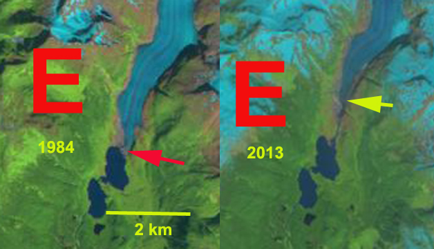
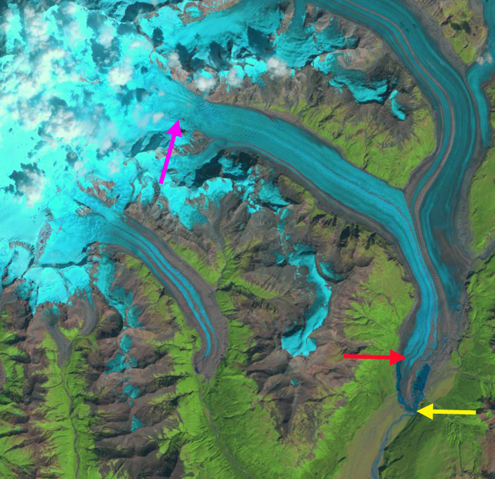
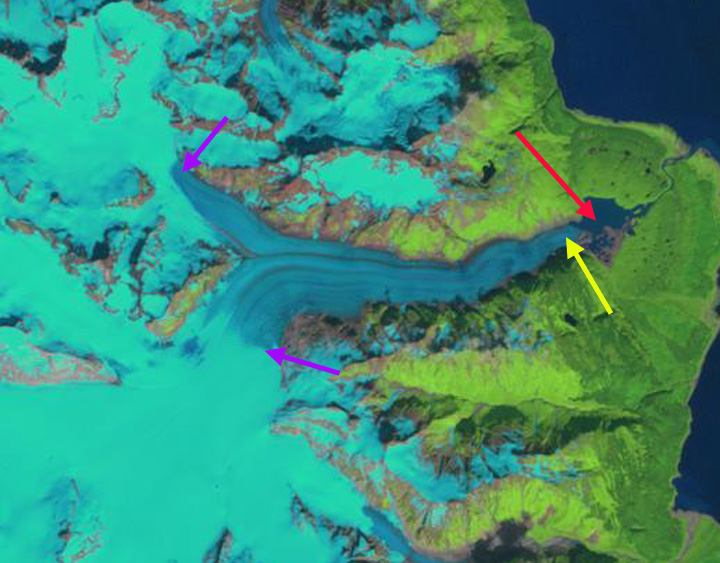
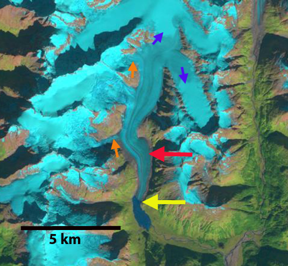
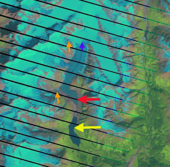
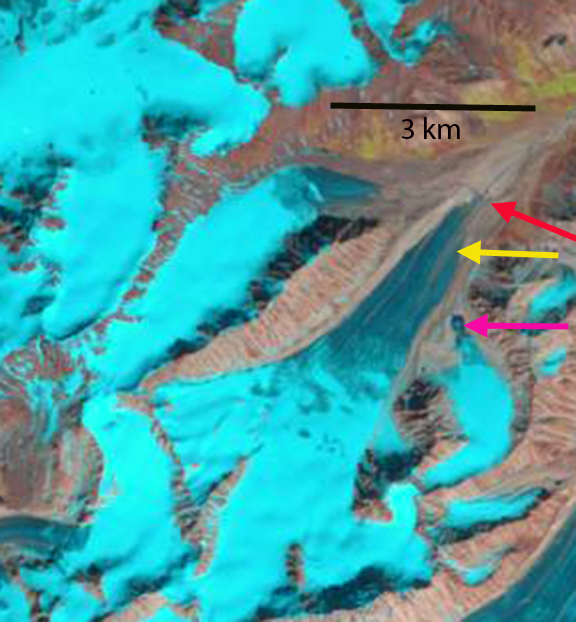
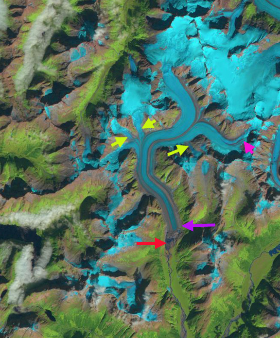
Yalik Glacier (Y) in 1986 and 2019 Landsat images.  Red arrow is the 1986 terminus location and yellow arrow the 2019 terminus location. Petrof Glacier (P) is the western neighbor.

Yalik Glacier drains an icefield on the Kenai Peninsula, glaciers draining east are in the  Kenai Fjords National Park, which has a monitoring program.  From 1950-2005 all 27 glaciers in the Kenai Icefield region examined  retreated (Giffen et al 2014).  Yalik Glacier retreated 1057 m from 1950-1986, a rate of-29 m/year and 797 m from 1986-2000, a rate of 57 m/year (Giffen et al 2014).  Here we update the retreat using Landsat images from 1986, 2000, 2018 and 2019.

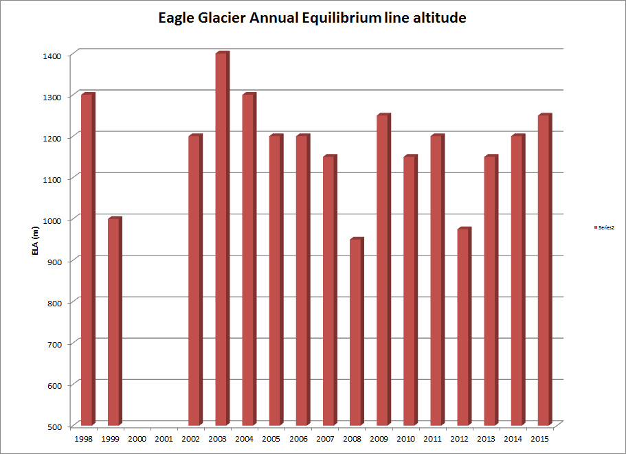
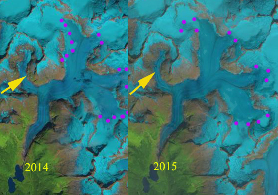
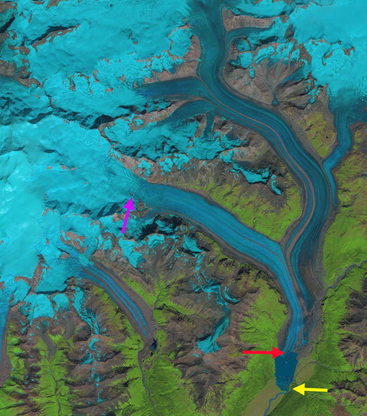
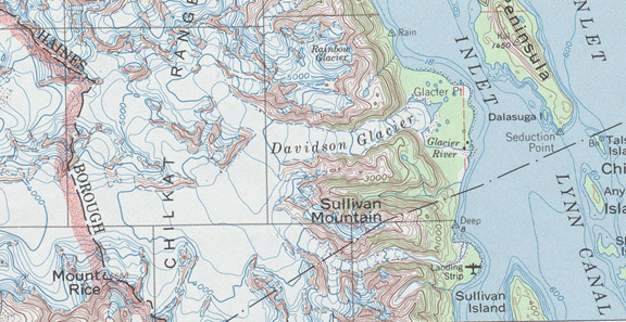
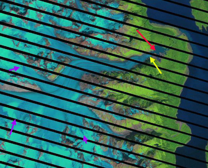
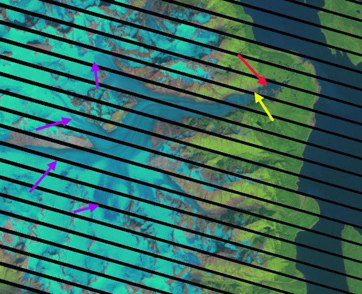
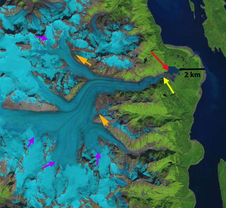
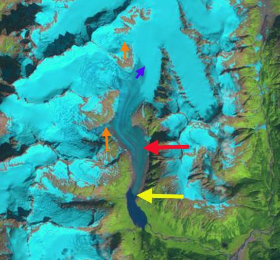
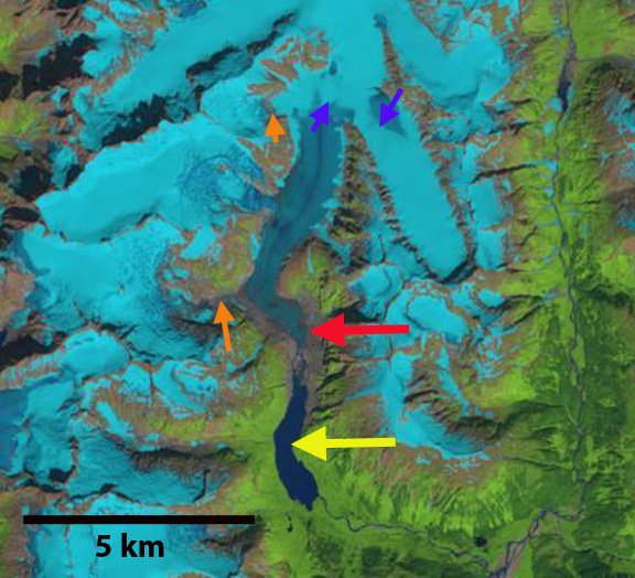
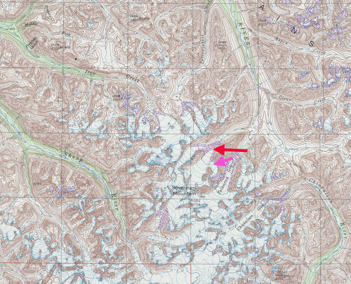
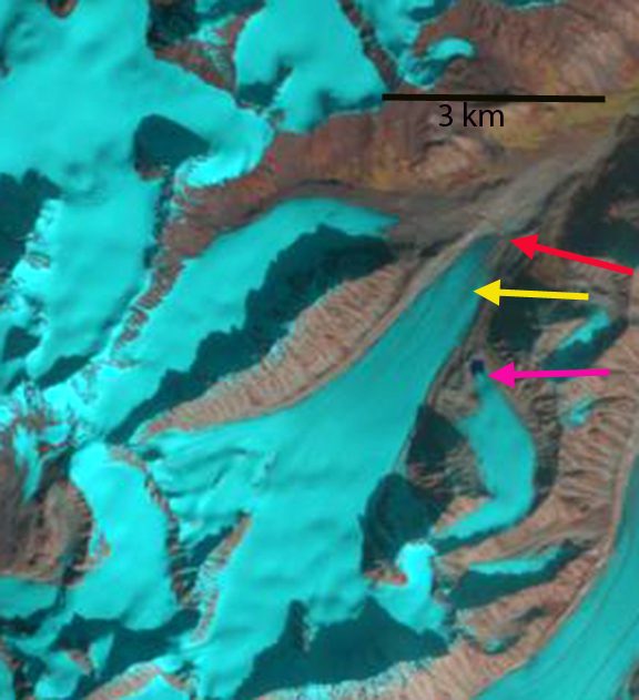
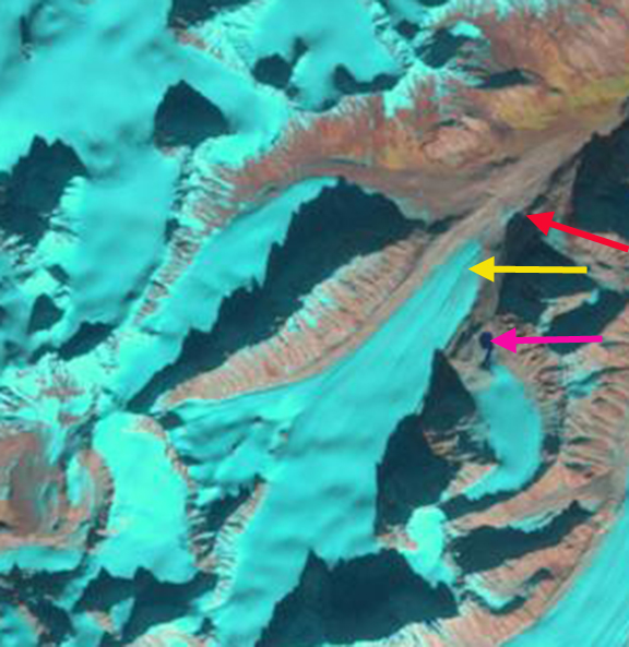
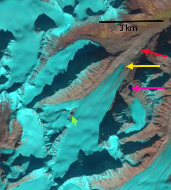
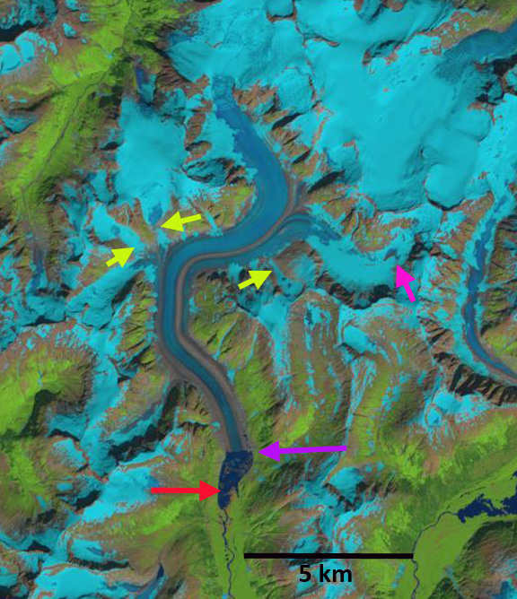
In the 1950 USGS map of the region Yalik Glacier terminates on a braided outwash plain, and does not have a proglacial lake.  By 1986 there is a 300-400 m wide fringing proglacial lake particularly on the eastern margin with an area of 0.6 km2. The glacier has retreated from the outwash plain into the developing proglacial lake basin.  By 2000 the proglacial lake has expanded to 1.3 km2 due to the ~800 m retreat.  In 2018 the proglacial lake has expanded to 2.1 km2 and a second proglacial lake has formed on the eastern margin.  This proglacial lake will merge with the main lake as the terminus retreats from a peninsula extending from the eastern margin. A bedrock knob has emerged east of Point 1 indicating substantial glacier thinning since 2000. In 2019 the total proglacial lake area is 2.4 km2.  The glacier has retreated 1500 m since 1986 and 700 m since 2000, the latter period has a retreat rate of 34 m/year.  The former braided river  that exited the glacier is now a single meandering stream channel as it leaves the proglacial lake. The retreat of Yalik Glacier is more than nearby Grewingk Glacier and less than nearby Excelsior Glacier.

What is driving the retreat is continued warming including warm summers.  The glacier generated few icebergs during this retreat, indicating melting not calving is the key factor. The 2019 Alaska Climate Review indicates 2019 was the state’s warmest year, see Anchorage example from this report below. Temperatures in nearby Homer averaged 4.2 F above normal with June-August averaging 4.4 F above normal.  These conditions also led to forest fires in the area reducing the 2019 image clarity due to forest fire smoke from the Swan Lake fire that burned ~167K acres.

Yalik Glacier in 2000 and 2018 Landsat images.  Red arrow is the 1986 terminus location and yellow arrow the 2019 terminus location. Point 1 is west of a bedrock knob that has emerged due to glacier thinning.

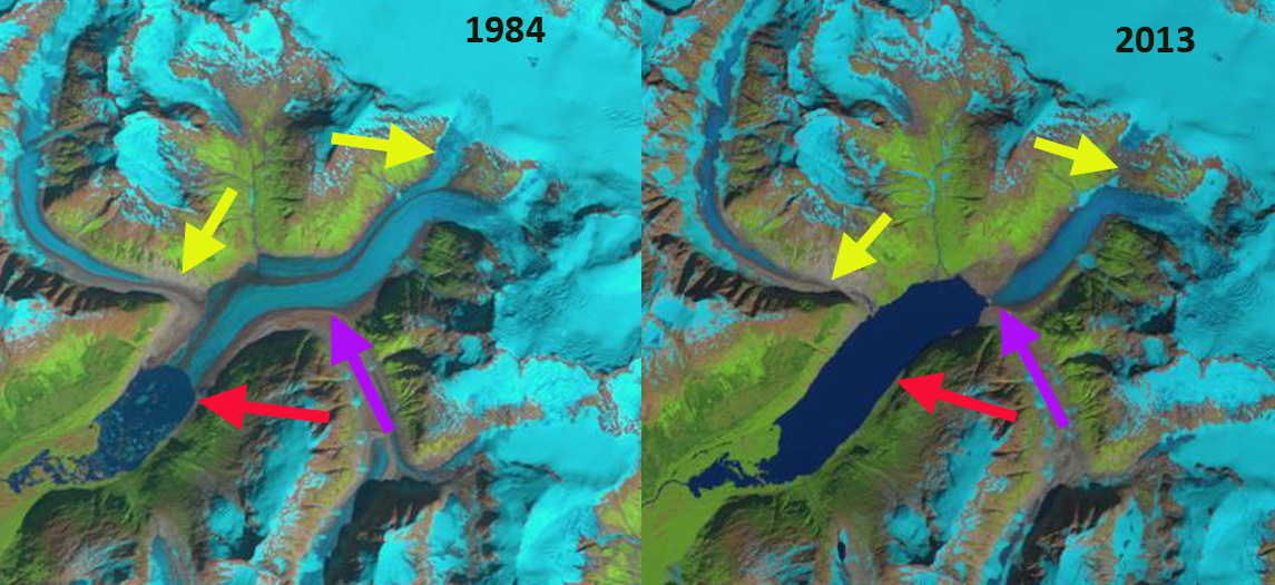
USGS map of Yalik Glacier in 1951

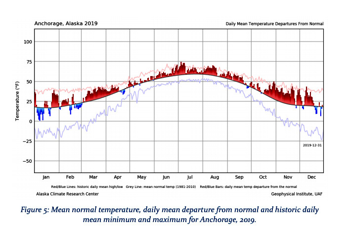
From the 2019 Alaska Climate Review .

Eagle Glacier, Alaska Retreat Losing a Wing

eagle glacier change

Above is a paired Landsat image from 1984 left and 2013 right indicating the 1100 m retreat during this period of Eagle Glacier.

My first visit to the Eagle Glacier was in 1982 with the, ongoing and important, Juneau Icefield Research Program, that summer I just skied on the glacier. In 1984 we put a test pit at 5000 feet near the crest of the Eagle Glacier to assess the snowpack depth. This was in late July and the snowpack depth both years was 4.3 meters, checking this depth in nearby crevasses yielded a range from 4-4.5 meters.In 1984 the snowline at the end of the summer melt season in early September was at 1050 meters.The equilibrium line altitude (ELA) which marks the boundary between the accumulation and the ablation zone each year. On Eagle Glacier to be in equilibrium the glacier needs to have an ELA of 1025 meters. In the image below the glacier is outlined in green, the snowpit location is indicated by a star and the snowline that is needed for the glacier to be in equilibrium at 1025 meters is indicated. The number of years where the ELA is well above 1050 meters dominate since 2002, all but two years see chart below, leading to mass loss, thinning and glacier retreat. This follows the pattern of Lemon Creek Glacier that is monitored directly for mass balance, which has lost 26 meters of thickness on average since 1953.The more rapid retreat follows the pattern of more negative balances experienced by the glaciers of the Juneau Icefield (Pelto et al. 2013). The high snowlines have left the western most tributary with no retained snowpack in 2013, 2014 and 2015, yellow arrow in the 2014 and 2015 Landsat image.  This will lead to the rapid downwasting of this tributary.

Eagle Glacier has experienced a significant and sustained retreat since 1948 when it terminated near the northern end of a small lake.  By 1982 when I first saw the glacier and when it was mapped again by the USGS the glacier had retreated to the north end of a second and new1 kilometer long lake. In the image below the red line is the 1948 terminus, magenta line the 1982 terminus, green line 2005 terminus and orange line the 2011 terminus. From 1984 to the 2005 image the glacier retreated 550 meters, 25 meters/year. From 2005-2015 retreat increased to 60 meters/year. Going back to the 1948 map the terminus in 2011 is located where the ice was 150-175 m thick in 1948. The high snowlines in 2014 and 2015 along with extended melt season continued the rapid retreat.  Total retreat from 1984-2015 is now 1200 m. The retreat hear is less rapid than on nearby Gilkey Glacier or Antler Glacier, but the upglacier downwasting is more severe than at Gilkey Glacier.

Snowline location and snowpit location in 1984

eagle ela
ELA of Eagle Glacier from Landsat images.

eagle wing compare

2014 and 2015 Landsat image indicating snowline on Eagle Glacier, purple dots. Yellow arrow indicates tributary that lacks any retained snowpack,

Terminus change map on 2005 Google Earth image.  Red line is 1948, magenta line is 1982, green line is 2005 and orange line is 2011. 

Shamrock Glacier, Alaska Loses Terminus Tongue

shamrock glacier compare
Shamrock Glacier comparison in 1987 and 2014 Landsat images. Red arrow 1987 terminus, yellow arrow 2014 terminus, purple arrows upglacier thinning and purple dots the snowline. The terminus tongues extending into the lake has been lost.

Shamrock Glacier flows north from the Neacola Mountains into Chakachamna Lake in the Lake Clark National Park of Alaska. This lake is transited by several species of salmon, mainly sockeye, heading into spawning  areas upriver. The lake had been the site of a proposed hydropower plant, that would not have required building of a dam, but this project is currently not being developed. The National Park Service completed a Southwest Alaska Network mapping project that identified the changes of glaciers in the region. Lake Clark NP has 1740 glaciers which have lost 12% of their total area from 1950 to 2009 (Loso et al, 2014). Here we examine Landsat imagery from 1987 to 2014 to identify recent change of Shamrock Glacier.

shamrock glacier profile
July 2015 image looking across Shamrock Lake to Shamrock Glacier, taken by Jerry Pillarelli, note he has many more gorgeous images of area. The trimline on the far side of the glacier between sediment and vegetation indicates the 1950 margin. There is an elevation step several hundred meters inland of the terminus indicating Shamrock Lake will expand little.

In 1987 Shamrock Glacier had receded from a terminal moraine in Chakachamna Lake that it had terminated on in the 1950’s map. The new proglacial lake was less than 500 m across. The snowline was at 1200 m. In 2000 seen below the snowline was at 1350 m, and the terminus had narrowed more than it had retreated. By 2014 the terminus had retreated 900 m leaving the new Shamrock Lake within Chackachamna Lake. The new Shamrock Lake has an area of 4 square kilometers. This is the majority of the loss in glacier area since 1950 as well. In 2014 the snowline is quite high at 1450 m. A snowline that is consistently above 1300 m will drive continued retreat. Thinning upglacier is evident with expanded bedrock areas adjacent to the glacier margin above 1200 m at the purple arrows, indicating the snowline has been consistently higher than this. The retreat is similar to other glaciers in the region South Sheep Glacier, Sovereign Glacier and Fourpeaked Glacier.  With the glacier retreating out of the lake basin soon, the rate of retreat should decline.

shamrock glacier 2000
2000 Landsat image

shamrock glacier ge 2013
2013 Image of Shamrock Glacier, Shamrock Lake and Chakachamna Glacier.


Nizina Glacier Retreat, Lake Formation, Alaska

If you have heard of Nizina Glacier in the Wrangell Mountains of Alaska it is probably because you have contemplated a float trip down the Nizina River from Nizina Lake.  In 1990 there was no lake, since 2000 the lake has provided a good location for float planes to land.  In 2014 the lake has reached a new maximum in size and minimum in icebergs on its surface.  Here we examine Landsat imagery form 1990-2014 to identify changes in the Nizina Glacier.  The main tributary of the Nizina Glacier is Regal Glacier indicated by the dark blue flow arrows.  The light blue flow arrows are from the Rohn Glacier tributary that no longer reaches the terminus area.

nizina ge

Google Earth image

In each image the yellow arrow marks the 1990 terminus, red arrow the 2014 terminus location and pink arrows the summer snowline.  In 1990 the glacier had narrow sections of fringing lake evident, though the glacier reached the southern shore of the developing lake at yellow arrow.  By 1995 the lake had developed to a width of 100-300 m fringing the shoreline around the terminus of Nizina Glacier.  In 1999 the main lake has developed and is 1.6 km long and 1.3 km wide though it is still largely filled with icebergs.  In 2013 there are a few icebergs left in the lake.  In August, 2014 the lake is free of icebergs for the first time, which does mean more will not form. The lake is 1.4 km wide and 2.3 km long.  The glacier has retreated 2.1 km from 1990 to 2014, a rate of 150 m per year, red arrow marks 2014 terminus. A close up view of the terminus in Google Earth from 2012 indicates numerous icebergs but also substantial rifts, green arrows, that will lead to further iceberg production and retreat.  The snowline in this late July or early August images is typically at 1800-1900 m, pink arrow, with a month still left in the melt season. The retreat of this glacier is similar to that of glaciers in the Talkeetna Range to the west South Sheep Glacier and Sovereign Glacier and Valdez Glacier to the south.

nizina glacier 1990

1990 Landsat image


nizina glacier 1995

nizina glacier 19991995 Landsat image

nizina glacier 1999

1999 Landsat image

nizina glacier 2013

2013 Landsat image

nizina glacier 2014

2014 Landsat image

nizina lake 2012

Google Earth image 2012


Davidson Glacier Retreat, Alaska

Davidson Glacier is a large glacier that flows east from the Chilkat Range to the foreland along Chilkat Inlet and Lynn Canal in southeast Alaska. As a result it has a long history of observation of change. Molnia (2008) noted that from 1889 to 1946 the glacier retreated 400 m and a lake had developed at the terminus. By 1978 the glacier had retreated another 700 m with the proglacial lake at the terminus further expanding. Molnia (2008) futher observed a 700 m retreat by 2004. Here we examine Landsat imagery from 1993 to 2014 to identify recent changes of the glacier.

davidson map
USGS map

davidson ge
Google Earth Image

In 1984 the glacier terminated at the end of a peninsula extending from the south side of the proglacial lake, red arrow. The purple arrow is the snowline at 1100 m. The orange arrows indicate two tributaries feeding the main glacier. By 2001 the terminus has retreated 500 m into a narrower western section of the lake. In 2004 the snowline is at 1250 m, leaving little accumulation area. In 2009 the snowline is at 1200 m. The terminus has retreated from the proglacial lake. In 2013 the snowline is at 1100 m, there is a river connecting the terminus at the yellow arrow to the proglacial lake. The glacier no longer reaches the foreland having retreated into a mountain valley. In 2014 the snowline was at 1300 m at the start of August with a month left in the melt season. The two tributaries at the orange arrows only have a thin connection to the main glacier. The terminus has retreated 800 meters from 1984 to 2014. The retreat will continue due to the high snowlines in recent years and tributary separation. The retreat is less than most nearby glaciers such as Sinclair Glacier or Ferebee Glacier, just east across Lynn Canal.

Johnson et al (2013) compare changes in Davidson and Casement Glaciers that share a flow divide at 1200 m, Casement Glacier flows west and Davidson Glacier flows east. Both glaciers thinned at a rate of 1 m per year at the flow divide from 1995-2011. This is an indication of the high snowlines and negative glacier mass balance. Casement Glacier had a much greater thinning below 600m than Davidson Glacier, which leads to greater retreat. The difference is that Davidson Glacier has a steeper gradient from the terminus than most glaciers. davidson 1984
1984 Landsat image
davidson 2001
2001 Landsat image
davidson 2004
2004 Landsat image
daidson 2009
2009 Landsat image
davidson 2013
2013 Landsat image
davidson 2014
2014 Landsat image

Sinclair Glacier Retreat, Alaska

Sinclair Mountain is on the east side of the Lynn Canal in southeast Alaska. The mountains hosts too substantial glacier, the south flowing unnamed glacier is referred to here as Sinclair Glacier. This glacier terminated in a lake in the 1982 map of the Skagway region. I observed this glacier from the air in 1982 and it was ending in this lake. Here we examine Landsat imagery from 1984 to 2014 to identify changes. sinclair map
USGS Skagway map
Sinclair ge
Google Earth Image

In 1984 the glacier ended at a prominent peninsula in the lake, red arrow in each image, the lake was 1700 m long. The snowline was at 950 m, indicated by the purple arrow, this was at the end of the melt season. The glacier was joined by two tributaries from the west side, orange arrows. In 1986 there is a small amount of terminus retreat visible. By 2001 the glacier has retreated out of the lake, which is 2.9 km long. By 2004 the southern tributary at the orange arrow is no longer connected to the glacier. The glacier has retreated 1.3 km from 1984-2004. The snowline is at 950 m with a month left in the melt season. In 2009 the image is not great quality, but the northern tributary is still connected to the main glacier by a thin tongue of ice at an icefall at 850 m. By 2013 the northern tributary is no longer connected to the main glacier, there is bare rock extending across the full width of the former icefall area. In 2014 the image is from the end of July and the snowline is already above 950 m. It is evident that the glacier will lose nearly all of its snowcover by the end of the melt season on October 10th. The glacier has retreated 900 meters since 2004, and 2.2 km since 1984. The recent loss of tributaries indicates less contribution of ice to the glacier and that retreat will continue. This retreat is the same as that of nearby Field Glacier, Meade Glacier and Ferebee Glacier.
sinclair 1984

1984 Landsat image
sinclair 1986
1986 Landsat image
sinclair 2001
2001 Landsat image
sinclair 2004
2004 Landsat image
sinclair 2009
2009 Landsat image
sinclair 2013
2013 Landsat image
sinclair 2014
2014 Landsat image

Sovereign Glacier Retreat, Talkeetna Mountains, Alaska

Sovereign Glacier is on the northeast side of the Talkeetna Mountains, Alaska and drains into the Talkeetna River. The Sovereign Glacier, red arrow, was joined by a tributary from the south in the map image, pink arrow. Molnia (2007) noted that all glaciers in the region have retreated since the early 1950’s when the area was mapped and that all the major termini were retreating and thinning in 2000. Here we examine Landsat imagery from 1986 to 2014.
talkeetna_mountains-1983
In 1986 the glacier terminates at the red arrow at the valley junction. The tributary to the south, pink arrow has separated from the main glacier and ends in a proglacial lake. In 1989 retreat is evident during the last three years with an expanding proglacial lake at the pink arrow, and the glacier terminus no longer reaching the valley junction, red arrow. By 2001 the glacier has retreated most of the distance from the red arrow at the 1986 terminus location to the yellow arrow, the 2014 terminus location. The former tributary glacier has receded from the proglacial lake. In 2009 there are two new outcrops of bedrock in the upper portion of the glacier indicating glacier thinning near the equilibrium line at 2000 m, at green arrow. By 2014 the main glacier has retreated 1100 m from the 1986 position, red arrow, to the yellow arrow. The tributary glacier at the pink arrow has retreated 400 m since 1986. The green arrow indicates further thinning of the upper glacier since 2009. The thinning upglacier indicates that retreat will continue. The retreat parallels that of nearby South Sheep River Glacier. This thinning in the upper glacier is similar to that of Lemon Creek Glacier as well (Pelto et al, 2013).
sovereign Glacier 1986
1986 Landsat image
sovereign Glacier 1989
1989 Landsat image

sovereign Glacier 2001
2001 Landsat image

sovereign Glacier 2009
2009 Landsat image

sovereign Glacier 2014
2014 Landsat image

South Sheep River Glacier Retreat, Alaska

South Sheep River Glacier is the informal name of the longest glacier in the Talkeetna Mountains of Alaska. This glacier is the headwaters of the Sheep River and is comprised of two major glacier branches from the east and west meeting and turning north down the Sheep River valley. Molnia (2007) noted that all glaciers in the region have retreated since the early 1950’s when the area was mapped. Molnia (2007) noted that all the major termini were retreating and thinning in 2000. Here we examine Landsat imagery from 1986 to 2014. In the early 1950’s the glacier extended 5.5 km north down the Sheep River Valley from the main glacier junction, red arrow.
sheep river glacier map
USGS Map
In each image the red arrow indicates the early 1950 terminus position, the yellow arrow the 1986 terminus and the pink arrow the 2014 terminus position. In 1986 the glacier had retreated 2.5 km from the 1950’s position. The terminus is at the mouth of the first significant glacier valley draining into the Sheep River from the west. The medial moraine extending to the terminus from the glacier junction is quite prominent. There is a small tributary at Point A that joins the eastern branch of the glacier. In 1989 the snowline on the glacier is at 1700 m. By 2001 the glacier has retreated substantially from the yellow arrow and side valley from the west. In 2009 the snowline is quite high at 2000 m. Th eastern tributary is quite thin beyond the junction, and adds little ice to the now short northward flowing segment. The late Sept. 2014 Landsat image is after a fall snowstorm and the snowline has lowered. The terminus is now at the pink arrow a 4.5 km retreat since the early 1950’s. The glacier has retreated 2 kilometers since 1986. The tributary at Point A now terminates 600 meters from the eastern branch. The glacier flows just 1 km north from the main junction versus 5.5 km in 1950. The terminus remains thin, and the narrow eastern tributary appears ready to separate from the west flowing tributary. This is not an imminent change, but is inevitable. The retreat is the same as that of nearby Sovereign Glacier and glaciers to the south, Pedersen Glacier and Fourpeaked Glacier
sheep river glacier 1986
1986 Landsat image

sheep river glacier 1989
1989 Landsat image

sheep river glacier 2001
2001 Landsat image

sheep river glacier 2009
2009 Landsat image

sheep river glacier 2014
2014 Landsat image

Fourpeaked Glacier Retreat, Katmai area, Alaska

Fourpeaked Glacier drains east from the volcano of the same name in the Katmai region of southern Alaksa. The Park Service in a report (Giffen et al 2008) noted that the glacier retreated 3.4 km across a broad proglacial lake that the glacier terminates in from 1951-2986, a rate of 95 m/year. From 1986-2000 they noted a retreat of 163 m, or 13 m/year. In a more recent report with the Park Service Arendt and Larsen (2012) provide a map of the change in glacier extent from 1956-2009, Figure 4, but note the poor data overall on historic changes of Fourpeaked. Here we utilize Landsat imagery to examine retreat from 1981 to July 2014.
fourpeaked ge
Google Earth image
A Landsat 2 image from 1981 with relatively low resolution indicates much of the proglacial lake still occupied by ice, but much of this is floating icebergs detached from glacier, which is hard to distinguish in this image. In each image the red arrow is the 1985 terminus and the yellow arrow is 2013-2014 terminus. In 1985 the terminus is at the red arrow, with considerable floating ice still evident that is not part of the glacier. The snowline, purple dots, is at 750-800 m though this is not near the end of the summer. By 2000 the floating ice is gone, and the terminus has retreated into a narrower inlet. The snowline is at 850 m. By 2013 the glacier has receded further up this inlet and the width of the lower glacier is less. This is a July image and the snowline is still relatively low. In the July 2014 image the snowline is quite high at 700 m, given that this is mid-summer. It is not apparent in the Landsat image, but the large local forest fires in the spring could reduce albedo and enhance melt this summer. The terminus has retreated 1.9 km from 1986 to 2014 a rate of 68 m/year. The retreat from 1981-2000 was fed by calving in a broad proglacial lake. From 2000-2014 the retreat has continued despite the narrowing of the calving front. That the glacier has narrowed even more and thinned in the lower reach is indicative of a retreat that will continue. This glacier is behaving like other Katmai area glaciers, Giffen et al (2008) noted that 19 of 20 are retreating. The glacier retreat has led to formation and expansion of a large lake much like other glaciers in the region; Bear Glacier, Excelsior Glacier and Pedersen Glacier. The last image is an animated gif created by Espen Olsen illustrating the change in the glacier. Katmai 1981
1981 Landsat image

katmai 1985
1985 Landsat image

katmai 2000
2000 Landsat image

katmai 2013
2013 Landsat image

katmai 2014
2014 Landsat image

mauri
Espen Olsen animated gif of Landsat images

Wright Glacier Retreat, Southeast Alaska

Wright Glacier is the main glacier draining a small icefield just south of the Taku River and the larger Juneau Icefield. Wright Glacier is 60 km east of Juneau and has ended in a lake since 1948. A picture of the glacier in 1948 from the NSIDC collection indicates the terminus mainly filling the lake, but breaking up. The glacier drains the same icefield as the retreating West Speel and Speel Glacier. The dark blue arrows indicate the flow vectors of Wright Glacier, light blue arrows flow vectors for adjacent glaciers. Despite being 30 km long this glacier has been given very little attention, maybe because it does not reach tidewater.
wright glacier1948080301
NSIDC Glacier Photograph Collection Photographer unknown.

wright glacier ge
Google Earth view

In 1984 the glacier ended at a peninsula in the lake where the lake turns east. This was my view of this glacier during the summers of 1981-1984 from the Juneau Icefield with the Juneau Icefield Research Program. Our bad weather came from that direction so keeping an eye on that region during intervals between whiteout weather events, the norm, was prudent. Here we examine Landsat imagery from 1984-2013 to document the retreat of Wright Glacier and the elevation of the snowline on the glacier. The red arrow indicates the 2013 terminus, the red arrow the terminus at the time of the image and the red dots the snowline on the date of the imagery. In 1984 the lake had a length of 3.1 km extending northwest from the glacier terminus. The snowline in mid-August with a month left in the melt season was at 1150 m. By 1993 the glacier had retreated little on the north side of the lake and 200 m on the south side. The snowline in mid-September close to the end of the melt season was at 1150 m. In 1997 the fourth in a five year run of extensive mass balance losses and high equilibrium lines in the region, noted on the Juneau Icefield (Pelto et al, 2013), the snowline had risen to 1450 m. The terminus had retreated 200 m on the north side since 1984 and 600 m on the south side. In 2003 the snowline was at 1250 m with a month left in the melt season. The terminus retreat on the north side and south side since 1984 had now evened out with 900 m of retreat. In 2013 the snowline was at 1150 m in mid-August and 1350 m by the end of the melt season. The terminus had retreated 1300 m since 1984 and the lake is now 4.5 km long. The lower 2 km of the glacier has many stagnation features on it, suggesting continue retreat. It is unclear how far the basin that will be filled by the lake upon retreat extends, but it is not more than 2 km from the current terminus, as a small icefall reflecting a bedrock step occurs there. This glaciers retreat has accelerated since 1984. To be in equilibrium the glacier needs a minimum of 60% of its area to above the snowline at the end of the melt season. This is to offset the 10-12 m of melt that occurs at the terminus. This requires a snowline no higher than 1150 m. The snowline has been above this level in 1994-1998, 2003-2006 2009-2011 and in 2013, which suggest the glacier cannot maintain its current size and will continue to retreat. The glacier has a larger high elevation than the West Speel and Speel Glacier that originate from the same mountains. The glacier is following the pattern of retreat of all but one of the glaciers of the Juneau Icefield.

wright glacier 1984
1984 Landsat image

wright glacier 1993
1993 Landsat image

wright glacier 1997
1997 Landsat image

wright glacier 2003
2003 Landsat image

wright glacier 2013
2013 Landsat image

West Speel Glacier Retreat and Lake Formation, Southeast Alaska

West Speel Glacier is an unnamed glacier that drains the same icefield as the Wright and Speel Glacier 45 km southeast of Juneau, Alaska. Here we examine the changes in this glacier from 1984-2013 using Landsat imagery. west speel glacier ge
Google Earth image

In 1984 the glacier ended on an outwash plain at the head of a branch of Speel River. The red arrow indicates the 1984 terminus for each image, the purple arrow the 2013 terminus and the yellow arrows tributary glaciers. In 1984 all three tributary glaciers fed West Speel Glacier and the glacier has no proglacial lake at the terminus. The eastern tributary pink arrow has some retained snowpack with three weeks left in the melt season. Each tributary indicated by yellow arrow is still contributing to the glacier. In 1997 a lake basin is beginning to develop, though it is still largely filled by ice. The eastern tributary pink arrow, has lost all of its snowpack. In 1999 the proglacial lake has formed and has length of 1 km, the lake has expanded south and north of the 1984 terminus position, and does not entirely represent glacier retreat. The noted tributaries are still all connected to the main glacier. In 2013 the glacier has retreated 1200 m from the 1984 position and the lake is still expanding. The yellow arrows indicate that none of the three tributaries are still connected to the main glacier. The glacier in a sense is losing its income flow from these subsidiaries. The eastern tributary has retained some snowcover with six weeks left in the melt season in 2013, but this is mostly gone a month later. The melt season is off to a quick start in 2014, which promises to be a poor year for this glacier. The retreat of this glacier is the same story as seen at nearby Speel, Gilkey and Norris Glacier. west speel glacier 1984
1984 Landsat image
west speel glacier 1997
1997 Landsat image

west speel glacier 1999
1999 Landsat image

west speel glacier 2013
2013 Landsat image

west speel 2013sept
Sept. 2013 Satellite image

Speel Glacier Retreat, Coast Range Alaska

speel glacier 1984-2013
Speel Glacier a 3.2 km retreat from 1984-2013, lake expansion and tributary separation.
In 1984 I had a good chance to observe Speel Glacier while flying into Juneau, AK to work with the Juneau Icefield Research Program on the Juneau Icefield. Speel Glacier is south of the Taku Inelt east of Juneau, Alaska. Unlike the map on my lap, there was now a big lake at the terminus of the glacier. This post examines the retreat of this remote glacier and the expansion of the unnamed lake at its terminus. In 1948 Speel Glacier ended at the head of a braided outwash plain, generated by the Speel River. Upglacier in 1948 there was a lake impounded by the glacier, Speel Lake. speel glacier juneau Today Speel Lake is gone and a much larger proglacial lake exists. The lower part of the glacier was heavily debris covered and stagnant in 1948. By 1968 the glacier had retreated 1 km just to the edge of the current lake. In 1984 the lake was 2.2 km long. In the images below Landsat 1984, Google Earth 2003, Landsat 2006, Landsat 2009 and 2013, the primary accumulation zone is marked ACC, secondary accumulation areas are indicated by black arrows, the 1984 terminus pink arrow, 2003 terminus blue arrow, 2006 terminus green arrow, 2009 terminus yellow. In the 1984 Landsat image the glacier had retreated 2 kilometers from the 1968 position and was fed by a shared accumulation zone with the Wright Glacier-black arrows in addition to the main accumulation area of the glacier above the main icefall on the east side of the glacier. By 2003 the glacier had retreated 1.9 km to where the lake bends east, and the main tributary from the north separated from the glacier. In the 2006 imagery the glacier has retreated an additional 1.8 km. The connections with the Wright Glacier accumulation area had been lost. The tributary from the north that has its own accumulation zone was now completely separated. The glacier was then solely dependent on a single accumulation zone, ACC. In 2009 the glacier had retreated 200 meters from 2006. By 2013 the glacier had retreated from the lake entirely a 6 km retreat since 1948. This should lead to a reduced rate of retreat.

The rapid retreat of this glacier has reduced its area at low elevation considerably. This is improving the glaciers accumulation area ratio, to be in equilibrium the glacier needs at least 60% of its area to be in the accumulation zone, in this region Pelto (1987) noted that no glaciers in the region were advancing that did not have an accumulation area ration above 67. In 1984 the accumulation area ratio was 48. In 2006 the AAR is 54, ablation area is being lost faster than accumulation area. The icefall marks the boundary between the ablation zone and the accumulation zone.The retreat of this glacier fits the pattern of other glaciers in the region Eagle, Field, Gilkey, and Chickamin. Today the lake averages nearly 1.5 km in width and is over 5 km long.
Landsat imagery 1984

2003 Google Earth image

Landsat imagery 2006

2009 Landsat image
speel glacier 2013
2013 Landsat image- Red arrow is 1984 terminus, purple the 2013 terminus and yellow arrows detached former tributaries.