Volcan Overo Glaciers, Argentina Lack Accumulation Zone Cannot Survive

Volcan Overo Glaciers at the end of the 2024 melt season in a false color Sentinel image from 3-30-2024. There is no sigificant area of snowcover remaining for the 3rd consecutive summer. The lake that had formed at Point A since 2018 has now drained. Fragmentation at point B, C, and D continue, while thinning at top of glacier is apparent with expanding bedrock knob at Point E.

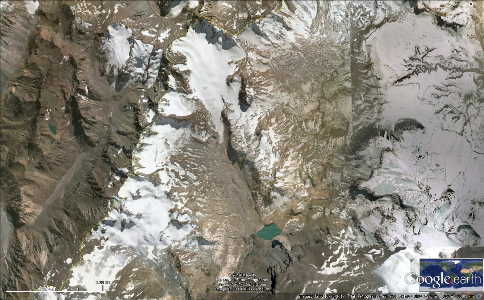
Volcan Overo is a 4619 m high Andean mountain in Argentina with a relatively low sloped broad volcanic summit region above 4000 m that hosts a glacier complex that is shrinking and fragmenting.  La Quesne et al (2009) observed significant annual thinning in the latter half of the 20th century on nearby glaciers in Argentina and Chile. A sharp increase in mass loss on Central Andean glaciers after 2009, including the Volcan Overo region, was reported by Ferri et al (2020). Here we examine Landsat images from 1986-2022 to identify longer term changes of the glacier and Sentinel images from 2018-2024 illustrating the persistent lack of an accumulation zone leading to recent changes, including the impact of the January 2023 heat wave (Washington Post, 2022). The persistent lack of an accumulation zone during the 2018-2024 period, highlighted in images below, in which no snow was retained as firn, indicates the glacier cannot survive (Pelto, 2010).

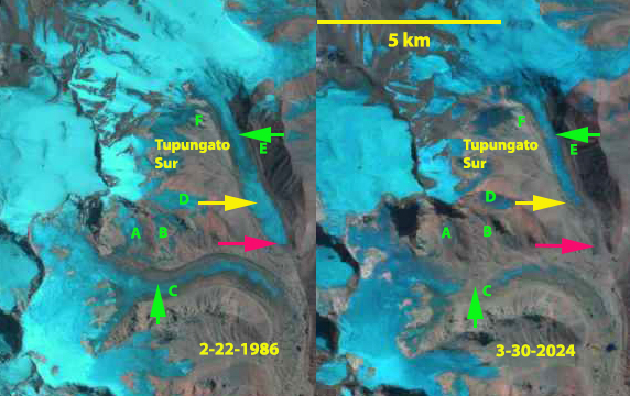
Volcan Overo in Landsat images from 1986-2022 illustrating area loss and fragmentation.

In 1986 there are four discrete glaciers around the caldera, covering ~12 km2 the largest E around the summit ranges in elevation from 4200-4500 m.  D is an isolated area at 4000-4100 m. A,B and C is a single glacier extending from 3900-4300 m. F is an area of rapidly diminishing glacier ice.

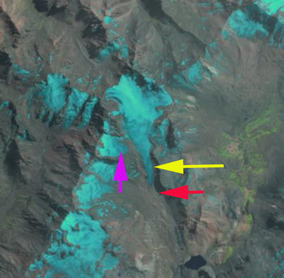
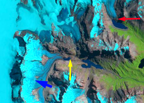
In the early February image snowcover is good across all ice areas except F. In 2003 there is limited evident change with good snowcover across all except D. By 2013 A, B and C have fragmented into three separate glaciers and F is nearly gone. Only E has significant snowcover.

In 2022 C and D in the Landsat images have declined to less than 50% of their 1986 area, the overall Volcan Overo glaciated area has declined to ~8.1 km2.  It is not quite mid-summer on January 8, 2022 yet all snowcover has been lost from the glaciers of Volcan Overo. The glacier remnants at F are now gone.

Volcan Overo Glaciers at the end of the 2018 melt season in a false color Sentinel image from 3-17-2018. There is no sigificant area of snowcover remaining. A lake is forming at Point A . At Point B this is a single glacier. At Point C an expanding ridge is still narrow and segmented. At Point D three glaciers areas are just losing contact and at Point E a small knob has emerged from ice cap.
Volcan Overo Glaciers at the end of the 2020melt season in a false color Sentinel image from 3-11-2020. There is no sigificant area of snowcover remaining. A lake has formed at Point A . At Point D three glaciers areas are clearly separated.
Volcan Overo Glaciers at the end of the 2022 melt season in a false color Sentinel image from 3-09-2022. There is no sigificant area of snowcover remaining. The lake at Point A is expanding . At Point B the glacier is separating into two parts.. At Point C an expanding ridge is now continuous segmented.
Volcan Overo Glaciers at the end of the 2023 melt season in a false color Sentinel image from 3-09-2023. There is no sigificant area of snowcover remaining for the 2nd consecutive summer. The lake that had formed at Point A has expanded further. Fragmentation at point B, C, and D continue.

The impact of heat waves in 2022 and 2023 has taken its toll on the glacier.

Upsala Glacier Separation from Bertacchi Glacier, Argentina

Upsala Glacier (U) in Landsat images from 1999, 2016 and 2021 illustrating both retreat and the separation from Bertacchi Glacier (B). Cono Glacier (C) is the next tributary to the north.

Upsala Glacier is a major outlet glacier of the Southern Patagonia Icefield. The glacier terminates in Lago Argentina and retreated substantially, 7.2 km from 1986-2014 (NASA, 2014). The retreat accelerated after 2008 (Sakakibara et al 2013). From 2014-2019 the rapid retreat had slowed, but given mass losses upglacier and consistent high snowlines ~1300 m in 2018-2021, not for long.

Landsat images from 1999-2021 illustrate the retreat of the glacier.  In 1999 the terminus is 3 km south of the junction.  By 2016 the terminus has retreated to the junction.  The combined calving front has a width of 2.8 km, and there is a 1.3 km long connection zone between Bertacchi and Upsala. By April and May 2021 the separation is nearly complete with a 0.3 km long connection zone, and in increase to 3.3 km wide calving front, in a Sentinel 2 image from May 5, 2021. The glaciers that have been joined for many centuries if not millenia, provide stability to each other at the junction, as there is converging flow that buttresses both.  As this buttressing is removed, the terminuses of both glaciers in the vicinity of the current terminus will be less stable.

De Angelis (2017)  noted the equilibrium line for Upsala Glacier was 1170 m based on 2002 and 2004 observations, which equates to an AAR of 65%.  On Feb 14, 2018 the TSL reached its highest observable elevation at 1275-1300 m. On March 14, 2019 the TSL reached 1300 m again. On April 8, 2020 the TSL reached 1325-1350 m upglacier of Point A and nearly to the Viedma Glacier divide. On April 17, 2020 the TSL had descended slightly to 1300 to 1325 m.  The ELA of ~1350 m is the highest annual observation for Upsala Glacier and equates to an AAR of ~48%. On April 17, 2021 the snowline on Upsala Glacier is again at ~1300 m. The consistently high snowlines drive mass balance losses, which leads to thinning and reduced flux to the terminus.  Malz et al (2018) indicated a 3.3 m thinning of Upsala glacier with significant thinning extending to the Viedma Glacier divide. Popken et al (2019) mapped the velocity at the confluence. The much slower Bertacchi has a low terminus velocity, in part due to the buttressing of Upsala.

The separation of Upsala Glacier due to rapid retreat parallels this pattern observed at other Southern Patagonia icefield outlet glaciers; Lago Onelli and  Dickson Glacier

May 5, 2021 Sentinel image of terminus zone of Upsala and Bertacchi Glacier.

Snowline on Upsala Glacier in April 2020 and 2021 Landsat images-pink dots, both years above 1300 m.

Terminus of Bertacchi and Upsala glacier in Apil 2020 and March 2021, note icebergs in March of 2021 from recent calving.

San Lorenzo Sur Glacier, Argentina Retreat 1986-2020

San Lorenzo Sur Glacier in Landsat images from 1986 and 2020.  Yellow arrow is the 2020 terminus location, red arrow the 1986 terminus location, purple dots indicate the snowline. Point A indicates a location at 1400 m where debris cover has expanded.

San Lorenzo Sur Glacier is the main eastern outlet glacier of the Monte San Lorenzo range on the Chile-Argentina border. This Argentina glacier flows east from the border separating into an eastern (sometimes referred to as Rio Lacteo Glacier) and southern terminus tongue, that in 1986 terminated in two small developing proglacial lakes. From 1985 to 2005/2008 Monte San Lorenzo glaciers lost 18.6% of their area (Falaschi et al 2013). In this region glaciers thinned by ~0.5 m/year from 2000-2012 with most of the thinning on  San Lorenzo Sur Glacier occurring on the lower sloped valley section below 1400 m (Falaschi et al 2017). The glacial history of the region has been documented with detailed visual depictions including dated Holocene moraines and trimlines encircling the developing proglacial lakes by Davies et al (2020), see below example. Here we examine the changes in San Lorenzo Sur Glacier from 1986-2020 using Landsat images.

In 1986 the southern terminus ended in a 0.5 km2 proglacial lake, while the eastern terminus ended in a developing proglacial lake of 0.2 km2.  The snowline is at 1350 m and widespread debris cover begins below 1300 m, with Point A being above this elevation.  By 1999 retreat has led to lake expansion at the southern terminus to 0.8 km2 and 1.1 km2 at the eastern terminus.  The snowline is at 1600 m.  In 2016 debris cover has expanded to Point A and the snowline is at 1800-1900 m.  There are numerous small icebergs in the proglacial lake in front of the eastern terminus.  By 2020 the southern terminus has retreated 2.5 km since 1986, and the proglacial lake now has an area of 3.3 km2.  The eastern terminus has retreated 2.9 km since 1986 and the lake now has an area of 3.2 km2.  Debris cover is now widespread at Point A indicating the ablation zone expansion. The lower 2 km of the southern terminus is a heavily debris covered relatively stagnant zone, poised for retreat. The eastern terminus has a stagnant zone that is 0.5 km wide indicating more limited near term potential for retreat and lake expansion.  The snowline is again at 1800-1900 m.  The elevation of snowline is not sufficient to maintain the larger valley tongues of the glacier. The expansion in area and elevation of debris cover has been observed on Northern Patagonia Icefeld glaciers as well (Glassser et al, 2016), for example on Exploradores Glacier.

Retreat here follows that of adjacent Caluqueo Glacier and the Sierra de Sangra region, Argentina and glaciers of the Northern Patagonia Icefield, such as Fiero Glacier and Acodado Glacier.

San Lorenzo Sur Glacier in Landsat images from 1999 and 2016.  Yellow arrow is the 2020 terminus location, red arrow the 1986 terminus location, purple dots indicate the snowline. Point A indicates a location at 1400 m where debris cover has expanded.

In the map above from Davies et al (2020) GIS app.  The Black arrows indicate dated locations on moraines from ~2000-5000 years ago, while the green arrows indicate deglaciation dates from the Little Ice Age period. Yellow arrows on right hand image indicate Holocene moraines.

Cerro Tronador Glacier, Argentina Retreat and Lake Formation

Cerro Tronador glaciers in Landsat images from 1985, 1998 and 2018.  A=Alerce, CO=Castana Overo, VN=Ventisquero Negro.  Red arrows mark the 1985 glacier terminus locations, yellow arrows the 2018 terminus location of VN, pink arrow the location of the 2009 dam breach outwash plain deposit, and purple arrow location of a bedrock outcrop. 

Cerro Tronador with a summit elevation of 3428 m straddles the Chile/Argentina border east of Lago Todos los Santos.  The peak is heavily glaciated including three glaciers that flow into the Alerce River basin of Argentina, Ventisquero Negro (VN), Castana Overo (OV) and Alerce (A).  Paul et al (2014) observed a 25% decrease in glacier area and the formation of over 100 new proglacial lakes in Northern Patagonia. Worni et al (2014) report on a moraine dam breach below Ventisquero Negro in 2009 and model this event. Here we examine Landsat imagery from 1985 -2018 to identify changes.

In 1985 there is no lake at the terminus of Ventisquero Negro with the debris covered terminus extending across the entirre basin.  The pink arrow indicates the vegetated valley below the moraine.  Alerce Glacier extends over a topographic step at 1600 m and extends to a proglacial lake at 1350 m. Castana Overo Glacier terminus broadly extends over the topographic step at 1600 m.  By 1998 Ventisquero Negro has developed a small fringing proglacial lake.  Alerce Glacier has lost its lowest valley tongue that extended to the proglacial lake.  The width of the Castana Overo Glacier terminus has been reduced.

By 2012 below the moraine dam breach has occurred depositing a significant outwash plain that is evident at the pink arrow just downstream of Ventisquero Negro.  A substantial proglacial lake has also formed that is 1.2 km long, Lago Manso.  Alerce Glacier has retreated to the top of the 1600 m step. A new bedrock outcrop, purple arrow has appeared on the ridge between Alerce and Castana Overo Glacier at 2100 m.  In 2016 the snowline extends to the new bedrock outcrop. By 2018 Ventisquero Negro has retreated 1450 m since 1985, with the proglacial lake still growing.  Alerce Glacier has retreated 800 m since 1985 and Castana Overo Glacier has retreated 400 m.  All three glaciers have significant crevassing indicating substantial retained accumulation being transported down slope. The debris covered tongue of Ventisquero Negro will continue to disintegrate and the Lago Manso will continue to expand.

Cerro Tronador glaciers in 2012 Google Earth image.  A=Alerce, CO=Castana Overo, VN=Ventisquero Negro.  Red arrows mark the 1985 glacier terminus locations, , pink arrow the location of the 2009 dam breach outwash plain deposit, and purple arrow location of a bedrock outcrop. 

Cerro Tronador glaciers in 2016 Digital Globe image.  A=Alerce, CO=Castana Overo, VN=Ventisquero Negro.  Red arrows mark the 1985 glacier terminus locations, , pink arrow the location of the 2009 dam breach outwash plain deposit, and purple arrow location of a bedrock outcrop. 


Lago Cholila, Argentina Headwaters Glacier Retreat Lake Formation

Changes in four glacier at the headwaters of Rio Tigre, Argentina in 1987 and 2017 Landsat images.  The red arrow indicate the 1987 terminus position and the yellow arrow the 2017 terminus position. 

Glaciers form the headwaters for Lago Cholila which drains into  Futaleufu River in west central Argentina .  Davies and Glasser (2012) mapped the glaciers in the Hornopiren region just to the northwest and Parque Nacionale
Corcovado just to the southwest  finding a 13-15 % area loss from 1986 to 2011. Here we examine the changes of four of the glaciers in Landsat images from 1987-2017.

In 1987 only one of the four glaciers terminates in a lake #1, #2, and #3 end at the far end of a cirque basin and #4 terminates at the downvalley end of a basin.  Glacier #3 also has a 400 m wide connection from the upper to the lower glacier, pink arrow.  By 2000 a small terminus lake has appeared at #2 and #4, while #1 has retreated around a bend in the lake.  In 2016 the upper and lower portion of #3 have nearly separated, pink arrow.  No lake has yet formed. By 2017 #1 has retreated 700 m since 1987, with the remaining glacier only 1400 m long.  Glacier #2 has retreated 500 m with a new lake of the same width having developed.  Glacier #3 thinning instead of retreat has dominated.  The glacier will continue to lose its terminus tongue, with the lower glacier effectively cutoff from the upper glacier. Glacier #4 has retreated 600 m, with a new lake having formed, and the terminus now having retreated upglacier of the lake.  The headwaters of the Lago Cholila has and is losing significant glacier volume, which is leading to new and expanding lakes. Below a Google Earth image indicate the new lake and the limited accumulation zone on Glacier #4.  The retreat is similar to that we reported for the Sierra de Sangra to the south and Pico Alto just to the north in Chile.

Changes in four glacier at the headwaters of Rio Tigre, Argentina in 2000 and 2016 Landsat images.  The red arrow indicate the 1987 terminus position and the yellow arrow the 2017 terminus position. 

Google Earth image indicating new lake formed by retreat of Glacier #4.

Benito Glacier, Chile Retreats 2km 1987-2015

Benito Glacier comparison in 1987 and 2015 indicating the terminus position in 1987 red arrows, yellow arrows the 2015 terminus positions, purple arrows where glacier thinning is expanding bedrock areas, the snowline is indicated by purple dots. 

Glacier Benito is a temperate outlet glacier on the west side of the North Patagonian Icefield the glacier is south of  Fraenkel Glacier and north of Acodado GlacierLoriaux and Casassa (2013) examined the expansion of lakes of the Northern Patagonia Ice Cap. From 1945 to 2011 lake area expanded 65%, 66 square kilometers.  Willis et al (2012) noted a 2.0 m ice thickness loss per year from 2001-2011 in the ablation zone. Mouginot and Rignot (2015)  indicate that the velocity of Benito Glacier is between 200-500 m per year along the center line below the snowline.  Glasser et al (2016) note that this glacier has limited debris cover. In the last two years an expedition organized by Martin Sessions has been examining Benito Glacier and has been reporting from the field this month. 

Benito Glacier in 1987 terminated on an outwash plain.  The glacier has five key distributary termini two of which have open proglacial lakes.  By 2015 there are six tributary termini, five ending in lakes, with one having retreated out of a lake basin. The two tributaries to the north indicated with arrows each retreat approximately 1 km from 1987 to 2015 and in both cases are no longer calving termini.  The main glacier terminus has retreated into a proglacial lake, with a retreat of 2 km from 1987 to 2015. The lowest 1.5 km  has a low slope and peripheral lakes suggesting the terminus lake will expand substantially as Benito Glacier retreat continues. The transient snowline in  the two images 2015 and 2016 is at  900 m. Glasser et al (2016) note that this glacier average transient snowline in 2013-2016 is at 1000 m.  Winchester  et al. (2013) identified thinning of 150 m in the lower ablation zone from 1973-2011, with the most rapid thinning from 2007-2011.

Benito Glacier comparison in 1987 and 2015 indicating the terminus position in 1987 red arrow, yellow arrow the 2015 terminus positions, and the snowline is indicated by purple dots. 

Google Earth image in 2012 of Benito Glacier indicating proglacial lake areas at the green arrows.  


Glaciar Del Humo Retreat, Argentina

Glaciar del Humo is in the Mendoza Province of Argentina. It drains into Lago Atuel and is one of the headwaters of Rio Atuel. Rio Atuel has hydropower development above and within the Rio Atuel Canon. The Nihuil dam and reservoir above the canyon and four more dams within the canyon, including Valle Grande Reservoir.
Le Quesne et al (2009) examined the retreat of glaciers in the Central Andes and reported the retreat of Glaciar del Humo as 3200 m from 1914-1948, 700 m from 1948-1970 and 660 m from 1970-2007. Here we utilize Landsat imagery to observed changes from 1990 to 2014. humo glaciar ge
Google Earth Image

atuel river hydropower
Google Earth Image of Valle Grande Reservoir on Rio Atuel

In each image the red arrow marks the 1990 terminus, the yellow arrow the 2014 terminus and the purple arrow a glacier on the west side of Humo. In 1990 the Glaciar del Humo extended down valley ending at the red arrow at 3200 m. The side glacier ended less than 200 m from the main glacier. By 2000 the terminus had retreated 250 m. In 2003 there is little change from 2000. By 2013 the side glacier is separated by 350-400 m from the main glacier. The snowline is in the main accumulation of the glacier. In 2014 the glacier has retreated 900 m from the 1990 terminus position. The terminus is quite thin indicating that retreat will continue. There is also limited retained snowpack on the glacier in 2014, which would lead to mass losses and ongoing retreat. The retreat of this glacier follows that of others in the region, note maps from Glaciares de Argentina

hulo glaciar 1990
Landsat image 1990
hulo glaciar 2000
Landsat image 2000

hulo glaciar 2003
Landsat image 2003

hulo glaciar 2013
Landsat image 2013

hulo glaciar 2014
Landsat image 2014

Marconi Glacier Retreat, Patagonia, Argentina

Marconi Glacier, Argentina is one of the more common routes onto the Southern Patagonia Ice Cap (SPI) via Marconi Pass. The glacier is not fed by the ice cap itself, unlike the Glaciar Chico just to the north. The glacier drains into Electrico Lake and Rio Electrico. The good news is despite the name Rio Electrico will not be developed, since it is in Parque Nacional Los Glaciares, Argentina. marconi ge Here we examine changes in the glacier observed in Landsat imagery from 1986 to 2012. In 1986 the glacier ends in the valley bottom, without a proglacial lake km from Electrico Lake, yellow arrow. Two neighboring glaciers one ending in a lake, red arrow and one on the valley wall pink arrow are noted. By 2002 Marconi Glacier has retreated 450-500 m exposing a new lake that it terminates in. The snowline blue arrows is at 1100 m. The glacier on the valley wall has retreated leading to a new lake forming, pink arrow. By 2011 Marconi Glacier’s retreat is 800 m since 1986 and it is still ending in the new expanding proglacial lake. The snowline is again close to 1100 m, though this is not the end of the summer. The glacier terminating at the red arrow has now retreated from the lake it ended in. In 2012 Marconi Glacier appears to be close to exiting from the proglacial lake. There is an excellent image of the terminus of the glacier in 2012 from useless conquests, a blog I find useful, that indicates the tenuous connection to the lake. Overall retreat from 1986 to 2012 is 800-850 m.

The pattern of retreat is consistent between these glaciers and the region as noted by Davies and Glasser (2012), who note a 0.15-0.20% area loss per year for the Marconi Glacier and its neighbors that are not part of the main SPI. Davies and Glasser (2012) further note that overall annual rates of shrinkage were far faster from 2001-2011 than from 1870-1986 or 1986-2001. The Argentine Institute of Snow Research, Glaciology and Environmental Sciences has developed maps of the retreat of many of the glaciers from Little Ice Age moraines of SPI that are in Argentina. Each of these indicates a pattern of retreat like Marconi Glacier. Onelli Glacier and Seco Glaciers are other glaciers in the area that retreating.
marconi 1986

1986 Landsat image

marconi 2002
2002 Landsat image

marconi 2011a
2011 Landsat image

marconi 2012
2012 Landsat image

marconi terminus 2010
2010 Google Earth image

Onelli Glacier retreat separation, Argentina

The Onelli Glacier drains eastward from the South Patagonia Icefield into Lago Onelli (LO), which then connects to Lago Argentino (LA). Lago Onelli has three main glaciers termininating in the lake Aggassiz (A), Onelli(O)and Bolados Glacier (B). The glacier is noted as 13 km long with an area of 84 square kilometers by the Labratorio de Glaciologia in Chile . Warren and Sugden (1993) note an 1800 meter retreat from 1945-1992 for Onelli Glacier and 850 meters for Agassiz Glacier. Eric Shipton was the first to visit this glacier and did so in the company of Ohio State glaciologist John Mercer in 1958. They found Lago Onelli so filled with icebergs that little water could be seen (Shipton, Land of Tempest, 1963). Agassiz and Onelli Glacier were observed to have a shared terminus much like Onelli Glacier and Belados Glacier in 2003, ion contact but one flowing into the fjord from the north with a steep calving face, and one from the northwest (Onelli) with a gentler slope. The focus for Mercer was the age of the moraines beyond the glacier terminus, for Shipton hiking up onto the icefield to explore potential avenues to the crest of the icefield. The glacier is located on the icefield base map image from the Glaciares of Argenina website. . A comparsion of Landsat satellite images indicate the separation and retreat of Bolados (B) and Onelli Glacier(O) from 2000-2010. In 2000 the joint terminus cuts directly across Lago Onelli as one reasonably straight 1.6 km long. By 2003 the glaciers are barely touching and the combined termini are now long 1.8 km long. BY 2008 the glaciers are separated by 1300 meters. The retreat from the 2000 terminus of Onelli Glacier has been 1500-1800 meters depending where on the ice front the retreat is assessed. Theretreat of the last decade of 160 meter/year is a considerable acceleration over the period from 1945-1990. Belados Glacier has retreated 800 meters. The ELA in the satellite images from recent years has been 1300 meters.