Tajuco Glacier Lake, China Expands with Glacier Retreat

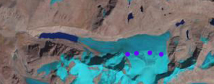
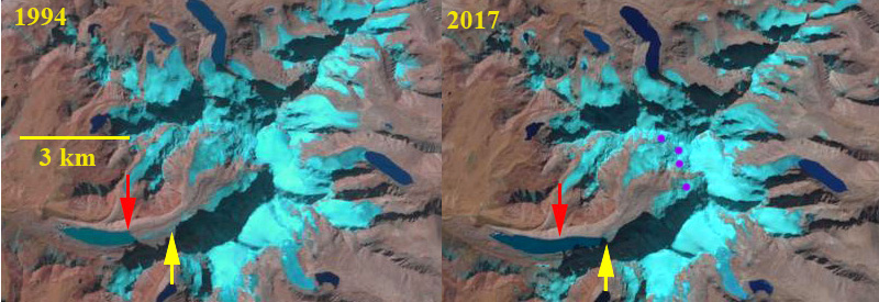
Tajuco Glacier terminating in Tajuco Lake retreat in 1994 and 2017 Landsat comparison. Red arrow is 1997 terminus location, yellow arrow is the 2017 terminus location and the purple dots are the snowline in 2017. 

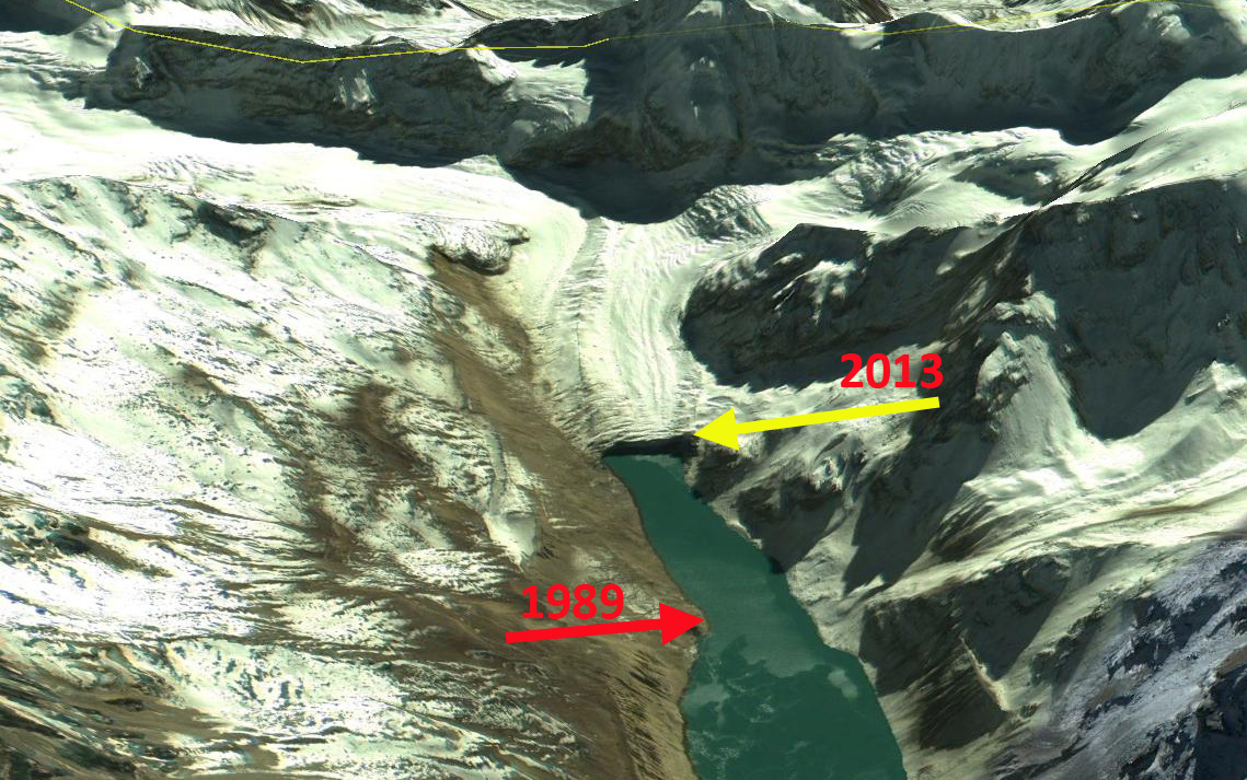
Tajuco Glacier Lake is a moraine dammed glacier lake in the Tingri district of China.  It drains into the Amur River which flows south into Nepal. Shijin et al (2015) reported on the expansion of the lake from 1990 to 2010 expanding from 0.65 square kilometers to 1.14 square kilometers.  They further reported that the Chinese Himalaya had 329 moraine dammed glacier lakes greater than 0.02 square kilometers in area, 116 of these posing a potential hazard, average size of 0.4 square kilometers. The number of lakes across the region is increasing (Kathmandu Post, 2017), though the number of GLOF’s has not.  The greater volume of expanding lakes puts more pressure on the moraine, the moraines if they have any ice core or permafrost can also weaken,  The moraines with time and distance from the glacier also can consolidate and become more stable.

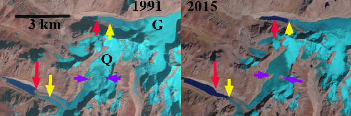
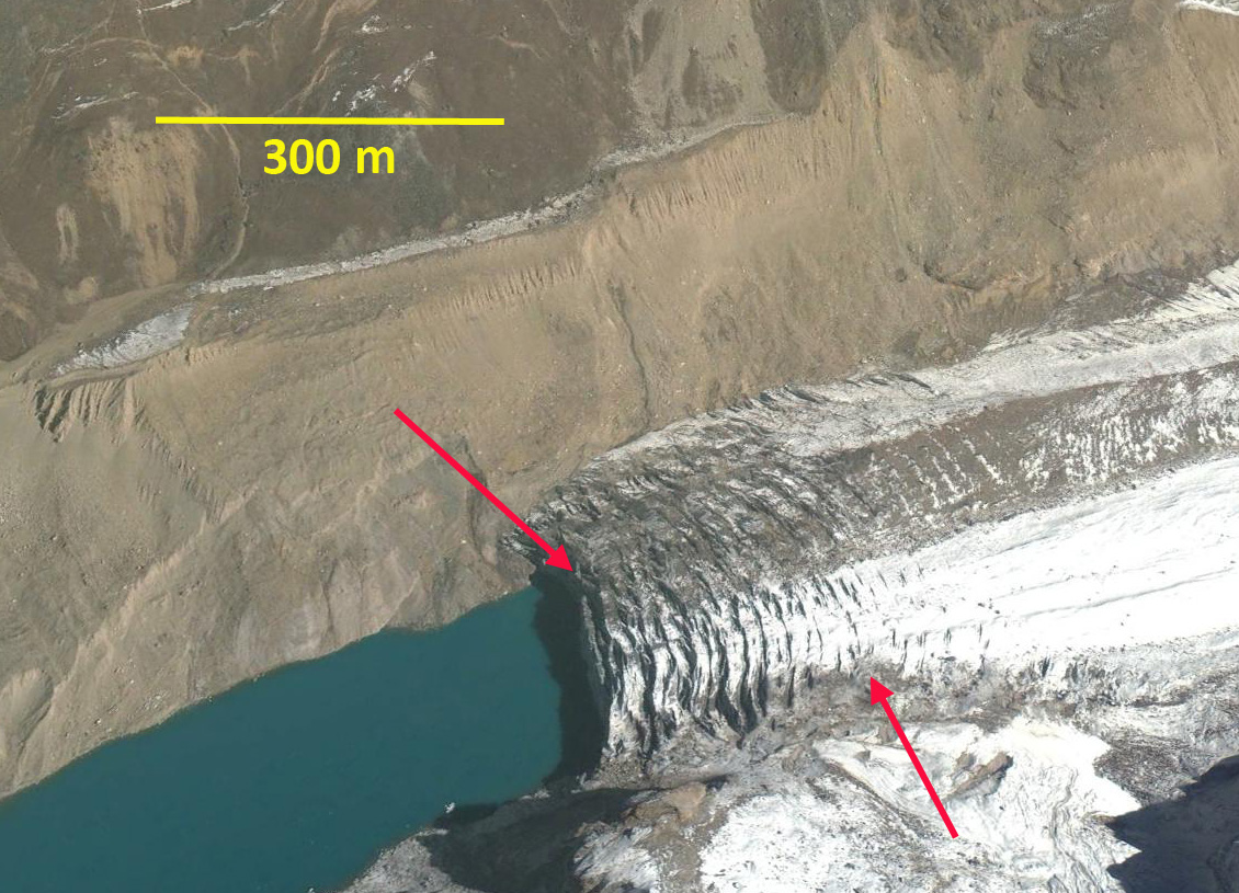
In 1994 Tajuco Lake was 1.85 km long and had an area of about 0.7 square kilometers.  The snowline was at 6400 m.  In 1997 glacier retreat had led to an expansion of the lake to 2.05 km.  By 2016 the glacier retreat had led to expansion of the lake to a length of 3 km.  The snowline is at 6500 m near the crest of the glacier.  By 2017 the glacier had retreated 1200 m from 1994 to 2017, a rate of 24 m/year. The snowline was again at 6500 m near the crest of the glacier.  The high snowline indicates a glacier that will not survive. retreat will continue to expand the lake.  It is likely based on the Google Earth imagery below that the lake will not increase by more than 500 m in length, area in 2017 is 1.20 square kilometers. The retreat and lake expansion is similar to that of other glaciers on the north side of the Himalaya Range in China; Chaxiqudong Glacier, Chutanjima Glacier and Yanong Glacier. The high snowlines have been observed on nearby Rongbuk Glacier at Nup La and on Gangotri Glacier.

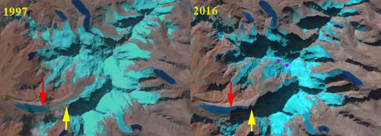
Tajuco Glacier terminating in Tajuco Lake retreat in 1997 and 2016 Landsat comparison. Red arrow is 1994 terminus location, yellow arrow is the 2017 terminus location and the purple dots are the snowline in 2016. 

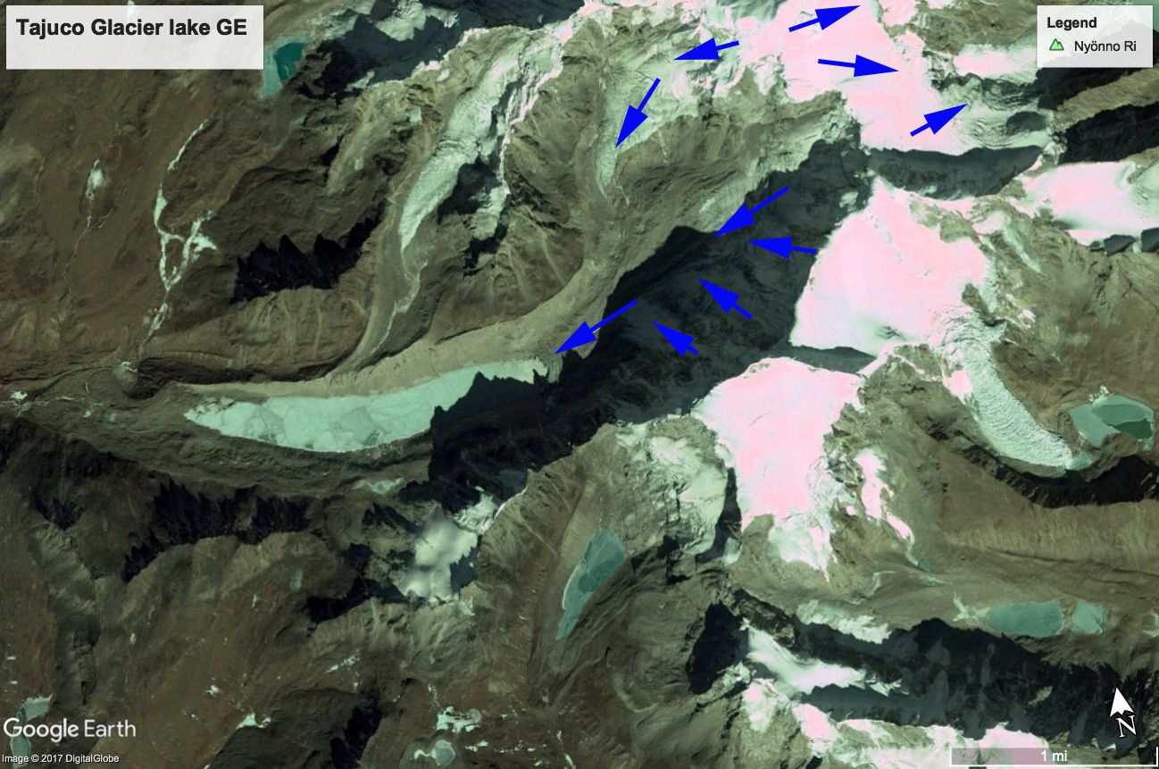
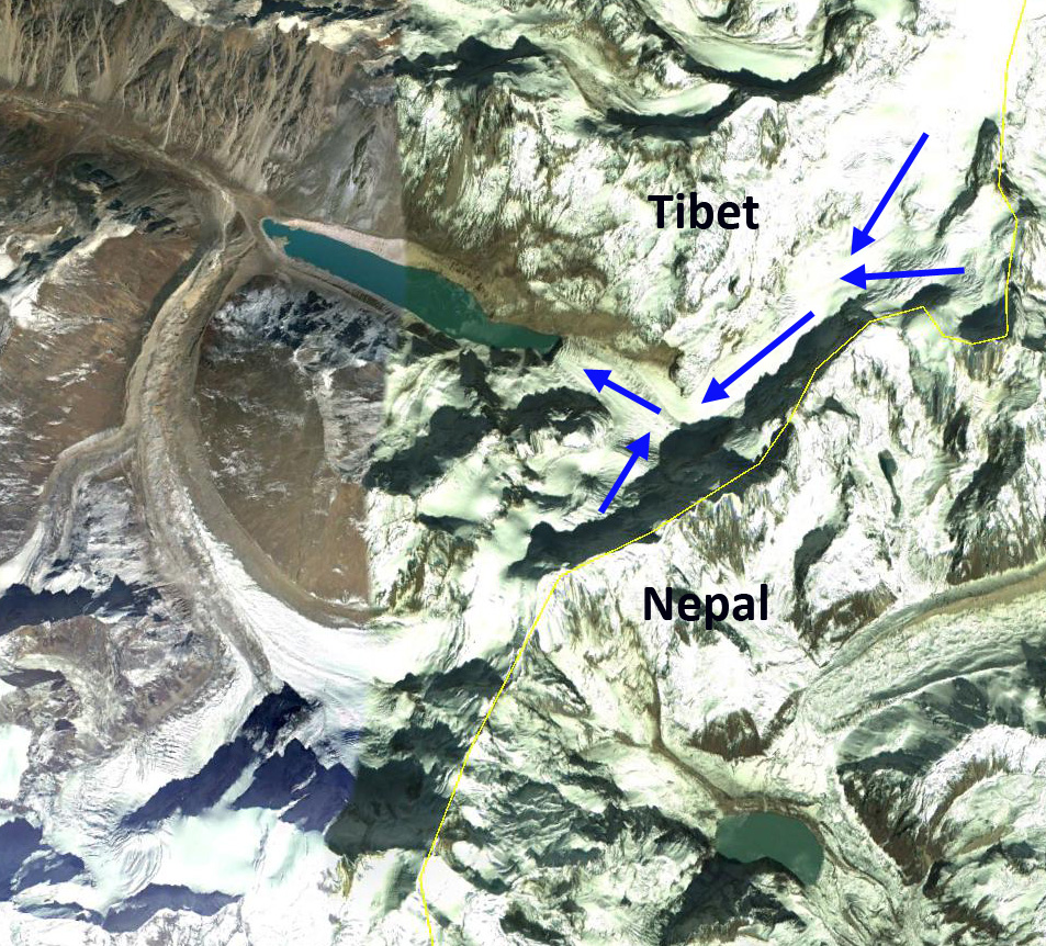
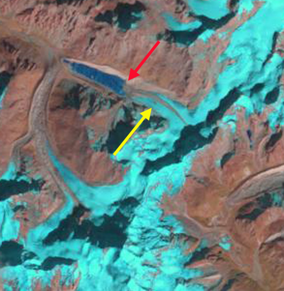
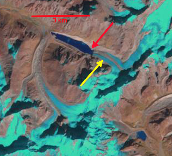
Google Earth image of Tajuco Glacier illustrating flow. 

Glacier Retreat expands Gelhaipuco Lake

gelhaipuco compare

Fig. H. Gelhaipuco Glacier (G) and Qangzonkco Glacier (Q) change from 1991 to 2015, red arrow indicates 1991 terminus, yellow arrow 2015 terminus and purple arrow indicates areas of thinning.

Gelhaipuco is a glacier moraine dammed lake at the headwaters of the Natangqu River in the Pumqu Basin, Tibet, China. In 1964 the lake had an outburst flood that resulted in severe damage and economic losses in the Chinese Tibet and downstream in the Arun valley in Nepal. The flood occurred after a heavy rainstorm with the rising lake overtopping and eroding the moraine dam significantly.  Today the water level is lower than the 1964 pre-flood water level. The glacier that ends in it is unnamed, but is referred to here as Gelhaipuco Glacier. Che et al (2014) reports that glaciers in the basin lost 19% of total area since the 1970’s and that the retreat rate increased in the 2001-2013 period.  The number of glacier lakes has increased from 199 to 254 since the 1970’s.  Of these 19 are deemed dangerous including Gelhaipuco (Che et al, 2014) . The lake has an estimated volume of ~25 million cubic meters and is a risk for a glacier outburst flood.The Arun River has a proposed 900 MW hydropower plant under development in Nepal.  In 1991 the glacier terminates at the red arrow in the lake, which was 750 m long. By 2015 glacier retreat had expanded the lake to 1500 m. The glacier retreat of 800 m is occurring in a lake that is maintaining consistent width.  The retreat is fueled by high snowlines such as in 2015, the snowline was at 5800 m, with no retained snowpack across the glacier divide to a separate terminus that flows east.  The terminus reach of the glacier has crevassing within 250 m calving front, indicating the role of iceberg calving.  The glacier lacks crevasses above this point for a kilometer, indicating the limited velocity to support the current level of melting and calving.  retreat will continue and the lake volume will continue to increase in the next decade.  The upvalley lake limit will likely be reached within the next kilometer of retreat.

gelhaipuco dam

Gelhaipuco lake and its unconsolidated moraine dammed lake.  Note the elevation listed near the former shoreline and the current outlet stream.

gelhaipuco 2015

Snowline on Gelhaipuco Glacier in 2015 at purple dots-5800 m.  Note there is no retained accumulation across the glacier divide from the east to west terminus.


Yejyumaro Glacier Retreat Lake Expansion, Tibet, China

An unnamed glacier draining the west side of Yejyumaro Peak a Nepal-China border peak, into Tibet is referred to here as Yejyumaro Glacier. The glacier is at the headwaters of the Arun River, which crosses into Nepal at Kimathanka. A 335 MW hydropower plant is being planned for the Upper Arun River fed by this and other glaciers. The glacier is adjacent to Nobuk Glacier across the border in Nepal.nobuk tibet overview
Google Earth images from 2002 and 2013 indicate both the glacier retreat and resulting lake expansion. Red arrow is the 1989 terminus position and yellow arrow 2013 terminus position. Notice the southern and northern arms joining and turning west. Both arms of the glacier are fed by the steep border peaks with considerable avalanching.
Nobuk tibet 2002
20002 Google Earth image
Nobuk tibet 2013
2013 Google Earth image

Landsat imagery from 1989 to 2013 is used to illustrate the response of this glacier to changing climate. In 1989 the glacier extended down the unnamed lake to a peninsula, with the lake being 2.3 km long. By 2000 the glacier had retreated from the peninsula, 150-200 m retreat since 1989. By October 2013 the glacier had retreated 700 m from the 1989 position into a narrower section of the lake. The lake is now 3 km long and still growing. A December 2013 image indicates how dry this region is during the early part of the winter with only a light snowcover across the glaciated areas and higher terrain. The last image is a the Google Earth closeup indicating the transverse crevasses that are above the terminus, the crevasses narrow moving up glacier away from the terminus and disappear 400 m above the terminus. These represent the acceleration near the calving front and the indicate that calving has helped accelerate glacier flow and glacier loss. This glaciers retreat is similar to so many in the area from Nepal such as the Nobuk Glacier that is adjacent to it in Nepal, and the many Tibetan glacier retreating along the the axis of expanding lakes, Reqiang, Matsang Tsanpo and Menlung Glacier.

yejyuamro 1989
1989 Landsat image

yejyumaro 2000
2000 Landsat image

yejyumaro 2013a
2013 landsat image

yejyumaro 2013
2013 Landsat image

yejyumaro terminus
Google Earth closeup