Coutts Ice Cap, Baffin Island Fragmentation

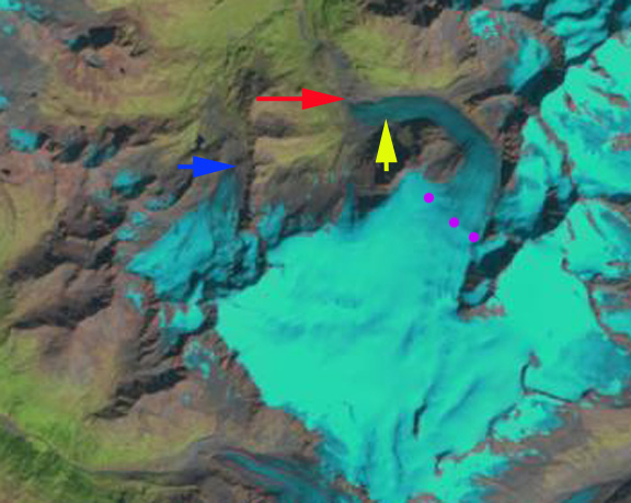
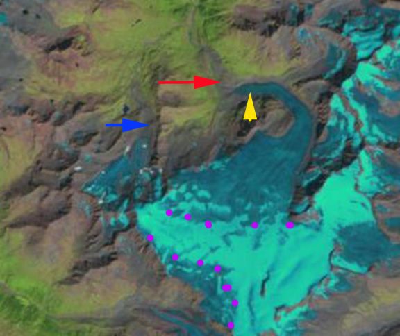
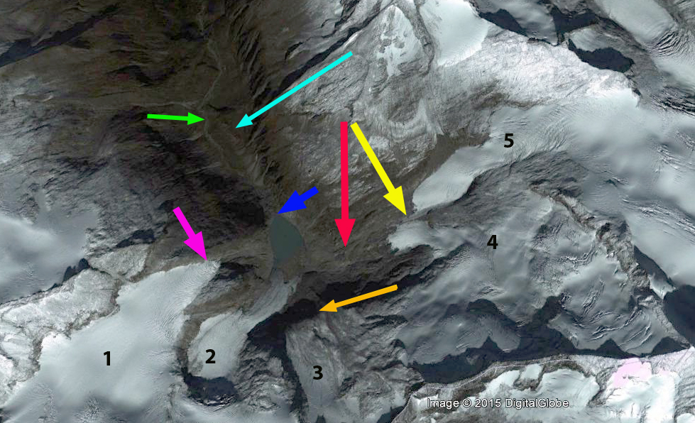
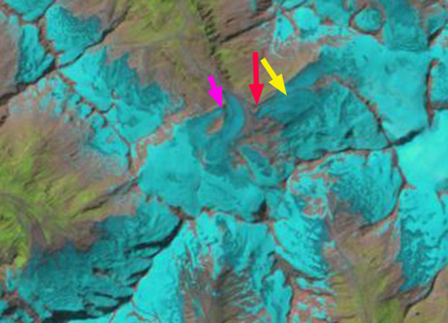
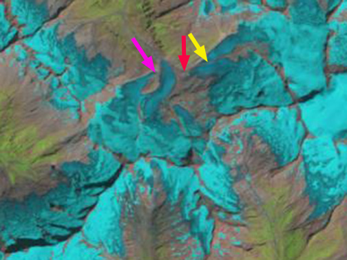
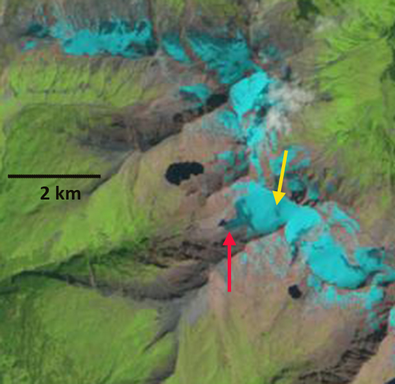
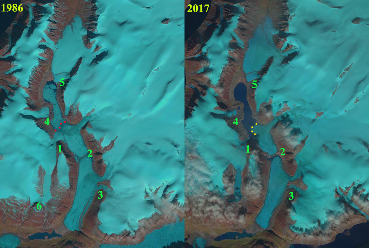
Coutts Ice Cap in  Landsat images from 1986 and 2017.  The terminus location of the main glacier terminating in the large lake is indicated by dots.  Tributary Glaciers 1-6 represent locations where glaciers have separated or a glacier has retreated from a lake. 

Coutts Ice Cap is on between Coutts Inlet to the west and Buchan Gulf to the east on the north shore of Baffin Island near its northeastern tip (see map below).  Here we are focused on a group of glacier that descend into a basin, that I refer to as Coutts Basin and Coutts Basin Lake. Gardner et al (2012) and Sharp et al (2011) both note that the first decade of the 21st century had the warmest temperatures of the last 50 years in the region, the period of record, and they identified that the mass loss had doubled in the last decade versus the previous four for Baffin Island. This led to surface lowering of up to 1 m/year on all ice masses on Baffin Island and Bylot Island between 1963 and 2006 (Gardner et al. 2012).

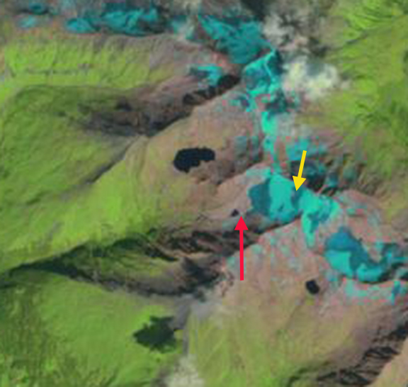
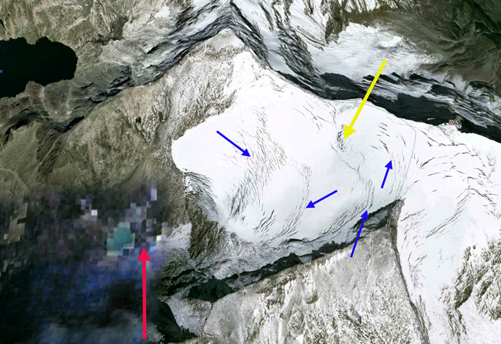
In 1986 the Tributary Glacier 1 (TG1), flows into the Coutts Lake basin joining with TG2.  TG3 feeds into the Coutts Basin glacier system.  TG4 has a significant piedomont lobe but terminates short of the Coutts Basin Lake. TG5 reaches the northern shore of Coutts Basin lake. TG6 drains into a secondary lake above the main Coutts Basin.  The main terminus of the Coutts Basin Glacier, red dots extends east to west across the lake. In 1999 the snowline is higher and there are minor changes, but retreat is limited and none of the glaciers have separated.  In 2016 the snowline is very high at 1500 m, leaving only a small part of the ice cap with snowcover. The high snowline in August 2016 have observed on Borden Ice Cap and Penny Ice Cap and have driven thinning and retreat there as well. TG1 no longer merges with TG2.  There is a separation of the glacier lobes at TG2.  TG3 no longer substantially feeds the Coutts Basin.  TG4 has thinned and retreated from near the short of Coutts Basin Lake. TG5 has receded from the lake shore.  TG6 has retreated from the upper lake. In 2017 the margin of the main Coutts Basin Glacier no longer extends across the lake, yellow dots. The snowline in August 2017 is at 1100 m lower than 2016.

Way (2015) noted that summer temperatures have warmed more than 1 C after 1990 on the Cumberland Peninsula at the south end of Baffin leading to a 18-22% decline of  Grinnell and Terra Nivea Ice Cap.

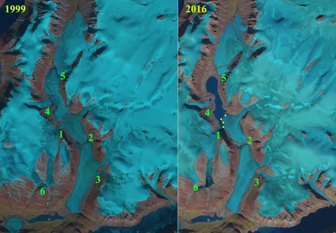
Coutts Ice Cap in  Landsat images from 1999 and 2016.  The terminus location of the main glacier terminating in the large lake is indicated by dots.  Locations 1-6 represent locations where glaciers have separated or a glacier has retreated from a lake. 

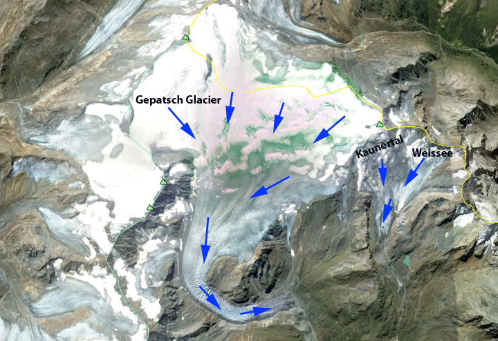
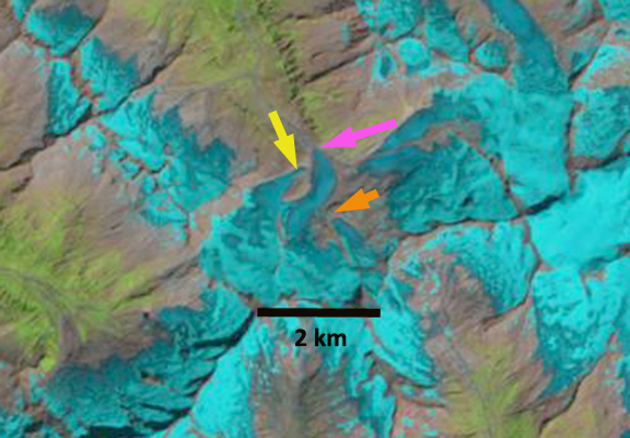
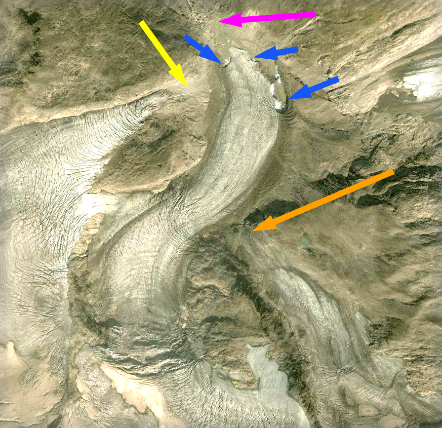
Map of the region indicating Cape Jameson (CJ), Coutts Inlet (CI), Buchan Gulf (BG), North Arm (NA), Coutts Basin Lake (CBL) and Coutts Ice Cap (CIC). 

Gepatsch Glacier Retreat, Austria 1984-2013

Gepatsch Glacier (Gletscher), Austria the runoff from this glacier drains into the Gespatsch Reservoir, which has a storage volume of 140 million cubic metres of water and an annual electricity production of 620 million kwh. The glacier is Austria’s second largest with an area of over 16 square kilometers. The adjacent Weißsee-Kaunertal Gletscher is host to Kaunertal Gletscher ski area and in the summer a key destination of the Gletscherpark.  The ski area map below indicates several lifts on the Weißsee-Kaunertal Gletscher. This glaciers retreat will reduce summer water supply to the reservoir, as it provides 50 million cubic meters of runoff each summer. With climate change that runoff will no longer peak in the warmest-driest part of the summer. The retreat is similar to that of Obersulzbachkees, Austria the third largest in Austria.

kaunertaler-gletscher_trail_map_l3 (1)
Ski Area Map

gepatch 2007

2007 Google Earth image

In 1985 the glacier terminated at the red arrow, expanding across the bottom of the valley where it turns south. The Weißsee-Kaunertal Gletscher terminus is at the blue arrow and the snowline is just above the icefall at the purple dots.  In 1990 there is little evident change, the snowline is higher above the icefall, the glacier in fact ended a decade of advance in 1988. By 2000 Gespatch Gletscher has retreated 200-300 meters from the red arrow. Weißsee-Kaunteral Gletscher has retreated 100-150 m from the blue arrow.  In 2010 most of the glacier has lost its snowcover, which was frequently the case from 2000-2010.  The terminus has retreated up the westward oriented side valley several hundred meters.  There is essentially no snow on the Weißsee-Kaunertal Gletscher.   By 2013 Gepatsch Gletscher has retreated 800-900m from its 1985 position, with most of the retreat since 1990. Much of this retreat occurred from 2010-2013 of 240 m of retreat and another 120 m in 2014, 52 meters per year, as noted in the annual reports of the Austrian Alpine Club glacier report completed by Andrea Fischer each year (Fischer, 2015).

It is evident in the 2003 Google Earth image that rapid retreat was imminent as the terminus of the galcier was stagnant. The Weißsee-Kaunertal Gletscher has retreated 300 m and has thinned even more from 1990-2013.  The   Alpine club also observes this glacier and notes typical retreat rates in the last five years ranging from 15-25 meters/year.   Given the ski lifts emplaced on this glacier, continued thinning and retreat will increasingly impact ski area operation.  The ski area has not resorted to artificial means to sustain Weißsee-Kaunertal Gletscher as has been done at nearby Pitzal Glacier ski area.

gespatch 1985
1985 Landsat Image

gespatch 1990
1990 Landsat Image

gespatch 2000
2000 Landsat Image

gespatch 2010
2010 Landsat Image

gespatch 2013
2013 Landsat Image

gepatch terminus 2003
2003 Google Earth Image
weissee lifts
Google Earth Images ski lifts evident as the linear feature on the nearly snowless galcier. 

Weisee 2003

Disaggregation of Austria’s Third Largest Glacier, Obersulzbach Kees

The Obersulzbach Glacier, is situated in the uppermost part of the Obersulzbach Valley, which feeds the Salzach River system in Austria. The glacier drains the northeastern flank of Großvenediger. The glacier was the third largest glacier in Austria in the 1980’s, but in the last several decades separated into five distinct sections. Now that it is in five parts, should it be listed as such?

Yes, given that the Austrian Glacier Inventory has reclassified the glacier as five separate glaciers (Fischer et al, 2014). In this post they are numbered 1=Krimmlertorl Kees, 2=Obersulzbach Kees, 3=Bleidacher Kees, 4=Sulzbacher Kees, 5=Venediger Kees.

Nick Fisher sent me a map of the glacier prepared by the Austrian Military in the early 1930’s this is compared to the GE image of the glacier from 2012, below. According to this map, in 1934 the ice was at least 150 m deep over the current lake surface, where all the glacier streams united before heading down the ice fall. In 1934 the five branches of the Obersulzbach all joined and continued downglacier past a prominent rib on the east side of the glacier, light blue arrow, to terminate at 1980 meters, green arrow. The two western most glaciers Krimmerlertorl and Obersulzbach on the images, were joined at the pink arrow in 1934 and are well separated in 2012.  At the orange arrow in 1934 Bleidacher (3) flowed over a steep cliff and joined the other segments.  Today the glacier section ends at the top of a steep cliff.  Glacier Sulzbacher and Venediger are the largest and easternmost draining the actual slopes of Großvenediger.  They joined the other segments in 1934. By 1988 they had retreated to the red arrow but the two were still joined, by 2012 they had separated at the yellow arrow.  Hence, we now have separate glaciers that formerly joined together. The World Glacier Monitoring Service reports indicate this glacier retreated 140 meters from 1991-2000 and 345 m from 2001-2010, a substantial increase. Here we examine Landsat imagery from 1988, 1998, 2012, 2013 and 2014 to identify the retreat andand separation of the glacier into.  By 1998 a small lake less than 100 m long has formed at the end of the glacier, blue arrow.

obersulzbachkees map
Map of the Obersulzbach Region in 1934 from Nick Fisher
obersulzbach ge 2012
Google Earth image from 2012

In 1988 there is no lake visible at the end of the main terminus. The glacier has retreated 1.4 km since 1934. At the pink arrow glacier Krimmerlertorl and Obersulzbach are still joined in 1988. Glacier Sulzbacher and Venediger are also still joined at the yellow arrow and terminate at the red arrow. Glacier section Bleidacher has become detached.

By 1998 Krimmerlertorl and Obersulzbach are separated but the eastern glaciers Sulzbacher and Venediger are still joined at the yellow arrow. No lake yet exists at the terminus. Obersulzbach Glacier receded in a narrow bedrock basin since the late 1990’s and a shallow lake, Obersulzbach-Gletschersee, has formed since 1998 (Geilhausen et al, 2012). They observed that in 2009, the lake had an area of 95,000 m2 with a maximum depth of 42 m.

By 2013 all the glacier segments are separate. By 2013 the lake, Obersulzbach-Gletschersee,has grown to a length of 450 m and a with of over 200 meters. The retreat from 1988-2013 of glaciers Krimmerlertorl=0.8 km, Obersulzbach=0.6 km, Bleidacher=1.3 km, Sulzbacher=1.4 km, Venediger=1.6 km. The 2014 image is not as clear, but further retreat did occur.  The Austrian Alpine Club 124th annual survey indicated 86% of Austrian glaciers retreated from 2013-2014.

The Salzach is fed by many glaciers covering over 100 square kilometers (Koboltschnig and Schoner, 2011). These glaciers melt all summer providing considerable runoff to the numerous hydropower projects along the Salzach, that can produce 260 MW of power. The Verbund Power Plant producing 13 MW is seen below, at blue arrow. Glacier area loss will lead to declines in summer runoff.  A mass balance program has been started on Venediger Kees.

This glaciers retreat fits the pattern of other glaciers in the Austrian Alps, Oberaar Glacier, Rotmoosferner and Ochsentaler.

obersulzbachkees 1988
1988 Landsat image
obersulzbachkees 1998
1998 Landsat image
obersulzbachkees 2013
2013 Landsat image
obersulzbachkees 2014
2014 Landsat image
salzbach hydro


Verbund Power Station, blue arrow.

Kleinfleisskees Retreat, Austria

Kleinfleisskees is a small glacier in the Hohe Tauern region in the eastern Austrian Alps. The glacier had an area of 0.87 km2 in 2004 (Binder, 2006). The glacier is located adjacent to the Sonnblick Observatory (3106m), which has both a long term climate record and a webcam.The mass balance of this glacier has been assessed since 1999 (Hynek et al, 2011). From 1999-2012 the glacier has lost 7 m of water equivalent, which is over 8 m of glacier thickness. (WGMS). Unger et al. (2012) produced a map of the changes in this and other nearby glaciers from 1850 to 2009 that was published by WGMS. Here we examine changes in the glacier from 1990 to 2013 using Landsat and Google Earth imagery.

Kleinfleiss change map
Unger et al (2012) Map of glacier change.

In each image the red arrow indicates the 1990 terminus and the yellow arrow an outcrop of rock that emerges after 1990. In 1990 the glacier extends to a small lake, red arrow. This terminus tongue is 200 meters wide and 300 meters long. At the yellow arrow the annual snowcover has been lost and glacier ice is exposed. In 2001 the terminus tongue has nearly disappeared and the glacier no longer reaches the lake. The yellow arrow again indicates a location where snowcover has been lost and a large area of glacier ice exposed, with the hint of bedrock emerging. By 2013 the glacier terminus tongue is gone, the glacier has retreated 400 m from the 1990 position, with most of the retreat occurring by 2005. An area of bedrock has emerged at the yellow arrow as the glacier ice covering of this location has been lost. Retreat from 2006-2013 was minor according to the WGMS and the Austrian Alpine Club Inventory. In 2012 this survey found 94 glaciers in retreat and 2 stationary out of 96. In 2012 and 2014 glacier mass balances have been quite negative on the glacier, which will fuel more retreat. The glacier lost nearly its entire snowpack in 2014 as seen from the webcam at Sonnblick Observatorium on August 9th. Fortunately several late summer snowstorms prevented high ablation after this date. This glacier does continue to have significant crevassing indicating a good flux towards the terminus in the Google Earth image of 2006. The glaciers retreat is similar to that of Hochalm, Oschentaler and Rotmoosferner.
kleinfleisskees 1990
1990 Landsat image
kleinfleisskees 2001
2001 Landsat image
kleinfleisskees 2013
2013 Landsat image
sonnblikes obs
Sonnblick Observatorium image from 8/9/2014
KleinFliess Glacier ge
Google Earth image from 2006.

Obersulzbach Glacier Retreat, Austria

The Obersulzbach Glacier, is situated in the uppermost part of the Obersulzbach Valley, which feeds the Salzach River system in Austria. The Salzach is fed by many glaciers covering over 100 square kilometers (Koboltschnig and Schoner, 2011). These glaciers melt all summer providing considerable runoff to the numerous hydropower projects along the Salzach, that can produce 260 MW of power. The Verbund Power Plant producing 13 MW is seen below, at blue arrow.salzbach hydro The glacier has receded in a narrow bedrock basin since the late 1990’s and a shallow lake, Obersulzbach-Gletschersee, has formed since 1998 (Geilhausen et al, 2012). (Geilhausen et al, 2012) observed that in 2009, the lake had an area of 95,000 m2 with a maximum depth of 42 m. Nick Fisher sent me a map of the glacier prepared by the Austiran Military in the early 1930’s this is compared to the GE image of the glacier from 2000, below. The green arrow indicates the 1930’s terminus extending due east from the nose of a ridge and the blue arrow parallels a prominent ridge somewhat above the terminus. The pink arrow in these images and in the Landsat images further below indicates the 1988 terminus position, the yellow arrow the mid section of a glacier tongue from the west that rejoined the main terminus in 1988, the orange arrow the top of a cliff where the eastern tributary ended in 1988. As Nick has noted: Since 1934,the glacier has retreated about 1.6 km,from a terminus at 1980 m, and the proglacial lake lies just behind where once was a magnificent ice fall known as the Turkische Zeltstadt (Turkish Tent City). The Zeltstadt is now a series of waterfalls. According to my map, in 1934 the ice was at least 150 m deep over the current lake surface,where all the glacier streams united before heading down the ice fall. obersuzlbach glacier ge

obersulzbachkees map The World Glacier Monitoring Service reports indicate the glacier retreated 140 meters from 1991-2000 and 345 m from 2001-2010. Here we examine Landsat imagery from 1988, 1998, 2011 and 2012 to identify the retreat of this glacier and formation of the new lake. The pink arrow in each image indicates the 1988 terminus position, the yellow arrow the mid section of a glacier tongue from the west that rejoined the main terminus in 1988, and the orange arrow the top of a cliff where the eastern tributary ended in 1988. By 1998 a small lake less than 100 m long has formed at the end of the glacier. By 2011 and 2012 the lake has grown to a length of 450 m and a with of over 200 meters. The main terminus has retreated 450 to 500 m in the last 25 years. The western tongue at the yellow arrow no longer connects to the main terminus in 1998. By 2011 and 2012 the western tongue is separated by 600 meters from the main terminus. The eastern tongue has retreated 400 m from the cliff by 2012. sulzbach 1988

sulzbach 1998

sulzbach 2011

sulzbach 2012
A closeup view of the terminus in 2003 from Google Earth indicates the lake development in three small locations around the terminus at the blue arrows. This glaciers retreat fits the pattern of other glaciers in the Austrian Alps, Oberaar Glacier, Rotmoosferner and Ochsentaler. obersulzbach ge

Hallstatter Glacier, Austria retreat

The Hallstatter Glacier (also sometimes called Dachstein Glacier along with the Gosau Glacier) is on the north slope of Dachstein an area of heavy recreational use. The result is good photographic records of glaciers change. This record combined with a recent cooperative project between University of Innsbruck, Blue Sky Weather Analysis and Energie AG Upper Austria provides a good snapshot of glacier change in northern Austria. The glacier begins at 2800 meters and descends to 2200 meters, image below from University of Innsbruck. This project has compiled the annual terminus change of the glacier from 1950-2007, in the image below. The retreat from 1950-1975 averaged 8 meters per year. A period of minor readvance from 1977-1991 occurred, followed by increasingly rapid retreat from 1992-2007 averaging over 10 meters per year in the last decade. Total retreat has been 350 meters from 1950-2007. Over the last century the change is chronicled in the two images, 1900 and 2007, from the Dachstein Project and the 2009 margin is traced in a Google Earth Image, blue line. This project was undertaken because of the importance of the glacier runoff to hydropower production along the Traun and Gosau Watersheds in particular. The change in terminus via mapping from 1969-2002 is evident in the Innsbruck image (2002), the Google Earth image is from 2009. There is thinning particularly of the width of the two main terminus tongues.The mass balance of the glacier has been measured since 2007, every year has had negative balances. In 2011 the snowline was again high, snowpack very limited at the end of the melt season which persisted into October. An Ikonos image from October 2, 2011 indicates that 30-35 percent of the glacier is snowcovered, this is the AAR and it needs to be at 60 for equilibrium.

Ochsentaler, Austria Rapid Glacier Retreat

Ochsentaler is a glacier in the Silvretta group of southwest Austria. From 1990 to 1995 the glacier retreated 75 meters, from 1995-2000 85 meters, and from 2000-2005 180 m. The accelerating retreat has been driven by substantial negative mass balances. Dyugerov and others (2009) assessed the mass balance of the glacier as averaging -0.5 meters per year lost, from the percentage of snowcovered area remaining at the end of the summer. Measurements on the neighboring Jamtalferner in Austria indicate 15 m of loss from 1990-2009, about 0.75 meters per year. Mass balance losses on Silvretta Glacier, Switzerland indicate a 13 m loss during that same period. Examination of the glacier today indicates an uncrevassed, thin stagnant glacier tongue that is 600 meters long, that is and should continue to rapidly melt. At the head of this section of the glacier is an icefall. The newly exposed bedrock areas at the crest of the icefall indicate reduced iceflow and thinning at this point. The contrast in this icefall region is apparent in the image pair from Christian D. from 1995 and 2011 and the latter image 2009 in Google Earth.
. Ochsnetaler is a popular climb and the upper section of the glacier above the icefall still has a considerable snow covered extent. This glacier is certainly healthier than Stubai Glacieror Presena Glacier and similar to Rotmoosferner.