Brady Glacier Retreat Causes Ice Dammed Spur and Trick Lake Drawdown

Brady Glacier terminus region in September 28, 2022 Sentinel image. Red dots indicate the 2016 margin. Point A marks the new isthmus exposed by falling lake water level. Point B-D are the expanded drainage channels.

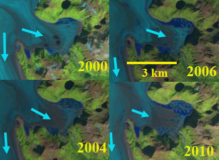
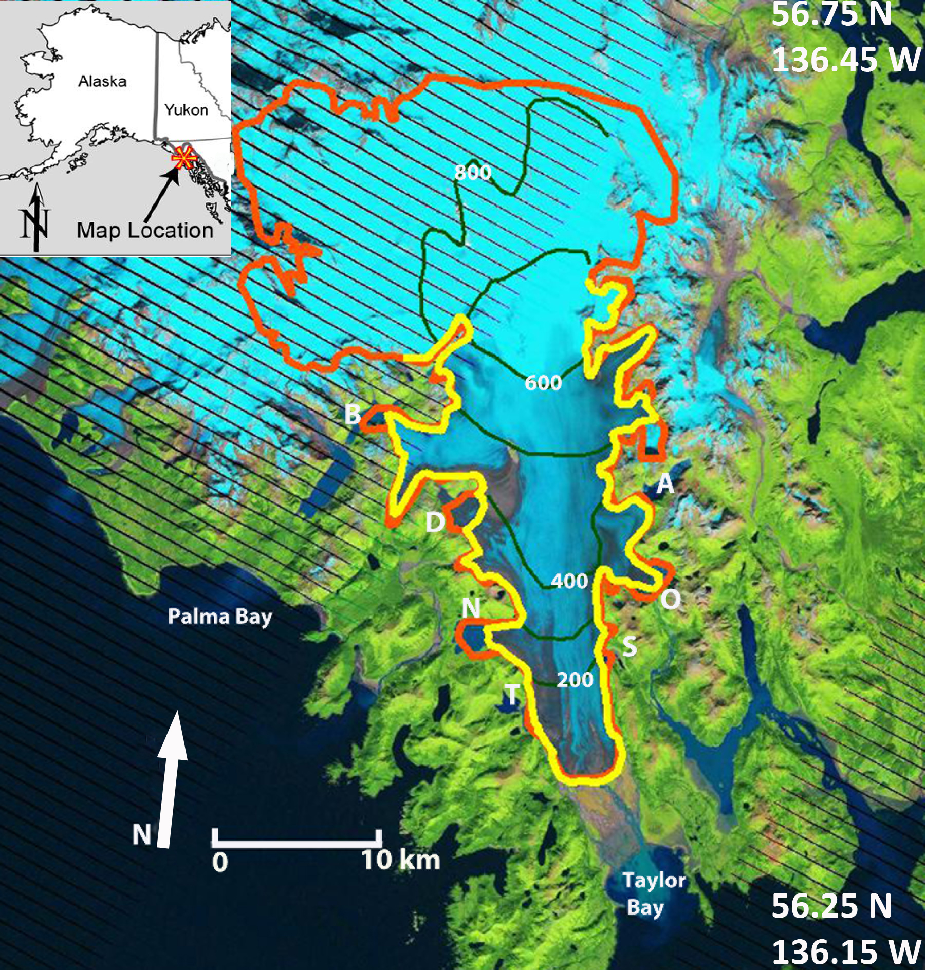
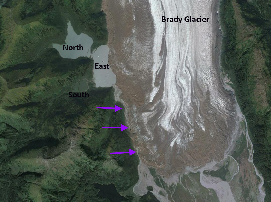
Brady Glacier is a large Alaskan tidewater glacier in the Glacier Bay region that is beginning phase of substantial retreat that was forecast by Pelto et al (2013). The glacier has seven secondary termini in marginal ice dammed proglacial lakes. There was a consistent pattern in the change in position of the glacier margin at each of the lakes between 1948 and 2010. The rate of retreat of the glacier margin at all seven ice dammed lakes accelerated later during this period; the mean retreat rate was 13 m/a from 1948 to 2004 and 42 m/a from 2004 to 2010 (Pelto et al 2013). Lake area and calving fronts were measured for each lake: Spur, Abyss, North Deception, Bearhole, Oscar, and East Trick based on the September 2010 imagery, with earlier measurements from Capps  et al (2010). Lake areas can increase as a result of Brady Glacier marginal retreat, and can decrease due to declines in surface water levels as previously ice-dammed conduits form to drain the lake (Pelto 2016). Here we examine the changes in area of  Spur and Trick Lake from 2016-2022 during development of substantial marginal drainage channels. During this period the terminus of the glacier has retreated on average 175 m, with 300 m of retreat from its maximum position advance position.

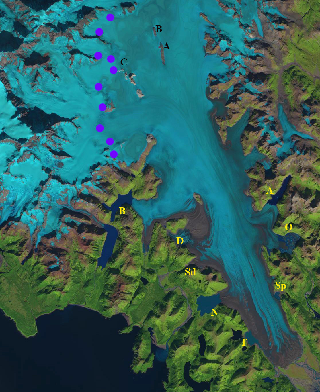
Brady Glacier terminus region in September 29 2016 Sentinel image. Yellow dots indicate the 2022 margin. East and North Trick lakes are connected basins. Spur Lake still has an eastward extension.

Trick Lakes: In 1986 North and South Trick Lake were proglacial lakes in contact with the glacier. By 2016 the two lakes were no longer in contact with the glacier, water levels had fallen and a third lake East Trick Lake had formed. North Trick Lake  and South Trick Lake are currently relatively stable moraine-dammed lakes. The more recently developed East Trick Lake is the current proglacial Trick Lake, a large glacier river exits this lake and parallels the glacier to the main Brady Glacier terminus. In 2016 this river was narrow and flowed beneath the glacier in several spots.  By 2022 the channel has expanded to a width that seldom is less than 200 m, and is tranisitioning to an ice marginal lake. East Trick Lake has an area of 1.25 km²  in 2016, expanding to 1.4 km² in 2019, before declining to 1.0 km² in 2022 with the lake separating into two parts by a narrow peninsula exposed by falling water levels. The water level decline resulting from a  200 m marginal retreat from 2016 to 2022 has led to a narrow isthmus running across the lake from the glacier to be exposed. At Point E below the trimlines from reduced water levels are evident.

Spur Lake: It is likely that retreat toward the main valley of the Brady Glacier will lead to increased water depths at Spur Lake. a marginal retreat of 600 m led to a lowering lake water level from 2010-2016. The lake had an area of 0.6 km2 in 2010, 0.5 km² in 2016, o.5 km² and 0.5 km² in 2022. The lake area decline due to falling water level has been matched by lake area increase due to marginal retreat of Brady Glacier. This marginal retreat has also opened a marginal channel along the east edge of the glacier, draining Spur Lake. This drainage has led the lake shoreline to migrate west. Marginal retreat has been ~100 m from 2016-2022. The marginal river on the east side of the glacier was narrow and occasionally went beneath the glacier in 2016. In 2022 the channel has expanded so that the upper 2.5 km and lower 1.5 km is more of a marginal lake.

North Deception Lake has been expanding as the glacier has retreated 600 m, 100m/year from 2016-2022 while maintaining its water level. At present there is not a marginal channel developed that can reduce the water level. How long until a channel opens?

In Alaska the glacial lakes have expanded in area by 58% from 1984-2018 (Field et al 2021), however the ice dammed lakes declined by 0.4%. The latter indicates the competing impacts of water level reduction due to glacier recession of ice dammed lakes, and the expansion due to retreat as well.

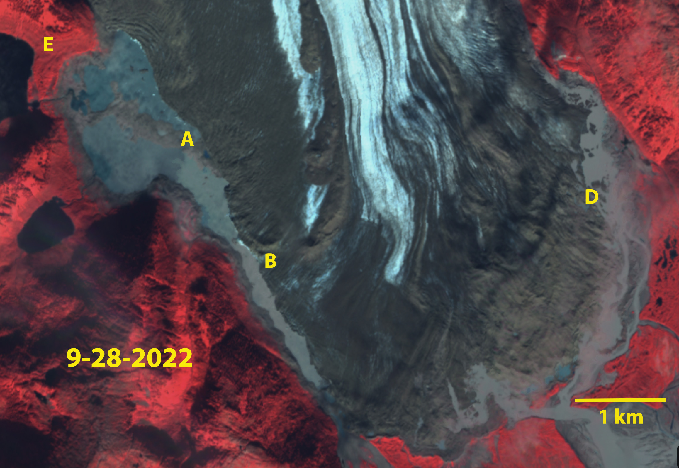
Brady Glacier terminus region in September 28, 2022 Sentinel image. Point A marks the new isthmus exposed by falling lake water level. Point B and D are the expanded drainage channels. Point E is where trimlines are evident.

Oscar Lake Expansion Carves Away at Brady Glacier, Alaska

Oscar Lake growth on the east margin of Brady Glacier in Landsat images from 2000-2020. Point A indicates glacier tongue that becomes iceberg. Blue arrows indicate flow direction.

Brady Glacier,  is a large Alaskan tidewater glacier, in the Glacier Bay region that is beginning a period of substantial retreat Pelto et al (2013).   The glacier has a number of expanding lakes that are expanding as the secondary termini feeding them retreat. The lakes Trick, North Deception, Dixon, Bearhole, Spur, Oscar, and Abyss continue to evolve. Pelto et al (2013) noted that the end of season observed transient snowline averaged 725 m from 2003-2011, well above the 600 m that represents the equilibrium snowline elevation.In 2018 and 2019 the melt season has been intense for the Brady Glacier in Alaska reaching 1100-1200 m both years. Here we examine the expansion of Oscar Lake from 2000-2020.

In 2000 the lake was just developing and had an area of ~0.5 km2.  In 2004 the lake had expanded to ~0.8 km2.  In 2006 the glacier was 1.0 km2 in area, Capps et al (2010) reported the maximum lake depth measured with a remote control boat at 140 m near the ice front.  The glacier still reaches the east margin of the basin separating the lake into a northern and southern section. They further noted that nearby Abyss Lake had begun to drain subglacially into Oscar Lake. In 2010 Oscar Lake had doubled since 2006 to an area of 2 km2.  In 2004 the glacier tongue that extends to the east margin of the lake is still in place, but is too narrow to be stable. In 2016, 2018 and 2019 very high snowlines led to extensive melt and glacier thinning, reported in 2016 (Pelto, 2016), and on nearby Taku Glacier setting a record (Pelto, 2019).  In 2018 and 2019 a debris covered tongue, Point A, remained attached to the main glacier.  In July 2020 this tongue has broken free.  The lake now has an area of 4 km2.  The high snowline in 2019 exposed many firn layers from previous years.  These layers were the retained snowcovered from previous winters, that had survived summer and been buried by the next years snowfall.  The collective melt of the recent years is exposing the layers.

Oscar Lake growth on the east margin of Brady Glacier in Landsat images from 2000-2010 Blue arrows indicate flow direction. There is a southern and northern part of the lake separated by the glacier tongue during this period.

Oscar Lake in 2014 in a Digital Globe image. Note unstable tongue exteding to east end of basin.

Brady Glacier in 98/2019 Landsat image indicating snowline at 1100-1200 m with purple dots. S=Spur Lake, O=Oscar Lake, A=Abyss Lake,  F=Firn lines, D=Dixon Lake, B=Bearhole Lake, N=North Deception Lake, T=Trick Lake


Firn layers on upper Brady Glacier in 9/8/2019 Landsat image.


Brady Glacier, Alaska Nunatak Expansion and High Snowline 2018

Emergence of Nunataks at Point A, B and C at 850 m on Brady Glacier from 1986 and 2018 Landsat Images.  Transient snowline on 9/21/2018 indicated by purple dots.

Brady Glacier,  is a large Alaskan tidewater glacier, in the Glacier Bay region that is beginning a period of substantial retreat Pelto et al (2013). Pelto et al (2013) noted that the end of season observed transient snowline averaged 725 m from 2003-2011, well above the 600 m that represents the equilibrium snowline elevation, for the glacier to sustain its current size. In 2015, 2016 and 2018 the snowline has been at 900-1000 m.  This is leading to thinning across of what was much of the accumulation zone.  Here we examine Landsat images from 1986 to 2018 to identify signs of this thinning.

In 1986 Point A and B have insignificant rock exposure, while C has a limited single rock nunatak.  By 2000, below there is bedrock exposed west of Point A and B, with two small nunataks near C.  By 2015 there is a 2 km long bedrock ridge at Point A and a ~1 km long bedrock ridge at Point B.  The snowline in 2015 is just above Point B and C at 900 m.  In 2016 on Oct. 1 2016 after the end of the typical melt season the snowline is at 900 m. In 2018 the snowline on Sept. 21 is at 1000 m.  At Point A the bedrock Ridge is now 2300 m long and up to 300 m wide.  At Point A the ridge is 1100 m long.  At Point C a third nunatak has emerged and the series of nunataks will soon merge into a single ridge.

The persistent high snowlines indicate the consistent accumulation zone is now above 900 m, below this point thinning will continue.  The mean elevation of the glacier is at 720 m and thinning is significant below 1000 m from 1995-2011(Johnson et al 2013).  That far less than 50% of the glacier is retaining snowpack and widespread thinning will drive further retreat of the distributary glacier termini in expanding lakes noted by Pelto et al (2013) and a the 2016 blog post.   Brady Glacier abuts the adjacent Lampugh Glacier that has and will be impacted by a large landslide.

Trick Lakes: In 1986 North and South Trick Lake are proglacial lakes in contact with the glacier. By 2016 the two lakes are no longer in contact with the glacier, water levels have fallen and a third lake East Trick Lake has formed. The more recently developed East Trick Lake is the current proglacial Trick Lake, a large glacier river exits this lake and parallels the glacier to the main Brady Glacier terminus, going beneath the glacier for only several hundred meters.

North Deception Lake had a limited area in 1986 with no location more than 500 m long. By 2016 retreat has expanded the lake to a length over 2 km. The width of the glacier margin at North Deception Lake will not change in the short term, but the valley widens 2 km back from the current calving front, thus the lake may grow considerably in the future.

South Dixon Lake This new lake does not have an official name. It did not exist in 1986, 2004, 2007 or 2010. It is nearly circular today and 400 m in diameter.

Dixon Lake: It is likely that retreat toward the main valley of the Brady Glacier will lead to increased water depths at Dixon Lake, observations of depth of this lake do not exist. Retreat from 1986 to 2016 has been 600 m.

Bearhole LakeBearhole Lake is expanding up valley with glacier retreat, and there are no significant changes in the width of the valley that would suggest a significant increase in calving width could occur in the near future. Currently the lake is 75 m deep at the calving front and there has been a 1400 m retreat since 1986 Capps et. al. (2013).

Spur Lake:It is likely that retreat toward the main valley of the Brady Glacier will lead to increased water depths at Spur Lake. the depth has fallen as the surface level fell from 1986-2016 as the margin retreated 600 m, leaving a trimline evident in the 2016 imagery.

Oscar Lake has experienced rapid growth with the collapse of the terminus tongue. Depth measurements indicate much of the calving front which has increased by an order of magnitude since 1986 is over 100 m. The tongue as seen in 2014 Google Earth image will continue to collapse and water depth should increase as well. The central narrow tongue has retreated less than 200 m since 1986, but the majority of the glacier front has retreated more than 1 km since 1986.

Abyss Lake: Continued retreat will lead to calving width expansion> The retreat from 1986 to 2016 has been 400 m. The water depth has been above 150 m at the calving front for sometime and should remain high.

Emergence of Nunataks at Point A, B and C at 850 m on Brady Glacier from 2000 and 2015 Landsat Images.  Transient snowline on 9/21/2018 indicated by purple dots.

Landsat image of Brady Glacier on 9/21/2018 indicating the snowline (purple dots)  and the emerging nunataks at Point A-C. Lakes noted are: A=Abyss, B=Bearhole, D=Dixon, N=North Deception, O=Oscar, Sd=South Dixon, Sp=Spur, T=Trick.

Landsat image of Brady Glacier on 10/1/2016 indicating the snowline (purple dots)  and the emerging nunataks at Point A-C.

Brady Glacier, Alaska 2016 Early Melt Season & Lake Expansion

brady lake compare 2016

Comparison of Brady Glacier in 1986 and 2016 Landsat images.  The snowline is similar in May 2016 and August 1986. Lakes noted are: A=Abyss, B=Bearhole, D=Dixon, N=North Deception, O=Oscar, Sd=South Dixon, Sp=Spur, T=Trick.

Brady Glacier,  is a large Alaskan tidewater glacier, in the Glacier Bay region that is beginning a period of substantial retreat Pelto et al (2013). In 2016 the melt season has been intense for the Brady Glacier in Alaska. Pelto et al (2013) noted that the end of season observed transient snowline averaged 725 m from 2003-2011, well above the 600 m that represents the equilibrium snowline elevation. On May 20, 2016 the transient snowline (TSL) is at 500 m. Typically the TSL reaches 500 m in early July: 7/13/2004=530; 7/8/2005=550, 7/3/2006=500, 7/22/2007=520, 7/3/2009=500; 7/10/2013=500. The high early season snowline is indicative of an early opening and filling of the many proglacial lakes that secondary termini of the glacier end in. The lakes Trick, North Deception, Dixon, Bearhole, Spur, Oscar, and Abyss continue to evolve. In addition two new lakes have developed. The changes are evident in a comparsion of 1986 and 2016 Landsat images. The TSL on May 20/2016 is remarkably similar to the August 20, 1986 TSL.
base figure

2010 Landsat image of the glacier indicating the 1948 margin in Orange and the 2016 margin in yellow. Lakes noted are: A=Abyss, B=Bearhole, D=Dixon, N=North Deception, O=Oscar, S=Spur, T=Trick.

There is a consistent pattern in the change in position of the glacier margin at each of the lakes between 1948 and 2010. The rate of retreat of the glacier margin at all seven lakes accelerated later during this period; the mean retreat rate is 13 m/a from 1948 to 2004 and 42 m/a  from 2004 to 2010 (Pelto et al, 2013). Lake area and calving fronts were measured for each lake: Spur, Abyss, North Deception, Bearhole, Oscar, and East Trick based on the September 2010 imagery, with earlier measurements from Capps et al. (2010). Lake areas have increased as a result of glacier retreat, and can decrease due to declines in surface water levels as previously ice-dammed conduits form to drain the lake. Lake water levels have fallen in Abyss, Bearhole, Dixon, North Deception, Spur, and Trick since 1948 Capps et al (2010). Only Oscar Lake, the most recent to form, has maintained its surface level. Retreat of the glacier margin has been greatest at Bearhole, North Deception Lake, and Oscar Lake, which as a consequence have expanded substantially in area. Lake water level declines at Abyss, Spur, and Trick have offset the increase in area resulting from glacier retreat, leading to small changes in lake area. The seven lakes have changed dramatically in response to this acceleration in retreat.

Trick Lakes: In 1986 North and South Trick Lake are proglacial lakes in contact with the glacier. By 2016 the two lakes are no longer in contact with the glacier, water levels have fallen and a third lake East Trick Lake has formed. The more recently developed East Trick Lake is the current proglacial Trick Lake, a large glacier river exits this lake and parallels the glacier to the main Brady Glacier terminus, going beneath the glacier for only several hundred meters.

trick 2014

2014 Google Earth image of Trick Lakes, and the glacier river exiting to the main terminus, purple arrows.

North Deception Lake had a limited area in 1986 with no location more than 500 m long. By 2016 retreat has expanded the lake to a length over 2 km. The width of the glacier margin at North Deception Lake will not change in the short term, but the valley widens 2 km back from the current calving front, thus the lake may grow considerably in the future.

South Dixon Lake This new lake does not have an official name. It did not exist in 1986, 2004, 2007 or 2010. It is nearly circular today and 400 m in diameter.

Dixon Lake: It is likely that retreat toward the main valley of the Brady Glacier will lead to increased water depths at Dixon Lake, observations of depth of this lake do not exist. Retreat from 1986 to 2016 has been 600 m.

Bearhole LakeBearhole Lake is expanding up valley with glacier retreat, and there are no significant changes in the width of the valley that would suggest a significant increase in calving width could occur in the near future. Currently the lake is 75 m deep at the calving front and there has been a 1400 m retreat since 1986 Capps et. al. (2013).

Spur Lake:It is likely that retreat toward the main valley of the Brady Glacier will lead to increased water depths at Spur Lake. the depth has fallen as the surface level fell from 1986-2016 as the margin retreated 600 m, leaving a trimline evident in the 2016 imagery.

Oscar Lake has experienced rapid growth with the collapse of the terminus tongue. Depth measurements indicate much of the calving front which has increased by an order of magnitude since 1986 is over 100 m. The tongue as seen in 2014 Google Earth image will continue to collapse and water depth should increase as well. The central narrow tongue has retreated less than 200 m since 1986, but the majority of the glacier front has retreated more than 1 km since 1986.

oscar 2014

Google Earth image of Oscar Lake, illustrating the number of large icebergs of this ongoing terminus collapse.

Abyss Lake: Continued retreat will lead to calving width expansion> The retreat from 1986 to 2016 has been 400 m. The water depth has been above 150 m at the calving front for sometime and should remain high.

Glacier thinning and retreat near the lakes dammed by Brady Glacier have led to changes in the widths of calving fronts between. The combined increase in the width of the six secondary calving fronts is 34% from 1948 to 2004, and 15% from 2004 to 2010 (Pelto et al, 2013) With the inclusion of South Dixon Lake and continued expansion of Dixon and Oscar Lake the calving width has continued to increase up to 2016. Calving widths at Bearhole Lake, Spur Lake, and Trick Lake will not change appreciably. Spur Lake and Trick Lake parallel the margin of the glacier, and although this margin will likely continue to recede, the length of the depression filled by the two lakes probably will not change.

Water depth is an important factor affecting the calving rate of glaciers in lacustrine environments; velocity and calving rate increase with water depth by a factor of 3.6 (Skvarca et al., 2002). Capps et. al. (2013) determined the bathymetry and calving depths of five of the lakes at Brady Glacier. Water depths increase toward the calving fronts at Abyss Lake, Bearhole Lake, Oscar Lake, and Trick Lake; only at North Deception Lake does the water not currently become deeper towards the calving front; however it almost certainly will as the east margin moves into the main Brady Glacier valley. The observations suggest that mean calving depths of proglacial lakes, at least in the short term, will increase with continued retreat. Increases in calving width and depth will lead to increased calving at the secondary termini in the near future (Pelto et al, 2013).

Brady Glacier Retreat Leads to Rapid Lake Expansion 2004-2010

This post details changes in Brady Glacier between the 2004 Google Earth imagery and a 2010 Landsat image and that are examined in more detail by (Pelto et al, 2013). A detailed look at retreat up to 2004 is detailed in a previous post on Brady Glacier.. Brady Glacier is a large glacier at the south end of the Glacier Bay region, Alaska. When first seen by George Vancouver it was a calving tidewater glacier in 1794 filling Taylor Bay with ice. Brady Glacier ceased calving and advanced approximately 8 km during the 19th century (Klotz, 1899). As Bengston (1962) notes, the advance is likely another example of an advance following a change from tidal to non-tidal status rather than that of a more positive mass balance. Bengston (1962) further notes that the massive outwash plain at the terminus is primarily responsible for Brady glacier maintaining itself well other glaciers in the Glacier Bay region retreat. The ELA on this glacier is 800 m, the line above which snow persists even at the end of the average summer, this is one of the lowest in Alaska. The main terminus was still advancing in the 1960’s and 1970’s and has managed a 250-300 meter advance since the USGS map of the 1950’s. The main terminus is not advancing any longer and has begun to retreat, the retreat to date is less than 300 meters. The glacier has been thinning and this has caused many of the subsidiary termini to retreat significantly.
There have been significant changes cause by continued retreat since 2004. For North Tripp Lake, labelled A in images. The glacier lake has separated into two parts since 2004, at the red arrow in the images below, as the glacier margin has pulled back an additional 250 meters. The lake level has dropped resulting in this separation. The drop in elevation is due to drainage south from the lake adjacent to the glacier underneath and beside the glacier, instead of solely to the west. This new drainage path was evident in the 2004 image and noted in the previous post. The color of the two lakes is markedly different, the deeper blue of the lake more distant from the glacier indicates less glacier eroded material in suspension. . Deception Lake, labelled B, has expanded by 500 meters as the glacier has retreated this same amount. At this rate this lake may soon follow the pattern of North Tripp Lake. Across the glacier, an unnamed arm, labeled C has begun to disintegrate. The white arrows in the 2010 image indicate the new open lake area. The area of this lake is now 1.5 square kilometers. North of Lake C is Abyss Lake, labelled D, this lake has expanded due to the 240 meters of retreat of the glacier in the 2004-2010 period. 
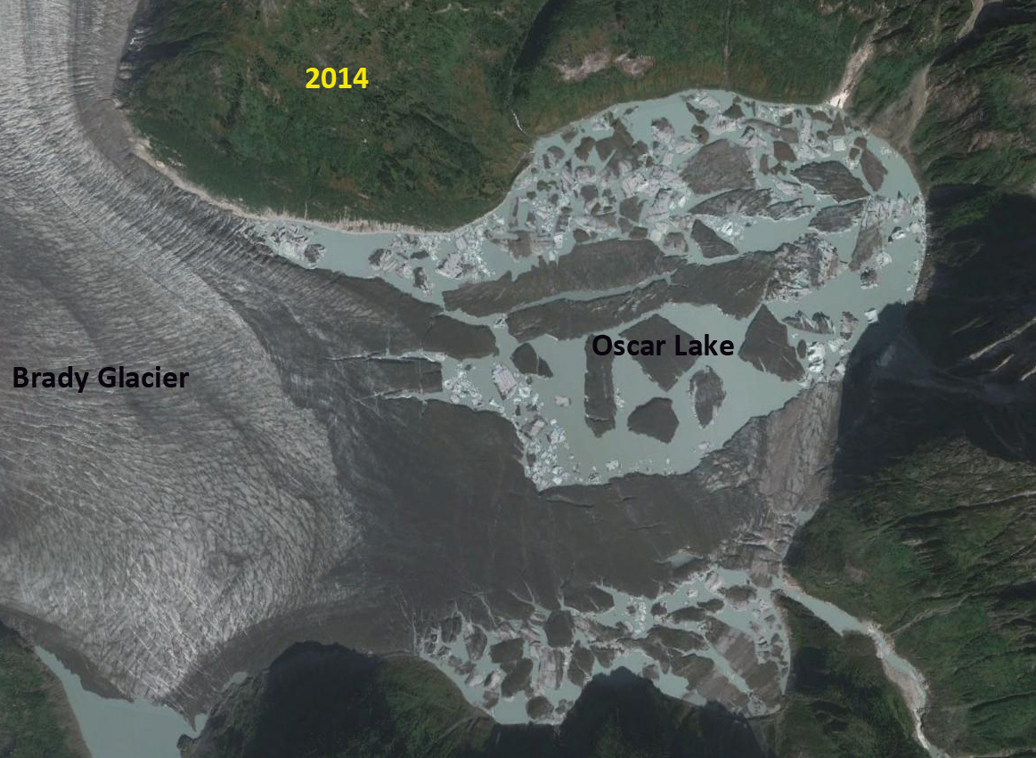
. To the west of Brady Glacier an unnamed glacier arm that used to join a branch of the Brady Glacier has now retreated fully from lake created by its retreat. Note point A in the time sequence below. The retreat from 1950 to 2004 was 3600 meters northeast up the lake basin, top image map from 1950, middle image Google Earth 2004. From 2004 to 2010 the glacier has retreated an additional 600 meters the retreat turning the elbow and now progressing northwest, bottom image 2010 Landsat image. Clearly the Brady Glacier thinning as indicated by tributaries on both its east and west side, continue do demonstrate that a rapid retreat of the main terminus will begin.

Brady Glacier, Alaska begins a substantial retreat

Brady Glacier is a large glacier at the south end of the Glacier Bay region, Alaska. When first seen by George Vancouver it was a calving tidewater glacier in 1794 filling Taylor Bay with ice. Brady Glacier ceased calving and advanced approximately 8 km during the 19th century (Klotz, 1899). As Bengston (1962) notes, the advance is likely another example of an advance following a change from tidal to non-tidal status rather than that of a more positive mass balance. Bengston (1962) further notes that the massive outwash plain at the terminus is primarily responsible for Brady glacier maintaining itself well other glaciers in the Glacier Bay region retreat. The ELA on this glacier is 800 m, the line above which snow persists even at the end of the average summer, this is one of the lowest in Alaska. The main terminus was still advancing in the 1960’s and 1970’s and has managed a 250-300 meter advance since the USGS map of the 1950’s. The main terminus is not advancing any longer and has begun to retreat, the retreat to date is less than 200 meters. The image below is the 1950’s map of the glacier. Brady Glacier is a complex glacier with many subsidiary termini. Echelmeyer, Arendt, Larsen and Harrison from the University of Alaska noted a thinning rate in the mid 1900’s of about 1 meter per year on the Brady Glacier complex. A comparison of 1950’s USGS maps and 2004-2006 satellite imagery indicate all six main subsidiary termini are retreating. The retreat ranges from 200 m in Abyss Lake, 200 m in Trick Lake to 1200 meters in North Deception Lake. The image below is the 2006 satellite image. Compare to the map, Deception has increased in size several fold. North Trick and South Trick Lake are now joined, Trick Lake. Of further interest is the stream draining Trick Lake that sneaks down the west margin of the glacier. This has enabled the water level in the glacier dammed Trick Lake to decline. Note the brown grey “Bath Ring” so to speak above the lake level. The outlet has also been marked in the image below. Pelto (1987) noted that the percentage of the glacier in the accumulation zone was right at the threshold for equilibrium. Subsequent warming of the climate in southeast Alaska and reduced glacier mass balance in the region has initiated this retreat.These termini are all closer to the equilibrium and would respond first to changes in mass balance due to recent warming and consequent measured thinning. This entire line of reasoning must be explored. The glacier is thinning substantially and would appear to be poised for a substantial retreat of the main termini, not just the subsidiary termini.
References not linked:
Bengston, K. recent behavior of Brady Glacier, Glacier Bay National Monument, Alaska. IAHS, 58, 59-77.
Klotz O. 1899: Notes on glaciers of southeast Alaska and adjoining territories. Journal of Geography, 14, 523-534.
Pelto, M. 1987. Mass balance of southeast Alaska and northwest British Columbia glaciers from 1976 to 1984: Methods and Results”. Annals of Glaciology 9: 189–193.