Cummins Glacier Fragmentation, British Columbia


cummins compare 2015
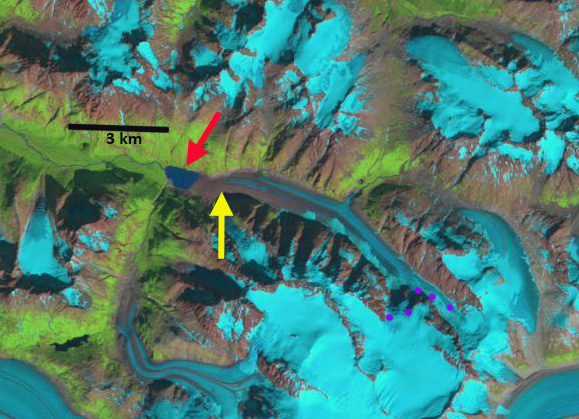
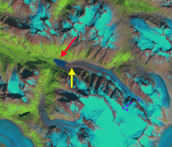
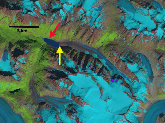
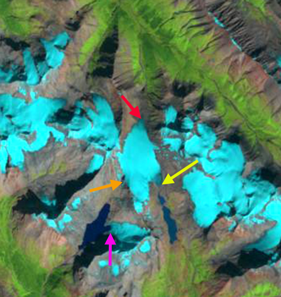
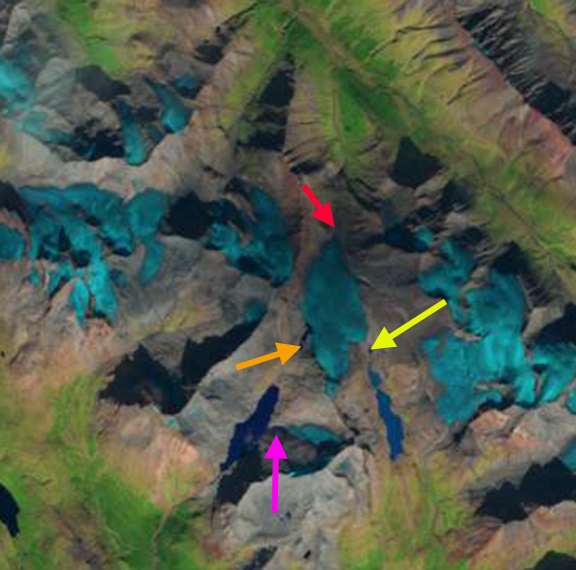
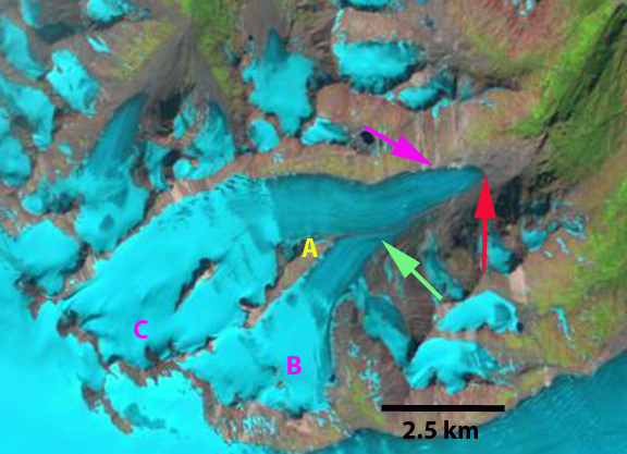
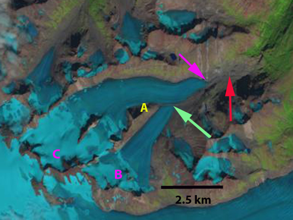
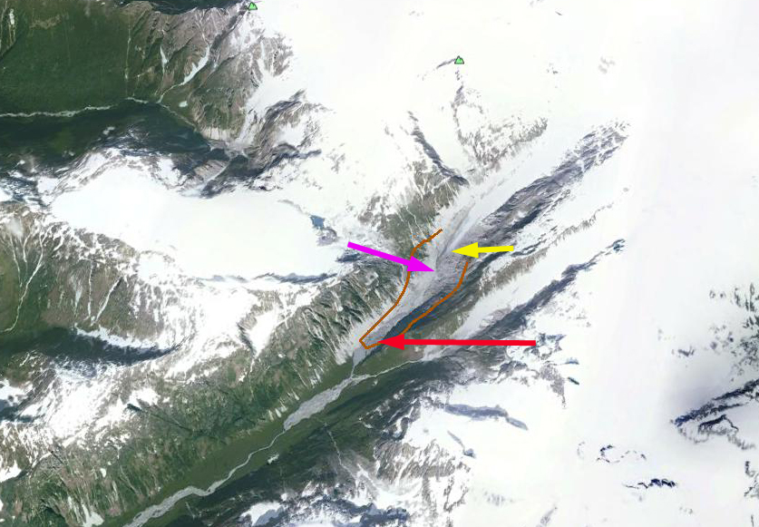
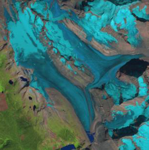
Comparison of the Cummins Glacier from 1986 to 2015.  Purple arrows indicate upglacier thinning and disconnection. Red arrow indicates 1986 terminus position.  Note the lack of snowcover in 2015. 

The Cummins Glacier is part of the Clemenceau Icefield Group in the Rocky Mountains of British Columbia. The Cummins Glacier via the Cummins River feeds the 430 square kilometer Kinbasket Lake, on the Columbia River.  The lake is impounded by the 5,946 MW Mica Dam operated by BCHydro.  Jiskoot et al (2009) examined the behavior of Clemenceau Icefield and the neighboring Chaba Icefield. They found that from the mid 1980’s to 2001 the Clemenceau Icefield glaciers had lost 42 square kilometers, or 14% of their area.  Tennant and Menounos (2012) examined changes of the Rocky Mountain glaciers and found between 1919 and 2006 that glacier cover decreased by 590 square kilometers, 17 of 523 glaciers disappeared and 124 glaciers fragmented into multiple ice masses.  Here we examine the Landsat images from 1986-2015 to illustrate that Cummins is one of those fragmenting glaciers.

cummins map

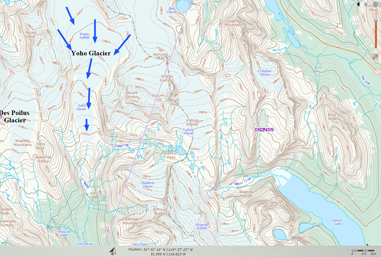
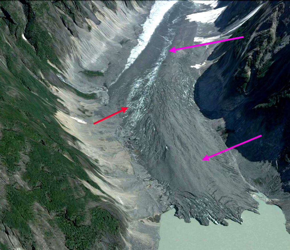
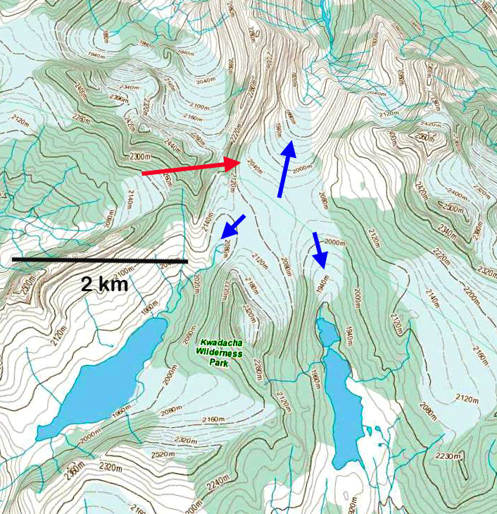
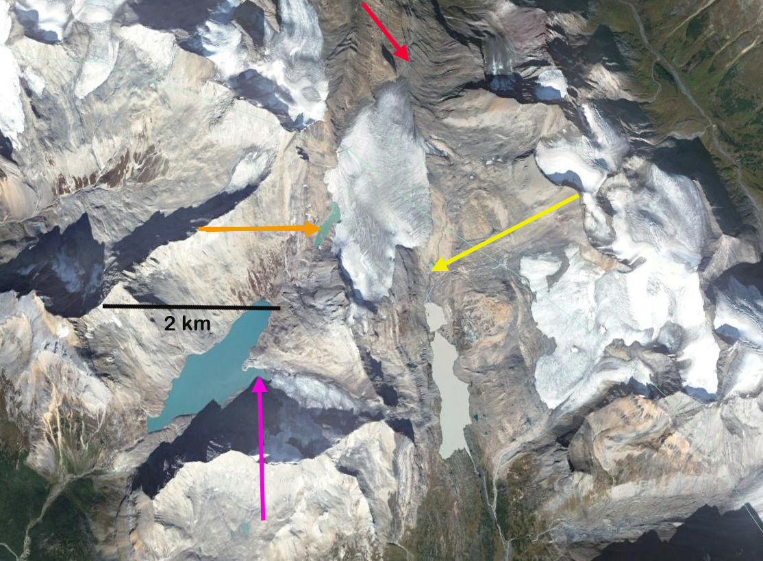
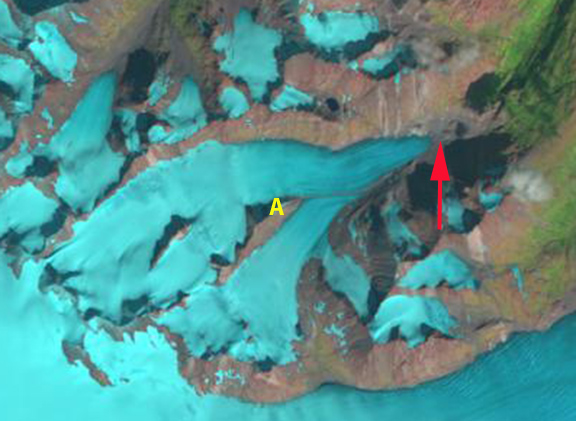
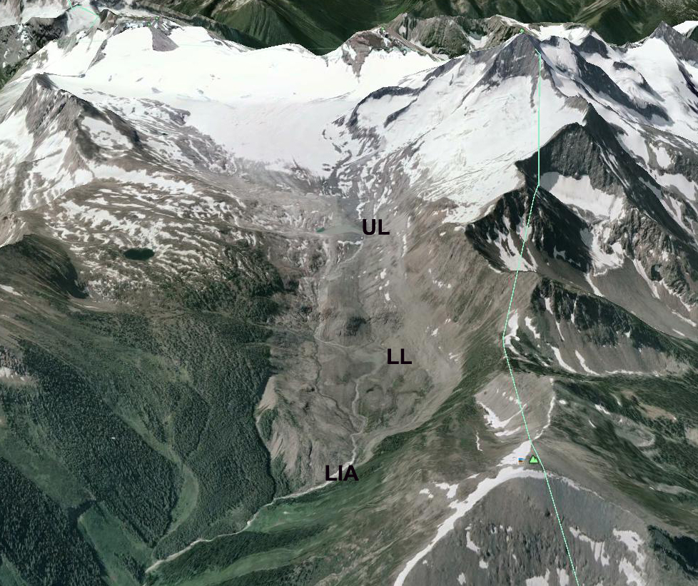
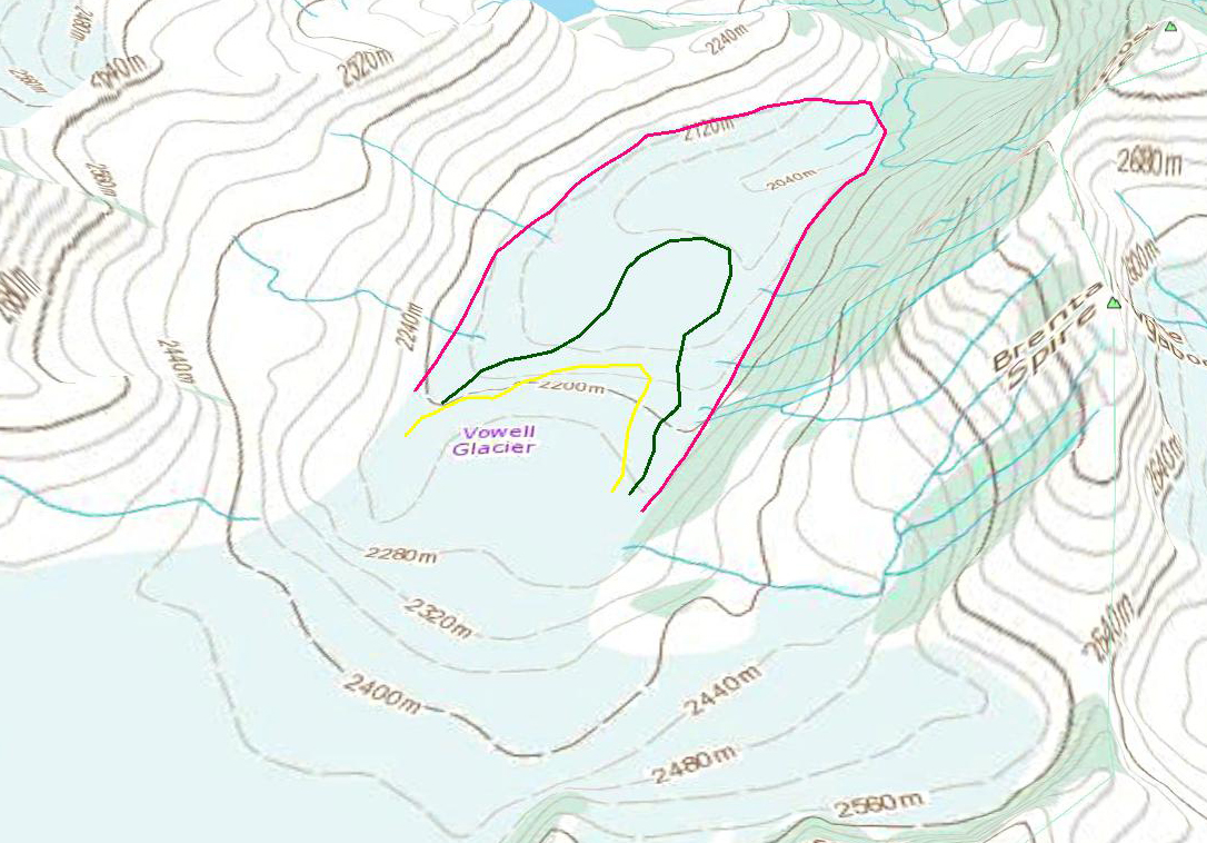
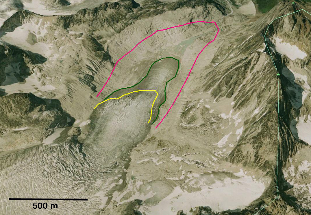
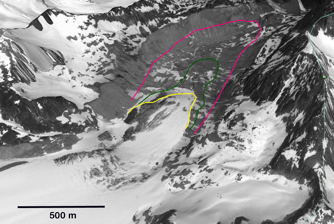
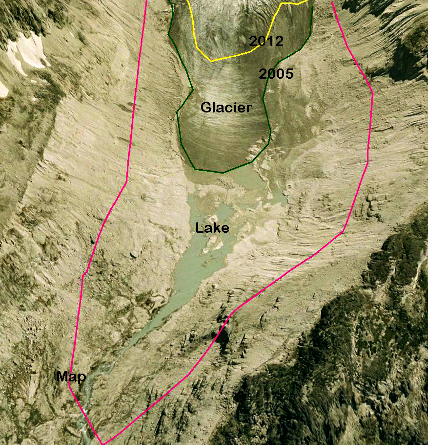
Cummins Glacier on the western side of the Clemenceau Icefield shares a connection with Tusk Glacier.

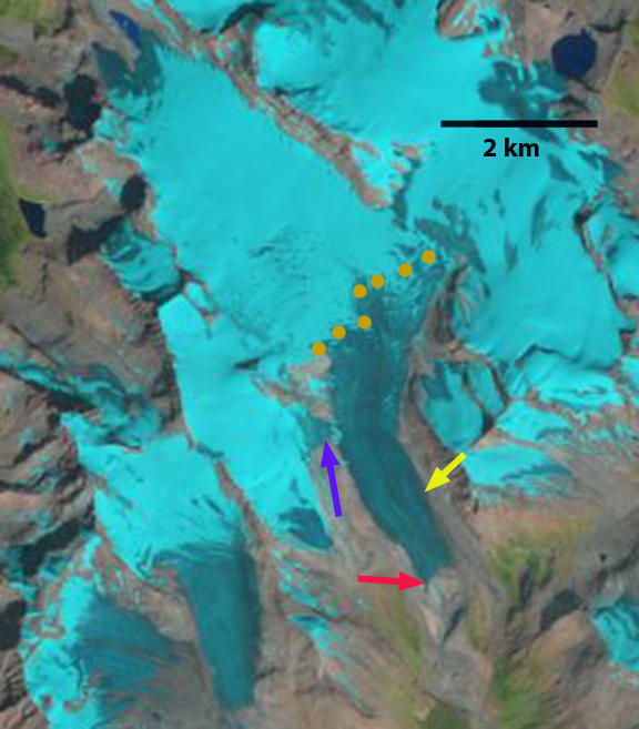
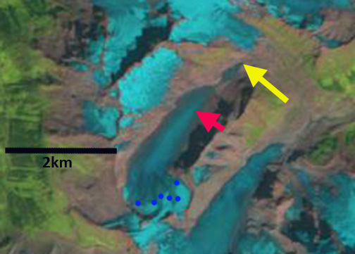
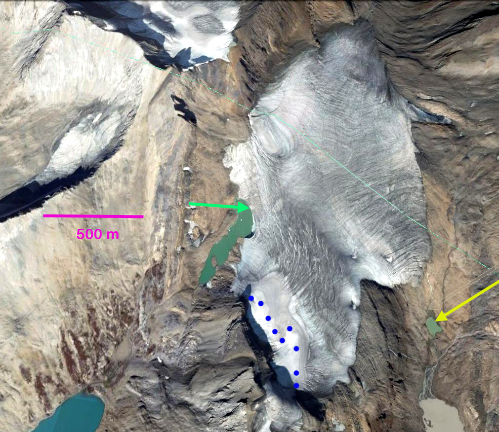
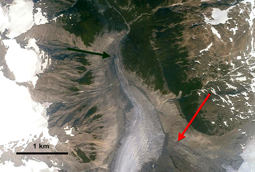
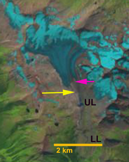
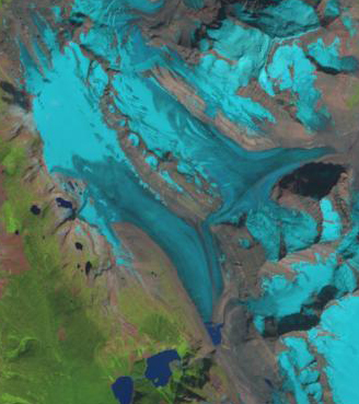
In 1986 Cummins Glacier had a joint terminus with the main southeast flowing branch and the west flowing branch terminating at the red arrow.  The glacier also had a substantial connection, purple arrow,  with Tusk Glacier that flows east terminating northeast of Tusk Peak.  There are other connections with other high elevation accumulation areas, purple arrows.  In 2013 and 2014 Cummins Glacier had less than 20% retained snowcover by the end of the melt season.  Typically 50-65% of a glacier must be snowcovered at the end of the summer season to be in equilibrium.  In 2015 conditions were even worse with no retained snowcover, in fact there is only minor patches of retained firn from previous years.  The lack of a persistent accumulation zone indicates a glacier that cannot survive the climate conditions (Pelto, 2010).  By 2015 a proglacial lake had formed at the terminus that is 500 m long, representing the retreat during the thirty year period.  The west flowing portion of the Cummins has detached from the larger branch.  The connection to Tusk Glacier is nearly severed, and in terms of flow is effectively ended. Retreat of the margin higher on the glacier is also evident at each purple arrow. Tusk Glacier is no longer connected to Duplicate Glacier, and has retreated to the north side of Tusk Peak.  The dominant change in Cummins Glacier has been thinning, it should now be poised for a more rapid retreat.

The result for Kinbasket Lake of the loss of the collective large area is a reduction in summer glacier melt and summer glacier runoff. The annual runoff which will be dominated by annual precipitation would not change just because of the glacier loss as noted in cases like the Skykomish Basin (Pelto, 2011) and on Bridge River (Stahl et al 2008).

cummins 2013

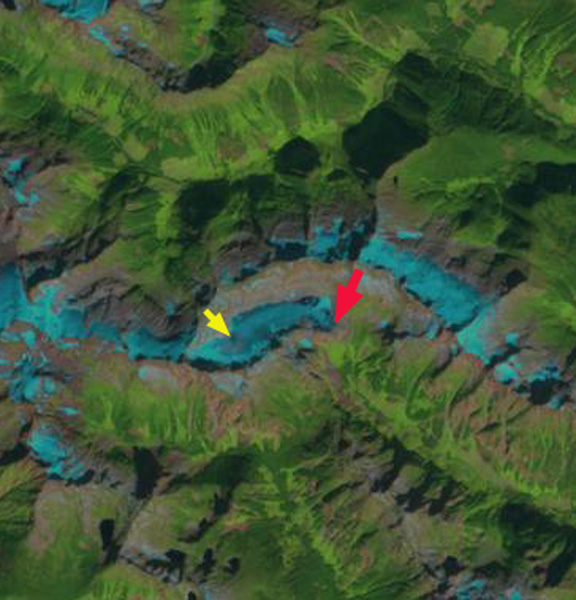
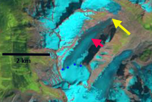
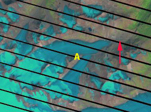
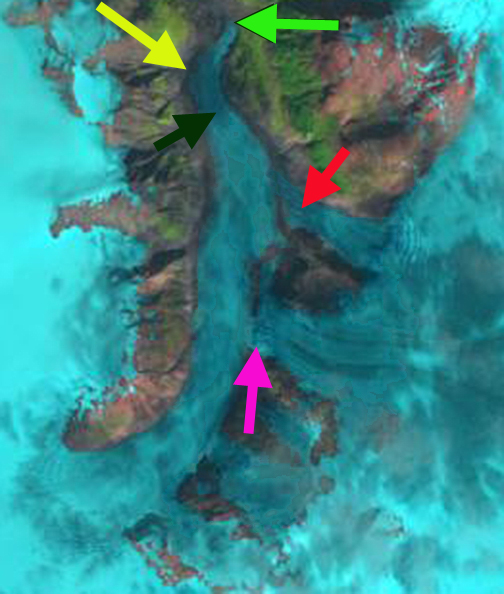
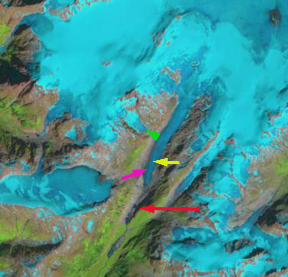
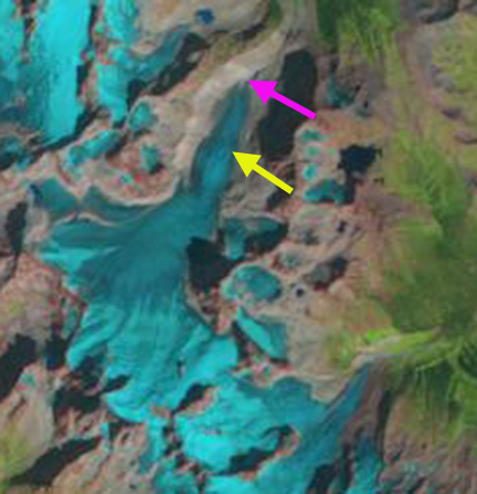
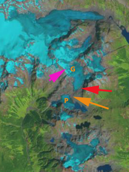
2013 Landsat image indicating 20% retained snowcover with a month left in the melt season.

cummins 2014

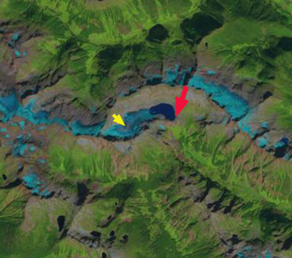
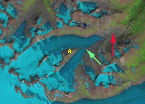
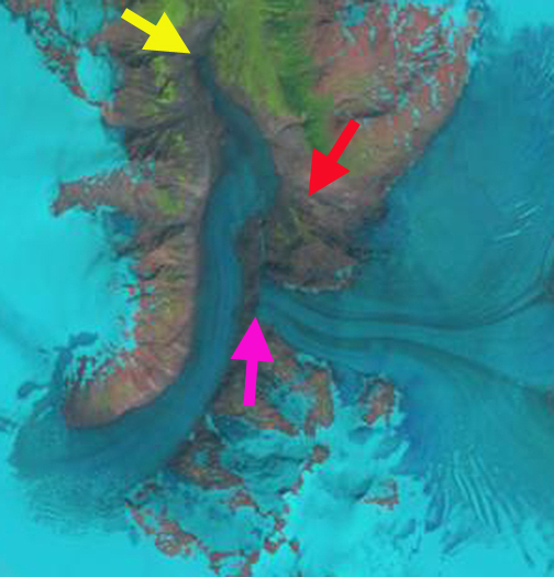
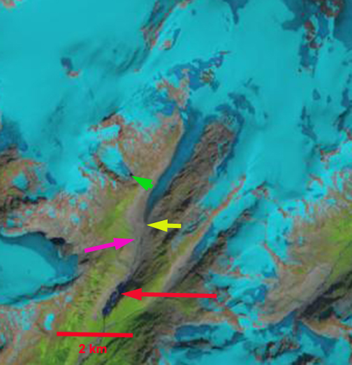
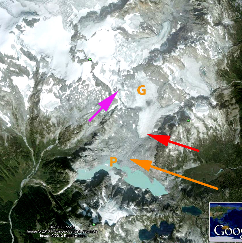
Landsat image 2014 about 25% retained snowcover with three week left in the melt season.

apex-watershed

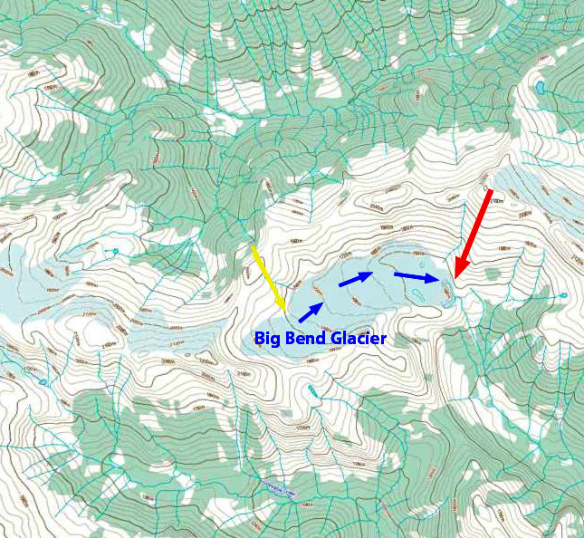
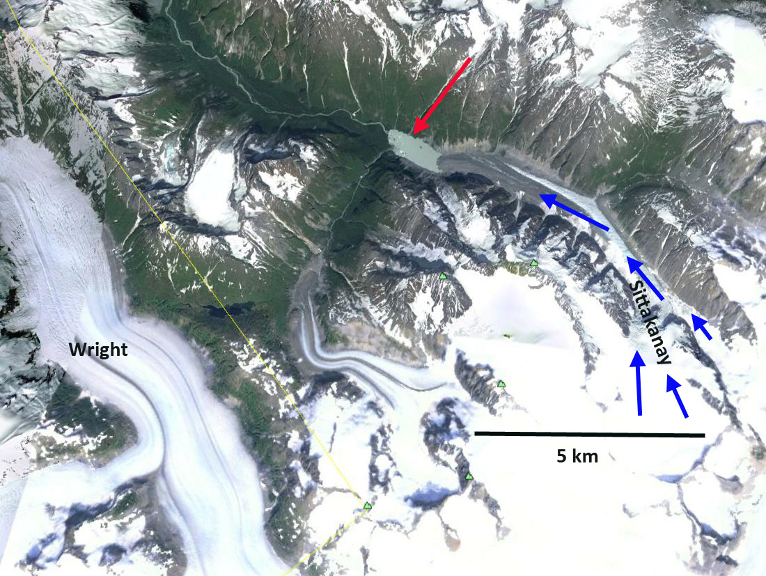
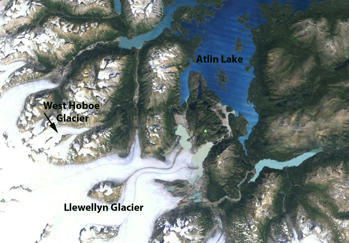
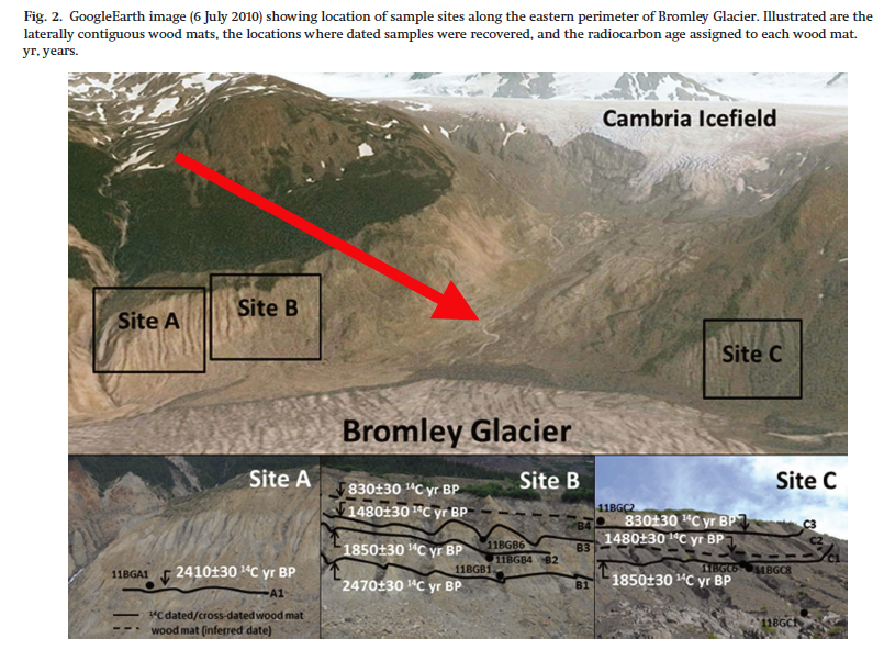
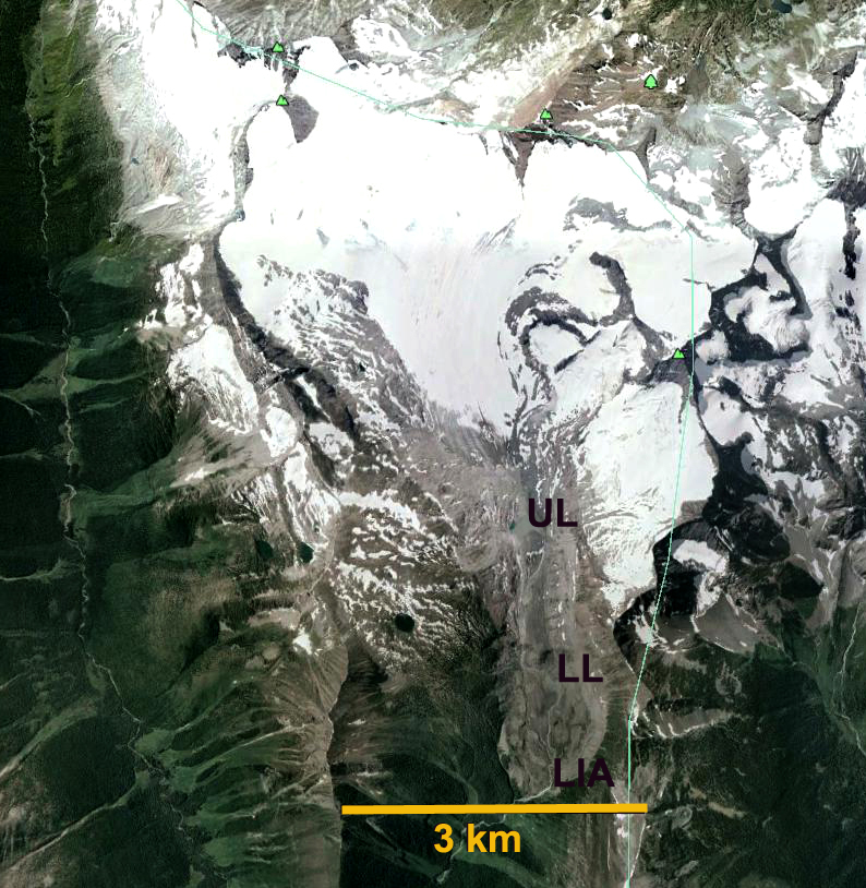
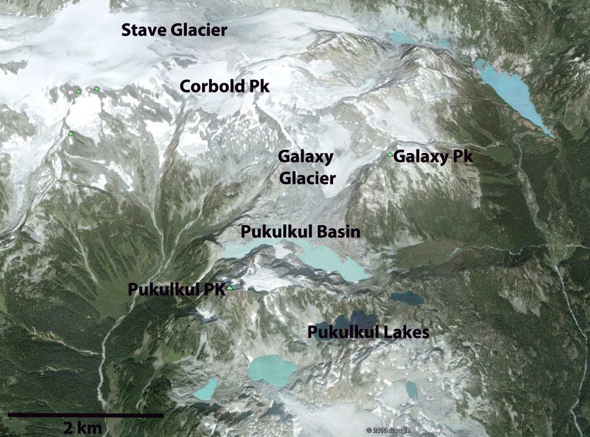
Google Earth Image of Cummins Glacier location to Kinbasket Lake.

Yoho Glacier, British Columbia Accumulation Zone Woes

yoho glacier melt

Yoho Glacier in 2005 no accumulation zone in sight.

Yoho Glacier is the largest southern outflow draining the south from the Wapta Icefield in the Kootenay region of British Columbia. It flows 6.5 km from the 3125 m to a terminus at 2200 m. The glacier terminus reach is thin, gently sloping  and uncrevassed poised for continued retreat. An exploration of Mount Balfour in 1898 a party led by Professor Jean Habel with the packer Ralph Edwards as a guide were the first to visit and describe Yoho Glacier. There descriptions of the magnificent Takakkaw Falls down river of the glacier quickly led to it becoming a frequent destination of visitors. The glacier was also accessible. Retreat up a steep slope at 2000 m made actually visiting the glacier difficult in the middle of the 20th century.  The glacier has retreated 2.1 km in the last century leaving a vast area of bare terrain, dotted by several small new alpine lakes. Here we examine changes in the glacier from 1986 to 2015 with Landsat imagery.

yoho map final
CanadianTopographic map

In 1986 the glacier terminated in a broad 500 m wide glacier terminus at 2150 m, red arrow, the glacier tongue remained wide up to the yellow arrow, 800 m. A tributary connected to the glacier at the purple arrow, and the glacier snowline, orange dots was at 2550 m. In 1998 the terminus had not retreated significantly, but had narrowed noticably. The tributary at the purple arrow was no longer connected and the snowline was at 2750 m, leaving little of the glacier snowcovered, which equates to a significant mass loss. In 2013 the snowline again was high at 2700 m. In 2015 the glacier terminus has retreated 300 m since 1986 and is only 250 m wide. The width at the yellow arrow is 450 m. The width reduction is an indicator of how much the glacier has thinned. The snowline is at 2800 m in this mid-August image, clinging only to the high slopes of Mount Collie, and would still rise for several more weeks in the summer. The nearby Peyto Glacier has an annual mass balance record indicating a thinning of 25 m during this period (Kerhl et al, 2014).  A glacier typically needs more than 50% of its area to be in the accumulation zone at the end of the summer to be in equilibrium.  In recent years when the snowline exceeds 2700 m less than 10% of the Yoho Glacier is in the accumulation zone. If the snowline is as high as it has been recently on Yoho Glacier, that indicates the lack of a significant accumulation zone and it cannot survive even current climate.  However, in both cases the Peyto and Yoho Glacier are rapidly losing volume, but remain substantial in size and are not on the verge of disappearing in the next few decades. The retreat is similar to that of Des Poilus Glacier shown in the lower left of the Landsat images here.

yoho glacier 1986
1986 Landsat Image

yoho glacier 1998
1998 Landsat Image

yoho glacier 2013
2013 Landsat image
yoho glacier 2015
2015 Landsat image

Big Bend Glacier, British Columbia Transitions to Alpine lake

“Big Bend” Glacier is an unnamed glacier west of Big Bend Peak north of Harrison Lake in Southwest British Columbia.  In 1985 the glacier was 2.6 km long filling a low valley with a surface elevation of 1600-1800 m elevation, the topographic map indicates this basic size. Here we utilize Landsat imagery to identify the changes in the glacier from 1985-2014 due to climate change. In essence the glaciated basin is transitioning to an alpine lake basin, quickly.

bigbendpeak ge


Topographic map of the Big Bend Glacier area.

In 1985 the glacier extends to the big bend in the valley marking its eastern end, red arrow.  the yellow arrow indicates an area near 1800 m where the glacier extends across the valley.  In 1992 there has been little retreat but evident thinning is leading to lake formation at the terminus and narrowing of the glacier at the red arrow. In 2002 thinning is leading to expansion of a proglacial lake both west and south of the red arrow.  The terminus retreat has still been limited, thinning is evident at the yellow arrow.  

In 2013 a new alpine lake that is approximately 1 km long has formed, as the terminus area of the glacier has collapsed. In 2014 an area of bedrock and a small lake has developed at the yellow arrow.  There is no retained snowpack below the yellow arrow in 2013, and no retained snowpack in at all in 2014.  This will likely be the case in 2015 as well.  This glacier has a lower top elevation than most in the region and will be more impacted by the warm winter conditions and high snowline of 2015. The retreat from 1985 to 2014 has been 1.1 km. This is 40% of the entire glacier length gone in 30 years. The lake itself has a deep blue color suggesting limited glacier sediment input, further indicating a lack of motion of the glacier currently or in the near past.

The glacier retreat has been more extensive than Stave Glacier or Snowcap Glacier to its east.  Koch et al,(2009) observed a widespread retreat and glacier area loss in Garibaldi Provincial Park just to the west, with 20% area loss from 1988-2005. Place Glacier is a short distance north of Big Bend Glacier has its mass balance has lost an average of 25 m of water equivalent (28 m ice) thickness since 1984, see bottom chart. This has been higher but similar in trend to other glaciers in the region.  Big Bend will disappear soon just as we obsserved already happened at Milk Lake Glacier, North Cascades, Washington.

bigbendpeak1985
1985 Landsat Image

bigbendpeak1992
1992 Landsat Image

bigbendpeak2002
2002 Landsat Image

bigbendpeak 2013
2013 Landsat Image

bigbendpeak2014
2014 Landsat Image

nam-ba-2013
North American cumulative glacier mass balance graph

Sittakanay Glacier Retreat, British Columbia

Sittankanay Glacier drains the north side of the small icefield that feeds the retreating Wright, Speel and West Speel Glacier. The 10 km long glacier is the headwaters of the Sittkanay River, a tributary to the Taku River. Here we utilize Landsat images from 1984-2013 to identify the recent changes in the glacier. The glacier begins at 2000 m and ends in a lake at 250 m, the terminus has heavy debris cover, which is unusual for this area. The Canadian Topographic map indicates a lake that is 400 m long.
sittikanay map
Canada Topographic map

sittakany westge
Google Earth Image

In 1984 the terminus of the glacier, red arrow is at the base of a steep gulch, yellow arrow marks the 2013 terminus. The lake has expanded to 600 m in length. The purple dots indicate the snowline is at 1500 m, which leaves limited snowpack for sustaining the glacier. In 1996 and 1999 the snowline was also at 1500 m, indicating negative mass balances that underlie the retreat. By 2013 the glacier the lake had expanded to 1700 m in length. The glacier has retreated 1100 m since 1984. The snowline is at 1400 m in the mid-August image, and will rise above 1500 m by the end of the melt season. A close up view of the terminus indicates the heavy debris cover has large uncrevassed sections that appear nearly stagnant, pink arrows. There is one feature in the 2006 Google Earth image that is 1.0 km from the terminus, a circular depression-red arrow, with concentric crevasses that indicates a subglacial lake that partially buoys the glacier. This also indicates that rapid retreat will continue. The retreat is enhanced by calving, but it is the insufficient size of the accumulation zone that is driving the retreat of this glacier and its neighbors.

sittakanay 1984
1984 Landsat image

sittakanay 1996
1996 Landsat image

sittakanay 1999
1999 Landsat image

sittakanay 2013
2013 Landsat image

sittakanay terminus
Google Earth image

Haworth Glacier Retreat, Selkirk Mountains, British Columbia

Haworth Glacier in the northern Selkirk Mountains of British Columbia drains into Palmer Creek, which flows into Kinbasket Lake, and then the Columbia River. This glacier is often visited by climbers as the Canadian Alpine Club has a summer base camp near the terminus of the glacier. The glacier has a low slope and limited crevassing that makes it a good training ground for climbing. Menounos et al (2008) noted an advance of this glacier overrunning a stump that has since been exposed by retreat in the period from 3800 years before present, similar in timing to many glaciers in the region. The stump remained buried until recent exposure.
haworth map
Here we examine a series of Landsat images from 1986-2013 to identify the retreat and forecast whether the glacier can survive even current climate conditions. In each image the blue dots mark the snowline, yellow arrow is the 1986 terminus and the red arrow the 2013 terminus. In 1986 the glacier ended near the far end of the basin where a lake has since developed, yellow arrow. Snowcovers 30% of the glacier in the late summer of 1986, 55-65% is necessary for glacier equilibrium. By 1994 the glacier had retreated exposing the new lake basin, the glacier was 25% snowcovered. By 1998 the glacier had retreated 550 m since 1986, the glacier was 15% snowcovered. In 2009 the glacier was 20% snowcovered. In 2013 the glacier terminates at the red arrow indicating a retreat of 1000 m since 1986, 37 m per year. The glacier is 10% snowcovered. The percent snowcover in each year is much less than the 55% minimum needed for a minimum balance, the images are also not precisely at the end of the melt season. If a glacier does not have a consistent and persistent snowcover at the end of the melt season it has no “income” and cannot survive (Pelto, 2010). This glacier has managed to retain a very small area of snowcover, but given the ongoing thinning and the lack of avalanche accumulation on this glacier, it is unlikely to be enough to save this glacier. Bolch et al (2010) noted a 10% area loss for British Columbia glaciers from 1985 to 2005, Haworth Glacier is above this average. Tennant and Menounos (2013) noted that the fastest rate of loss on Columbia Icefield glaciers from 1919-2009 was during the 2000-2009 period. The glacier is not retreating as fast as some of the glaciers that also calve into lakes such as Columbia Glacier, British Columbia. Nearby Apex Glacier has retreated at a similar rate. Jiskoot et al (2009) observed the terminus change of 176 glaciers in the Clemenceau Icefield and adjacent Chaba Icefield, and noted an average retreat of 21 meters per year from the 1980’s to 2001.
haworth galcier 1986
1986 Landsat image

haworth galcier 1994
1994 Landsat image

haworth glacier 1998
1998 Landsat image

haworth glacier 2009
2009 Landsat image

haworth glacier 2013
2013 Landsat image

Kwadacha Provincial Park Glacier retreat, British Columbia

Kwadacha Wilderness Provincial Park in Northern British Columbia is host to numerous glaciers. Here we focus on an unnamed glacier that drains north into the Kechika River, which joins the Laird River. This glacier straddles both a watershed divide. The map of the glacier indicates the three separate termini of this glacier. Bolch et al (2010) noted that this area of BC lost 15% of its glacier area from 1985 to 2005. kwadacha wp glacier ge A comparison of Landsat imagery and Google Earth imagery during the 1994-2013 period indicate the changes to this Kwadacha Park glacier. In 1994 the glaciers three termini are at the red-northern terminus, yellow-southeaster terminus and orange-southwestern terminus arrows. A separate glacier ends at the margin of an alpine lake at the violet arrow. In 1995 there is no snowcover retained on the glacier. In 2001 the terminus at the orange arrow has retreated leading to lake expansion and at the red arrow. By 2013 the glacier’s northern terminus has retreated 250-300 m since 1994 and now terminates at the end of a rock rib. The southeastern terminus has retreated 250 m losing most of this glacier tongue. The southwestern terminus has retreated 300 m, and some calving is occurring. The glacier also has no retained snowpack in 2013. A glacier that consistently loses all of its snowpack cannot survive (Pelto, 2010). This glacier falls into that category. The retreat is evident in the Google earth image with the arrows marking the 1994 terminus locations. A closeup of this image indicates the lack of retained snowcover, blue dots mark snowline. The southwestern terminus calving margin is noted at the green arrow. The near stagnant nature of the northern terminus is also evident with the lack of crevassing. This glaciers will continue to thin and retreat and with current climate will not survive. The retreat is similar to that of other glaciers in the region including Snowshoe Glacier, Yukon, Great Glacier and Freshfield Glacier.
kwadacha 1994
1994 Landsat image

kwadacha 1995
1995 Landsat image

kwadacha 2001
2001 Landsat image

kwadacha 2013
2013 Landsat image

kwadacha ge
2013 Google Earth image

kwadacha close ge
2013 Google Earth image

West Hoboe Glacier Retreat, British Columbia

On the east margin of the Juneau Icefield is a small, compared to other glaciers, 7 km long unnamed valley glacier, here identified as West Hoboe Glacier. Here we use Landsat imagery to identify changes from 1984 to 2013. This glacier is just east of the retreating Hoboe Glacier and Llewellyn Glacier. The glacier flows from 2000 m down to 1250 m and drains into Atlin Lake at the headwaters of the Yukon River. In 2014 the Juneau Icefield research Program is planning to complete field measurements on this glacier for the first time.Atlin bc
Google Earth Image
hoboe view
West Hoboe Glacier is in background of image from the Toby Dittrich led expedition to Mount Service in 2013.

In 1984 West Hoboe Glacier ended at the red arrow below a small cirque glacier south of the glacier. In each image the arrow and letters are in the same location, the pink arrow indicates the 2013 terminus position. Point A indicates a small ice filled basin connected to the West Hoboe Glacier in 1984. The green arrow indicates the junction of the two main arms of the glacier, which has a width of 1100 m. Point B and C are bedrock outcrops in the upper portion of the glacier. By 1993 the glacier has retreated a short distance from the 1984 terminus position, red arrow. By 2004 the glacier has continued to retreat from the 1984 position, red arrow, the tributary glacier junction, green arrow, has been reduced to 900 m. At Point A there is no longer ice in the basin. At Point B the bedrock outcrop exposure has expanded. Both indicate glacier thinning. In 2004 and 2009 snowcover is limited on the glacier. In 2013 a pair of Landsat images, August 1, 2013 and September 2, 2013 indicate that the glacier has retreated 850 m from 1984-2013, now ending at the base of a narrow landslide prone gully. The connection at the green arrow is 800 m, a 300 m reduction in width since 1984. The thinning of the glacier has led to bedrock expansion at Point B and C, this is a 12% reduction in total length. At Point A the separation between the basin and the glacier indicates both marginal retreat and thinning of the glacier. Notice that 70% of the glacier in early September has lost its snowcover. The thinning even at the top of this glacier indicates it will not survive current climate.
hoboe glacier 1984
1984 Landsat image
hoboe glacier 1993
1993 Landsat image
hoboe 8-24-2004
2004 Landsat image
hoboe 8-5-2009
2009 Landsat image
hoboe 8-1-2013
8-1-2013 Landsat image

Hoboe 9-2-2013
9-2-2013 Landsat image

Bromley Glacier Retreat, NW British Columbia

Bromley Glacier is the largest outlet glacier of the Cambria Icefield near Stewart, BC. The glacier drains north into the Bear River. bromley mapDan Smith and his graduate students of the University of Victoria have been busy searching for fossil wood as it emerges from beneath the rapidly retreating glaciers of British Columbia. They have found numerous pieces from former forest that have emerged in the last decade after being buried for at least 2000 years. Smith, points out this is due to the rapid retreat that began in the area in the 1980’s. Bolch et al (2010) noted a reduction of 0.3% per year in glacier area in the Northern Coast Mountains of British Columbia from 1985 to 2005. Scheifer et al (2007) noted an annual thinning rate of 0.8 meters/year from 1985-1999. One of the glacier they visited was Bromley Glacier in 2011. This led to a publication from Smith and Kira Hoffman (Hoffman and Smith, 2013) that found periods of glacier expansion at ca. 2470–2410, 1850, 1450, and 830 years BP.

Here we examine satellite imagery from 1986, 1997, 2010 and 2013. The yellow, red, and green arrows indicate the same location in each image. In 1986 as in the map the Bromley Glacier was comprised of three large glacier tributaries, two flowing from the east red and pink arrow and from due south. In 1986 the eastern tributaries still contributed directly to Bromley Glacier. The terminus was at the lime green arrow, 500 meters beyond a side valley on the west marked by the yellow arrow. In 1997 the tributary at the red arrow is no longer feeding the Bromley Glacier while the tributary at the pink arrow connection has narrowed. The terminus has retreated 200 m since 1986, but still rounds the bend heading northeast. In 2010 the separation at the red arrow is greater than 1 kilometer. The pink arrow tributary is also no longer in contact with Bromley Glacier. The terminus has retreated to the yellow arrow, a 700 m retreat since 1986. The lower 500 meters of the glacier are narrow and thin. By 2013 the glacier has retreated to the dark green arrow, an additional 500 m since 2010 and 1200 m since 1986. The red tributary has retreated 1400 meters from Bromley Glacier and the pink arrow tributary 250 m from Bromley Glacier.

The loss of contributions from two of the three main tributaries will spur continued extensive retreat of the glacier. The snowline of the main glacier has been at close to 1600 m in the imagery here, too high for anything but a very negative mass balance. This retreat is similar to that of nearby Chickamin Glacier, Porcupine Glacier and Nass Peak Glacier. There is an exceptional photo gallery provided by the Tree Ring Lab at University of Victoria, the album does not get to the Cambria Icefield and Bromley Glacier until image 123, though images 65-68 have excellent examples of fossil trees. Figure 2 from Hoffman and Smith (2013) is below. This is in the area rendered ice free by the retreat of the red arrow tributary since 1986. bromley glacier 1986
1986 Landsat image

bromley glacier 1997
1997 Landsat image

bromley glacier 2010
2010 Landsat Image

bromley glacier 2013
2013 Landsat image

Hoffman and Smith Fgiure 2
Figure 2 from Hoffman and Smith (2013) of red arrow tributary that was connected to Bromley Glacier in 1986, this is a 2011 image.

bromley terminus
Google Earth image 2010

Nass Peak Glacier Retreat, Coast Mountains, British Columbia

“Nass Peak” Glacier is a 5 km long unnamed valley glacier that feeds Coast Mountain Creek and then Nass River. The closest community is Kitsault, BC on the north side of the small icefield from which the glacier originates. Nass peak map Here we examine changes in the is glacier in Landsat imagery from 1986 to 2013. In 1986 the glacier terminated at the red arrow, this is also approximately the mapped terminus position. The terminus is near the nose of a long ridge at 650 m in 1986. By 1997 the glacier had retreated 800 m to a location adjacent to the southern outlet stream from another glacier in a side valley. By 2010 the glacier has retreated behond the northern outlet stream of the side glacier, pink arrow and almost too the yellow arrow. In 2013 the glacier has retreated just beyond the yellow arrow a distance of 2000 meters since 1986 and is at an elevation of 850 m. For a glacier that was 7.5 km long and is now 5.5 km long that is a 27% loss of length in 27 years. The green arrow point to the separation between a side glacier and the Nass Peak Glacier, this expanded 250 m both from retreat of the side glacier and the lateral thinning at this elevation of Nass Peak Glacier. The last image is a 2009 Google Earth Image indicating the mapped terminus outline to the 2009 terminus.

The Nass Peak Glacier retreat is larger as a percentage of the glacier, but similar in distance than the nearby Porcupine Glacier, BC, Bromley Glacier, BC, Jacobsen Glacier, BC, Chickamin Glacier, AK and Patterson Glacier, AK. Nass Peak Glacier also has lacked a proglacial lake which typically enhances retreat via calving, making the retreat quite significant in terms of surface mass balance loss.
nass peak 1986
1986 Landsat Image

nass peak 1997
1997 Landsat Image

nass peak 2010
2010 Landsat Image

nass peak 2013
2013 Landsat Image

nass peak ge
2009 Google Earth Image

Toby Glacier Retreat, Purcell Range, British Columbia

Toby Glacier is in the Purcell Mountains of southern British Columbia, part of the Purcell Wilderness Conservancy Park. Here we examine retreat of this glacier from 1998 to 2014 using Landsat imagery and Google Earth images. The map image indicates the Little Ice Age advance moraine (LIA_on other imagers) at 1960 m, a lower lake (LL)at 2060 m, an upper lake (UL) at 2280 m, the former ELA at a slope change at 2500 m and the recent ELA at 2600-2650 m, all images are oriented with north at the bottom. toby map In the 1998 Landsat image the glacier terminates at the yellow arrow 250 m from the Upper Lake. The snowline in 1998 is at 2650 m and only 25% of the glacier is snowcovered. By 2005 in the Google Earth view from 2005 the glacier terminates 450 m from the Upper Lake. In 2013 the glacier terminates 800 m from the Upper Lake, pink arrow. Yellow arrow marks 1988 terminus for comparison. The snowline is again at 2650 m in 2013 with a month left in the melt season, no more than 20% of the glacier will be snowcovered by the end of the summer. In 2014 on Aug. 18th the snowline is between 2600 and 2650 m with six weeks left in the melt season, purple dots. By the end of the summer little will remain snowcovered. The terminus has retreated additionally from 2013 but not an amount that can be assessed accurately. Typically 60% snowcover is necessary for glacier equilibrium. The result of the substantial negative mass balance that result from the high snowlines and small accumulation zone will be continued retreat. There are significant bedrock areas emerging in the upper portion of the glacier indicating a lack of a persistent accumulation zone indicative of a glacier that cannot survive (Pelto, 2010). A glacier lacking a consistent accumulation zone is experiencing a disequilibrium response to climate and cannot retreat to a point of equilibrium. This is exemplified best in an image from Wildair Photography-image 36. The glacier retreat is like that of Vowell Glacier and Conrad Icefield in the nearby Bugaboos. TOBY GLACIER 1998
1998 Landsat image
TOBY GLACIER 2013
2013 Landsat image
toby glacier 2014
2014 Landsat image
toby glacier tiltview
2005 Google Earth view

toby glacier ge
2005 Google Earth view

Vowell Glacier Rapid Retreat, Bugaboos British Columbia

Vowell Glacier is the largest glacier of the Bugaboo’s or maybe was. The glacier drains to the north into Vowell Creek has retreated quite rapidly from 1998 to 2013 creating a new lake and then retreating from that lake. Here we use a sequence of Landsat and Google Earth images to identify the changes from 1998 to 2013. In 1998 Landsat imagery shows the glacier to be 5.5 km long ending at 2060 m with no sign of a lake, this is also the size of the glacier in the BC 20,000 scale topographic map. vowell glacier overview
Vowell Glacier Google earth image from 2005 Pink line map-1998 terminus, green line 2005 terminus, yellow line 2012 terminus.
bugaboo map
Topographic map of Vowell Glacier

vowell glacier 1998 ls
Landsat image from 1998

The pink arrow in each image indicates the 1998 terminus and the yellow arrow the 2013 terminus. By 2005 Google earth imagery indicates a 800 m retreat from the map position and the formation of a proglacial lake with numerous icebergs and residual glacier pieces. The lower 500 m of the glacier is stagnant, uncrevassed and thin at this point. By 2012 Google Earth imagery indicates the glacier has retreated from the lake and is now 1500 m from the mapped position. The 2013 Landsat indicates a terminus retreat in 15 years of 1550 m. vowell glacier map overlay
Mapped extent of glacier overlain in Google Earth

vowell glacier 2005
2005 extent in Google Earth image

vowell map overlay
2012 extent in Google Earth image

vowell glacier terminus 2005
Close up of terminus in 2005

A wonderful image from Canadian Mountain Holidays Heli Ski Guide Lyle Grisedale shows the glacier in 2013. The yellow arrows indicate the current terminus, the burgundy arrows lateral moraines, red arrows glacier peices in the lake and the magenta arrow a detached portion of ice cored moraine.The glacier is flowing with some vigor through the icefall that extends from 2400 m to 2200 m. The lower 400 m of the glacier still appears stagnant and poised for retreat. Worse is the fact that the August 22nd image from 2013, with a month of melting to go, shows the snowline at 2600 m. The snowline will likely rise 200 m by the end of summer leaving only 25% of the glacier snowcovered. A glacier such as the Vowell would need about 60% snowcover to have an equilibrium mass balance for the year. This glacier is retreating more rapidly than the more famously named adjacent Bugaboo Glacier. CMH Bugaboos: Aug 25, 2013

Galaxy Glacier Rapid Retreat, Pukulkul Basin Glacier disappears, British Columbia

Over the ridge south from Stave Glacier is a 1.5 km long unnamed glacier, that is on the west flank of Galaxy Peak, hence referred to here as Galaxy Glacier. The glacier is in Garibaldi Provinical Park, British Columbia. galaxy areaKoch et al (2009) in their detailed survey of glaciers in the park chronicled the Park’s glacier retreat from 1952 to 2002. Koch et al (2009) Found that all 45 glaciers are retreating, and Stave Glacier was experiencing its fastest retreat from 1976-1996, with a 750 m retreat. Satellite imagery from 2012 indicates the Stave Glacier retreat rate from 1996 to 2012 is 1600 m or 100 m per year, even faster. Here we utilize Landsat imagery from 1985, 1987, 1992 and 2009, plus Google Earth imagery form 2006 to examine the retreat and separation of Galaxy Glacier. The orange arrow indicates the terminus of the Galaxy Glacier (G) in 1985 where it joined the glacier (P) in the Pukulkul Basin where several lakes have been forming. This basin is just north of Pukulkul Peak. In 1985 Galaxy Glacier and the Pukulkul Basin Glacier are joined at the orange arrow, the red arrow marks the 2009 terminus and the purple arrow indicates the connection to the highest accumulation area on the east slope of Corbold Peak. By 1987 Galaxy Glacier has separated from the Pukulkul Basin Glacier, the latter has an area of 0.45 square kilometers and is larger than the lake it ends in. By 1992 the Galaxy Glacier is separated by 500 meters from Pukulkul Basin Glacier. The area of bare rock at the purple arrow at the top of Galaxy Glacier has expanded. By 2006 the Pukulkul Basin Glacier is gone and a 2.5 km long series of lakes is in its place. Galaxy Glacier has retreated 800 m from the new lake, and 650 meters from its 1985 position. The purple arrow indicates two large rock outcrops effectively ending significant glacier inflow from the upper east slopes of Corbold Peak. By 2009 the Pukulkul Basin Lake has a deeper blue as the glacier input has declined. The glacier is 90% bare of snowcover and the bedrock at the purple arrow has continued to expand. A closeup of the glacier from the 2006 Google Earth imagery indicates exposed firn layers at the blue arrows. This indicates that all the snowcover not just from the most recent winter has been lost but a number of previous winters as well. This is indicative of a glacier that has no consistent accumulation zone and cannot survive (Pelto, 2010). This glacier similar to the nearby Helm Glacier cannot survive current climate. The purple arrows indicate the limited connection to the upper slopes of Corbold Peak. The red arrow indicates the current terminus position. Galaxy Glacier has lost half of its area in the last 25 years, and the 800 m retreat is one-third of its total length. galaxy glacier 1985
1985 Landsat

galaxy glacier 1987
1987 Landsat

galaxy glacier 1992
1992 Landsat

galaxy glacier 2006
2006 Google Earth

galaxy glacier 2009
2009 Landsat

galaxy glacier closeup
2006 Google Earth Cloesup