Hornopirén Glaciers, Chile continue a Spectacular Retreat 1985-2022

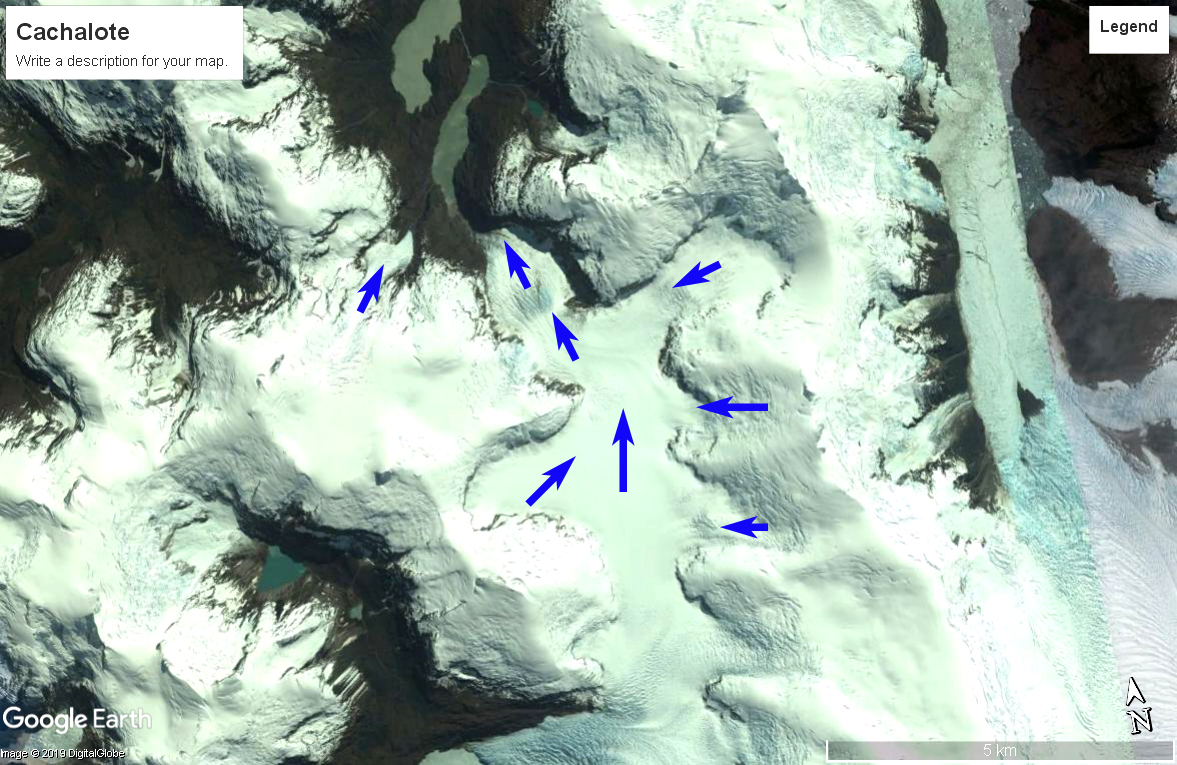
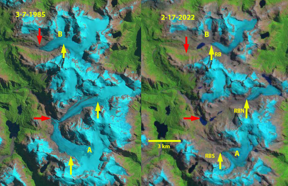
Rio Blanco Glaciers in Hornopirén Naitonal Park, Chile in Landsat 5 and 9 images from 1985 and 2022. Red arrows indicate 1985 terminus position, yellow arrows 2022 terminus position. Point A is an emerging bedrock nunatak and Point B is where tributary separation has occurred.

Hornopirén National Park is in the Los Lagos region of Chile.  The park is host to a number of glaciers that are in rapid retreat.  Davies and Glasser (2012) mapped the area of these glaciers with 113 km2 in 1986 and 96  km2 in 2011.  The retreat of the largest glaciers in the park is spectacular in recent years.Barcaza et al (2017) indicate that Inexplorado glaciers have lost 0.46-0,48 km2 from 2003-2015. Here we examine Landsat imagery to identify changes in three of the larger valley glaciers from 1985-2022.  These glaciers from the headwaters of the Rio Blanco and are designated Inexplorado (RB), Rio Blanco North (RBN), Rio Blanco South (RBS).  Rio Blanco enters the ocean just east of the community of Hornopirén.

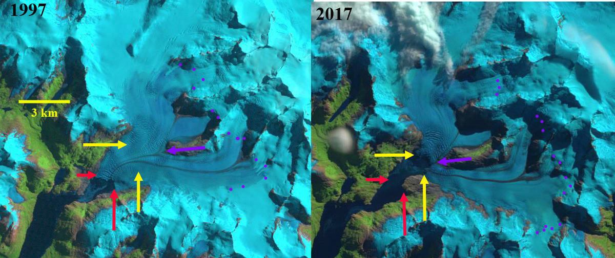
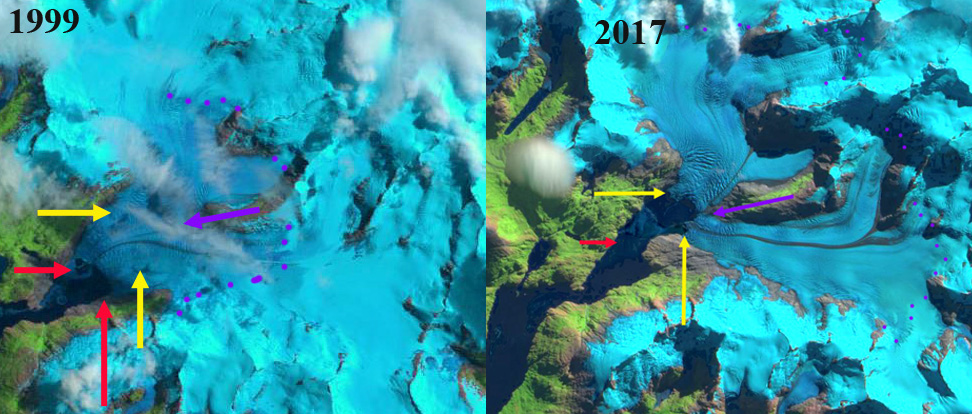
In 1985 the 8 km long RBN and RBS glaciers merged just above the terminus at 820 m, red arrow. In 1985 Inexplorado  (RB) was a 7.5 km long glacier terminating at The snowline was at 1300 m.  By 2001 RBN and RBS had separated by ~1 km with the formation of a new lake at the former terminus. RBS is developing a nunatak at Point A. Inexplorado had retreated 1 km with a proglacial lake just beginning to develop at the terminus, while the northern tributary at Point B is still feeding the main glacier. By 2016 the retreat of RBN has led to the development of  three new alpine lakes in the deglaciated valley.  By 2016 RBS thinning and retreat has led to the Point A nunatak in the lower section of RBS becoming a significant bedrock exposure.  In 2016 The retreat of Inexplorado has led to the formation of a nearly 0.9 km long proglacial lake and the former northern tributary at Point B has separated.  By 2022 RBN has retreated 4.8 km losing 60% of its length since 1985, it has detached from the accumulation and the eastern margin has two lobes now terminating in proglacaial lakes.  RBS has retreated 4 km, losing 45% of its length since 1985. Point A is beginning to merge with terminus and the main terminus is likely retreating into a new lake basin. Both RBS and RBN terminate at ~1200 m. Inexplorado has retreated 2.3 km since 1985, 30% of its length, and is still 5.3 km long, terminating at ~1300 m,  A new lake basin will likely form between the current terminus and the base of the cefall 1.5 km upglacier of the terminus. The snowline in 2015, 2016 and 2022 was at 1600-1700 m.  This leaves only a small percentage of the glacier area above the snowline. The large valley glaciers that just 30 years dominated the headwaters of Rio Blanco have lost ~50% of their length and area and will soon be small slope glaciers clinging to the highest peaks.  Retreat here is more extensive than seen 100 km to the northwest at Calbuco Volcano or to the south at the Quelat Glacier Complex.

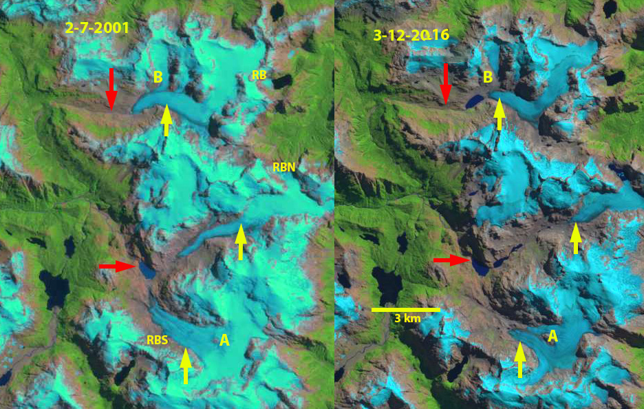
Rio Blanco Glaciers in Hornopirén Naitonal Park, Chile in Landsat 7 and 8 images from 2001 and 2016. Red arrows indicate 1985 terminus position, yellow arrows 2022 terminus position. Point A is an emerging bedrock nunatak and Point B is where tributary separation has occurred.

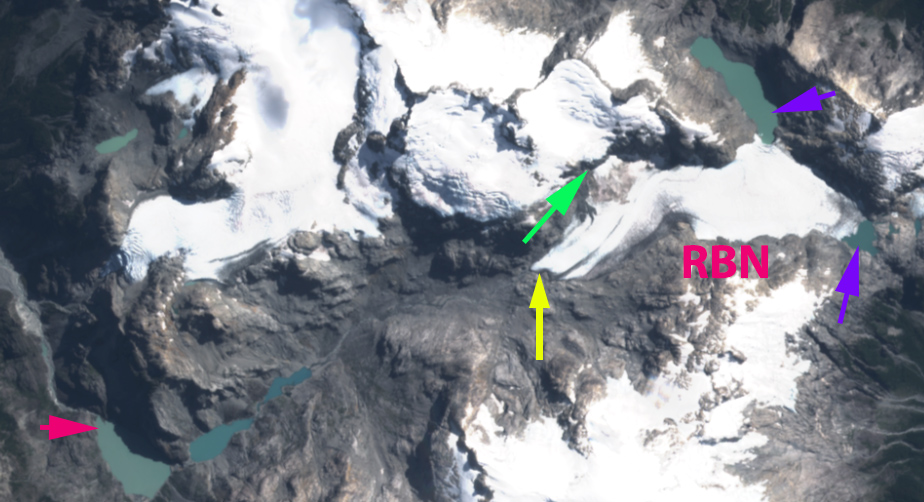
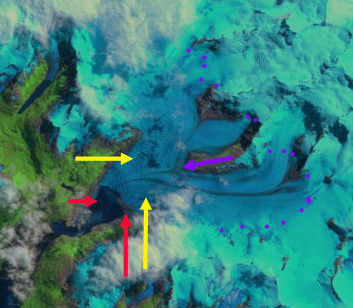
The Rio Blanco North Glacier in March 2022 Sentinel image indicating the two proglacial lakes on eastern margin, purple arrows, the detachment at the green arrow, 1985 terminus locaiton red arrow and 2022 terminus location yellow arrow.

Tres Puntas Glacier, Chile Loses 50% of its Length this Century

Tres Puntas Glacier, Chile in 1999 and 2021 Landsat imagery. Red arrow is 1999 terminus location, yellow arrow the 2021 location, Point A is where tributaries joined in 1999 and Point B is where an adjacent glacier drains west.

Tres Puntas Glacier flow south from Cerro Tres Puntas draining south into Lago O’Higgins in Patagonia. The icefield is east of the Patagonia icefields where Davies and Glasser (2012) noted the nearby (50 km se) Lago Del Desierto glaciers lost 0.6% of its glacier area from 2001-2011, a much higher rate than from 1986-2000.

In 1999 the glacier is 5.6 km long with two significant tributaries joining at 850 m (Point A) before terminating in a proglacial lake at 600 m. The glacier shares a broad divide near Point B with glacier flowing west. In 2002 the snowline is at 1100 m, the terminus is still terminating in the proglacial lake. By 2020 the glacier tributaries have separated and now terminates at 900 m, above Point A. At Point B there is a separation between this glacier and the glacier draining west. By mid-February of 2021 the west tributary has retreated 2.8 km, 50% of its 1999 length, while the eastern tributary has retreated 2.4 km of its 5.0 km length. The snowline in mid-February of 2020 and 2021 has been at 1200 m, above the median glacier elevation. Further retreat of the eastern arm should lead to an additional alpine lake forming.

The retreat of this glacier is more extensive than that of the nearby Sierra Sangra glaciers,  Argentina.  The retreat from an expanding proglacial lake also has played out at Cordillera Lago General Carrera Icefield, Chile

Tres Puntas Glacier, Chile in 2002 and 2020 Landsat imagery. Red arrow is 1999 terminus location, yellow arrow the 2021 location, Point A is where tributaries joined in 1999 and Point B is where an adjacent glacier drains west.

Cachalote Glacier, Chile Retreats From Lake and Separates

Cachalote Glacier in a 1984 Landsat image and 2019 Sentinel Image.  Red arrow is 1984 terminus location, yellow arrow the 2019 terminus location and the pink arrow a tributary to the glacier in 1984 that separates.

Cachalote Glacier is on the western edge of the Southern Patagonia Icefield, Chile. The glacier is not fed by the main icefield, but is connected to glaciers that are.  The glaciers of the SPI have been experiencing significant mass loss and overall retreat. Willis et al (2012) observed significant mass loss from 2000-2012 of −20.0  Gt per year. Davies and Glasser (2012) indicate this area had its most rapid retreat of the 1870-2011 period after 1986.

In 1984 Cachalote Glacier terminated in a proglacial that was ~600 m long, red arrow.  The glacier was joined by a tributary from the west ~1 km from the terminus, pink arrow.  By 2001 the tributary had separated from the main glacier. The glacier still terminated in the proglacial lake, but had retreated 1.5 km and the proglacial lake was now just over 2 km long.  In 2017 the glacier no longer reached the proglacial lake. In 2019 the glacier has retreated 2.6 km from its 1984 position, 30% of its entire length lost in the span of 35 years. The glacier no longer terminates in a lake and ends near the top of a steep slope, both suggest that retreat should decline for the near future.

This is a less spectacular retreat than at HPS-12 Glacier which is a short distance to the norther and is the fastest retreating glacier in the region or Dickson Glacier on the east side of the icefield, but as a percent of glacier length lost is as substantial.

Cachalote Glacier in a 2001 and 2017 Landsat images.  Red arrow is 1984 terminus location, yellow arrow the 2019 terminus location and the pink arrow a tributary to the glacier in 1984 that separates by 2001.

Cachalote Glacier with flow lines indicated. 

Ventisquero Grande Glacier, Chile Retreats; Not so Grande in 2017

Ventisquero Grande Glacier comparison in Landsat images from 1997 and 2017.  Red arrows mark the 1997 terminus, yellow arrows the 2017 terminus, purple dots the snowline and purple arrow the junction of the tributaries. 

Ventisquero Grande Glacier is at the head of Ventisquero Seno in the Cordillera Darwin of Tierra del Fuego.  The fjord is just west of Garibladi Fjord and opens into Darwin Channel.  Melkonian et al (2013) note widespread thinning of four large glaciers in the Cordillera Darwin Range from 2000-2011; Ventisquero Grande (CDI-08), Marinelli, Darwin and Roncagli, while the Garibaldi Glacier increased in volume.  Here we examine changes in the glacier using Landsat and Sentinel Images from 1997 to 2017.

In 1997 two tributaries merged 3.2 km upglacier of the terminus, purple arrow, terminating in a 1.8 km wide calving front, red arrows.  In 1999 there is limited retreat and the calving front has extended to 2 km in length.  The transient snowline is at 700 m in 1997 and at 550 m in 1999, purple dots.  By 2002 the southern end of the terminus has retreated exposing a shoal.  By 2017 the  two tributaries have separated, purple arrow.  Retreat of the glacier has been 2100 m on the north side, 2800 m in the center and 2000 m on the south side. Both of the termini are still calving and extensive crevassing immediately upglacier of the terminus indicates significant glacier velocities.  The calving front is 2.1 km wide in 2017.  As Simon Gascoin has noted the addition of Sentinel imagery has helped expand the potential for images that are relatively cloud free. Melkonian et al (2013) note velocities of less than 2 m/day until right near the terminus. The transient snowline in 2017 is at 800 m on March 28, 2017. 

Ventisquero Grande Glacier comparison in Landsat image from 1999 and Sentinel 2 image from 2017.  Red arrows mark the 1997 terminus, yellow arrows the 2017 terminus, purple dots the snowline and purple arrow the junction of the tributaries. 

Ventisquero Grande Glacier  in 2002 Landsat image. Red arrows mark the 1997 terminus, yellow arrows the 2017 terminus, purple dots the snowline and purple arrow the junction of the tributaries. 


Ventisquero Grande Glacier in Sentinel 2 image from 2017.  Red arrows mark the 1997 terminus, yellow arrows the 2017 terminus,  and purple arrow the junction of the tributaries.