Novatak Glacier, Alaska Rifting in 2025 Reveals Forthcoming Rapid Lake Development in 2025

A network of extensive rifts have developed since 2023, yellow arrows. The fringing proglacial lake has not expanded. Rifting indicates uplift from partially floating glacier area.

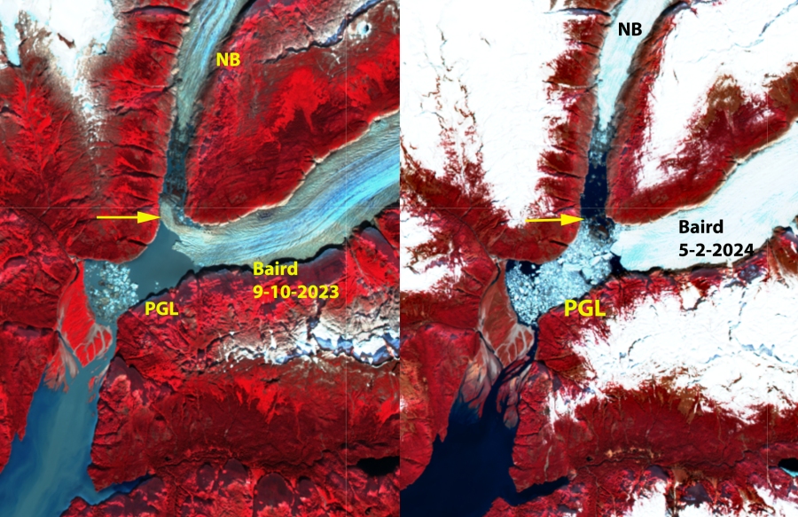
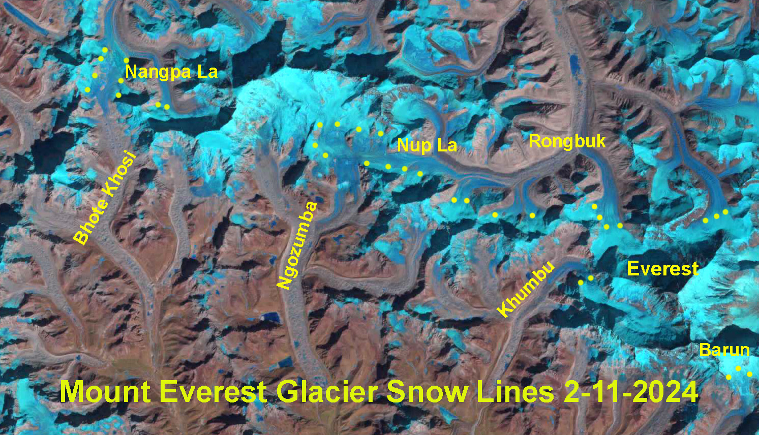
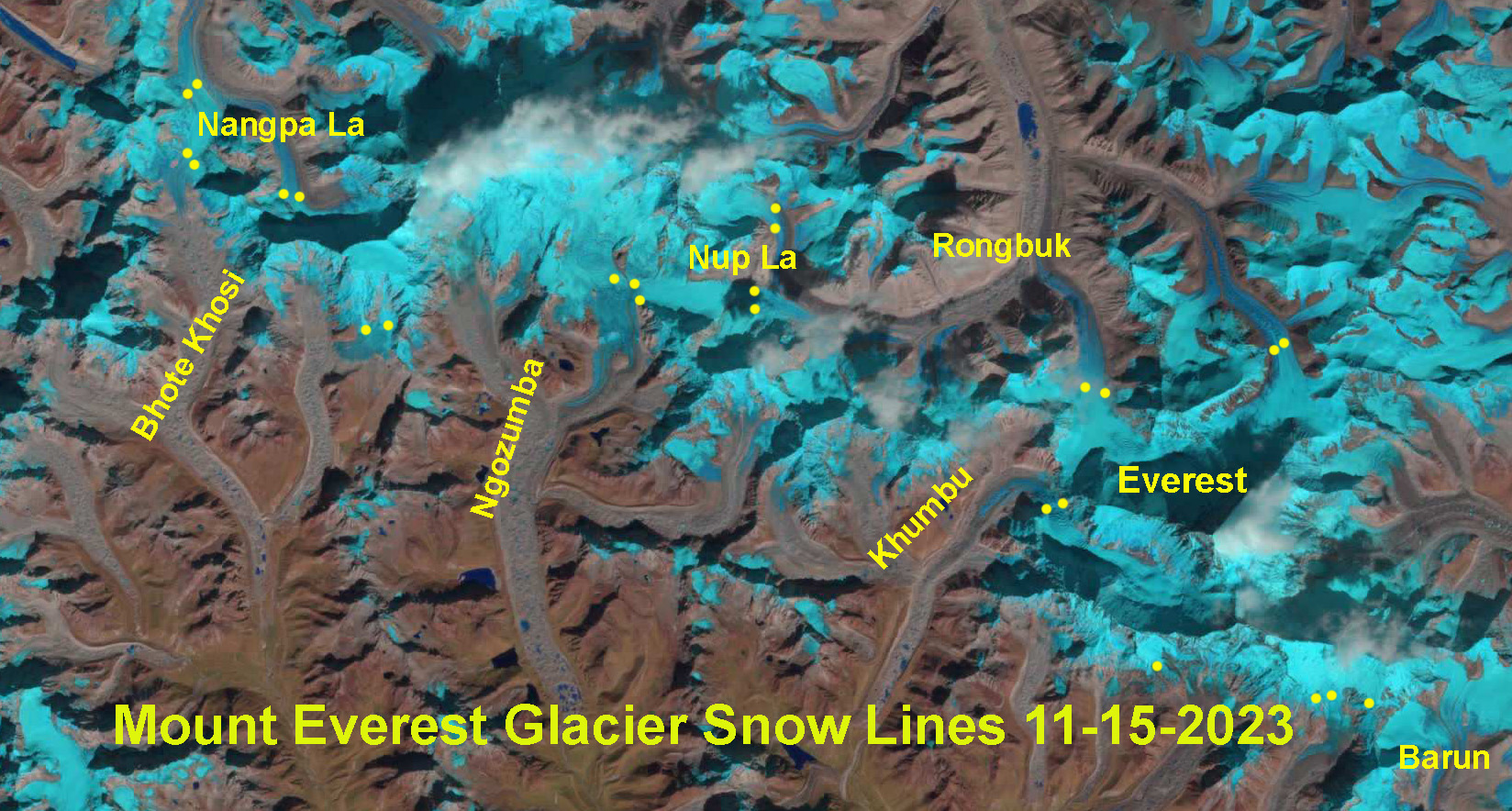
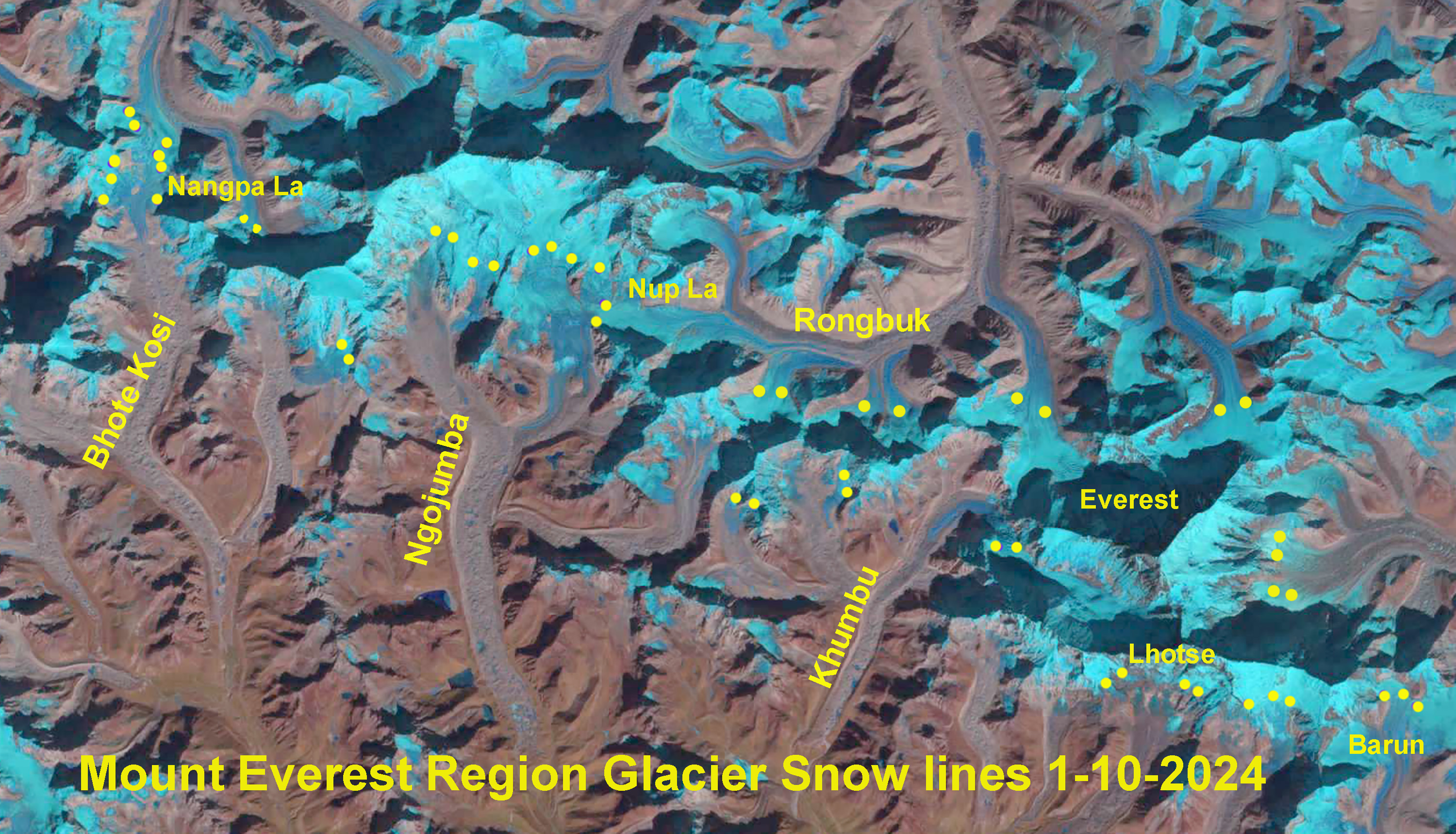
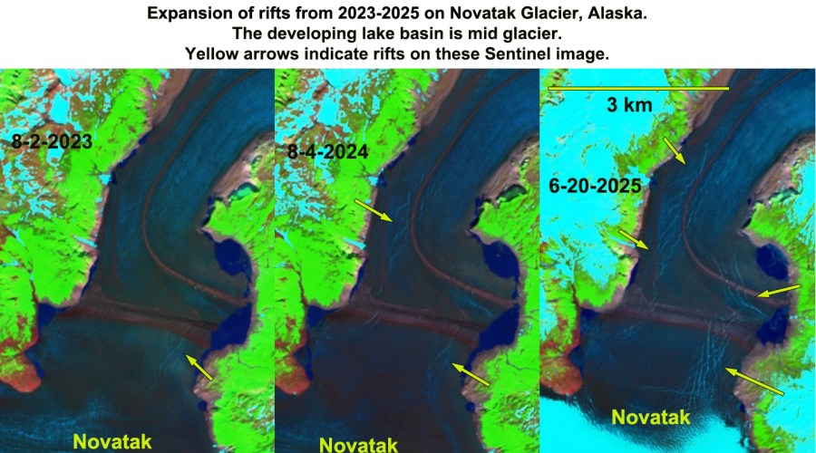
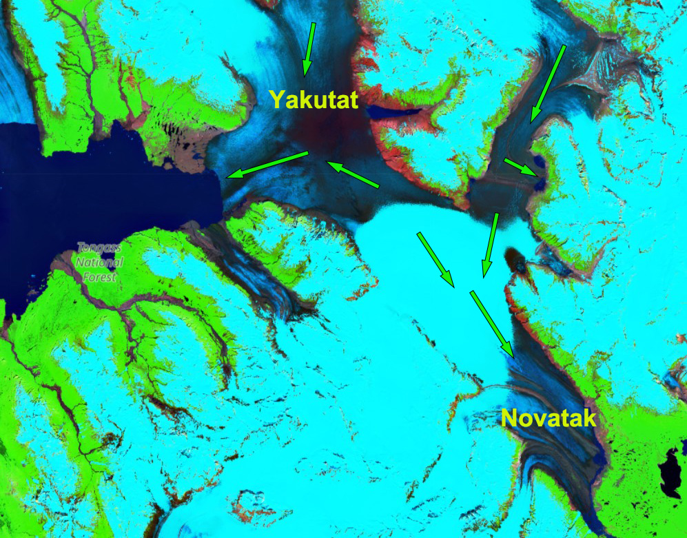
Ice flow in the region around the developing lake, which is near the boundary with Yakutat Glacier in Sentinel Image from June 20, 2025

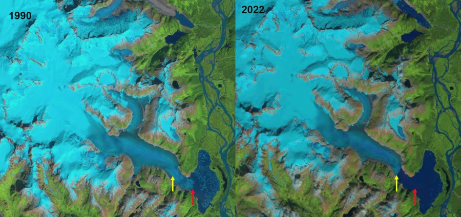
Novatak Glacier is between the Yakutat and East Novatak Glacier in southeast Alaska. The glacier retreated 1 km from 1987-2023 (NASA EO, 2015). The majority of the accumulation zone of these three glaciers is below 1000 m, which has made them particularly vulnerable to the warming climate. The result has been expansion of the proglacial lake, Harlequin Lake, at Yakutat Glacier from 1984 to 2024 from 50 km2 to 108 km2 (Pelto & NASA EO, 2024). There was no lake in 1908.

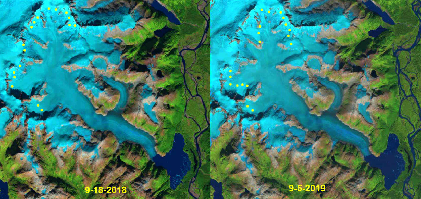
Novatak Glacier has been slow to form a substantial terminus lake unlike its neighbors, possibly because it lacks a sufficient basin. This has limited the retreat of this glacier as it thins. The developing rifts does show a large lake will form, with an area of 10-12 km2 . This will isolate the terminus from the main inflow to Novatak’s terminus, which will hasten a rapid meltdown. The rifts represent places where water level change causes flexure of the glacier, leading to their formation and expansion. They are not related to flow, but to uplift and down fall of ice where it is somewhat afloat. Rapid meltwater inflow to this basin will raise water level further stressing this region this summer. The degree of rifting indicates the ice is thin, but none are open enough to see water. This suggests breakup will not happen this summer. This type of rifting in 2010 and 2015 led to further breakups at Yakutat Glacier.

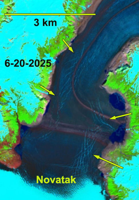
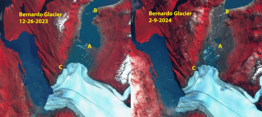
June 20, 2025 rifting of Novatak Glacier. The rifts represent places where water level change causes flexure of the glacier, leading to their formation and expansion. They are not related to flow, but to uplift and down fall.

Baird Glacier, Alaska Terminus Tongue Breaks Off April 2024

Baird Glacier terminus tongue gone in April 26, 2024 Landsat image. Red arrow indicates now joined 5 km2 proglacial lake. Yellow dots terminus of Baird and North Baird Glacier

Baird Glacier drains the west side of the Stikine Icefield in southeast Alaska. It is the only glacier of the Stikine Iceifield that did not retreat significantly from 1960-2010. Pelto et al (2013) predicted the onset of significant retreat of this glacier, which like Brady Glacier had been slow to begin retreat despite thinning that was evident when I visited the glacier in 1984. The proglacial lake that has emerged with retreat has an area of 3.25 km2 and the glacier retreat is 2800 m from 1990-2024. The North Baird Glacier separated from Baird Glacier in 2019, with a proglacial lake extending downvalley to the tongue of Baird Glacier that separated this lake from the Baird Glacier proglacial lake until April 2024.

Baird Glacier in Landsat images from 1990 and 2023 illustrating retreat and proglacial lake expansion.
Baird Glacier in false color Sentinel images from September 10 2023 and May 2 2024. Proglacial lake (PGL) expanded from 3.2 to 5.1 km². Tongue extending upvalley toward North Baird Glacier (NB) broke up in late April, yellow arrow.

Baird Glacier in false color Sentinel images from July 2022 and July 2023. Proglacial lake (PGL) expanded from 3.00 to 3.25 km² width of tongue extending upvalley toward North Baird Glacier (NB) has declined from 700 m to 400 m.

In 1990 the Baird Glacier was sitting on an outwash plain, with no lake at the terminus. The North Baird Glacier was 1 km wide where it joined the Baird Glacier. By 2015 the glacier has retreated 750 m and the lake (PGL) has an area of ~1 km².  In 2022 the glacier has retreated leading to a lake expansion to 3.00 km². In July 2023 the tongue of ice extending across the front of the North Baird Glacier valley has thinned 40% since July 2022. The tongue remained throughout 2023 into April of 2024 before breaking up. This leaves the main terminus of the glacier more vulnerable to further rapid calving retreat. Baird Glacier is catching up to the rest of the Stikine Icefield that has experienced significant retreat, Dawes GlacierPatterson Glacier and Great Glacier. With Sawyer Glacier retreating from tidewater in 2023.

Great Glacier Retreat 1965-2023 Leads to formation of “Great Lake”

Great Glacier terminus change from 1986-2022 illustrating lake expansion. Red arrow=1986 terminus location, Yellow arrow=2022 terminus location. Terminus has retreated 2.1 km during this time with the lake growing 15 km2.

Great Glacier is the largest outlet glacier of the Stikine Icefield feeding the Stikine River. The name came from the large expanse of the glacier in the lowlands of the Stikine River during the late 19th and early 20th century, that has now become a large lake. In 2023 I worked on a signage project for the Great Glacier Provincial Park with Hailey Smith, BC Park Ranger, documenting the changes in this glacier particularly since 1914.

The glacier filled what is now a large lake at the terminus of the glacier pushing the Stikine River to the east side of the valley. The Tahltan nation oral history relates when the glacier bridged the Stikine River and meet Choquette Glacier. In 1914 the glacier was easy to ascend from the banks of the Stikine River, the picture above is from the National Railroad Archive. By 1965 the new lake had formed, but the glacier still reached the far side of the lake in several places as indicated by the 1965 Canadian Topographic Map below. R. Patterson (Writer and Canadian Explorer 1898-1984) noted that Great Glacier came down onto the river flats, and displayed a 7 km front visible from the Stikine River.

Map of Great Glacier in 1965 illustrating the fringing lake.
Landsat images from 1990 and 2022, illustrating changes in the glacier and lake. The transient snowline is at ~900 m in both images.

A comparison of 1986, 1990, 2011 and 2022 illustrates the retreat. By 1986 the new lake had largely developed, and the glacier was beginning to retreat into the mountain valley above the lake. Retreat from the moraines of the late 19th century was 3200 m. By 2011 the glacier had retreated further into valley, 900 m retreat from 1986-2011. From 2011 to 2022 the glacier retreated another 1200 m. The lake has expanded to an area of 15 km2

A view of the glacier from across the lake today indicates the distance to the now valley confined glacier, and the trimlines of the former ice surface, yellow arrows in middle image The Great Glacier has one major tributary on the northeast tributary that is very low in elevation with a top elevation of 800 m. Given the regional snowline of 1100-1200 meters in the 1980s (Pelto, 1987) this is too low to retain snowcover through the summer and will lead to rapid progressive thinning. In 2018 and 2019 the highest observed snowlines in the region occurred, the snowline averaged 1500 m, leaving just 10% of the Great Glacier snowcovered. This is instead of the 60% needed to maintain equilibrium. Stikine Icefield outlet glaciers are all undergoing substantial retreats including Sawyer Glacier, Baird Glacier and Dawes Glacier.

Great Glacier snowline end of summer in 2018 and 2019 reached the highest levels observed at 1500-1600 m.

Bernardo Glacier, Chile Lake Drainage 2024-Retreat Continues

Bernardo Glacier in Sentinel images from Dec. 26, 2023 and Feb. 9, 2024 illustrating the drainage of the southern end of the proglacial lake by the northern terminus. The lake was full in 2021, partially drained by Oct. 2022, further drained by March 2023 and did not refill through Sept. 2023. The lake refilled between September and December 2023 . And drained again by Feb. 9,2024. Channel location appears to be at Point C. There is 9 km2 of exposed lake bed.

Bernardo Glacier in Sentinel images from Oct. 16, 2022 and Sept. 17, 2023 illustrating the drainage of the southern end of the proglacial lake by the northern terminus (N). The lake was full in 2021, partially drained by Oct. 2022, further drained by March 2023 and has not significantly refilled by Sept. 2023, still 8 km² of exposed lake bed. 

Bernardo Glacier in Landsat images from 1986 and 2021 illustrating retreat at the southern (S), middle (M) and northern (N) terminus respectively. Red arrows are 1986 terminus locations, yellow arrows are 2021 terminus locations. Separation from Tempano (T) occurs at southern terminus, while lake expansion occurs at M and N.

Retreat of Bernardo Glacier in Landsat images from 2003 and 2015.

In 1986 Bernardo the southern terminus of the glacier was in tenuous contact with Tempano Glacier. The middle terminus primarily ended on an outwash plain with a fringing proglacial lake developing. The northern terminus had retreated a short distance south from a peninsula that had acted as a pinning point. A small lake developed completely separating Bernardo Glacier and Tempano Glacier. By 1998 the northern terminus had retreated into the wider, deeper portion of the lake basin that was now filled with icebergs. In 2015 the northern terminus had retreated 3.5 km since 1986. By 2021 the northern terminus had retreated 4.1 km.  This led to a 7.8 km² lake expansion at the northern terminus, with a total lake area of 17.5 km².

On October 2, 2022 the water level had dropped some, with lake area falling slightly. The lake continued to fall through the summer season of 2023. The lake did not refill through the winter and into the spring, September 2023, with the lake having an area of 9.5 km², and 8 km² of lake bed still exposed. The lake did refill by December 2023, and then drained to an even greater extent then in 2023 as of Feb. 2024. Continue glacier thinning and retreat will reduce the ability of the glacier to continue to dam this lake. Gourlet et al (2016) identify Bernardo Glacier as having thinner ice than other large outlet glaciers such Jorge Montt or O’Higgins, which helps lead to rapid terminus change.

Southern Andean huemel an endemic deer on the foreland beyond Bernardo Glacier (Photograph from Eñaut Izagirre

Mount Everest Region Snow Line Winter 2024: Rises Above and Remains Above 6000 m

The snow line on Mount Everest Region glaciers on Feb. 11, 2024 indicated by yellow dots on the Landsat image. Note that Nangpa La and Nup La-two high passes (5800-5900 m) are both snow free. The average snow line is 6000 m.

The snow line on Mount Everest Region glaciers on Oct. 30, 2023 indicated by yellow dots on the Landsat image. Note that Nangpa La and Nup La-two high passes are both snow covered. The average snow line is 5700 m.
The snow line on Mount Everest Region glaciers on Nov. 15, 2023 indicated by yellow dots on the Landsat image. Note that Nangpa La and Nup La-two high passes are both snow covered. The average snow line is 5800 m.
The snow line on Mount Everest Region glaciers on Jan. 10, 2024 indicated by yellow dots on the Landsat image. Note that Nangpa La and Nup La-two high passes are both snow free. The average snow line is 5950 m.
Cumulative precipitation through the year at Everest Base Camp. The typical dry period begins in October and extends into Februrary, but this year is the lowest since the National Geographic Rolex Perpetual Planet weather station was installed.

In several recent years including Winter 2017/18, 2020/21 and 2023/24 the snow line has risen substantially on Mount Everest glaciers from October into the mid-winter period (Pelto et al 2022).. This indicates not just dry conditions, but conditions that allow significant ablation at the snow line, which has risen 150-300 m during each of these periods on the glaciers. The ablation can be from melting or as the case this winter sublimation, which can lead to losses up to 2.5mm/day (Tenzing Chogyal Sherpa et al 2023). When will snow finely cover the glaciers in the Everest region?