Storglombreen Glacier Loss, Norway

storg compare Landsat

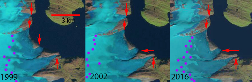
Landsat images from 199, 2002 and 2016 comparing glaciers draining into Storglomvatnet.  Red arrows indicate 1999 terminus locations, purple dots the snowline. 

Storglomvatnet has several glacier that terminated in the lake in 1999, Storglombreen Nord, Sorglombreen Sud and Tretten. This lake is the main reservoir, 3.5 billion cubic meters that feeds the 350 MW Svartisen Hydropower plant. The lake has an elevation of 585 m, while the power plant is at sea level. Paul and Andreassen,(2009)  examined glacier area and found overall almost no areal extent change from 1968-1999 of Svartisen region glaciers, including the three examined here.  Engelhardt et al (2013), note this was due to positive trends of winter balance between 1961 and 2000, which have been followed by a remarkable decrease in both summer and winter balances leading to an average annual balance of –0.86±0.15 m w.e.a–1 between 2000 and 2010 .Since 1999 there have been changes. The Norwegian Glacier Inventory  and the online digital atlas use this 1999 imagery and indicate glacier area  for Storglombreen Sud at 15.9 km2, for Storglombreen Nord  at 41.2 km2 and Tretten-nulltobreen at 5.9 km2.

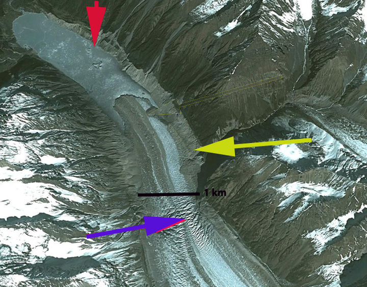
In 1999 each of the glaciers reaches the lake shore at 585 m in four separate terminus fronts. The snowline in 1999 is at 1150 m. In early August 2002 the termini still reach the lake shore and the snowline is higher at 1250 m.  In 2001, 2002 and 2003 mass balance measurements by the Norwegian Water Resources and Energy Directorate, indicate the snowline reached the top of the glacier at 1580 m. In 2016 the glacier termini no longer reach the lake shore and the snowline is again at 1150 m. It is evident in the Landsat image above that Storglombreen Sud and Tretten-nulltobreen no longer reach the lake shore, the southern most and northern most termini and arrows.  The two termini of Storglombreen Nord no longer reach the lake, though this requires higher resolution Sentinel 2 images to illustrate. Retreat of Tretten-nulltobreen from 1999-2016 has been 200 m, of Storglombreen Sud 250 m and of Storglmbreen Nord 100-200 m. There was limited calving into the lake and the retreat from the lake will not significantly alter the retreat rate of the glacier.  The high snowlines of recent years will lead to continued retreat. The retreat here is much less than on Engabreen which shares a divide with Storglombreen Nord, Flatisen  or Blåmannsisen.

svartisen west

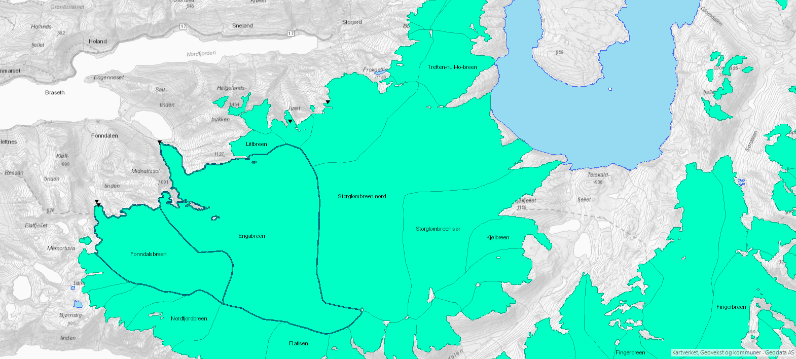
Map of the glaciers in the region from the Norwegian Glacier Inventory online map application, based on 1999 images.

storg 2016 sentinel

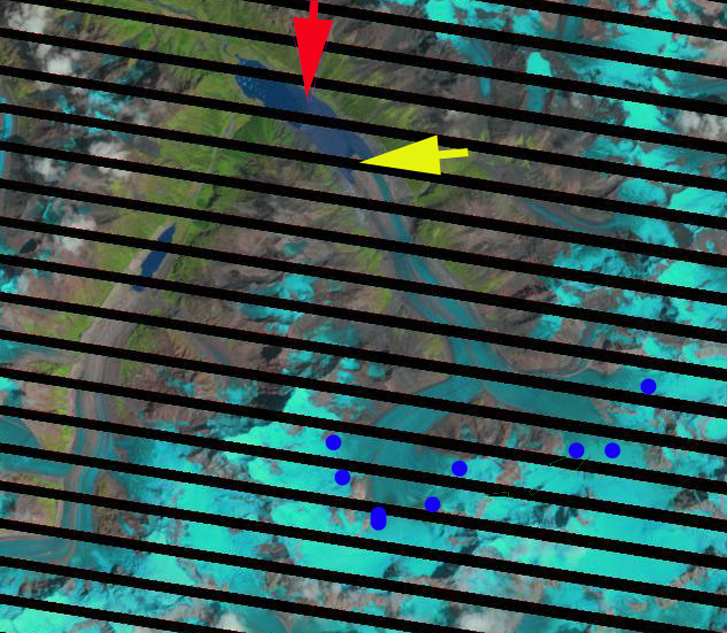
Sentinel 2 image of the glaciers of Storglomvatnet from August 2016.  Notice that none of the termini reach the lake shore. 


Winsvold, Andreassen and Kienholz (2014)

Jiongla Glacier, China Rapid Retreat 1988-2015

jionla compare

Jiongla Glacier retreat right and Jiangyegong Glacier left retreat from 1988 to 2015 in Landsat images.  The red arrow is the 1988 terminus and the yellow arrow the 2015 terminus. Jiongla Glacier retreated 3200 m and Jiangyegong Glacier 800 m. 

Jiongla Glacier is at the northern boundary of the Brahmaputra River Basin at the east end of the Nyainqentanglha Shan. The glacier drains the western slopes of Koma Kangri Peak and ends in a lake before feeding into the Parlung Zangbo and then Yarlung Tsanpo. his glacier feeds the Parlung Zangbo which is the site of numerous planned hydropower projects, last image, before joining the Yarlung Tsanpo which becomes the Brahmaputra River. The Zangmu Dam went online in 2015, this hydropower facility will produce 2.5 billion kilowatt-hours of electricity a year. In a study by Tobias Bolch et al (2010) in the western Nyainqêntanglha Mountains glacier area decreased by 6% between 1976 and 2001 and continued to shrink from 2001–2009. Li et al (2010) examined glacier change over the last several decades in China and found ubiquitous glacier retreat and commonly lake formation as glaciers retreated. Ninglian and Shichang (2014) in the China National Report on Cryospheric Sciences noted a loss in glacier area of 15 to 17 % in the region. Here we examine satellite imagery from 1988, 2000, 2009, 2010, 2011 and 2015. The red arrow denotes the 1988 terminus and the yellow arrow the 2011 terminus.

In 1988 the lake where Jiongla Glacier ends is at 2 km long. By 2000 the glacier has retreated 1300 meters. In the 2003 terminus closeup that indicates vigorous flow through an icefall, purple arrow, 2 km behind the terminus. This indicates the lake will end before this point and the glacier does not have a substantial stagnant terminus tongue. By 2011 the lake is 4 km long, a 2 km retreat in 20 years. There are icebergs visible in the lake particularly in the 2003, 2009 and 2011 images indicating that this one a key reason for rapid recent retreat. In reviewing the satellite images for the region cloud cover made it difficult to find imagery near the end of the melt season. By 2015 the lake is 5200 m long indicating a 3200 m retreat from 1988-2015.  The terminus is now within 500 of the increase in surface slope that suggests the end of the lake, and likely the end of the current rapid retreat. The 2011 image is from near the end of the melt season and indicates a snowline at 5150 m, blue dots, this is too high for equilibrium, with limited glacier area above 5500 m and the terminus at 4000 meters. This suggests that retreat will continue.   The retreat here is similar to that of Thong Wuk Glacier and Requiang Glacier.

The neighboring Jiangyegong Glacier has experienced an 800 m retreat from 1988 to 2015.  This terminus remains low slopes and heavily debris covered. The debris will slow the retreat, while the low slope indicates the lake can continue to expand enhancing retreat.  This also suggests the rate of retreat will soon slow.T
jiongla2000

Landsat image 2000 with the yellow arrow indicating the 2011 terminus position and the red arrow the 1988 terminus position.

jiongla terminus2003 Google Earth Image

jiongla 2011

Landsat image 2011 with the yellow arrow indicating the 2011 terminus position and the red arrow the 1988 terminus position.


Yarlung Tsangpo HPP

Hydropower dams completed, under construction and proposed. 


Bridge Glacier Retreat Acceleration, BC, Canada

Bridge Glacier is an 17 km long outlet glacier of the Lilloet Icefield in British Columbia. The glacier ends in a rapidly expanding glacial lake with 1100 meters of retreat from 2005-2010. This 200+ m per year retreat is a substantial acceleration over the observed retreat rate of 30 m per year from 1981-2005 by Allen and Smith (2007). They examined the dendrolchronology of Holocene advances of the glacier and found up to 2005 a 3.3 kilometer advance from the primary terminal moraine band, with the most extensive advances being early in the Little Ice Age. The glacier currently ends at 1400 m and in 2010 had a late summer snowline of 2000 m. . The glacier terminus in 1970 is shown in map form, and is indicated by a brown line. The 2003 terminus position from a Landsat image, second image, is next with a red line marking the terminus. The normal Google Earth image, third image, is from 2005 and has a green line. An image from Geoeye from August 2010, last image, terminus purple line indicates the rapid acceleration of retreat. Retreat from 1970-2003 was 48 m per year. The retreat from 2003 to 2010 is 1400 meters, 200 m per year. This continued retreat and area loss will lead to glacier runoff decline in summer. This is crucial to the large Bridge River Hydro complex. This complex managed by BC Hydro can produce 490 MW of power. Stahl et al (2008) note in their modeling study of the glacier that ,”The model results revealed that Bridge Glacier is significantly out of equilibrium with the current climate, and even when a continuation of current climate is assumed, the glacier decreases in area by 20% over the next 50 to100 years. This retreat is accompanied by a similar decreasein summer streamflow.” This parallels our findings on the Skykomish River in the North Cascades, Washington Pelto (2008) and Pelto (2011).