Field Glacier, Alaska Retreat, Separation and Rapid Lake Development 1984-2021

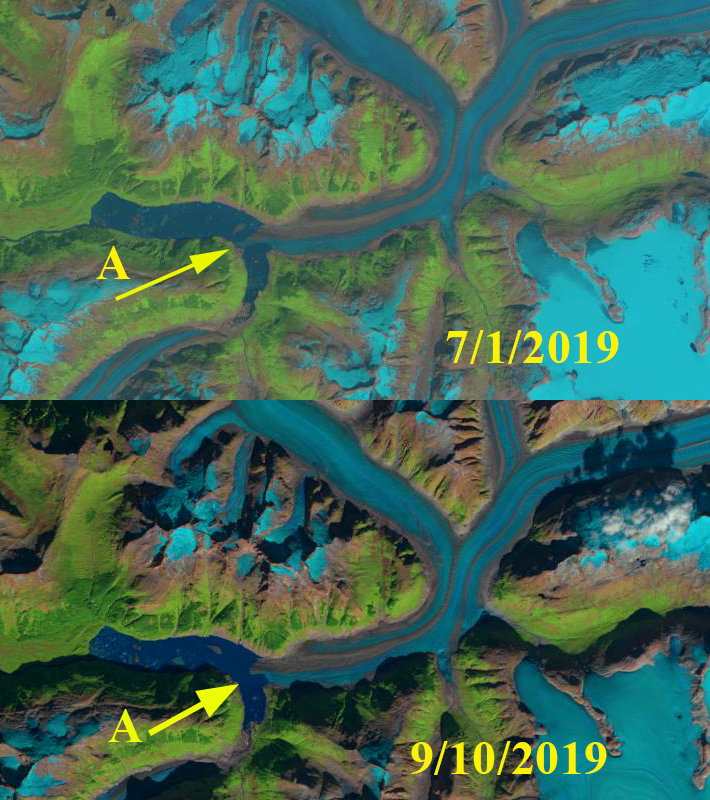
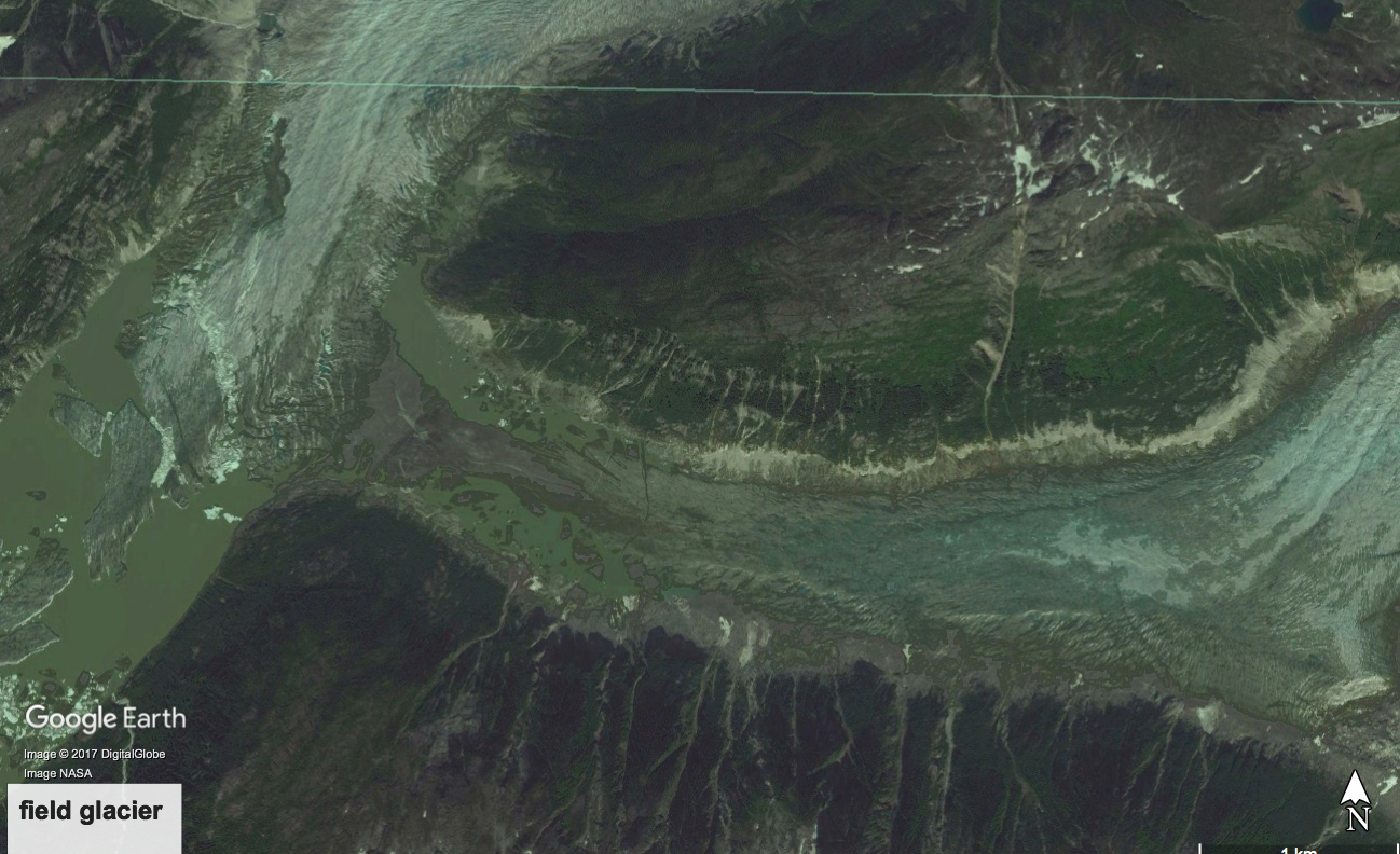
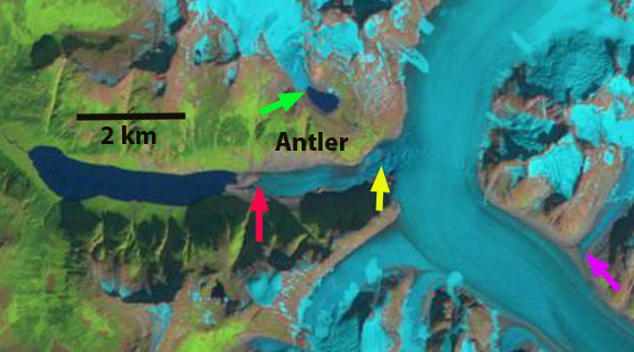
Field Glacier on Aug. 31, 2021 in a Sentinel image. Note former glacier junctions A and B where the glacier has separated this century. The 7.5 km2 lake did not exist when I first visited this glacier.

The Field Glacier flows from the northwest side of the Juneau Icefield, and is named for Alaskan glaciologist and American Geographical Society leader William O. Field. Bill along with his work around Glacier Bay helped initiate the Juneau Icefield Research Program, which Maynard Miller then ably managed for more than 50 years. The JIRP program is still thriving today led by Seth Campbell. In 1981, as a part of JIRP, I had my first experience on Field Glacier completing a snowpit in its upper accumulation area. In the summer of 1983 I met with Bill to discuss where to setup a long term glacier mass balance program. I ended up selecting the North Cascade Range. In 1984 we skied back to the same snowpit site on Field Glacier, finding 3.8-4.1 m of retained snowpack in crevasses. At the end of our 11th field season in the North Cascade Range I spent a couple of nights at Austin Post’s (USGS) house and he reviewed his choice for a glacier to name after Bill, who had passed earlier that month. This was truly a remote area, which was why it had remained unnamed.

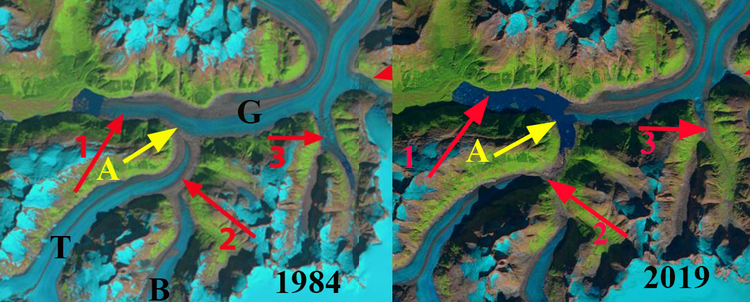
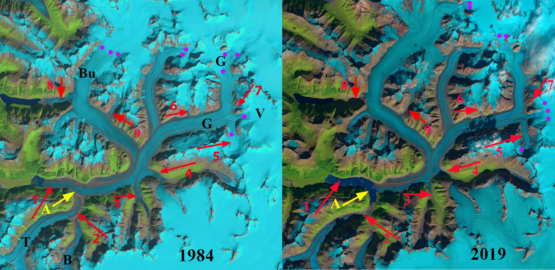
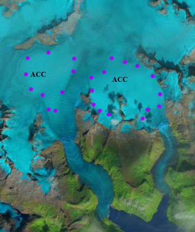
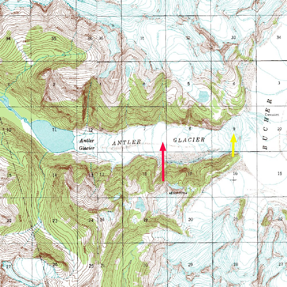
In 1984 the glacier began from the high ice region above 1800 meters, with two main branches joining at Point A and one significant tributary joining from the northern branch at Point B. There are icefalls near the snowline at 1350 meters on both the southern branch and the tributary entering at Point B. In 1984 the glacier descended the valley ending at 100 meters on the margin of an outwash plain. The meltwater feeds the Lace River which flows into Berners Bay. This post focusses on the changes from 1984-2021 using primarily Landsat imagery.

Field Glacier in Landsat images from 1984 and 2021 illustrating lake development, glacier separation at Point A and B and progressive detachment/separation at Point C,D and E. Purple dots indicate the snowline elevation at 1350-1400 m.

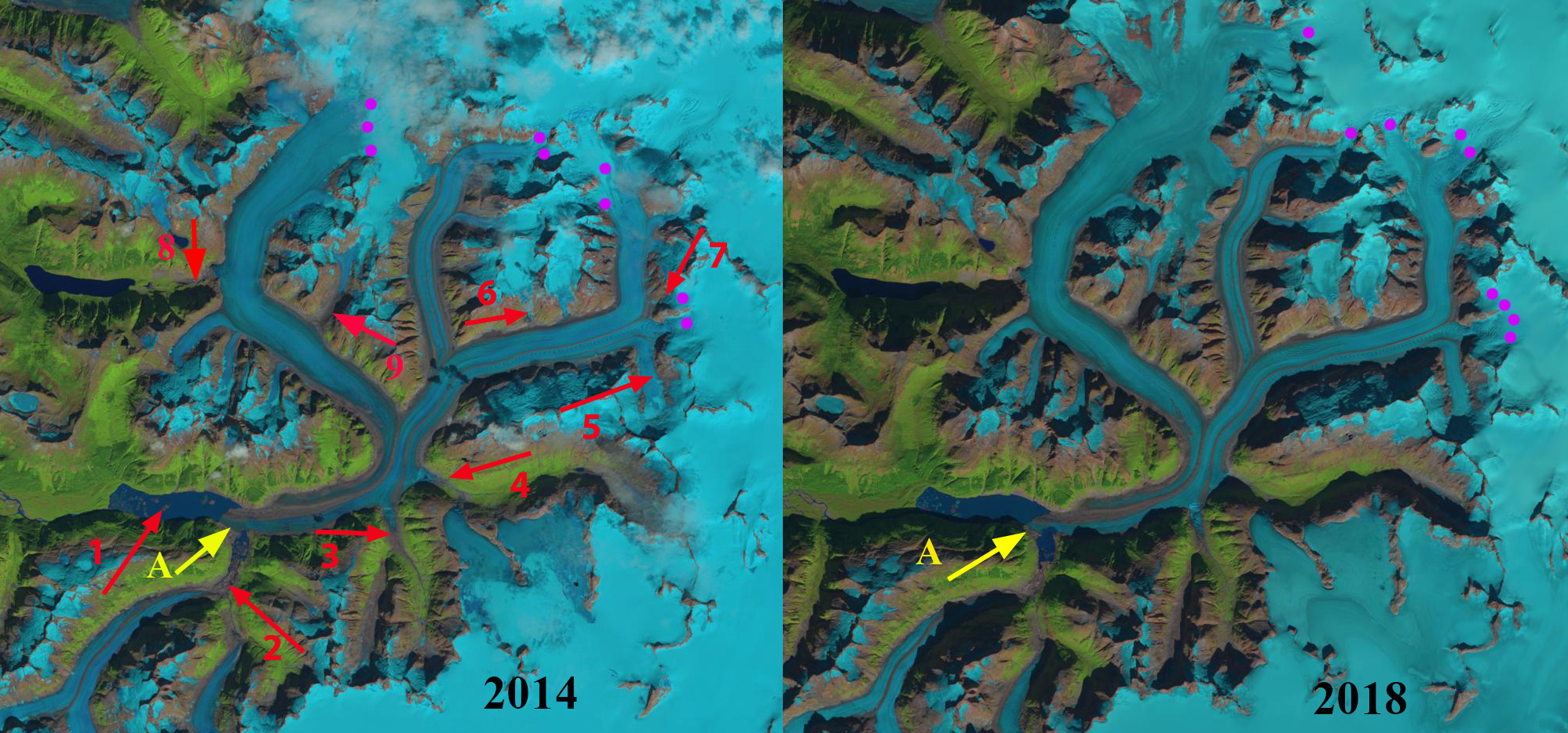
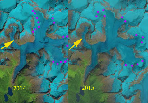
The USGS map from 1948 imagery and the 1984 imagery indicate little change in the terminus position. There is a narrow fringing proglacial lake along the southern edge of  the terminus in 1984 with most of the margin resting on the outwash plain. In 1997 the proglacial lake was still a narrow fringing lake, though clearly poised to expand as it extended nearly the full perimeter of the terminus. By 2006 the proglacial lake at the terminus averaged 1.6 km in length, with the east side being longer. There were several small incipient lakes forming at the margin of the glacier above the main lake. In 2009 the lake had expanded to 2.0 km long and was beginning to incorporate the incipient lake on the west side of the main glacier tongue. There was also a lake on the north side of this tributary. This lake was noted as being poised to soon fill the valley of the south tributary and fully merge with the main lake at the terminus (Pelto, 2017).   In 2013 Landsat imagery indicates the fragile nature of the terminus tongue that was about to further disintegrate, retreat from 1984-2013 was 2300 m and the lake had an area of 4.0 km2 (Pelto, 2017). This disintegration led to the separation of the two branches by 2017.

In 2021 the Field Glacier has two main branches are separated by 4 km, Point A. The tributary at Point B is also separated, no longer joining the main glacier. There is another separation imminent at the junction-Point E, 5 km of this former tributary.  At Point C and D progressive detachment of smaller tributaries are evident. From 1984 to 2021, Field Glacier has experienced a retreat of 5500 m of the southern branch and 4100 m of the northern branch. The lake has expanded to 7.5 km2.  Fringing lake on the northern branch indicates the lake will expand at least another 1 km. For the southern branch the glacier is close to what will be the lake margin. The record snowline elevation on the icefield in 2018 and 2019 (Pelto, 2019), has led to a continuation of the rapid mass balance loss, retreat, and lake development at Field Glacier. This glacier is experiencing retreat and lake expansion like several other glaciers on the Juneau Icefield, Gilkey Glacier, Llewellyn Glacier, and Tulsequah Glacier (Pelto, 2017).

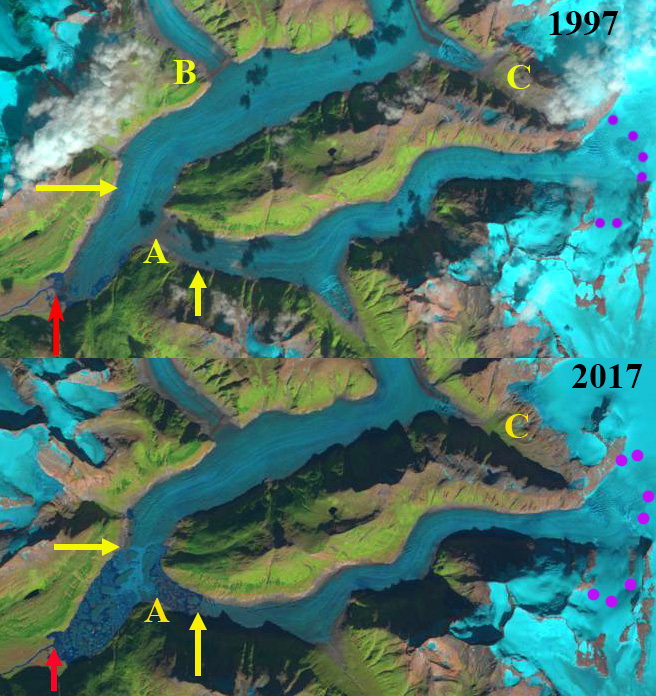
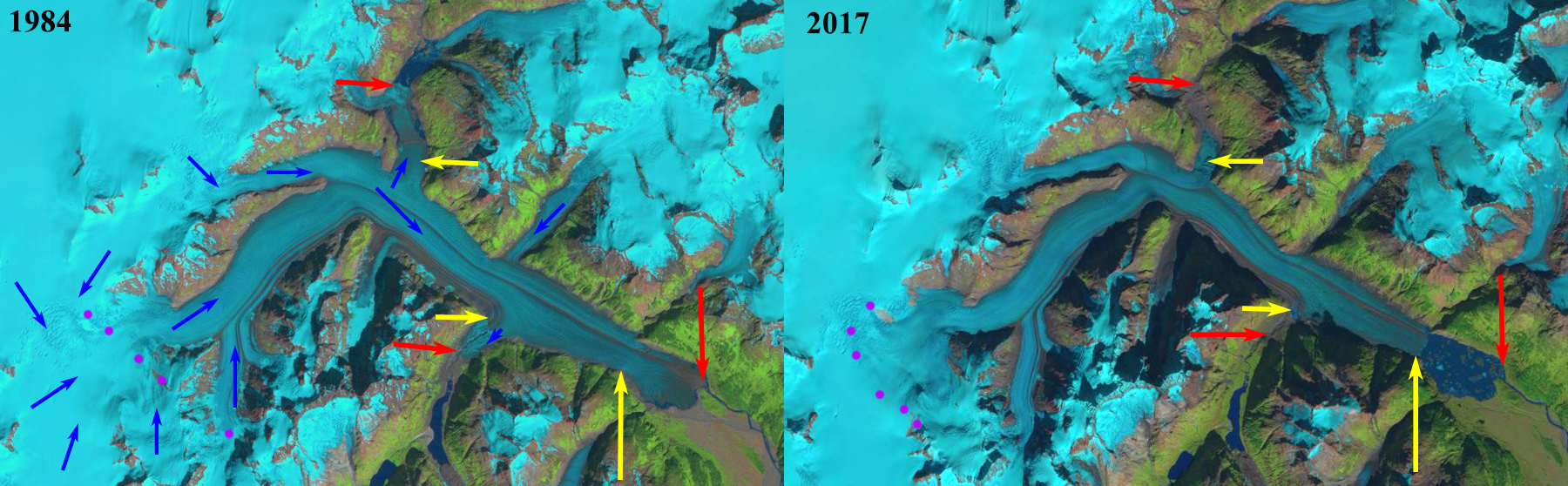
Field Glacier in Landsat images from 1997 and 2017 illustrating lake development, glacier separation at Point A and B and progressive detachment/separation at Point C,D and E.


Field Glacier terminus in Landsat images from 1984 and 2013, dots indicate terminus, with pink arrows in 2013 indicating where marginal lakes have developed.

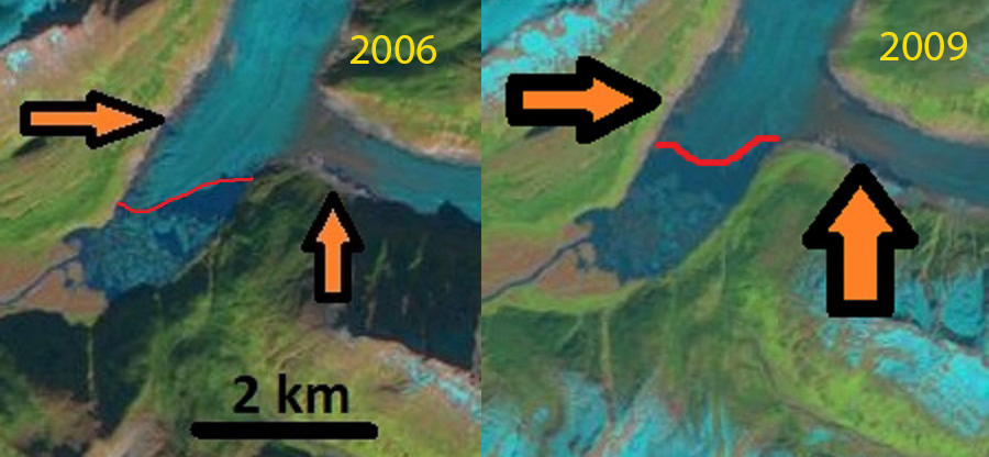
Field Glacier terminus in Landsat images from 2006 and 2009, red line is terminus with orange arrows indicating fringing lake development.

Taku Glacier, Alaska Retreat Begins: A Two Century Long Advance Reversed by Climate Change

Taku Glacier in 2016 and 2019 Sentinel 2 images.  The Hole in the Wall Tributary  (HW) is upper right, Taku Glacier main terminus (MT). Yellow line is the 2016 terminus location.  The arrows denote locations where thinning is apparent as the area of bare recently exposed bedrock has expanded. A closeup is below.  Pink and brown areas between blue ice and yellow line in 2019 indicates retreat.

The Taku Glacier is the largest outlet glacier of the Juneau Icefield in Alaska.  Taku Glacier began to advance in the mid-19th century and this continued throughout the 20th century. At first observation in the 19th century the glacier was calving in deep water in a fjord.   It advanced 5.3 km between 1890 and 1948 moving out of the fjord into the Taku River valley, see maps below (Pelto and Miller, 1990).  At this time calving ceased resulting in positive mass balance without the calving losses.  The glacier continued to advance 2.0 km from 1948-2013 (Pelto, 2017). The advance was paralleled by its distributary terminus, Hole in the Wall Glacier.  This advance is part of the tidewater glacier cycle (Post and Motyka, 1995), updated model by Brinkerhoff et al (2017)  .  At the minimum extent after a period of retreat the calving front typically ends at a point of constriction in fjord width and or depth that limits calving.  With time sedimentation in front of the glacier reduces water depth and calving rate, allowing the glacier to begin to advance. In the case of the Taku Glacier after a century of advance the glacier had developed a substantial proglacial outwash and moraine complex that had filled in the fjord and the glacier was no longer calving, images below from 1961 and 1981 illustrate this.  This allowed the advance to continue through the rest of the 20th century and into the 21st century.  The slowing of the advance in the latter half of the 20th century has been attributed to the impedance of the terminus outwash plain shoal (Post and Motyka, 1995; Pelto and Miller, 1990). There is a concave feature near the terminus with an increase in crevassing where the push impacts flow dynamics as seen at black arrow in 1975 and 1998 images below. In 1980’s the Taku Glacier’s accumulation area ratio was still strong enough for Pelto and Miller (1990) to conclude that the Taku Glacier would continue to advance for the remaining decade of the 20th century, which it did.

Beginning in 1946 the Juneau Icefield Research Program began annual mass balance measurements that is the longest in North America. In conjunction with JIRP and its first director Maynard Miller we compiled and published an annual mass balance record in 1990.  From 1990 to the present in conjunction with JIRP and Chris McNeil we have continued to compile and publish this annual mass balance record (Pelto et al 2013).  This mass balance record has been updated as of April 2020 (McNeil et al 2020). Much of the remarkable data record of JIRP has this month been made accessible to the public, particularly through the efforts of Seth Campbell, JIRP director, Scott McGee, survey team director and Chris McNeil, mass balance liaison with USGS.

The ELA in 2018 and 2019 in Landsat images, purple dots indicate the record high snowlines for the 1946-2019 period that occurred both in 2018 and again 2019, Pelto (2019)  

Taku Glacier is one of the thickest known alpine temperate glacier, it has a maximum measured depth of 1480 m and its base is below sea level for 40-45 km above the terminus (Nolan et al 1995).   Moytka et al (2006) found that the glacier base was more than 50 m below sea level within 1 km of the terminus, and had deepened substantially since 1984. This suggests a very long calving retreat could occur. The glacier had a dominantly positive mass balance of +0.42 m/year from 1946-1988 and a dominantly negative balance since 1989 of  -0.34 m/year (Pelto et al 2013). . This has resulted in the cessation of the long term thickening of the glacier.  On Taku Glacier, the annual ELA (end of summer snowline altitude) has risen 85 m from the 1946-1988 period to the 1989-2019 period.  During the 70+ year annual record the ELA had never exceeded 1225 m until 2018, when it reached 1425 m ( Pelto (2019) ).  In 2019 the ELA again has reached a new maximum of 1450 m (see above images). Contrast the amount of the glacier above the snowline in 2018 and 2019 to other recent years that had more ordinary negative balances (see Landsat images below).

In 2008 and 2012 JIRP was at the terminus, creating the map below.  There was no change at the east and west side of the margin since 2008 and 55 to 115 m of advance closer to the center. The glacier did not advance significantly after 2013, and did not retreat appreciably until 2018. The Taku Glacier cannot escape the result of three decades of mass losses, with the two most negative years of the record being 2018 and 2019. The result of the run of negative mass balances is the end of a 150+ year advance and the beginning of retreat. Sentinel images from 2016 and 2019 of the two main termini Hole in the Wall Glacier right and Taku Glacier left. The yellow arrows indicate thinning and the expansion of a bare rock trimline along the margin of the glacier. The Hole in the Wall terminus has retreated more significantly with an average retreat of ~100 m.  The Taku main terminus has retreated more than 30 m along most of the front.  A terminus change record has been published as of April 2020 (McNeil et al 2020).

The retreat is driven by negative balances, mainly by increased surface melt.  The equilibrium flow of the Taku Glacier near the long term ELA for the 1950-2005 period was noted by Pelto et al (2008). This occurred during a period of glacier thickening, average profile velocity was 0.5 md-1  (Pelto et al 2008). Since 1988 the glacier has not been thickening near the snowline as mass balance has declined slightly (Pelto et al 2013). The remarkable velocity consistency measured by JIRP surveyors led by Scott McGee each year at profile 4 has continued.  It is below this profile that surface ablation has reduced the volume of ice headed to the terminus.

All other outlet glaciers of the Juneau Icefield have been retreating, and are thus consistent with the dominantly negative alpine glacier mass balance that has been observed globally (Pelto 2017).  Now Taku Glacier joins the group unable to withstand the continued warming temperatures.  Of the 250 glaciers I have personally worked on it is the last one to retreat. That makes the score climate change 250, alpine glaciers 0.

1890 United States Coast Guard Map indicating deep water in the fjord in front of Taku Glacier. 


Map of terminus change from Lawrence (1950).


Taku Glacier aerial photograph from US Navy in 1948.  Still minor calving on right (east side).


Taku Glacier in 1961 photograph indicating calving had ended. 


Taku Glacier in 1981 photograph with the well developed outwash plain (Pelto).


Map of Terminus Change from Miller and Pelto (1990)


Maynard Miller image of Taku Glacier and Norris Glacier in 1975, not concave flexure point at black arrow.


Photograph of Taku Glacier and Norris Glacier in 1998, not concave flexure point at black arrow (Pelto)


JIRP terminus survey map of 2008 and 2012 surveys. 


Equilibrium line altitude (ELA) from 1946-2019.


ELA in 2013, 2014, 2015 and 2017 in Landsat images.


This is a view across the glacier accumulation area that until 2018 had always been snowcovered at the end of summer (Pelto).


Gilkey Glacier Retreat Leads to Rapid Lake Expansion in 2019

Gilkey Glacier in 1984 and 2019 Landsat images indicating retreat of 4300m, tributary separation and 5 km2 lake expansion. A=Terminus tongue, B=Battle Glacier, G=Gilkey Glacier and T=Thiel Glacier.

Gilkey Glacier draining the west side of the Juneau Icefield has experienced dramatic changes since I first worked on the glacier in 1981.   The Gilkey Glacier is fed by the famous Vaughan Lewis Icefall at the top of which Juneau Icefield Research Program (JIRP) has its Camp 18 and has monitored this area for 70 years. Here we examine the changes using Landsat images from 1984, 2014, 2018 and 2019.  Landsat images are a key resource in the examination of the climate change response of these glaciers (Pelto, 2011). The August 17th 1984 image is the oldest high quality Landsat image, I was on the Llewellyn Glacier with  JIRP on the east side of the icefield the day this image was taken. JIRP was directed by Maynard Miller at that time and by Seth Campbell now.

In 1984 Gilkey Glacier terminated in a new proglacial lake that had  and area of 1.5 km2 (#1). At #2 Thiel and Battle Glacier merged and then joined Gilkey Glacier. Arrow #3 and #4 indicates valleys which tongues of the Gilkey Glacier flow into, at #3 the glacier extended 1.6 km upvalley.  At arrow #4 the glacier extended 1.5 km up Avalanche Canyon.  At #6, #7 and #9 tributaries flow into the Gilkey Glacier.  At #8 Antler Glacier is a distributary glacier terminus that spilled into a valley terminating short of Antler Lake.

By 2014 the proglacial lake had expanded to 3.65 km2 as the glacier has retreated 3200 m.  Thiel and Battle Glacier have separated from Gilkey Glacier and from each with a retreat of 2600 m for Thiel Glacier and 1400 m for Battle Glacier. The glacier no longer flows into the valley at #4. Tributaries at #6 and #9 no longer reach Gilkey Glacier.  At #7 there is not a direct flow connection, but is still an avalanche connection.  At #8 Antler Glacier has retreated 2200 m.

In 2018 and 2019 the snowline on the Juneau Icefield has been the highest of any year since observations began in 1984.  This will accelerate mass loss and lead to continued extensive retreat.  In 2018 the snowline was at 1600-1650 m on Sept. 16. In 2019 the snowline on Gilkey Glacier was 1650-1700 m on Sept. 10.  In July of 2019 the terminus tongue of the glacier reached across the junction of the Gilkey and Battle Valley, separating the two proglacial lakes.  By September 10, the glacier tongue had broken off leading to the two lakes joining expanding the size of the proglacial lake to 6.5 km2. The terminus has retreated 4300 m since 1984, while the lake has increased in size by more than 400%. The retreat will continue leading to additional lake expansion just as is occurring at Meade and Field Glacier.

The expansion of Gilkey Lake into the Battle Valley in 2019 Landsat images.

Gilkey Glacier in 1984 and 2019 Landsat images indicating retreat of 4300m, tributary separation and 5 km2 lake expansion. A=Terminus tongue, B=Battle, Bu=Bucher, G=Gilkey, T=Thiel, V=Vaughan Lewis. Snowline=purple dots.

Gilkey Glacier in 2014 and 2018 Landsat images indicating retreat, snowline elevation and lake expansion. 


Tulsequah Glacier, British Columbia 2900 m retreat 1984-2017

Tulsequah Glacier in 1984 and 2017 Landsat images.  The 1984 terminus location is noted with red arrows for the main and northern distributary tongue, southern distributary red arrow indicates lake margin.  The yellow arrows indicate the 2017 glacier terminus locations. The retreat of 2900 m since 1984 led to a lake of the same size forming. Purple dots indicate the snowline.

Tulsequah Glacier, British Columbia is a remote glacier draining from the Alaska-Canada boundary mountains of the Juneau Icefield. It is best known for its Jökulhlaups from lakes dammed by Tulsequah Glacier in northwestern British Columbia, Canada (Neal, 2007). The floods pose a hazard to the Tulsequah Chief mining further downstream. The continued retreat of the main glacier at a faster rate than its subsidiary glaciers raises the potential for an additional glacier dammed lakes to form. The main terminus has disintegrated in a proglacial lake. Retreat from 1890-1984 had been much slower than the last thirty years. This glacier feeds the Taku River which has seen a significant decline in salmon in the last decade (Juneau Empire, 2017). Here we utilize Landsat images from 1984-2017 to illustrate changes in this glacier, updating the retreat noted by Pelto (2017).

As part of the onoging Juneau Icefield Research Program we completed extensive snow pack measurements in the upper reach of the glacier in 1981-1984 and found that snow depths in August near the end of the melt season between 1700-2000 meters averaged 4-6 meters. This high snowfall accumulation is also indicated by modelling in a recent publication, in a project led by Aurora Roth, @ UAlaska-Fairbanks, that I participated in.

In 1984 the glacier has a low sloped terminus tongue with a narrow fringe of water indicating the initial formation of a lake. The northern distributary terminus extends 3.5 km north from the main glacier.  The southern distributary tongue that blocked the main glacier dammed lake in the past, extending south from the main glacier, now terminates near the main glacier, with the red arrow indicating the southern end of the lake basin. The snowline is at 1300 m. By 2001 the fringing lake extends along the margin for 3 km and is 200-400 m wide.  The northern distributary terminus extends just 500 m from the main glacier.  The southern distributary glacier dammed lake still forms as indicated by icebergs. The snowline is at 1450 m. The snowline is at ~1300 m. In a 2007 Google Earth image the collapsing terminus is still connected to the main glacier. By 2015 the terminus tongue has collapsed with the new proglacial lake still filled by numerous icebergs.  The southern distributary tongue no longer has icebergs indicating lake formation at this location. By 2017 the terminus has retreated 2900 m since 1984, with a new 3 km long proglacial occupying the former glacier terminus. Also note the first tributary entering the glacier from the north in 1984 no longer reaches the glacier in 2017.  The northern distributary tongue has icebergs indicating lake formation still occurs.    The snowline in 2017 is at 1450 m.  The issue driving the retreat is that the equilibrium line where melting equals accumulation and bare glacier ice is exposed has risen and is now typically at 1400 meters. Berthier et al (2018), in a paper I had the pleasure of reviewing, indicate thinning from 2000-2016 greater than 2.5 m per year below 1000 m, with some thinning extending right to the crest of the glacier in all but the northwest corner.  This will drive continued retreat. This retreat is not as spectacular as at Porcupine Glacier to the south. This is not unlike the situation at the Gilkey Glacier just delayed.

Tulsequah Glacier in 2001 and 2015 Landsat images.  The 1984 terminus location is noted with red arrows for the main and northern distributary tongue, southern distributary red arrow indicates lake margin.  The yellow arrows indicate the 2017 glacier terminus locations. Purple dots indicate the snowline.

2007 Google Earth image indicating the fialing connection of the main glacier to the terminus tongue.

Field Glacier, Alaska Retreat, Leads to Glacier Separation

Field Glacier in Landsat images from 1984, 2013 and 2017.  The red arrow indicates the 1984 terminus, the yellow arrows the 2013 terminus and the yellow dots the 2017 terminus.  The purple arrows indicate developing lateral margin lakes in 2013 and purple dots the transient snowline.

The Field Glacier flows from the northwest side of the Juneau Icefield, and is named for Alaskan glaciologist and American Geographical Society leader William O. Field. Bill also helped initiate the Juneau Icefield Research Program, which Maynard Miller then ably managed for more than 50 years. The JIRP program is still thriving today. In 1981, as a part of JIRP, I had my first experience on this glacier. It was early August and there was new snowfall everyday that week. Jabe Blumenthal, Dan Byrne and myself undertook a ski journey to examine the geology on several of the exposed ridges and peaks, note the burgundy line and X’s on image below. This was truly a remote area. The glacier begins from the high ice region above 1800 meters, there are several icefalls near the snowline at 1350 meters, and then it descends the valley ending at 100 meters. The runoff descends the Lace River into Berners Bay.This post focuses on the significant changes occurring at the front of the Field Glacier. The development of a proglacial lake at the terminus is accelerating and spreading into the main southern tributary of the glacier.  In 2013 it was observed that the lake was going to quickly expand and develop a second arm in that valley, as the two main tributaries separate.

The USGS map from 1948 imagery and the 1984 imagery indicate little change in the terminus position, with only a small lake at the terminus in 1984 with most of the margin resting on the outwash plain.  The Field Glacier by 2006 had developed a proglacial lake at the terminus that averaged 1.6 km in length, with the east side being longer. There are several small incipient lakes forming at the margin of the glacier above the main lake, each lake indicated by black and orange arrow. In 2009 the lake had expanded to 2.0 km long and was beginning to incorporate the incipient lake on the west side of the main glacier tongue. There was also a lake on the north side of this tributary. This lake was noted as being poised to soon fill the valley of the south tributary and fully merge with the main, as yet unnamed lake at the terminus, maybe this should be Field Lake.   In 2013 Google Earth imagery indicates the fragile nature of the terminus tongue that is about to further disintegrate. From 1984 to 2017 Field Glacier has experienced a retreat of 5300 m of the southern branch and 4050 m of the northern branch. This glacier is experiencing retreat and lake expansion like several other glaciers on the Juneau Icefield, Gilkey GlacierEagle Glacier, and Antler Glacier.

.

Development of proglacial lakes from 2006 to 2009.

Terminus noted for 1984 and 2011 and the snowline in 2011.  JIRP camp locations noted by X’s.

2013 Google Earth image of the terminus. Many small icebergs already separating.


Llewellyn Glacier, BC Proglacial Lake Merging From Retreat

Llewellyn Glacier comparison in 1984 Landsat and 2016 Sentinel images.  Red arrows the 1984 terminus locations for proglacial lakes A-D, yellow arrows the 2016 terminus locations for A and B. Point E was the peninsula separating proglacial lakes A and B, which are now joined due to glacier retreat. 

The second largest glacier of the Juneau Icefield is the Llewellyn Glacier which is in British Columbia. The Juneau Icefield Research Program has a research camp, C-26 on this glacier and it is the typical exit route from the icefield at the end of the field season.  Here we examine changes in the terminus from 1984-2016 as a result of higher snowlines indicative of an expanded ablation zone and negative mass balance. 

I first visited the glacier in 1981 and I was also on the icefield in 1984 when the Landsat image was acquired that is used as the start point for comparison. In 1984 the glacier had several termini ending in proglacial lakes A-D. We exited the glacier on the west side of proglacial lake A in 1984 onto a proglacial outwash plain referred to as the ball bearing highway.   At Point B the terminus ended in a deeper wider proglacial lake than Lake A. At Point C and D the glacier ended in a series of small lakes.  Point E is the peninsula separating proglacial lake A and B in 1984. Proglacial Lake B had a surface water level 10-15 m higher than Lake A in 1984. In 2011 the glacier still reached Point E  separating the two lakes, which still had different water levels. In 2013 the gap first opened between the two lakes, and the water level fell in Lake B. In the summer of 2016 and spring of 2017 the gap has persisted and widened to  150 m.  From 1984 to 2016 the terminus in Lake A has retreated 1300 m, the terminus at Lake B 2100 m, terminus at Point C 800 m and terminus at Point D 1100 m. The narrow tongue of ice at the pink arrow will not survive long. The crevasse pattern suggests the glacier has another 1.5- 2 km to retreat before lake development will cease. 

The snowline during the 1998-2013 period averaged 1900 m too high for an equilibrium balance.  In a sequence of images from 2013 illustrates the rise is snowline from  1450 m on June 21,  to 1780 m on August 1 and  1810 m on Sept. 2.   The persistently higher snowlines since 1990 have led substantial thinning, Melkonian et al. (2013) note thinning of more than 1 m per year at the terminus diminishing to little change above 1500 m from 2000-2009. This will drive continued retreat, supplemented by calving into the still growing proglacial Lake at Point A and B.  The retreat of this glacier follows that of other glaciers of the Juneau Icefield including nearby Tulsequah Glacier, noted by Pelto et al (2013) and Pelto (2016) .

[ngg_images source=”recent_images” display_type=”photocrati-nextgen_basic_slideshow” gallery_width=”600″ gallery_height=”400″ cycle_effect=”fade” cycle_interval=”5″ show_thumbnail_link=”1″ thumbnail_link_text=”[Show thumbnails]” order_by=”sortorder” order_direction=”ASC” returns=”included” maximum_entity_count=”4″]

Eagle Glacier, Alaska Retreat Losing a Wing

eagle glacier change

Above is a paired Landsat image from 1984 left and 2013 right indicating the 1100 m retreat during this period of Eagle Glacier.

My first visit to the Eagle Glacier was in 1982 with the, ongoing and important, Juneau Icefield Research Program, that summer I just skied on the glacier. In 1984 we put a test pit at 5000 feet near the crest of the Eagle Glacier to assess the snowpack depth. This was in late July and the snowpack depth both years was 4.3 meters, checking this depth in nearby crevasses yielded a range from 4-4.5 meters.In 1984 the snowline at the end of the summer melt season in early September was at 1050 meters.The equilibrium line altitude (ELA) which marks the boundary between the accumulation and the ablation zone each year. On Eagle Glacier to be in equilibrium the glacier needs to have an ELA of 1025 meters. In the image below the glacier is outlined in green, the snowpit location is indicated by a star and the snowline that is needed for the glacier to be in equilibrium at 1025 meters is indicated. The number of years where the ELA is well above 1050 meters dominate since 2002, all but two years see chart below, leading to mass loss, thinning and glacier retreat. This follows the pattern of Lemon Creek Glacier that is monitored directly for mass balance, which has lost 26 meters of thickness on average since 1953.The more rapid retreat follows the pattern of more negative balances experienced by the glaciers of the Juneau Icefield (Pelto et al. 2013). The high snowlines have left the western most tributary with no retained snowpack in 2013, 2014 and 2015, yellow arrow in the 2014 and 2015 Landsat image.  This will lead to the rapid downwasting of this tributary.

Eagle Glacier has experienced a significant and sustained retreat since 1948 when it terminated near the northern end of a small lake.  By 1982 when I first saw the glacier and when it was mapped again by the USGS the glacier had retreated to the north end of a second and new1 kilometer long lake. In the image below the red line is the 1948 terminus, magenta line the 1982 terminus, green line 2005 terminus and orange line the 2011 terminus. From 1984 to the 2005 image the glacier retreated 550 meters, 25 meters/year. From 2005-2015 retreat increased to 60 meters/year. Going back to the 1948 map the terminus in 2011 is located where the ice was 150-175 m thick in 1948. The high snowlines in 2014 and 2015 along with extended melt season continued the rapid retreat.  Total retreat from 1984-2015 is now 1200 m. The retreat hear is less rapid than on nearby Gilkey Glacier or Antler Glacier, but the upglacier downwasting is more severe than at Gilkey Glacier.

Snowline location and snowpit location in 1984

eagle ela
ELA of Eagle Glacier from Landsat images.

eagle wing compare

2014 and 2015 Landsat image indicating snowline on Eagle Glacier, purple dots. Yellow arrow indicates tributary that lacks any retained snowpack,

Terminus change map on 2005 Google Earth image.  Red line is 1948, magenta line is 1982, green line is 2005 and orange line is 2011. 

Twin Glacier, Alaska Retreats from Twin Lake

twin glacier compare

Landsat image comparospm pf 1984 and 2015.  The yellow arrow indicates 2015 terminus, red arrow the 1984 terminus, pink arrows the ogives and purple dots the snowline on the day of the image.

Twin Glacier is an outlet glacier of the Juneau Icefield flowing south into the Taku River valley, terminating in Twin Lake.  There are two terminus arms the East and West Twin Glacier are receding up separate fjords, though they are fed from a joint accumulation zone.  The Juneau Icefield has been a focus of study by the Juneau Icefield Research Program since 1946.  This program led to my first visit to the glacier as a member of the program in 1982 and again in 1984. Both glacier arms have pronounced ogives formed in the icefall that descends from the accumulation zone into the valley reach ablation zone. Ogives form annually from the seasonal variation of velocity through the icefall. An examination of the change in Juneau Icefield glaciers using Landsat images from 1984 and 2013 identify a significant retreat that has continued into 2015.

The West Twin has retreated 600 m from 1983 to 2013, at an elbow in the fjord. Elbows like this are often good pinning points that are a more stable setting.  This elbow also represents the point at which the glacier terminus is pulling out of the lake that it is calved into for over a century.  The bedrock at the terminus is evident in both 2006 imagery and a 2015 image from the Wings Airways five glacier seaplane discovery tour, black arrows.  The glacier will no longer be calving, which should also slow the retreat rate.

west twin 2006 ge
Google Earth Image 2006
west twin float plane
2015 Wings Airways image

The East Twin is the  narrower glacier and drops more quickly in elevation. The glacier has retreated 900 m from 1984 to 2015. The terminus has calved into Twin Lake for over a century, but in 2015 the width of the terminus calving into the lake has declined to 150 m from 600 m in 1984.  The bedrock exposed on either side of the terminus indicates the terminus is on the verge of retreating from the lake.  The black arrows indicate both bedrock at the glacier front, but also the trimlines left from recent thinning.  The Google Earth image from 2006 and the 2015 image from the Wings Airways five glacier seaplane discovery tour.

In 2015 the snowline was particularly high, the accumulation zone usually covers the entire reach of the broad high elevation accumulation zone, not the pockets indicated by the purple dots. The declining mass balance identified by the Juneau Icefield ongoing mass balance program, which the high snowlines is indicative of is what is driving the retreat (Pelto et al, 2013).

east twin 2006
Google Earth Image
east twin float plane
Wings Airways Image

twin glacier 2015 acc

August 2015 Landsat image of Twin Glacier.  The purple dots outline the accumulation zone where snowpack was retrained from 2015.

Demise of Antler Glacier, Juneau Icefield, Alaska

“What is wrong with this map?” . Was my first comment about the Antler Glacier in 1981, while surveying the geology in the region with the Juneau Icefield Research Program, during light snow flurries in August.  The map I had was the most up to date USGS topographic map based on 1948 images, indicating Antler Glacier terminating in a small lake.  By 1981 the lake was quite long and the glacier no longer reached it, though this was not perfectly evident  through the snow flurries. If I returned to the same location today, looking  at the updated USGS topographic map from 1979 my comment would be the same.  Climate is changing our glaciers and our maps of these regions. The Antler Glacier is an outlet glacier of the Juneau Icefield. It is actually a distributary glacier of the Bucher Glacier. It splits from the Bucher Glacier 8.5 km above where the Bucher Glacier joins the Gilkey Glacier as a tributary. In 1948 it spilled over the lip of the Antler River valley from the Bucher Glacier and flowed 6 kilometers downvalley to end in a proglacial lake. The glacier was 6200 m long in 1948, red arrow is 1984 terminus, yellow arrow indicates 2014 terminus.  Here we examine satellite imagery from 1984 to 2014 to identify changes in the Antler and other small glaciers in the area.

Antler_Glacier map

USGS map showing 1948 position of Antler Glacier.

antler 1985 map


Antler Glacier in 1979

In each Landsat image the arrows indicate the same location, red arrow 1984 Antler Glacier terminus location, yellow arrow 2014 terminus of Antler Glacier, green arrow small glacier adjacent to Antler Glacier and purple arrow tributary glacier to Antler glacier.  In 1984 Antler Glacier no longer reached Antler Lake which had expanded from a length of 1.6 km  in 1948 to 4.2 km. The glacier was still 2.7 km long. Though I was in the area in 1984 I did not see Antler Glacier.  The small glacier at the green arrow terminated at the edge of a small lake.  The tributary at the purple arrow joined the Bucher Glacier.  By 1997 the lower 2 km of the Antler Glacier were gone and the glacier ended near the base of the steep eastern entrance to the valley. The glacier at the green arrow no longer reached the lake and at the purple arrow the tributary has separated from Bucher Glacier.  By 2013 Antler Glacier extended only 400-500 m over the lip of the valley entrance from Bucher Glacier.   The glacier at the purple arrow was separated by more than a kilometer from the Bucher Glacier.  There is little change of course from 2013 to 2014, Antler Glacier has retreated 2.2 km since 1984 and 5.8 km since 1948.  The small glacier at the green arrow has receded 300 m from the lake shore.  The former Bucher tributary at the purple arrow now terminates 1.4 km from Bucher Glacier. 

The lake is gorgeous, and the valley once filled by the glacier is now nearly devoid of glacier input. The retreat is largely a result of reduced flow from the thinning Bucher Glacier which no longer spills over the valley lip significantly. As the Bucher Glacier continues to thin, the Antler Glacier will cease to exist. This thinning is due to increased ablation of the glacier.  The mass balance loss at nearby Lemon Creek Glacier from 1953-2011 was -26.6 m  Pelto et al (2013), this equals a thinning of at least 29 m.  Gilkey Glacier which is fed by Bucher Glacier has retreated  3.2 km from 1984-2013 and  4 km from 1948-2013 (Pelto, 2013).  Continued losses and separation of tributaries from the Bucher Glacier could lead to formation of glacier dammed lakes such as on Tulsequah Glacier.   The Juneau Icefield Research Program directed by Jeff Kavanaugh will again be in the field in 2015., I will be interested to see their observations after the exceptionally warm but wet winter in the regioneantler glacier 1984


1984 Landsat image

antler glacier 1997

1997Landsat image


antler glacier 2013a

2013 Landsat image

antler glacier 2014


2014 Landsat image