Cobre Glacier, Argentina Rapid Retreat and Area Loss in 2022

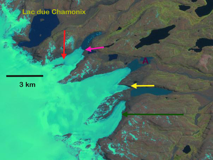
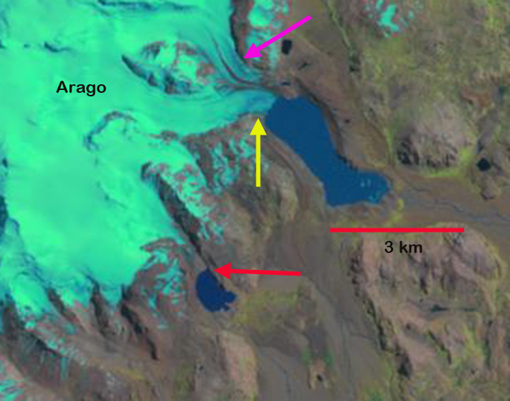
Cobre Glacier, Argentina in false color Sentinel 2 images from Jnauary 13, 2022 and March 16, 2022. Note the expansion of bedrock area amidst the glacier at Point A, glacier fragmenting at Point B and Point C.

Cobre Glacier drains east from Cerro Orejas a 3949 m peak on the Chile-Argentina border and discharges into the Rio Tordillo. The summer of 2022 has been a difficult season for glaciers in the Central Andes of Chile and Argentina as has been observed with early snowpack loss on Bajo del Plomo Glacier,  Cortaderal GlacierPalomo Glacier, Volcan Overo Glacier and Olivares Beta and Gamma Glaciers.  Here we can utilize Sentinel 2 satellite imagery to observe the retreat from 2016-2022 and the area losses apparent during the summer of 2022.

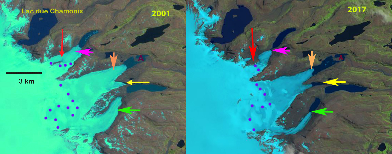
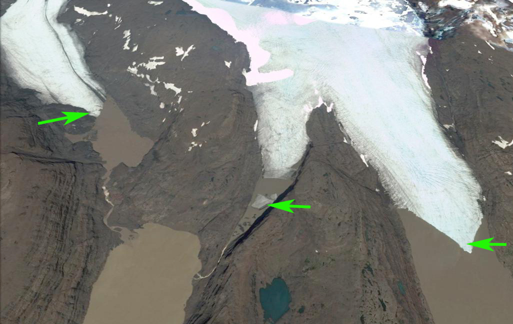
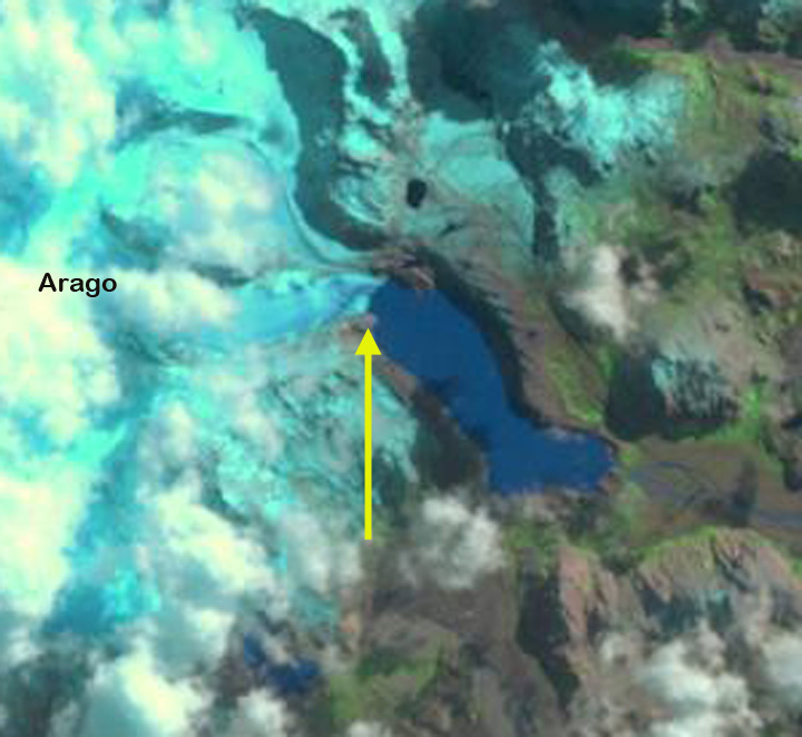
In March 2016 Cobre Glacier terminated on the northern shore of a proglacial lake at ~3000m.  By March 2022 the glacier had retreated 700 m from the lake in just six years. During this period thinning of the glacier had narrowed the connections at Point A-C, while a new lake basin is evolving at Point D.  Early summer warmth led to a rapid loss of snowpack on Cobre Glacier in 2022. By January 13, 2022 ~5% of the glacier had small pockets of snowcover above 3800 m. Bare ice glacier surfaces melt more rapidly than snow covered surfaces. After over two months of bare ice ablation the small areas of emergent bedrock on January 13, near Point A have enlarged and merged with the margin of the glacier by March 16. At Point B a small ice cap is separating from the main glacier. At Point C a narrow tongue of ice that had connected the main glacier to a small terminus segment has been severed.  At Point D margin retreat is leading to expansion of the proglacial lake along the margin of the glacier.  In just two summer months the impact of a single warm summer is evident on Cobre Glacier.  It is also evident that with no persistent accumulation zone this glacier cannot survive current climate( Pelto, 2010). Dussaillant et al (2019) identified slower mass loss  -0.28 m/year in this region from 2000-2018, than further south in the Patagonia Andes or north in the Tropical Andes. In 2022 the Central Andes are experiencing a rapid loss.

Cobre Glacier in Sentinel 2 images from March 2016 and March 2022. Illustrating retreat from 2016 terminus (red arrow) to 2022 terminus (yellow arrow). Fragmentation of the glacier underway at Point A-C is evident. A new evolving lake is at Point D.

Cook Ice Cap Outlet Glacier Retreat Lake Fromation, Kerguelen 2001-17


Comparison of eastern outlet glaciers of the Cook Ice Cap in 2001 and 2017 Landsat images.  Red arrow indicates a location of tributary separation. Pink arrow the 2017 terminus location of the northernmost glacier. Orange arrow the 2017 terminus location of the middle glacier.  Yellow arrow tip the 2001 terminus position of glacier ending in newly formed lake.  Green arrow the southernmost glacier 2017 terminus location. 

On the east side of the Cook Ice Cap on Kerguelen Island a series of outlet glaciers have retreated expanding and forming a new group of lakes.  Here we examine the changes from 2001-2017 along using Landsat imagery. Retreat of glacier in the region was examined by Berthier et al (2009) and is exemplified by the retreat of Ampere Glacier.  Verfaillie et al (2016) examined the surface mass balance using MODIS data, field data, and models.  They identified that accelerating glacier wastage on Kerguelen Island is due to reduced net accumulation and resulting rise in the transient snowline since the 1970s, when a significant warming began.

In 2001 at the red arrow is where the north tributary of a glacier ending in the northern most lake joins the main glacier.  In the second lake is a peninsula, marked with point A that the glacier terminus is 1 km from. The next two glaciers terminating at the yellow arrow and beyond the green arrow do not have lakes at their termini.  By 2014 the northern tributary has lost its connection with the main glacier terminating in the lake. The distance from the island for the middle glacier has increased.  A lake is forming at the yellow arrow. For the third glacier a lake has formed at the green arrow. In 2017 the northern glacier has retreated to the pink arrow a distance of  750 m and is no longer terminating in the lake. The terminus at the orange arrow has retreated  main terminus has retreated 900 m, expanding the lake it terminates in.   The glacier at the yellow arrow has retreated into a new lake basin, with a retreat of 850 m since 2001. The terminus is thin and in the Google Earth image indicates some substantial thin icebergs have separated from the glacier. The green arrow marks the 2017 terminus of the southern most lake. This glacier has retreated 950 m leading to the continued expansion of a new lake.  In just a decade we see the formation of two new lakes and the expansion of two others at the terminus of the eastern outlet glaciers of Cook Ice Cap, rapid landscape change driven by climate change.

2014 Landsat image of the eastern outlet glaciers of Cook Ice Cap.Red arrow indicates a location of tributary separation. Pink arrow the 2017 terminus location of the northernmost glacier. Orange arrow the 2017 terminus location of the middle glacier.  Yellow arrow tip the 2001 terminus position of glacier ending in newly formed lake.  Green arrow the southernmost glacier 2017 terminus location. 

Terminus of three outlet glaciers from left to right the green arrow, yellow arrow and orange arrow terminus glacier on the Landsat images.  The green arrows indicate places where the terminus or icebergs illustrates how thin the glacier ice is. 

Kerguelen Island Glacier Retreat Forms New Lake District

On the east side of the Cook Ice Cap on Kerguelen Island a series of outlet glaciers have retreated expanding and forming a new group of lakes, red arrow. This area is just south of Lac du Chamonix which has existed. Here we examine the changes from 2001-2014 along using Landsat imagery. This is a retreat examined by Berthier et al (2009), and exemplified by the retreat of Ampere Glacier and Aggasiz Glacier from the same ice cap. Kerguelen-Island-topo-Mapeast

In 2001 at the red arrow is the north tributary of a glacier ending in the northernmost lake at the pink arrow. In the second lake is an island, marked with point A, this glacier has a secondary terminus ending at the yellow arrow. The southernmost glacier examined at the green arrow has retreated from one lake and does not end in a lake. By 2011 the northern tributary is starting to separate losing its connection with the Cook Ice cap, red arrow and retreating from the pink arrow. The distance from the island for the middle glacier has increased. A lake is forming at the yellow arrow. For the third glacier a lake has formed at the green arrow. The 2013 Landsat image still has snowcover obscuring the glacier boundaries. In January 2014, it is evident that at the red arrow the northern tributary has lost all connection with the Cook Ice Cap. The main terminus has retreated 700 m, expanding the lake it terminates in. With the loss of the northern tributary the retreat will continue. The distance from the island at Point A to the terminus of the middle glacier has increased 900 m indicating the retreat since 2001. The glacier is nearly at the western end of the lake it terminates in. At the yellow arrow the new lake is now 900 m long indicating a retreat of slightly less than this. The green arrow marks the 2013 terminus in each image of the southern of the three glaciers. This glacier has retreated 800-900 m leading to the continued expansion of a new lake. In just a decade we see the formation of two new lakes and the expansion of two others at the terminus of the three eastern outlet glaciers of Cook Ice Cap.
lake district kerguelen 2001

lake district kerguelen 2011

lake district kerguelen 2013

lake district kerguelen 2014

Arago Glacier Retreat, Kerguelen Island

Kerguelen Island sits alone isolated at the edge of the furious fifties in the southern Indian Ocean. The island features numerous glaciers, the largest being the Cook Ice Cap at 400 square kilometers. Here we focus on the Arago Glacier and an adjacent glacier to the south on an icecap on the Raillier du Bay Peninsula Ice Cap using satellite imagery from 2001-2011. Arago Glacier descends east from the ice cap currently ending in a proglacial lake.
Kerguelen-Island-topo-Map
Kerguelen Island Map
arago area map
Rallier du Baty Peninsula Google Earth image
Berthier et al (2009)note that this glacier had retreated 3 km from 1964-2001. In 1964 the glacier filled the lake basin, yellow line in first figure below. They had a single profile across the glacier shortly above the terminus that indicated 80 km of thinning from 1964-2000 and 30 m from 2000-2005. The profile is the blue dotted line from their paper in the first figure below. In 2001 Arago Glacier terminated at the tip of a peninsula, yellow arrow. The Arago Glacier is joined just above the terminus by a tributary from the north, which has a substantial width in 2001 at the pink arrow. The glacier to its south ended at the northern end of a lake, red arrow. By 2006 Arago Glacier has retreated from the peninsula. Cloud cover obscures the glacier to the south. By 2011 Arago Glacier has retreated from the peninsula, 300-400 m since 2001, expanding the proglacial lake. The glacier tributary at the pink arrow width has declined substantially. This is indicative of a thinning glacier as well. The contribution of this tributary to the main terminus is quite limited by 2011. The glacier to the south at the red arrow has also retreated 300-400 m, leading to lake expansion there. This island is notoriously cloud covered, and I have not located an image with a clear view of the region since 2011, when I do the post will be updated. The retreat of Arago Glacier follows the pattern of retreat of the glaciers of other glaciers on the island including Ampere Glacier and the northern outlet of the Cook Island Ice Cap
arago glacier 2001 map
Figure 8 from Berthier et al (2009)
arago galcier 2001
Landsat image in 2001

arago galcier 2006
Landsat image from 2006

arago glacier 2011
Landsat image from 2011

arago glacier 2014
Landsat image from 2014

Lapperent Outlet Thinning and Retreat, Kerguelen Island

Kerguelen Island sits alone at the edge of the furious fifties in the southern Indian Ocean. The island features numerous glaciers, the largest being the Cook Ice Cap at 400 square kilometers. A comparison of aerial images from 1963 and 2001 by Berthier et al (2009) indicated the ice cap had lost 21 % of its area in the 38 year period. In this paper they focused particular attention on the Ampere Glacier, pink arrow in first image, draining the southeast side of the ice cap, that had retreated 2800 meters from 1963 to 2006. Berthier et al (2009) had a second focus on the Lapparent Nunatak due north of the main terminus and close to the east terminus, referred to hear as the Lapparent Outlet. A nunatak is a ridge or mountain surrounded by a glacier, really an island in a sea of ice. The nunatak expanded from 1963-2001, in the second image below from Berthier et al (2009), but it was still surrounded by ice. . In this post we examine changes at the terminus and at several points upglacier in 2001 and 2011 Landsat imagery that indicate widespread thinning and deglaciation. In each image the letters are in the same location as are the colored arrows. The green arrow indicates the 2001 terminus of the outlet and the burgundy arrow the 2011 terminus, indicating a 2 km retreat in a single decade for the southern calving terminus and for the northern terminus above point D 2200 meters of retreat. In 2001 the region around letter D is a filled by the northern arm encircling the Lapparent Nunatak, by 2011 D is in a deglaciated valley. B marks the southern end of the 2011 terminus. F in 2011 marks a location where the Lapparent Outlet spills over a ridge into another valley, by 2011 the overflow has narrowed from 1100 meters to just 500 meters in ten years. The result is less ice flow into the secondary basin, including down a bedrock step to point E. Point E in 2001 is in the midst of the lower reach of the glacier. By 2011 there is no ice near point E as the glacier no longer descends to this lower step. Point A in a nunatak 4 km inland from the Ampere and Lapperent Outlet terminus, this nuntak has expanded from a long axis of 1100 meters to 1500 meters. Berthier et al (2009) had noted thinning around the Lapprent Nunatak of 150 to 250 m. This continued thinning since 2001 is leading to further expansion of the nunatak at A and to reduced ice spillover at point F. This island and glacier is experiencing the same climatic warming that is causing retreat of other glaciers in this circum-Antarctic latitude belt, Stephenson Glacier on Heard Island, Neumayer Glacieror Ross Hindle Glacier on South Georgia and on the north side of Cook Ice Cap, Kerguelen Ice Cap.

Cook Ice Cap Northern Outlet (Aggasiz Glacier) Retreat, new lake born Kerguelen Island

Kerguelen Island sits alone at the edge of the furious fifties in the southern Indian Ocean. The island features numerous glaciers, the largest being the Cook Ice Cap at 400 square kilometers. A comparison of aerial images from 1963 and 2001 by Berthier et al (2009) indicated the ice cap had lost 21 % of its area in the 38 year period. Le Bris et al (2008) in a related part of the aforementioned study noted that the retreat accelerated after 1970 and again after 2003, with thinning of 5 meters/year on Ampere Glacier and retreat of 75 m/year on Explorer Glacier on the east side of the ice cap. In this post we focus on the largest outlet glacier flowing north from the ice cap, Agassiz Glacier. A comparison of Google Earth (top), 2001 (middle) and 2011 (bottom) Landsat images indicate a significant retreat and formation of a new lake that is not evident in maps or Google Earth imagery. The red arrows point to the glacier tongue and in the 2011 image the black arrow indicates the new lake. Agassiz Glacier has lost its field hockey stick shaped hook and has retreated 2 km in just 10 years, the rate of 200 m/year is quite high even by Cook Ice Cap standards. The glacier is calving into the lake which can accelerate retreat. The terminus does not appear to be at a stable point, with a wide calving front in comparatively deep water. The retreat of this glacier fits the retreat of other glaciers on islands in the Southern Ocean, Arago Glacier, Stephenson Glacier, Neumayer and Ross Hindle