Sulmeneva Bay Glacier Retreat 1990-2018, Novaya Zemlya

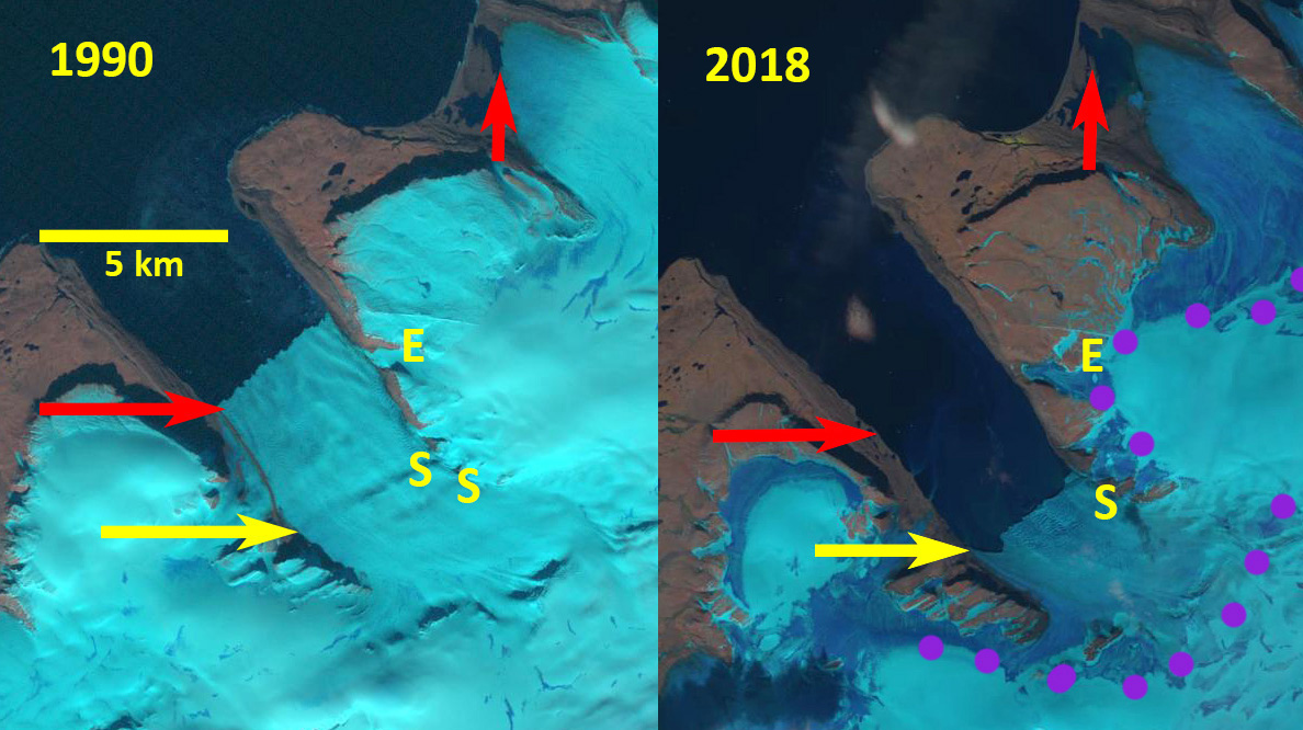
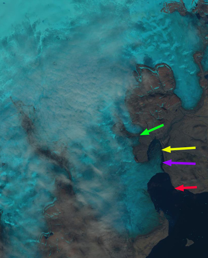
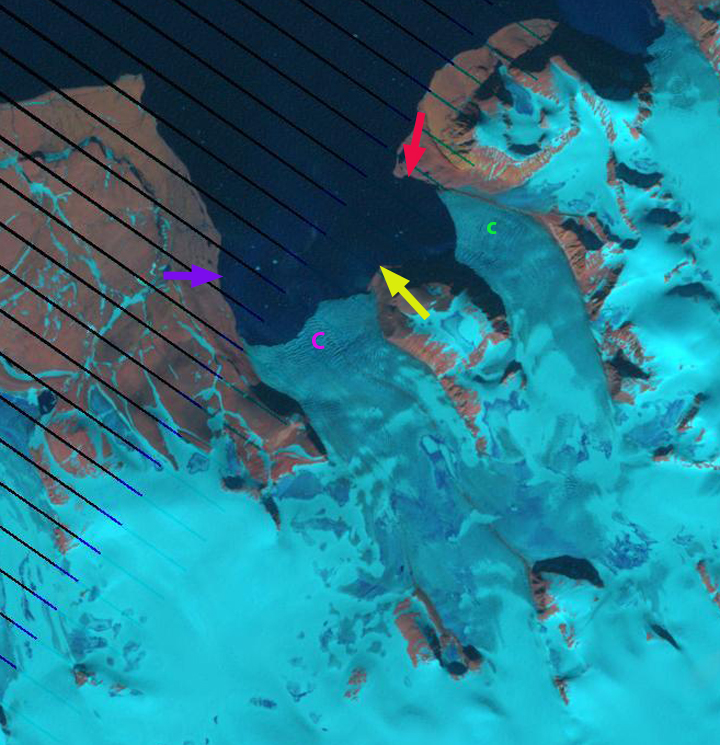
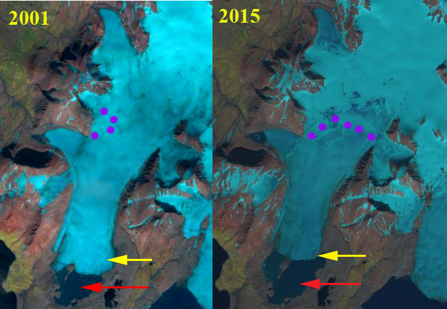
Sulmeneva Bay Glacier in Landsat images from 1990 and 2018.  Red arrow is the 1990 terminus location, yellow arrow the 2018 terminus location and pink dots the snowline.

Here we examine an unnamed glaciers, referred to here as Sulmeneva Bay Glacier, that terminated in a piedmont lobe near the northern shore of Sulmeneva Bay and just east of Lednikovoye Lake in central Novaya Zemlya. Sulmeneva Bay is on the west coast of Novaya Zemlya and is the southern most extent of the continuous glaciation that extends along the northern half of the island.  LEGOS (2006) identified a 1.24 km2 reduction in area of this glacier from 1990-2000. Carr et al (2014) identified an average retreat rate of 52 meters/year for tidewater glaciers on Novaya Zemlya from 1992 to 2010 and 5 meters/year for land terminating glaciers. The glacier is retreating like all tidewater glaciers in northern Novaya Zemlya, though they are not specifically tidewater the lake terminating glaciers were retreating at a similar rate of ~40 m/year from 1986-2015 (Carr et al., 2017). Here we use Landsat images to examine changes from 1990 to 2018.

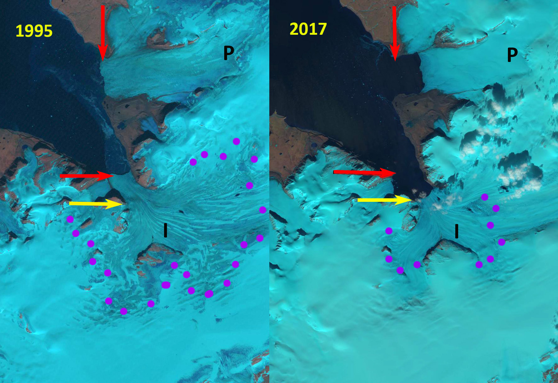
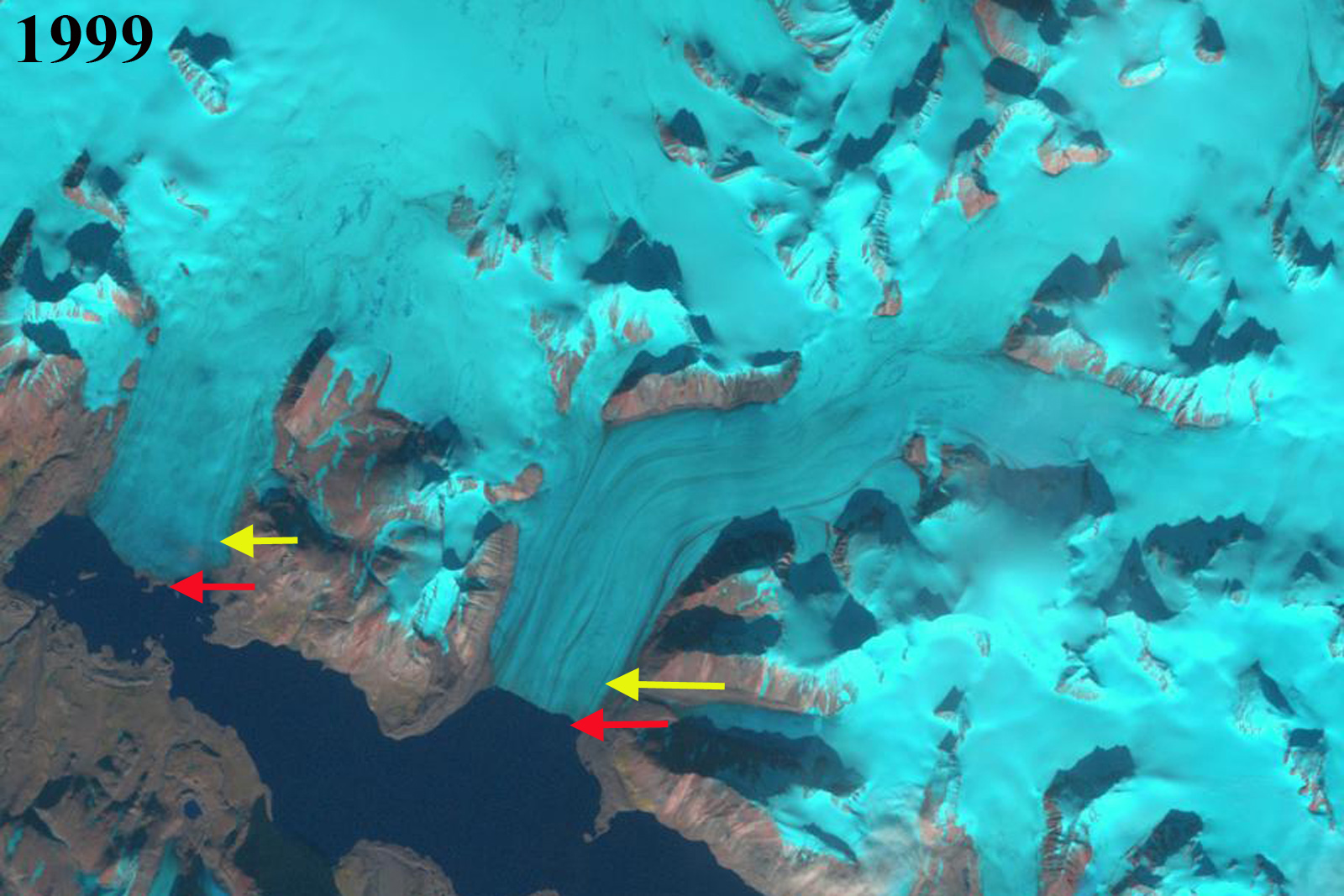
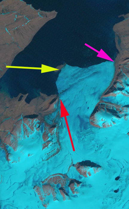
In 1990 Sulmeneva Bay Glacier terminates in a proglacial lake at the southern end of what will become an island in the lake. The lake is 1.1 km wide from the calving front to the southern shore, red arrow. The snowline in 1990 is at 550 m, while the head of the glacier is at 650 m.  By 2001 the glacier has retreated 700 m and the snowline is at 600 m reaching the ice divide in some areas. In 2015 the snowline is at 400 m and the lake has continued to expand with a north-south reach of 1.7 km. The glacier terminates at the northern end of the developing island.

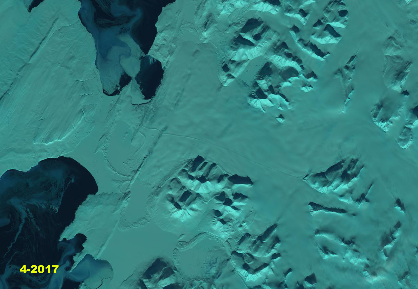
In August of 2018 the snowline is at 550 m, again leaving a limited accumulation zone.  By mid-September snowfall has lowered the snowline back to 200 m.  The glacier has now retreated from the central island in the proglacial lake.  This should lead to an increase in calving. The glacier has retreated 1.2 km since 1990 and the lake is now 2.2 km from the calving front to the southern shore.

The retreat here is similar to the glaciers of Lednikovoye Lake and to Sulmeneva Glacier which retreated less, but across a broader front.  What is evident is that the persistent high snowlines are leading to negative mass balances that will drive continued retreat. At Lednikovoye Lake high snowlines in 2000 and 2016 further indicate the spatial extent and temporal frequency of high snowlines in recent years.

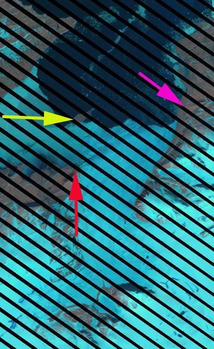
Sulmeneva Bay Glacier in Landsat images from 2010 and 2015.  Red arrow is the 1990 terminus location, yellow arrow the 2018 terminus location and pink dots the snowline.

Novaya Zemlya map produced by Christoph Hormann with Sulmeneva Bay Glacier (SSG) shown just west of Lednikovoye Lake.

Vera Glacier, Novaya Zemlya Retreat

Vera Glacier in Landsat images from 1990 and 2018. Red arrow is the 1990 terminus and yellow arrow the 2018 terminus location.  Purple dots indicate the snowline, E indicates the eastern tributary and S the bedrock step.

Vera Glacier is on the west coast of Northern Noyaya Zemlya terminating in a fjord  Carr et al (2017) examined Novaya Zemlya glacier retreat between 1973/76 and 2015, finding that between 2000 and 2013, retreat rates were significantly higher on marine-terminating outlet glaciers than during the previous 27 years. Here we examine changes in Vear Glacier from 1990-2018 using Landsat imagery.

In 1990 the glacier terminated at the red arrow 1 km beyond a tributary entering from the east.  There is a marked rib at the yellow arrow in the 1990 image, suggesting a bedrock step beneath the glacier.   In 1995 the tributary from the east no longer reaches the main glacier, the terminus front has retreated several hundred meters and the snowline is at 300 m.  By 2016 the terminus has retreated well south of the eastern tributary nearly doubling the length of the fjord.  The terminus is now close to the bedrock step seen in the 1990 image.  By 2018 the glacier has retreated The snowline is again at  300 m. By 2018 Vera Glacier has retreated 3500 m since 1990, including past a second eastern tributary.  The fjord is now over10 km long.  The glacier is at the bedrock step with another bedrock step 500-1000 m upglacier.  Each step should indicate a reduced water depth and reduced calving.  The snowline in early August in 2018 is at 300 m, but rises to 600 m by the end of the month on neighboring Inostrantseva Glacier.  Pelto (2017) and Carr et al (2017)  discuss the role reduced Barents Sea Ice duration played in the retreat.  The retreat here is similar to that of other nearby Novaya Zemlya glaciers such as Mack and Velkena Glacier or  Inostrantseva Glacier.

The glaciers in this region are also a potential source for radiation from nuclear weapons testing by Russia from 1957-1962.

Vera Glacier in Landsat images from 1995 and 2016. Red arrow is the 1990 terminus and yellow arrow the 2018 terminus location.  Purple dots indicate the snowline and E indicates the eastern tributary.

Inostrantseva Glacier, Novaya Zemlya Retreat Drives Separation

Inostrantseva Glacier (I) and Pavlova Glacier (P), Novaya Zemlya in 1995 and 2017 Landsat images.  Red arrow indicates the 1995 terminus, yellow arrow the 2017 terminus and purple dots the snowline. 

Inostrantseva Glacier is on the west coast of Northern Noyaya Zemlya terminating in Inostrantseva Bay along with Pavlova Glacier.  Carr et al (2017) examined Novaya Zemlya glacier retreat between 1973/76 and 2015, finding that between 2000 and 2013, retreat rates were significantly higher on marine-terminating outlet glaciers than during the previous 27 years. Here we examine changes in Inostrantseva Glacier from 1995-2018 using Landsat imagery.

In 1995 the glacier terminated at the red arrow, just beyond the junction with a tributary joining from the west.  The snowline is at 400-450 m, with the divide of the icefield at ~600 m. Pavlova Glacier terminus is at outer margin of its embayment.  In 2000 there is limited terminus change, and the snowline in this July image is at 250-300 m. By 2013 Inostrantseva Glacier has separated has separated from the western tributary and has retreated 2800 m since 2000.  The snowline is at 350-400 m.  Pavlova Glacier has retreated creating an embayment that is 1.5-2.0 km long.  In 2017 the terminus has retreated 2800-3000 m since 1995. The snowline is at 300 m.  In 2018 there is not a clear view of the terminus of the Inostrantseva Glacier, what is noteworthy is that the melt zone/snow line for the first time I have seen crosses the entire icefield, being higher than the divide at 600 m.  On August 8, there is still some snowpack remaining along the divide.  By August 31 the melt zone extends across the entire icefield. The high snowline indicates 2018 will be a year of significant mass loss on this portion of the Novaya Zemlya ice cap. Pelto (2017) and Carr et al (2017)  discuss the role reduced Barents Sea Ice duration played in the retreat.  Carr et al (2017) indicate the fastest retreat of Inostrantseva was from 2005-2010. The retreat here is similar to that of other nearby Novaya Zemlya glaciers such as Vera Glacier,  Mack and Velkena Glacier or Chernysheva Glacier.

Inostrantseva Glacier (I) , Novaya Zemlya 8/8/2018 and 8/31/2018 Landsat images.  Red arrow indicates the 1995 terminus, yellow arrow the 2017 terminus and purple dots the snowline. Note the east margin of the icefield is shown and that the snowline/melt zone extends across the entire icefield.

Inostrantseva Glacier (I) and Pavlova Glacier (P), Novaya Zemlya in 2000 and 2013 Landsat images.  Red arrow indicates the 1995 terminus, yellow arrow the 2017 terminus and purple dots the snowline. 

Monacobreen Separates from Seligerbreen, Svalbard

Monacobreen Separation from Seligerbreen in 1999 and 2016 Landsat images.  The red arrow is the 1999 terminus location and yellow arrow the 2016 terminus location. 

Moancobreen  is a glacier that terminates at the head of Liefdefjorden , a branch of Woodfjorden in Spitsbergen, Svalbard. NW Spitsbergen is a region that has experienced extensive long term glacier thinning from 1965 to 2007 (Nuth et al, 2010). Svalbard is host to 163 tidewater glaciers with a collective calving front of 860 km (Błaszczyk et al, 2009), Monacobreen has a 4.4 km wide calving front.  The glacier has surged in the past. Oceanwide Expeditions has expeditions to the region that capture the beauty including the polar bears and ringed seals of the area. 

In 1999 Seligerbreen and Monacobreen had a joint terminus that was 6.5 km wide.  By 2013 the glaciers had separated and the tidewater terminus of Monacobreen was 4.4 km long.  Monacobreen had retreated 2200 m from 1999-2016. The snowline in 2016, see below, was at 525 m.  There are significant melt features apparent in the 2013 Google Earth image of the 500 m elevation area and melt ponds in the 1999 image. The retreat of Monacobreen  is similar to that of most tidewater glaciers in Svalbard such as,  PaierbreenHornbreen and Svitjodbreen.

Google Earth image of Monacobreen from 2013, indicating separation had occurred, note plume of sub glacial meltwater outflow. 

TopoSvalbard place name image of the area

Landsat image indicating melt features and snowline in 1999 and 2016 Landsat images. 

Melt water drainage features in the region from 400-550 m on Monacobreen

Nizkiy Glacier Embayment Expands Island Forms, Novaya Zemlya

Nizkiy Glacier in 1990 and 2016 Landsat images.  red arrows indicate locations of the 1990 terminus and yellow arrows the 2016 terminus.  Purple arrow indicates an expanding bedrock rib amidst the glacier and purple dots indicate the snowline.

Nizkiy  Glacier is on the west coast of the island reaching the Barents Sea Coast. The glaciers of northern Novaya Zemlya, Russia are truly generally out of sight out of mind. There remoteness and lack of importance as a water resource being the key reasons. It is particularly important to pay attention to these glaciers due to the recent changes in sea ice cover that have left a much longer duration of open water around the island particularly to the west in the Barents Sea.  Nizkiy lost 1.2  km2 in area  from 1990-2000  (LEGOS, 2006).  Carr et al (2014) identified an average retreat rate of 52 meters/year for tidewater glaciers on Novaya Zemlya from 1992 to 2010 and 5 meters/year for land terminating glaciers. Here we compare a Landsat image from 1990 and 2016.

The Nizkiy Glacier has several termini in lakes and one in the Barents Sea. The main terminus juts north out to the end of a peninsula in 1990, with an embayment developing from the peninsula across to the northern edge of the terminus. The middle terminus ends in a proglacial lake and in 1990 the terminus largely envelops an island in the lake. The southernmost terminus is in a proglacial lake shown is indicated by a red arrow as well. The 2016 Landsat image indicates the continued reduction in Nizkiy Glacier width reaching the peninsula at the yellow arrow, having retreated 1200 m from the 1990 position.  Hence, It will likely be quite soon when the proglacial lake with the island joins with the Barents Sea. The northern edge of the terminus has retreated little, but the size of the embayment between the northern edge and the peninsula has doubled since 1990.   A new island has been exposed in the proglacial lake between the main terminus and the peninsula.  The expansion of the proglacial lake on the north side of the glacier just inland of the main terminus has retreated 600 m.  The southernmost terminus has retreated 1100 m in an expanding proglacial lake. The purple arrow in the comparison image indicates an expanding rib of bedrock amidst the glacier. In 1990 the snowline is at  550 m.  In 2015 the snowline is at 450 m.  In July of 2016 the snowline is at  525 and in September is at 600 m. This glacier fits the pattern of other Novaya Zemlya glaciers (Pelto, 2016), such as Krayniy and Tasija.  The lack of sea ice off the west coast of Novaya Zemlya in April of 2017, seen below, is a continuation of the pattern of open water early in the melt season, enhancing frontal melt. Note the pattern of sea ice in mid-April of 2004-2012 below

2015 Landsat Image, pink arrows indicate a bedrock rib that thinning ice is making evident. Purple dots indicate the snowline.

September 2016 Landsat image indicating the snowline is at a high elevation late in the summer.  Pink arrows are proglacial lakes. 

April 2017 Landsat image, note the lack of sea ice in front of the glacier. 

April Sea ice around Novaya Zemlya 2004-2012. 

Sulmeneva Glacier Retreat from Lakes, Novaya Zemlya

Sulmeneva Glacier retreat in comparison of 1999 and 2016 Landsat images. Red arrow indicate the 1999 terminus position and yellow arrows 2016 terminus location. 

Sulmeneva Bay is on the west coast of Novaya Zemlya and is the southern most extent of the continuous glaciation that extends along the northern half of the island.  Here we examine an unnamed glaciers that terminates in a piedmont lobe near the shore of Sulmeneva Bay. The glacier flows south from a shared accumulation zone with glaciers of the Lednikovoye Lake area, which are retreating like all tidewater glaciers in northern Novaya Zemlya (LEGOS, 2006). The glacier in 1999 had a terminus front that measured 9.5 km.  Carr et al (2014) identified an average retreat rate of 52 meters/year for tidewater glaciers on Novaya Zemlya from 1992 to 2010 and 5 meters/year for land terminating glaciers.Here we use Landsat images to examine changes from 1999 to 2016.

The terminus of the glacier in 1999 terminates in three substantial and two smaller proglacial lakes, the three larger lakes were all 1 to 1.5 km across.  In 2000 the ablation season is further along and the lake levels somewhat higher, causing most of the expansion from 1999.  By 2015 the glacier has retreated from the easternmost lake, which has also expanded to 2 km long and 1.7 km wide.  In 2016 there is only a minor connection to the northeastern lake of the group that is now 2.1 km wide and 1.8 km long. Retreat of the terminus ranges from 600 m to 900 m along the terminus front that now measures 7.8 km, equating to an area loss of 4 square kilometers in the terminus lobe alone. A supralglacial lake has also formed at purple arrow in 2016 indicating substantial melting at an elevation of 400 m.

Red dots indicate the terminus of the glacier in 2000 Landsat.  

Yellow dots indicate the terminus in 2015 Landsat. 

Lednikovoye Glaciers, Novaya Zemlya 1999-2016 retreat

lenikovoye compare

Comparison of glaciers terminating in Lednikovoye Lake in central Svalbard in 2000 and 2016. Red arrow is the 2000 terminus location and yellow arrows the 2016 terminus location.

Lednikovoye Lake in central Novaya Zemlya has four glaciers terminating in it. Here we examine the two unnamed glaciers that discharge into the northwest portion of the lake. The glaciers are retreating like all tidewater glaciers in northern Novaya Zemlya, though they are not specifically tidewater (LEGOS, 2006). LEGOS (2006) identified a 2.7 square kilometer reduction in area of the two glaciers from 1990-2000.  Carr et al (2014) identified an average retreat rate of 52 meters/year for tidewater glaciers on Novaya Zemlya from 1992 to 2010 and 5 meters/year for land terminating glaciers.Here we use Landsat images to examine changes from 1999 to 2016.

In 1999 and 2000 the western Lednikovoye Glacier ended on an island, the eastern Lednikovoye Glacier extended past the exit of a glacier filled valley entering from the east.  By 2016 the western terminus had retreated 800 meters from the newly developed island.  The eastern terminus had retreated a similar amount now ending near the center of the valley entering on the east.  The glacier in that eastern valley has retreated 600 m from 1999 to 2016. The snowline in 2000 and 2016 is at ~500 m, with a significant remaining accumulation zone.  There is limited upglacier thinning suggesting that retreat will not become rapid.  The reduced rate of retreat of the Lednikovoye Glacier’s versus tidewater glacier of Novaya Zemlya suggests the importance of both sea ice reduction and sea surface temperature increase to the retreat rate of the latter such as Krayniy Glacier, Tasija Glacier and Chernysheva Glacier.

ledknikovoye 1999

lednikovoye 2015

Krayniy Glacier Retreat, Novaya Zemlya

kraniy

Krayniy Glacier (Ky) comparison in 1990 and 2015 Landsat images.  Red arrow is 1990 terminus and yellow arrow is the 2015 terminus.  Purple arrows indicate upglacier thinning and green arrow a location of a glacier dammed lake.

Krayniy Glacier is an outlet glacier that drains the northern side of the Novaya Zemlya Ice Cap into the Barents Sea. This outlet glacier is just southwest of Tasija Glacier (T) and like that glacier has retreated over 1.2 km since 1988. Krayniy Glacier has been retreating like all tidewater glaciers in northern Novaya Zemlya (LEGOS, 2006). The terminus of the glacier has a pinning point on an island at present. Carr et al (2014) identified an average retreat rate of 52 meters/year for tidewater glaciers on Novaya Zemlya from 1992 to 2010 and 5 meters/year for land terminating glaciers. The increased retreat rate coincides with the depletion of ice cover in the Barents Sea region and a warming of the ocean. Both would lead to increased calving due to more frontal ablation and notch development similar to at Svalbard (Petlicki et al. 2015).  The spring of 2016 features an ice free west coast of Novaya Zemlya leading to enhanced calving front melting.

In 1990 the glacier had an east west terminus across the head of the fjord.  There was a substantial glacier dammed lake impounded by the glacier (green arrow), and there was a narrow connection with Tasija Glacier.  The glacier dammed lake persisted in Landsat images in 1999, 2000, 2003 and 2006.  In 2013 the proglacial lake had drained.  In 2014 and 2015 the lake has not reformed, an indication of glacier thinning at the outlet location. This thinning is evident at both purple arrows,where the connection with the Tasija Glacier has been severed and a substantial nunatak has emerged amidst the glacier. From 1990 to 2015 the glacier has retreated more on the eastern margin with 1250 of retreat opening up the embayment.  Retreat at the island in the glacier center has been 500 m since 1990. The western section of the glacier has retreated little. The eastern embayment will continue to drive retreat and glacier thinning that will reduce contact with the island pinning the eastern half of the glacier.  The thinning is evident at the purple arrows. The glacier will likely retreat from this island in a fashion similar to Tasija and Chernysheva, which will lead to increased rate of retreat of the entire ice front.

kraniy lake

1988, 2006 and 2014 Landsat images indicating the continued presence of glacier dammed lake from 1988-2006 and continued absence from 2014 and 2015.arctic.seaice4262016

Sea ice image from Cryosphere Today

Vilkitkogo Glacier Rapid Retreat, Novaya Zemlya 1990-2015

vilkitskogo compare

Figure 7.4.  Vilkitskogo South Glacier (Vs) and Vilkitskogo North Glacier (Vn) compared in 1990 and 2015 Landsat images.  Red arrows indicate 1990 terminus positions, yellow arrows 2015 terminus positions and purple arrows upglacier thinning.

Vilkitskogo Glacier has two termini that were nearly joined in Vilkitsky Bay in 1990.  The glacier flows from the Northern Novaya Zemlya Ice Cap to the west coast and the Barents Sea. The glacier has been retreating like all tidewater glaciers in northern Novaya Zemlya (LEGOS, 2006).  Carr et al (2014) identified an average retreat rate of 52 meters/year for tidewater glaciers on Novaya Zemlya from 1992 to 2010 and 5 meters/year for land terminating glaciers. For Vilkitskogo they indicate retreat into a widening fjord, and that the south arm has a potential bathymetric pinning point. The increased retreat rate coincides with the depletion of ice cover in the Barents Sea region and a warming of the ocean. Both would lead to increased calving due to more frontal ablation and notch development similar to at Svalbard (Petlicki et al. 2015)

The north and south glaciers both terminated at the mouth of their respective fjords in 1990, with the southern arm ending on a small island/peninsula extension. In 1994 there is limited evident retreat.  By 2001 embayments had developed particularly along the peninsula separating them.  By 2015 Vilkitskogo North has retreated 5000 m along the northern side of the fjord and 4000 m along the south side since 1990.  This fjord has no evident pinning points, and the rapid calving retreat should continue.  Vilkitskogo South has retreated 1000 m on the west side and 1800 m on the east side.The retreat has exposed a new island in the center of the glacier.  The glacier is currently terminating on another island.  Retreat from this pinning point will allow more rapid retreat to ensue.  Upglacier thinning is evident in the expansion of bedrock areas and medial moraine width, purple arrows. This indicates the retreat will be ongoing. There is still a large are of snowcover across the summit of the ice cap each year. The retreat has the same unfolding story as Krivosheina, Nizkiy and Glasova Glacier

vilkitskogo1994

1994 Landsat Image

vilkitskogo 2001

2001 Landsat image

Retreat forms Embayment at Kropotkina Glacier in Novaya Zemlya

Kropotkina Glacier is a tidewater glacier on the southeast coast of Novaya Zemlya that drain into Vlaseva Bay.  The glaciers terminate in the Kara Sea and has been retreating like all tidewater glaciers in Novaya Zemlya LEGOS, 2006 .  The map shown below from this project indicate the lack of an embayment in 1952, red dashed line and limited retreat from 1952-1988, with 1988 being the yellow line. Carr et al (2014) identified an average retreat rate of 52 meters/year for tidewater glaciers on Novaya Zemlya from 1992 to 2010 and 5 meters/year for land terminating glaciers.   Here we examine Landsat imagery from 1988 to 2013 to identify changes in Kropotkina Glacier.

kropots map

In each image the colored arrows are in the same location. In 1988 the terminus is just beyond the red arrow indicating a peninsula on the east side of the terminus. The yellow arrow indicates a lake beyond an eastern terminus lobe with limited drainage down a river adjacent to the glacier, purple arrow. Two smaller glacier termini are joined at the green arrow. By 1998 there is a minor retreat of the main terminus on both the east and west side. Little change is seen elsewhere. By 2011 a substantial embayment has developed above the red arrow. Retreat is limited on the western side of the terminus. The eastern terminus lobe has retreated as well and the drainage channel adjacent to the glacier is less restricted leading to a less extensive lake. The lake is mostly filling the region occupied by ice 13 years before.

In 2014 there is cloud cover over much of the glacier but the terminus is clear. The easternmost terminus lobe is collapsing, and is not surrounded by a lake, yellow arrow. The purple arrow drainage river is no longer necessary as there is lake connectivity. The main terminus to the east has retreated to the entrance to the lake for the eastern terminus lobe, this a 2.8 km retreat. The western side of the glacier remains aground on a peninsula, but has receded 500 m. How long before this part of the terminus to retreats into the expanding embayment. An are of more 7 square kilometers has gone from glacier ice to embayment in the last 25 years, almost all within the last 13 years. The retreat has mainly been via calving, and with an expanding calving front and reduced pinning points along the margin, the rapid retreat and area loss is not over. The beginning of rapid retreat coincides with the onset of rapid decline in sea ice extent in the Kara Sea (Perovich et al., 2014).

This ongoing retreat is illustrated by Krivosheina, Chernysheva, Roze and Sredniy and Taisija Glacier also in northern Novaya Zemlya.

kropots 1988b

1988 Landsat image

kropots 1998
1998 Landsat image
kropots 2011
2011 Landsat image
kropots 2014
2014 Landsat image

Mack and Velkena Glacier Retreat Novaya Zemlya 1988-2013

Mack and Velkena Glacier are tidewater glaciers on the northwest coast of Novaya Zemlya that drain into Legzdina Gulf.  The glaciers terminate in the Barents Sea and have been retreating like all tidewater glaciers in northern Novaya Zemlya LEGOS, 2006).  The map shown below from this project indicate the glaciers joined in 1952 and 1976 and separated by less than 1 km in 1988. Carr et al (2014) identified an average retreat rate of 52 meters/year for tidewater glaciers on Novaya Zemlya from 1992 to 2010 and 5 meters/year for land terminating glaciers. This ongoing retreat is illustrated by Krivosheina, Chernysheva, Roze and Sredniy; and Taisija Glacier also in northern Novaya Zemlya.  Here we examine Landsat imagery from 1988 to 2013 to identify changes in Mack and Velkena Glacier.

map_8_landsat.cdr

Map of Velkena and Mack Glacier area from Sharov et al (2006) at LEGOS.  The red dashed line is 1952, green dashed is 1976, yellow dashed is 1988 and solid purple is 2001.

The arrows and letter in each image are at fixed locations: the yellow arrow indicates the peninsula where Velkena and Mack Glacier separated.  The red arrow indicates the 1998 eastern terminus of Mack Glacier and the purple arrow indicates the 1988 position of the western terminus of Velkena Glacier. The green C and pink C respectively indicate areas of intense crevassing in 2013. In 1988 the glaciers are separated by just 500 m adjacent to yellow arrow, the crevassing is limited at both C’s.  In 2000 Velkena and Mack Glacier are now separated by 1.4 km, retreat of Mack from the red arrow is 500 m and retreat of Velkena Glacier from the purple arrow is 600 m. In 2006 Mack Glacier has retreated 1000 meters from the red arrow, and Velkena Glacier has retreated 1200 meters from the purple arrow.  Extensive crevassing is not yet evident at C.  

In 2011 at both locations crevassing is readily apparent in the satellite imagery. Retreat has continued for both glaciers 1250 m for Mack Glacier from red arrow and 1600 m for Velkena Glacier from purple arrow.  In 2013 the extensive crevasses zone (C) for both glaciers is within 500 m of the icefront.  The increase in crevassing is indicative of glacier acceleration, this is likely due to a steeper slope of the glacier near the current terminus.  This also suggests retreat will remain rapid in the near future. Retreat of Mack Glacier from 1988-2013 has been 1.8 km on the east side, red arrow, and 2 km on the west side.  On Velkena Glacier retreat has been 2.8 km on the west side, purple arrow, and 1 km on the east side. Both glaciers have been receding at a rate greater than the 50 meters/year noted as average by Carr et al. (2014). Anomalies for sea surface temperature along this section of sea ice free Novaya Zemlya are well above average in May 2015, which should lead to continued calving retreat.

maka 1988
1988 Landsat Image
maka 2000
2000 Landsat Image
maka 2006
2006 Landsat Image
maka 2011
2011 Landsat Image
maka 2013
2013 Landsat Image

Chernysheva Glacier Retreat, Novaya Zemlya

Chernysheva Glacier is on the northwest coast of Novaya Zemlya. The glacier terminates in the Barents Sea and has been retreating like all tidewater glaciers in northern Novaya Zemlya (LEGOS, 2006) This glaciers retreat follows the pattern of Krivosheina, Roze and Sredniy and Taisija Glacier. In this post we examine the changes using Landsat imagery from 1988, 2006 and 2011. The flow of the glacier from the main ice cap is indicated by blue arrows. The yellow arrow in each image indicates an island, the red arrow a bedrock ridge that extends under the ice, and the pink arrow the east margin of the terminus in 1988.

chernysheva ge
Google Earth image

In 1988 the glacier ended on the island which is a pinning point that would limit calving at the time. The 1988 image is very clear and the ridge with the bulge in the ice over it seems to extend 70% of the way across the glacier. In 2006 the glacier has pulled back from the island, there is however sea ice between the glacier front and the island, which has several icebergs embedded in it. By 2011 the glacier retreat from this island is 3100 m. The retreat from the east margin is 2600 m. The bedrock ridge at the red arrow should provide some stability and slow the retreat rate on the west side, it does not appear to extend to the eastern margin and this may continue to retreat apace. Interestingly the embayment here is very similar to that of Nizkiy and Glasova Glacier, which must be due to the similar geology. The reduction in duration of Barents Sea ice cover ice in front of the glacier has certainly helped to increase recent retreat.
chernysheva 1988 1988 Landsat image

chernysheva 2006
2006 Landsat image

chernysheva 2011
2011 Landsat image