Qiaqing Glacier Retreat & Lake Expansion, China

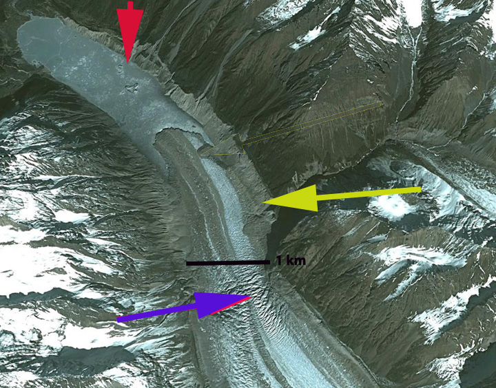
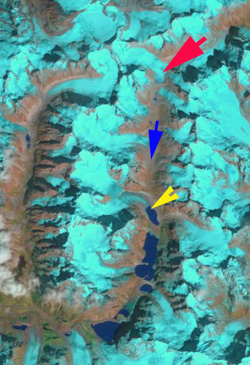
Qiaqing Glacier in 1992 and 2017 Landsat images indicating flow, blue arrows, 1992 terminus at red arrow and 2017 terminus at yellow arrow. tributaries A, B and C. 

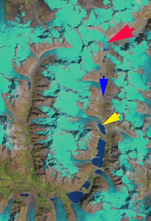
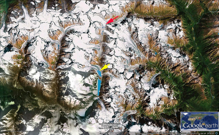
“Qiaqing” Glacier drains southeast from the Kona Kangri Massif at the eastern part of the Nyainqentanglha Shan. The glacier ends in a lake before feeding into the Parlung Zangbo and then Yarlung Tsanpo. This glacier feeds the Parlung Zangbo which is the site of numerous planned hydropower projects, last image, before joining the Yarlung Tsanpo which becomes the Brahmaputra River. The Zangmu Dam went online in 2015, this hydropower facility will produce 2.5 billion kilowatt-hours of electricity a year.  Wu et al. (2016) examined glacier change in the Nyainqentanglha Range from 1970-2014 noting an accelerating shrinkage of glaciers,with glacier area decreasing by 244  km2 or ~27%, with the western part of the range faring worse.  Wang and others (2011) note in the nearby Boshula Range that glacial lakes have expanded from 1970-2009 by 19% and the area that is glacier covered has decline by 13% during the 1970-2009 period.

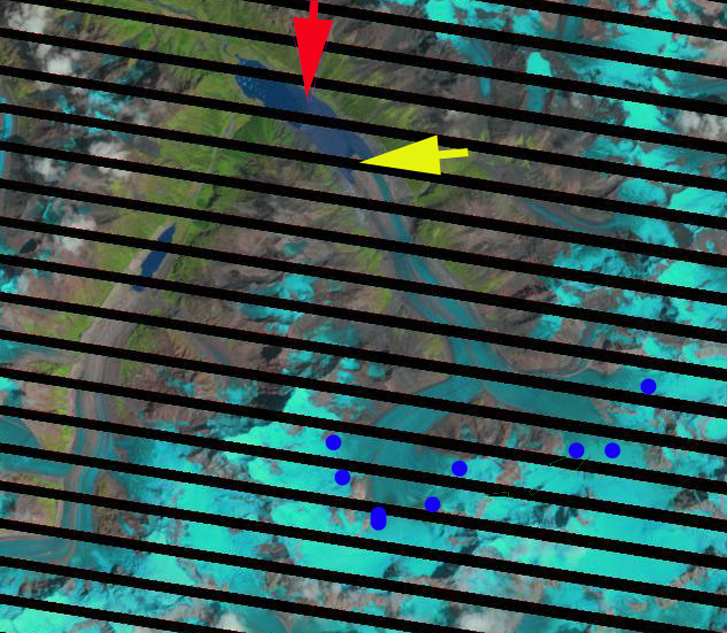
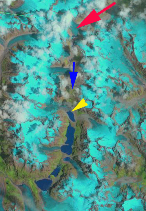
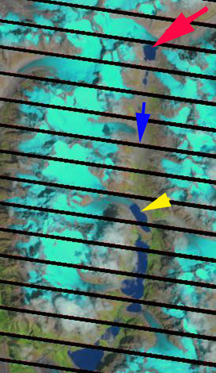
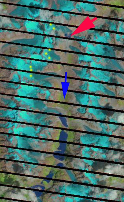
Here we examine Landsat images from 1992 to 2017 to identify changes of Qiaqing Glacier. In 1992 the glacier terminated in a 1.5 km long proglaical lake with tributary A just separated from the glacier and tributary B and C joining the glacier on a wide front. In 1999 the snowline is at 5200 m the glacier has retreated several hundred meters and the blue ice of tributary B and C still reach the main glacier.  In 2015 the snowline is at  5000 m.  In 2016 the snowline is at 5200 m, a few icebergs are visible in the lake and tributary B and C  are disconnecting from the glacier, and the terminus has retreated upvalley from the former location of connection with tributary A.  By 2017 the terminus has retreated  1700 m since 1992, a rate of ~68 m/year.  The proglacial lake is now over 3 km long. The retreat is enhanced by the lake, but not driven by it.  The high snowlines above 5000 m leave an insufficient accumulation zone to maintain the current glacier size. The retreat here is similar to that of Thong Wuk Glacier and Jiongla Glacier.

Qiaqing Glacier in 1999, 2015 and 2016 Landsat images; 1992 terminus at red arrow and 2017 terminus at yellow arrow.  Purple dots indicate the snowline. 

Jiongla Glacier, China Rapid Retreat 1988-2015

jionla compare

Jiongla Glacier retreat right and Jiangyegong Glacier left retreat from 1988 to 2015 in Landsat images.  The red arrow is the 1988 terminus and the yellow arrow the 2015 terminus. Jiongla Glacier retreated 3200 m and Jiangyegong Glacier 800 m. 

Jiongla Glacier is at the northern boundary of the Brahmaputra River Basin at the east end of the Nyainqentanglha Shan. The glacier drains the western slopes of Koma Kangri Peak and ends in a lake before feeding into the Parlung Zangbo and then Yarlung Tsanpo. his glacier feeds the Parlung Zangbo which is the site of numerous planned hydropower projects, last image, before joining the Yarlung Tsanpo which becomes the Brahmaputra River. The Zangmu Dam went online in 2015, this hydropower facility will produce 2.5 billion kilowatt-hours of electricity a year. In a study by Tobias Bolch et al (2010) in the western Nyainqêntanglha Mountains glacier area decreased by 6% between 1976 and 2001 and continued to shrink from 2001–2009. Li et al (2010) examined glacier change over the last several decades in China and found ubiquitous glacier retreat and commonly lake formation as glaciers retreated. Ninglian and Shichang (2014) in the China National Report on Cryospheric Sciences noted a loss in glacier area of 15 to 17 % in the region. Here we examine satellite imagery from 1988, 2000, 2009, 2010, 2011 and 2015. The red arrow denotes the 1988 terminus and the yellow arrow the 2011 terminus.

In 1988 the lake where Jiongla Glacier ends is at 2 km long. By 2000 the glacier has retreated 1300 meters. In the 2003 terminus closeup that indicates vigorous flow through an icefall, purple arrow, 2 km behind the terminus. This indicates the lake will end before this point and the glacier does not have a substantial stagnant terminus tongue. By 2011 the lake is 4 km long, a 2 km retreat in 20 years. There are icebergs visible in the lake particularly in the 2003, 2009 and 2011 images indicating that this one a key reason for rapid recent retreat. In reviewing the satellite images for the region cloud cover made it difficult to find imagery near the end of the melt season. By 2015 the lake is 5200 m long indicating a 3200 m retreat from 1988-2015.  The terminus is now within 500 of the increase in surface slope that suggests the end of the lake, and likely the end of the current rapid retreat. The 2011 image is from near the end of the melt season and indicates a snowline at 5150 m, blue dots, this is too high for equilibrium, with limited glacier area above 5500 m and the terminus at 4000 meters. This suggests that retreat will continue.   The retreat here is similar to that of Thong Wuk Glacier and Requiang Glacier.

The neighboring Jiangyegong Glacier has experienced an 800 m retreat from 1988 to 2015.  This terminus remains low slopes and heavily debris covered. The debris will slow the retreat, while the low slope indicates the lake can continue to expand enhancing retreat.  This also suggests the rate of retreat will soon slow.T
jiongla2000

Landsat image 2000 with the yellow arrow indicating the 2011 terminus position and the red arrow the 1988 terminus position.

jiongla terminus2003 Google Earth Image

jiongla 2011

Landsat image 2011 with the yellow arrow indicating the 2011 terminus position and the red arrow the 1988 terminus position.


Yarlung Tsangpo HPP

Hydropower dams completed, under construction and proposed. 


Bode Zangbo Headwaters Glacier Retreat, Tibet, China

In the eastern portion of the Nyainqêntanglha Shan, there is a raindrop shaped group of mountains encircled by the Bode Zangbo to the west and Yu Chu Zangbo (maps indicate several names here) to the the east. At the headwater of the Bode Zangbo are a series of glaciers ending in valley occupied by several new lakes formed by glacier retreat. The Bode Zangbo is the site of a proposed new 9600 kW hydropower project financed by Datang Power International. The Bode Tsangbo than joins the Parlung Zangbo and then Yarlung Tsangpo that becomes the Brahmaputra River in India. Both of the latter rivers are the focus of ongoing intensive hydropower development as indicated by the map from Tashi Tsering, with most existing dams being upstream on the Yarlung, red arrow indicates glacier site. Here we focus on two glaciers in particular indicated by a red and yellow arrow in each Landsat or Google Earth image. Both glaciers are unnamed. In fact the first image is the area in general from Google Earth with all the layers activate to show names, and there are none in this mountain region. In the lower left of the image China National Road 318 is visible that in this region connects Bomê County and Nyingchi.
bode zangbo Yarlung Tsangpo HPP
The red arrow indicates a glacier that was 3 km long in 1986 beginning at 5500 m and ending at a moraine at 4900 m. The red arrow points to the low lying terminus piedmont lobe. The second glacier ends in a lake, with the yellow arrow indicating a peninsula on the northeast side of the lake where the glacier ends in 1986. The blue arrow simply indicates the drainage direction of the stream. In 1986 the Bode Zangbo Headwaters Glaciers at the red arrow has no lake at its terminus, the terminus has a toe that turns south down the main valley to end at a series of moraines. By 1999 a tiny lake is evident. In 2000 and the 2001 Google Earth image the lake is still barely detectable. By 2011 a full fledged deep blue lake has developed, where the terminus of the glacier had been. The lake is 600 m long and 400 m long, indicating a 550-600 m retreat in the last decade of the glacier. At the yellow arrow there is limited change from 1986 to 2000, with the glacier still ending in proximity to the peninsula. By 2011 the glacier has retreated 350 m from the 1986 position. The other glaciers in the valley have also been in retreat, but given the location of the scan line errors and clouds it is harder to point out the specific retreat. The yellow dots in the late summer 2011 image indicates the snowline at 5150 m. This is the same snowline and terminus behavior as noted for Jiongla Glacier 110 km west northwest. The glacier follows the pattern of many other glaciers retreating in the region leading to lake expansion, Longbasba Glacier.
bode zangbo 1986
1986 Landsat Image

boe zangbo 1999
1999 Landsat Image

bode zangbo 2000
2000 Landsat Image

bode zangbo glaciers ge
2001 Google Earth Image

bode zangbo 2011
2011 Landsat Image

bode zangbo 2011a
2011 Landsat Image