Cachalote Glacier, Chile Retreats From Lake and Separates

Cachalote Glacier in a 1984 Landsat image and 2019 Sentinel Image.  Red arrow is 1984 terminus location, yellow arrow the 2019 terminus location and the pink arrow a tributary to the glacier in 1984 that separates.

Cachalote Glacier is on the western edge of the Southern Patagonia Icefield, Chile. The glacier is not fed by the main icefield, but is connected to glaciers that are.  The glaciers of the SPI have been experiencing significant mass loss and overall retreat. Willis et al (2012) observed significant mass loss from 2000-2012 of −20.0  Gt per year. Davies and Glasser (2012) indicate this area had its most rapid retreat of the 1870-2011 period after 1986.

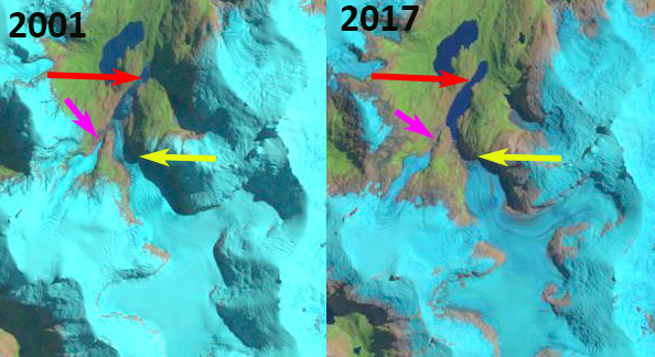
In 1984 Cachalote Glacier terminated in a proglacial that was ~600 m long, red arrow.  The glacier was joined by a tributary from the west ~1 km from the terminus, pink arrow.  By 2001 the tributary had separated from the main glacier. The glacier still terminated in the proglacial lake, but had retreated 1.5 km and the proglacial lake was now just over 2 km long.  In 2017 the glacier no longer reached the proglacial lake. In 2019 the glacier has retreated 2.6 km from its 1984 position, 30% of its entire length lost in the span of 35 years. The glacier no longer terminates in a lake and ends near the top of a steep slope, both suggest that retreat should decline for the near future.

This is a less spectacular retreat than at HPS-12 Glacier which is a short distance to the norther and is the fastest retreating glacier in the region or Dickson Glacier on the east side of the icefield, but as a percent of glacier length lost is as substantial.

Cachalote Glacier in a 2001 and 2017 Landsat images.  Red arrow is 1984 terminus location, yellow arrow the 2019 terminus location and the pink arrow a tributary to the glacier in 1984 that separates by 2001.

Cachalote Glacier with flow lines indicated. 

Glacier O’Higgins Calving Front Changes 1986-2018

Glacier O’Higgins in 1986 and 2018 Landsat images. Red arrow and line is the 1986 terminus position, pink line the 2002 terminus, green line the 2013 terminus, yellow arrows the 2018 terminus location, purple dots the snowline. Point A, B and C are locations at the margin of the glacier.

Glacier O’Higgins is a large outlet glacier of the Southern Patagonia Icefield (SPI) that terminates in Lago O’Higgins. Cassasa et al (1997) report on terminus changes from 1986 to 1995. In 1896 the glacier terminated on Isla Chica. By 1979 the glacier had retreated 13.8 km up an inlet of Lago O’Higgins.  The glacier was stable in this position through 1986 and had retreated 14.6 km by 1995. At this point the terminus had a 2.7 km east facing calving front, with the southern end of the terminus resting on the southern shore of the Lago O’Higgins Inlet. Meier et al (2018) note an 8 % area loss from 1985-2016 for the east side of the SPI.  Schaefer et al (2015) examined the mass balance of SPI and found Glacier O’Higgins had a calving flux of 2.15-2.97 cubic kilometers/year, and a calving front velocity of 2300 m/year. Malz et al (2018) note a mean elevation change of -1.04 m/year for Glacier O’Higgins from 2000-2016, with the greatest thinning near the terminus.  Here we use 1986-2018 Landsat imagery to identify changes.

In 1986 the terminus is firmly grounded on the south shore of the Lago O’Higgins inlet, with a 2.7 km long calving front, red arrows.  There is some melange in front of the south side of the terminus. There is debris covered ice between the terminus and tributary from the southwest that no longer quite reaches the main glacier.  By 2002 a new inlet has formed as the southwest tributary retreat and it debris covered terminus area melts away.  The southern margin has retreated into Lago O’Higgins and the calving front is now 3.5 km long.  In 2013 terminus retreat has been limited, but a narrow finger of open water has spread further along the southern margin of the glacier.  The calving front is now 4.0 km long.  In 2016 Google Earth imagery there is little change from 2013.  From 2016 to 2018 there is a substantial loss of terminus area as the glacier retreats 2500 m on the southern margin, 2100 m in the center and 1100 m on the north side. The calving front is now 2.6 km long.  The calving front is less vulnerable.  As the glacier retreats there is potential for the calving front to widen one kilometer upglacier of the calving front.  There also is an increase in crevassing and surface slope suggesting a reduction in water depth, which would reduce calving. At Point A you can see the expansion of the bedrock ridge that had been an isolated knob in 1986.  At Point B this area has been deglaciated as the tributary from the north has contracted.At Point C a narrow finger of glacier ice remained between bedrock and a knob, today it is just part of the ridge. The retreat of this glacier has been rapid from 2016 to 2018, but over the larger period the retreat is much less than the spectacular 13 km retreat of HSP-12 on the western side of the icefield or Onelli Glacier to the north.

Geoeye view of Glacier O’Higgins, yellow arrows indicate the 2018 terminus. Tr indicates the Little Ice Age trimline and IC is the Isla Chica where the glacier terminated in 1896.

Glacier O’Higgins in 2002 landsat image, red arrow is the 1986 terminus position and yellow arrows the 2018 terminus location.

Glacier O’Higgins in 2013 landsat image, red arrow is the 1986 terminus position and yellow arrows the 2018 terminus location.

Google Earth 2016 image of Glacier O’Higgins, note the extent of crevassing that indicates vigorous flow to the calving front in 2016. Several pockets of upwelling at the calving front.


Aneto Glacier, Pyrenees Area Loss & 2017 Snowcover Loss

Landsat and Sentinel 2 image from 8/24/2017 indicating the lack of retained snowcover on Aneto Glacier.  The bare glacier ice ablates faster than snow. 

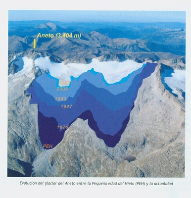
Aneto Glacier in the Pyrenees of Spain is listed as its largest glacier in a 1984 inventory. In 1984 the glacier had an area of 1.32 square kilometers and a length of 1.6 km (Serrat and Ventura, 2005). The glacier is located on the northeast side of Aneto Peak. The glacier is just a few kilometers from the rapidly retreating Maladeta Glacier. From 1984 to 2016, 20 of the 39 Pyrenean glaciers  have disappeared, resulting in a loss of glacier surface area from 805 hectares in 1984 to 242 hectares in 2016, a 70% loss in 32 years (Rico et al, 2017 is in press Pireneos).  The reduction since the Little Ice Age maximum is even greater, not figure below from Eñaut Izagirre.

Aneto Glacier is a steep north facing slope glacier that receives limited avalanche accumulation.   In 2017 Aneto Glacier has suffered from an intense melt season that has seen the loss of essentially all snowcover and consequent volume/area losses from ice ablation.  This is apparent in both Landsat and Sentinel images from Aug. 24th.  At the start of August the glacier was ~50% snowcovered and by Sept. 13th a snowstorm had at least briefly covered much of the glacier with a thin blanket of snow. In 2015 and 2016 retained snowcover was also limited.  There was less snowcover in early August of 2015 than in 2017, and by the end of the month in hazy imagery the snowpack is very limited.  In early September of 2016 there is less than 10% retained snowcover.  Satellite and Google Earth imagery reveal a frequent lack of retained snowcover in the last decade.  This indicates the lack of a consistent accumulation zone, which is a necessary feature for a glacier to survive  (Pelto, 2010). This is revealed by the annual horizons exposed in the 2007 Google Earth image.  

Landsat images of Aneto glacier from 8/3/2015 and 9/6/2016 illustrating limited snowcover near the end of the summer in 2016 and with a month of peak melt in 2015 snowcover is less than 50% of the glacier. 

Rico et al (2017) figure indicating LIA area to 2016 for Maladeta and Aneto Glacier, image provided by Eñaut Izagirre @Ernatio

2007 Google Earth image of Aneto Glacier illustrating lack of retained snowcover and the many annual layers exposed by the lack of an accumulation zone.

Sentinel 2 images of Aneto Glacier area in 2017 indicating there is significant remaining snowcover on 8/4 and again by 9/13.

Aneto Glacier, Spain-Retreating and Disappearing

Aneto Glacier in the Pyrenees of Spain is listed as its largest glacier in a 1984 inventory. In 1984 the glacier had an area of 1.32 square kilometers and a length of 1.6 km (Serrat and Ventura, 2005). The glacier is located on the northeast side of Aneto Peak. The glacier is just a few kilometers from the rapidly retreating Maladeta Glacier. SOER (2010) indicate that more than 80% of the glacier area on the Maladeta-Aneto Massif was lost between 1984 and 2007.
aneto area

aneto retreat map
Image from SOER (2010)

The glacier is too small to rely on our usual Landsat imagery. Here we focus on images from Google Earth and the Digital Globe. The glacier’s maximum top to bottom length by 2005 is no more than 600 meters, black dots indicate glaciers lower margin. The area in 2007 is 0.4 square kilometers by which time the glacier has developed a number of rock outcrops protruding through the thin ice. Snowcover in most images by late summer is minimal. This indicates the lack of a consistent accumulation zone, which a glacier cannot survive without (Pelto, 2010). The glacier has many exposed annual layers extending well upglacier, this is a further indication of the poor preservation of even old glacier ice. In 2005 and 2007 less than 10% of the glacier is snowcovered in the images which are not even at the end of the summer. This glacier is disappearing and like the Careser Glacier, Italy will break into several parts. The thin nature of the glacier is evident by looking up glacier from the terminus, last image from Gus Llobet (llobetgus-on Panaramio)

aneto glacier 2005
2005 Google Earth image, limited snowcover evident

aneto rock outcrops
Arrows indicate rock outcrops amidst the glacier.

aneto annual layers
2007 Digital Globe image
Annual layers of main glacier trunk in 2007aneto glacier slope
Images from Panaramio user-llobetgus