Is San Quintin Glacier Lake the fastest expanding lake this century in South America?

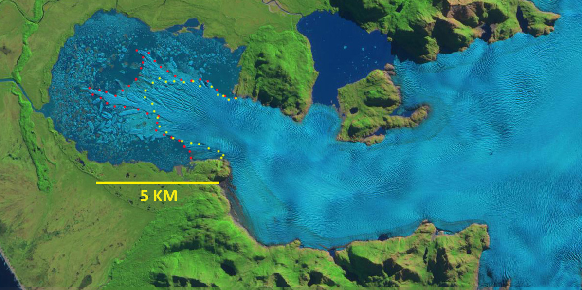
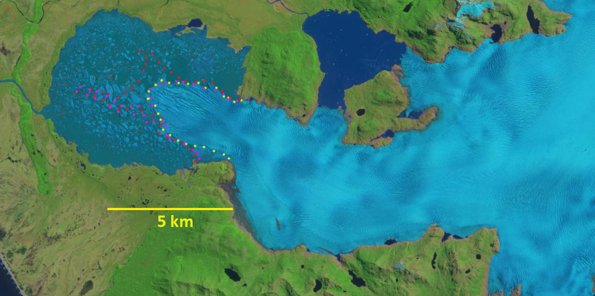
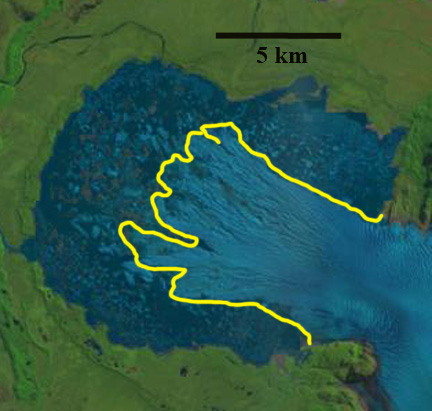
Landsat images of San Quintin Glacier from 2001 and 2020 indicate the expansion of both Lake A and Lake B due to glacier retreat. The Lake A basin as defined by the transect at the eastern narrow point, yellow line, has a total area of 41 km2 with the lake surface area now comprising 35.1 km2.

San Quintin is the largest glacier of the Northern Patagonia Icefield (NPI) at 790 km2 in 2001, flowing ~50 km west from the ice divide in the center of the ice cap.  San Quintin Glacier terminated largely on land until 1991 (Davies and Glasser, 2012). The velocity at the terminus has increased from 1987 to 2014 as the glacier has retreated rapidly into the expanding proglacial lake (Mouginot and Rignot, 2015).  As Pelto (2016) noted 19 of the 24 main outlet glaciers of the Northern Patagonia Icefield ended in a lake in 2015, all the lake termini retreated significantly in part because of calving losses leading to lake expansion in all cases. Glasser et al (2016) observed that proglacial and ice-proximal lakes of NPI increased from 112 to 198 km2. Loriaux and Cassasa (2013) reported that the combined area of the multiple San Quintin Glacier lakes expanded the most of any NPI from 1945-2011 increasing by 18 km2. The large evident crevasses/rifts perpendicular to the front indicate the terminus tongue has been partially afloat since at least 2014  Here we examine Landsat images from 1987-2020 to illustrate the changes. NASA’s Earth Observatory has high resolution images indicating the terminus in June 2014 and April 2017

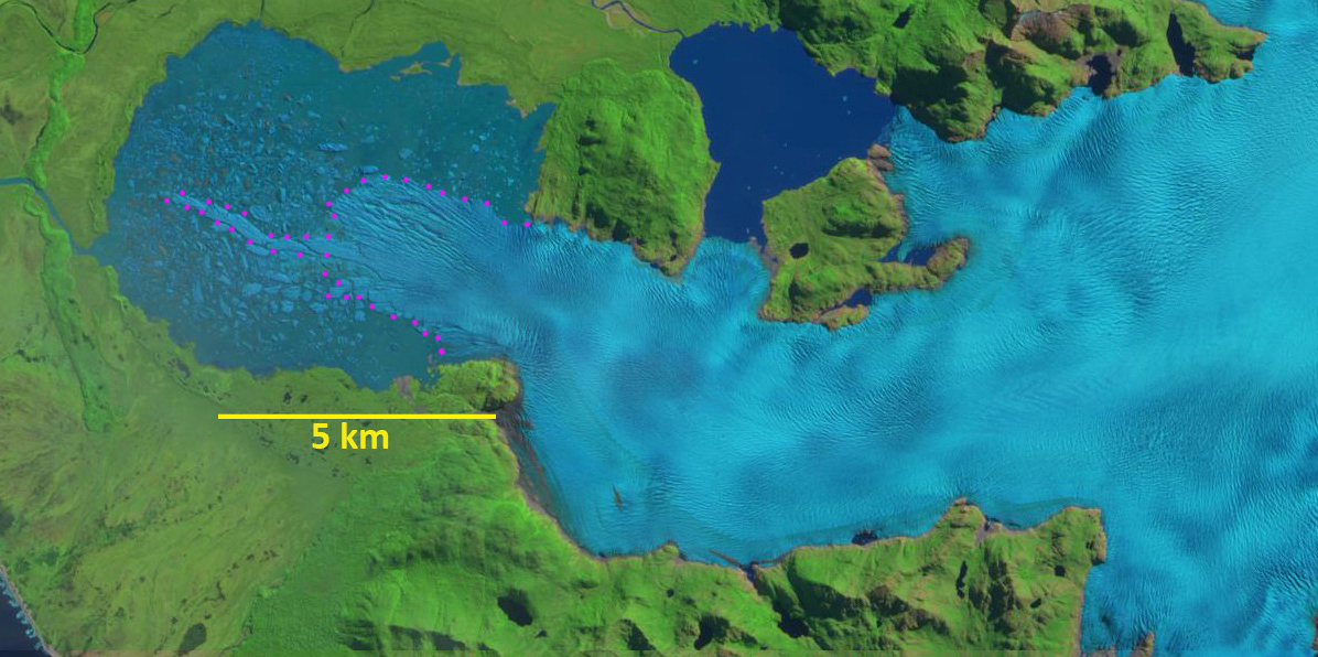
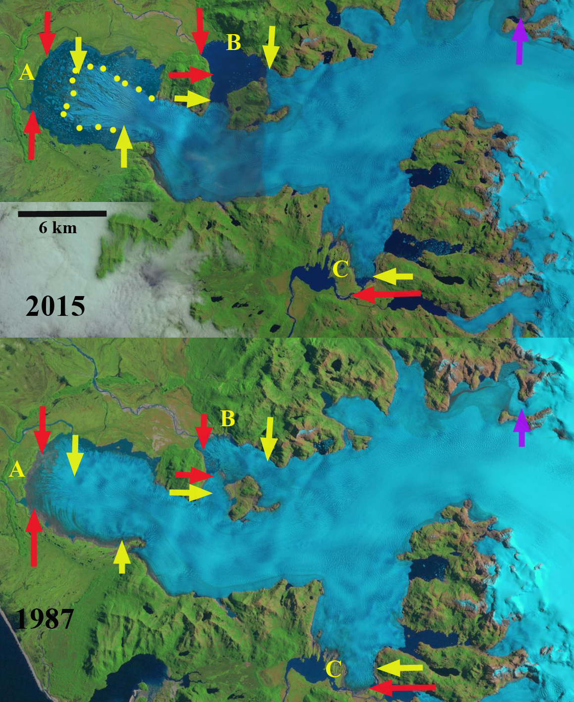
In 1987 it is a piedmont lobe with evident minimal marginal proglacial lake development beginning, with an area in Lake A of  3.2 km2 and Lake B of 2.2 km2.  The main lake, Lake A, in 2001 had expanded to an area of 14 km2, while Lake B had expanded to 6.5 km2. The main lake, Point A, had an area of 23.8 km2 in 2011 (Loriaux and Cassasa, 2013) . Lake B developing on the north side of the glacier, due to a 3500 m retreat, by 2015 had an area of 9.2 km2.  For Lake A the main terminus retreat of  2200 m from 1987-2015 and led to lake expansion to 34.3 km2. The southern terminus at Point C, has a narrow fringing lake and a retreat of 1100 meters from 1987-2015.

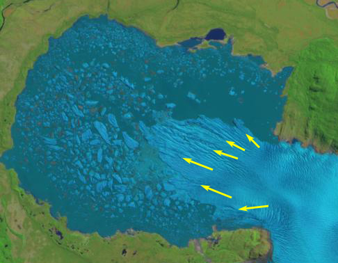
A narrow terminus tongue extending from the main terminus had an area of 0.6 km2 and extended to within ~1.5 km of  the Lake A western shore in March 2018.   By November 10, 2018 this narrow tongue had disintegrated.   In February 2020 the area of Lake A is 35.1 km2 and Lake B is 9.7 km2, a combined area of 44.8 km2 vs 20.5 km2 in 2001.  Gourlet et al (2015) examined the thickness across sections of the NPI, weather prevented the survey of the terminus area of San Quintin Glacier, but there results do hint that the bed is below sea level between Lake A and B basins, and they should connect. In the Landsat images of 2001 and 2015 a transect across the narrow point at the east end of Lake A indicates an area of 41 km2 if the entire main terminus tongue collapses. The ~24 km2 lake expansion at the two main terminus locations of San Quintin Glacier from 2001-2020 represent the fastest lake expansion from glacier retreat, is it the fastest overall for South America? Steffen Glacier is another example of rapid retreat and lake expansion. The retreat is much less than at HPS-12, but that is an example of fjord expansion.

Landsat images of San Quintin Glacier from 1987 and 2015 indicate the expansion of both Lake A and Lake B due to glacier retreat as well as retreat at Point C.

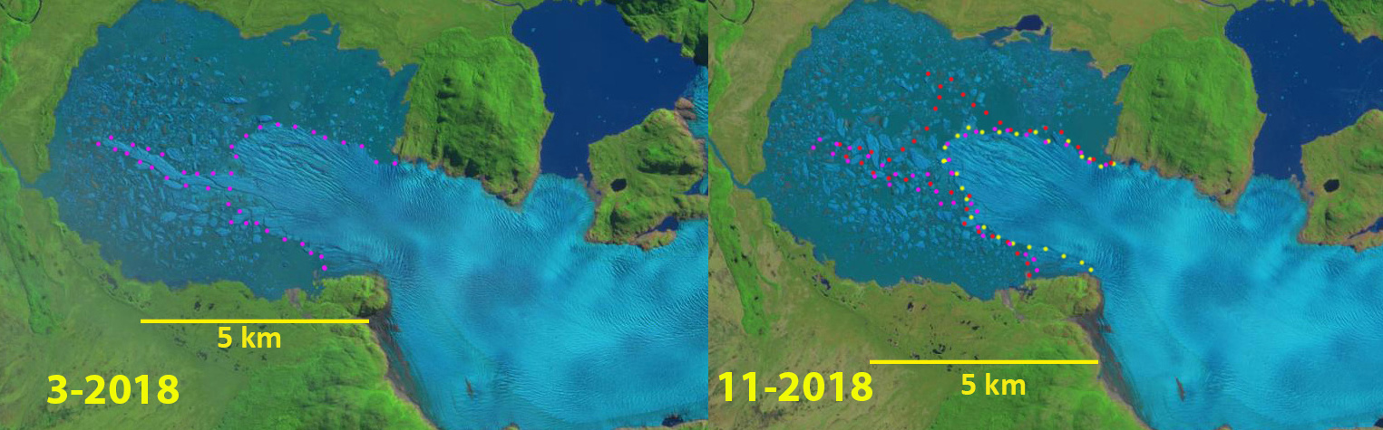
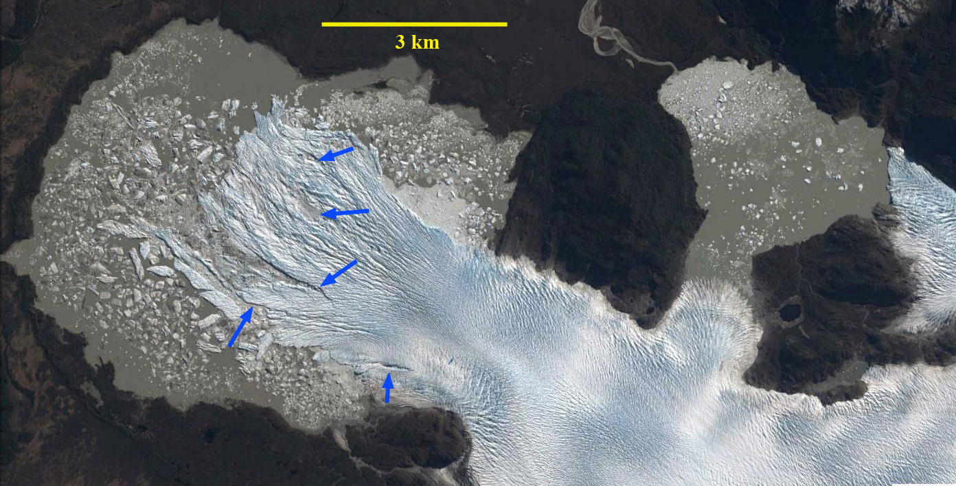
San Quintin in  March and November 2018 Landsat images indicating loss of narrow terminus tongue pink dots.

San Quintin Glacier High Calving Rate Observations in 2018

San Quintin Glacier in 4-16-2017 Sentinel image, red dots indicate terminus location then. Yellow dots the terminus location  on 11-10-2018.

San Quintin Glacier in 3-20-2018 Sentinel image, pink dots indicate terminus position. 

San Quintin Glacier in 11-10-2018 Sentinel image. Yellow dots the terminus location  on 11-10-2018, pink dots from 3-30-2018 and red dots from 4-16-2017. 

San Quintin is the largest glacier of the NPI at 790 km2 in .  The glacier extends 50 km from the ice divide in the center of the ice cap.  The peak velocity is 1100 m/year near the ELA (Rivera et al 2007), declining below 350 m/year in the terminus region.  San Quintin Glacier terminated largely on land until 1991 (Davies and Glasser, 2012). The velocity at the terminus has increased from 1987 to 2014 as the glacier has retreated into the proglacial lake (Mouginot and Rignot, 2015).  The high velocity zone extends more than 40 km inland an even greater distance than at San Rafael (Mouginot and Rignot, 2015).  Thinning rates in the ablation zone of the glacier are 2.3 m/year (Willis et al, 2012).  The glacier has a low slope rising 700 m in the first 22 km.

In 1987 it is a piedmont lobe with evident minimal marginal proglacial lake development beginning (Pelto, 2016).  Progressive retreat of the glacier into the expanding proglacial lake has led to an increasingly chaotic, disintegrating front of the glacier (Willis et al, 2012).  The large evident crevasses/rifts perpendicular to the front suggest the terminus tongue is largely afloat.  Here we examine Sentinel Images from April 2017 to November 2o18 to identify changes. NASA’s Earth Observatory has high resolution images indicating the terminus in June 2014 and April 2017

On April 16, 2017 there were four icebergs with an area greater than 0.1 kmin the San Quintin Lagoon. The narrow terminus tongue extending from the main terminus had an area of 0.6 km2 and extended to within 3.3 km of the lagoons western shore. On March 20, 2018 this tongue remains tenuously connected to the main terminus, and has extended to within 1.5 km of the western shore.  There are six icebergs with an area greater than 0.1 km2.  By November 10, 2018 this narrow tongue had disintegrated.  There are eight icebergs with an area greater than 0.1 km2.  The icebergs are slow to melt in the lagoon compared to a fjord setting. The overall terminus area loss from April 2017 to November 2018 is 1.8 to 2.0  km2. There has been additional detachment on the southern shore where the glacier enters the main lagoon basin.  This should further destabilize the glacier tongue.  In  the coming years the lagoon will continue to expand to a size of at least 40 square kilometers.

As Pelto (2017) noted 19 of the 24 main outlet glaciers of the Northern Patagonia Icefield ended in a lake in 2015, all the lake termini retreated significantly in part because of calving losses. Glasser et al (2016) observed that proglacial and ice-proximal lakes of NPI increased from 112 to 198 km2. A collapse of the terminus tongue on Steffen, Gualas and Reichert Glacier are examples.

October 31, 2018 Sentinel image indicating extensive rifts that have developed and are areas of weakness for further calving.

Landsat comparison of San Quintin Glacier in 1987 and 2015: red arrow indicates 1987 terminus location, yellow arrow indicates 2015 terminus location of the three main termini, and the purple arrow indicates upglacier thinning.


San Quintin Glacier, Chile terminus disintegration 1987-2015

san quentin compare

Landsat comparison of San Quintin Glacier in 1987 and 2015: red arrow indicates 1987 terminus location, yellow arrow indicates 2015 terminus location of the three main termini, and the purple arrow indicates upglacier thinning.

San Quintin is the largest glacier of the NPI at 790 km2 in 2001 (Rivera et al, 2007).  The glacier extends 50 km from the ice divide in the center of the ice cap.  The peak velocity is 1100 m/year near the ELA (Rivera et al 2007), declining below 350 m/year in the terminus region.  The velocity at the terminus has increased from 1987 to 2014 as the glacier has retreated into the proglacial lake (Mouginot and Rignot, 2015).  The high velocity zone extends more than 40 km inland an even greater distance than at San Rafael (Mouginot and Rignot, 2015).  Thinning rates in the ablation zone of the glacier are 2.3 m/year (Willis et al, 2012).  The glacier has a low slope rising 700 m in the first 22 km. The low slope, broad piedmont lobe and many distributary terminus lobes is like the Brady Glacier, Alaska.

Davies and Glasser (2012) note that San Quintin Glacier terminated largely on land until 1991. The glacier has lost 15 % of its area in the last century (Davies and Glasser, 2012).  The glacier has a main terminus and many subsidiary termini.  In 1987 it is a piedmont lobe with evident minimal marginal proglacial lake development beginning. There is limited lake development at the main southern and northern terminus Point C and B respectively. Harrison et al (2001) observed that in 1993 the glacier terminus was advancing strongly into vegetated ground, while from 1996 to May 2000 the glacier underwent a transition between advance and retreat.  The high rates of thinning are leading to the retreat not just of main terminus but the distributary terminus areas extending north and south into lake basins from the main glacier. From 1987 to 2015 the main terminus retreated 2200 m, almost all after 2000, largely through a disintegration of the terminus tongue in a proglacial lake.  Extensive rifting of the terminus lobe in 2013 and 2015 is still apparent in imagery below, indicating this rapid area loss is not finished.  The main lake, Point A, had an area of 23.8 square kilometers in 2011 (Loriaux and Cassasa, 2013) . The lake at Point B developing on the north side of the glacier, due to a 3500 m retreat, is now over 8 square kilometers.  The southern terminus at Point C, has a narrow fringing lake and a retreat of 1100 meters from 1987-2015. The retreat here follows the pattern of Fraenkel GlacierAcodado Glacier and Steffen Glacier to the south.

san quintin overview

Digital Globe image of San Quintin Glacier in 2011.

san quintin terminus 2013

2013 Google Earth image, with the large rifts indicating glacier weakness noted with blue arrows. 

san quintin terminus 2015

2015 Landsat image, yellow line indicates terminus. Note the tongue is surrounded on three sides by water.