Grace, Lucas and Price Glacier Retreat from Tidewater, South Georgia Island 1987-2024

Grace (G), Lucas (L) and Price (P) Glacier’s in 4-6-2024 Sentinel image top, yellow dots mark the 1987 terminus position when all reached tidewater, blue dots indicate 2024 terminus. Below is the South Georgia GIS with terminus observations from the BAS shown.

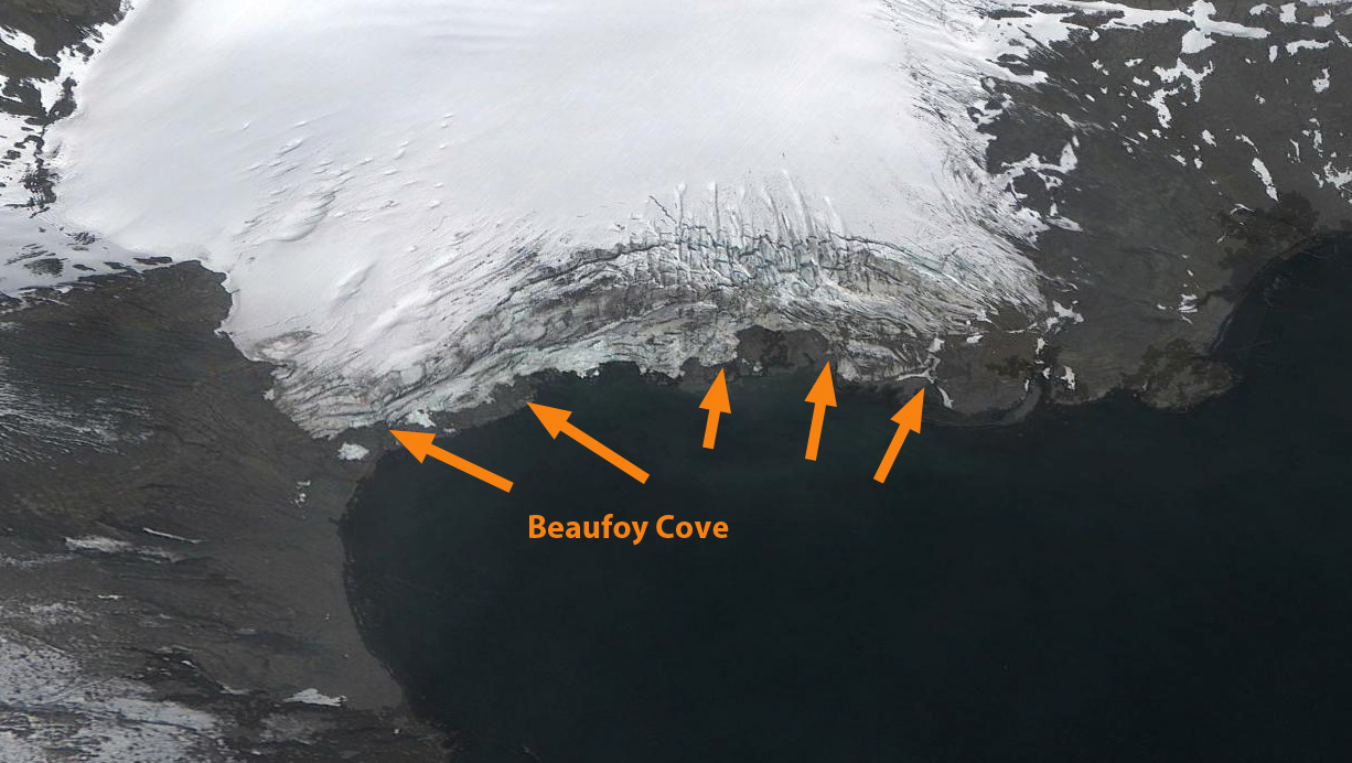
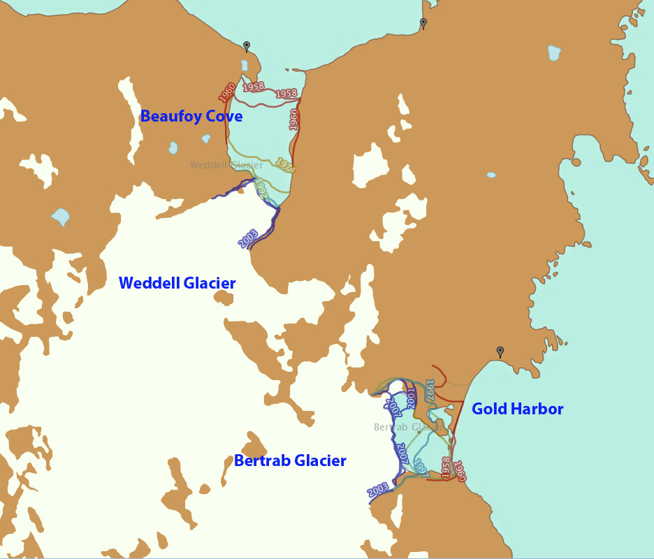
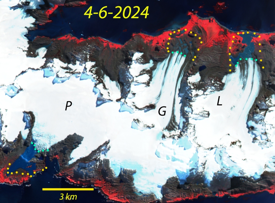
In 1987 Grace, Lucas and Price Glacier on the northern end of South Georgia Island each reached tidewater. Each had retreated less than 100 m since 1976. This is a very cloudy region and clear satellite image views limited. Here we examine Landsat images from 2000 and 2016, and a Sentinel image from 2024 to identify changes.  Gordon et al., (2008) observed that larger tidewater and sea-calving valley and outlet glaciers generally remained in relatively advanced positions until the 1980’s.  After 1980 most glaciers receded; many of these retreats have been dramatic including Twitcher, Herz, Ross, Hindle, Konig and Neumayer Glacier (Pelto, 2017).  

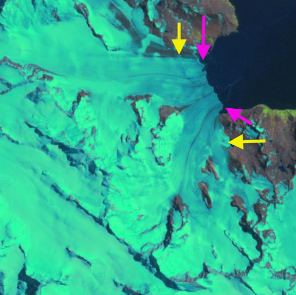
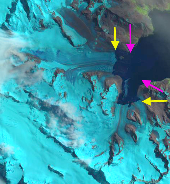
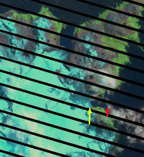
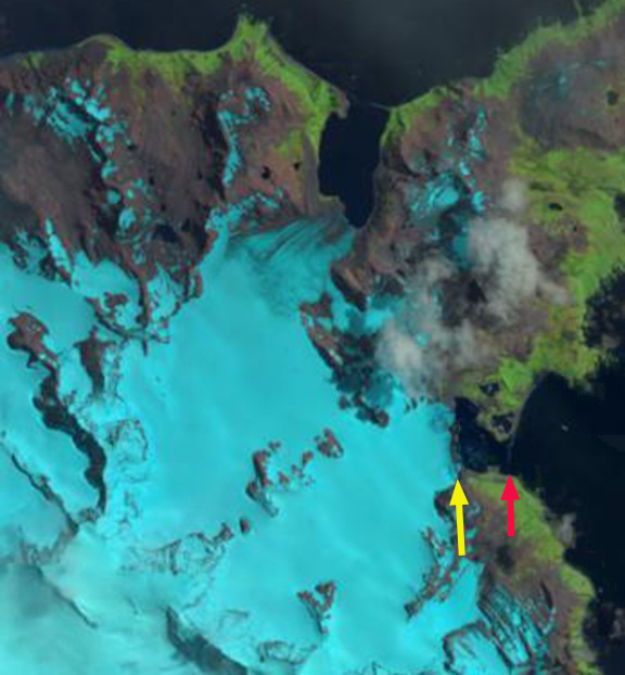
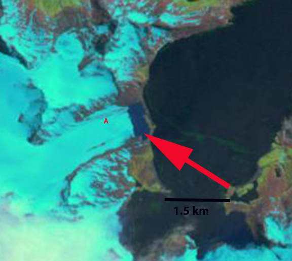
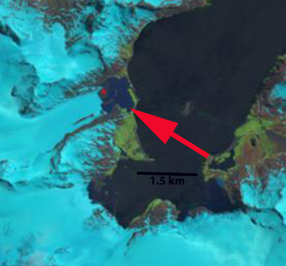
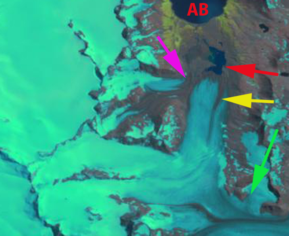
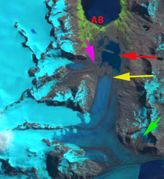
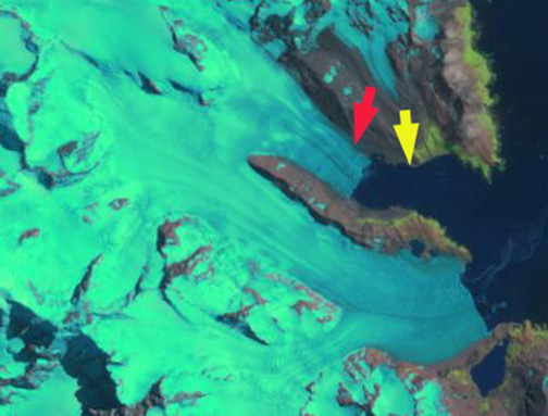
By 2002 a Landsat image reveals that Grace and Lucas Glacier have retreated from the coast with new proglacial lakes forming between the terminus and the coast. Price Glacier main terminus is still filling most of a narrow bay, and the east side of the terminus is still reachig the coast. By 2016 Grace Glacier retreat has led to the formation of several small proglacial alkes, while Lucas Glacier retreat has generated one larger proglacial lake. Price Glacier has begun to retreat up a narrow embayment and the east side has almost lost connection with tidewater.

In 2024 Grace Glacier has retreated 1200 m, ~20% of its length in 1987. Lucas Glacier has retreated 1400 m, ~20% of its length. Price Glacier now only terminates in a narrow embayment ,has retreated 1700 m, ~23% of its length. Each glacier has limited area above 500 m, indicating that below this elevation glacier mass balance has been significantly negative over the last 35 years. The retreat here is similar to that of Konig and Turnback that have retreated from tidewater exposing new coastal regions that are being occupied by flora and fauna.

Grace (G), Lucas (L) and Price (P) Glaciers in 2002 and 2016 Landsat images as they retreat from tidewater.

Hindle Glacier Retreat, South Georgia 2 km 2015-2019

Hindle Glacier comparison in 2017 and 2019 Landsat images.  Red arrow is 1989 terminus, pink arrow the 2015 terminus, yellow arrow the 2017 terminus location and green arrow the 2019 terminus location. 

South Georgia is south of the Polar Front preventing any truly warm season, with the cool maritime climate leading to numerous glaciers covering a majority of the island.  Hindle Glacier enters Royal Bay on the east coast of South Georgia Island.  The British Antarctic Survey (BAS) has been the principal research group examining glacier change on South Georgia Island.  Cook et al (2010) and Gordon et al (2008) noted a pattern island wide with many calving glaciers having the fastest retreat.  Gordon et al., (2008) observed that larger tidewater glaciers remained in relatively advanced positions from the 1950’s until the 1980’s, followed by significant recession.   Alison Cook at British Antarctic Survey identified that 212 of the Peninsula’s 244 marine glaciers have retreated over the past 50 years and rates of retreat are increasing.   In 2017 we examined Landsat imagery from 1989 to 2017 to identify the rapid retreat rate.  NASA Earth  piggy backed on this assessment, with excellent imagery, since the retreat rate has increased. Here we update the retreat with 2019 Landsat images.

For Ross-Hindle the retreat was minimal from 1960 to 1989 with the glaciers joined   In 1989 the glaciers joined 2.5  km from the terminus. The glacier spanned Royal Bay with a 3.2 km wide calving front.  By 2002 the glacier front had retreated 800 m, but they were still joined. By 2008 the glaciers had separated due to an additional retreat of  1.4 km. The front was now retreating south up a separate embayment from Ross Glacier.  The calving front in 2008 was 1.6 km wide.  By 2015 further retreat led to the separation of Hindle from an eastern tributary at the first prominent headland in the fjord, a 1.6 km retreat in seven years.  By 2017 an additional 600 m of retreat had occurred.  From 2017 to 2019 the terminus retreated another 1.5 km back to a prominent rock knob separating the two main tributaries of the glacier with total retreat of  6.1 km in 30 years. This is a rate of over 200 m/year, which is an exceptional rate.  Over the 2015-2019 period the glacier retreaeted over 2 km, more than 500 m/year. The western tributary appears to be at the head of the fjord, while the eastern tributary has another 1 km to an increase in slopes that likely is close to head of the fjord. The new fjord is 4.5 km long and averages 1.1 km in width.  This embayment will open up new areas for Gentoo Penguins and elephant seals to immigrate into.  Levy et al (2016) discuss the shift and dispersal of colonies in the region, that climate change is an important driver of.

Map of terminus retreat of Ross and Hindle Glacier from the BAS.  Green Pin Locations are Gentoo Penguin colonies. 

Hindle Glacier comparison in 1989 and 2015 Landsat images.  Red arrow is 1989 terminus, pink arrow the 2015 terminus, yellow arrow the 2017 terminus location and green arrow the 2019 terminus location. 


Ryan Glacier, South Georgia Retreats from Tidewater

Ryan (R) and Brunonia Glacier (B) in 1999 and 2016 Landsat images.  Red arrows indicate the 1999 terminus and pink arrows a new proglacial lake. 

Ryan Glacier and Bunonia Glacier span the width of South Georgia near its northwestern tip.  Brunonia Glacier flow east and terminates in Sunset Fjord and Ryan Glacier flows to the west into Ice Fjord, which seems more viable as a “Sunset” Fjord.  The glacier divide is a very low 400 m.  The British Antarctic Survey (BAS) has generated an excellent online map of South Georgia that includes many layers including glacier frontal change since 1958 in this region.  BAS work by Cook et al (2010) and Gordon et al (2008) have emphasized that there is a island wide pattern of calving glaciers having faster retreat.  Gordon et al., (2008) observed that larger tidewater and calving outlet glaciers generally remained in relatively advanced positions from the 1950’s until the 1980’s. After 1980 most glaciers receded; some of these retreats have been dramatic a such as Hindle and Neumayer.   Here we examine 1999-2016 Landsat imagery to identify glacier change. 

In 1999 Ryan Glacier reaches tidewater across a 1.2 km glacier front.  Brunonia Glacier terminates in Sunset Fjord pinned on what is a bedrock prominence under the ice. In 2013 and 2015 Landsat imagery from early in the melt season indicates the melt zone is below 200 m. In 2015 it is evident that Ryan Glacier no longer reaches tidewater.  In 2016 Ryan Glacier is separated from Ice Fjord by a barrier beach and a narrow developing proglacial lake, pink arrow.  The glacier has retreated 200 m since 1999.  Brunonia Glacier has experienced a 400 m retreat exposing 2 new peninsulas.  The first is on the north side of the fjord and the other is mid glacier. Both had been under the ice in 1999. The snowline in 2016 on Ryan Glacier is also higher reaching 250 m in mid-February.  Retreat of Ryan Glacier from 1958 to 1999 was 100 m, while the retreat on Brunonia in the same period was 700-800 m.

British Antarctic Survey map of frontal change 1958-2015.

Ryan and Brunonia Glacier in 2013 and 2015 Landsat images. The 2015 image indicates Ryan Glacier is no longer tidewater. 


Hindle Glacier Rapid Retreat Continues, South Georgia

Hindle Glacier comparison in 1989, 2015 and 2017 Landsat images.  Red arrow is 1989 terminus, pink arrow the 2015 terminus and red arrow the 2017 terminus location. 

South Georgia is south of the Polar Front preventing any truly warm season from persisting. The cool maritime climate leads to numerous glaciers covering a majority of the island and quite low equilibrium line altitudes.  Hindle Glacier enters Royal Bay on the east coast of South Georgia Island.  The British Antarctic Survey (BAS) has been the principal research group examining glacier change on South Georgia Island.  Cook et al (2010) and Gordon et al (2008) have emphasized that there is a pattern island wide with many calving glaciers having faster retreat.  Gordon et al., (2008) observed that larger tidewater and calving outlet glaciers generally remained in relatively advanced positions from the 1950’s until the 1980s. After 1980 most glaciers receded; some of these retreats have been dramatic and a number of small mountain glaciers will soon disappear.   The change in glacier termini position have been documented by Alison Cook at British Antarctic Survey in a BAS retreat map, she identified that 212 of the Peninsula’s 244 marine glaciers have retreated over the past 50 years and rates of retreat are increasing.   Here we examine Landsat imagery from 1989 to 2017 to identify the rapid retreat rate. NASA Earth has piggy backed on this assessment, with excellent imagery.

For Ross-Hindle the retreat was minimal from 1960 to 1989 with the glaciers joined   In 1989 the glaciers joined 2.5  km from the terminus. The glacier spanned Royal Bay with a 3.2 km wide calving front.  By 2002 the glacier front had retreated 800 m, but they were still joined. By 2008 the glaciers had separated due to an additional retreat of  1.4 km. The front was now retreating south up a separate embayment from Ross Glacier.  The calving front in 2008 was 1.6 km wide.  By 2015 further retreat led to the separation of Hindle from an eastern Tributary at the first prominent headland in the fjord, a 1.6 km retreat in seven years.  By 2017 an additional 600 m of retreat had occurred with total retreat of  4.4 km in 28 years.  This is a rate of over 150 m/year, which is an exceptional rate.  The exceptional retreat rate of Hindle Glacier suggests that Ross Glacier acted as a pinning point stabilizing the terminus reach of the glacier.  The low surface slopes in 2017 for the lowest 3 km of the glacier suggest the fjord head is at least 3 km south of the present terminus and  the calving retreat will continue until the head of the fjord is reached. This location is close to the origin of the medial moraine that runs right to the glacier front currently. This embayment will open up new areas for Gentoo Penguins and elephant seals to immigrate into.  Levy et al (2016) discuss the shift and dispersal of colonies in the region, that climate change is an important driver of.

Map of terminus retreat of Ross and Hindle Glacier from the BAS.  Green Pin Locations are Gentoo Penguin colonies. 

2002 Landsat image of Hindle Glacier.  Red arrow is 1989 terminus and yellow arrow the 2017 terminus location. 

Hindle Glacier 2016 Landsat image.  Red arrow is 1989 terminus and red arrow the 2017 terminus location. 

Location of South Georgia versus atmospheric and ocean circulation features (From South Georgia Future Science). 

Neumayer Glacier, South Georgia, 5.6 km retreat 1999-2016


neumayer 2016

Comparison of Neumayer Glacier in 1999 and 2016 Landsat images; red arrow indicates 1999 terminus locations, yellow arrows 2016 terminus locations. Purple arrows indicate upglacier thinning.

South Georgia sits amidst the circum Antarctic westerlies and its maritime climate leads to numerous glaciers. This region is famous for the endless march of storms parading around Antarctica . The island is south of the Antarctic Convergence, preventing any truly warm season from persisting. The cool glaciers covering a majority of the island and quite low equilibrium line altitudes. Neumayer Glacier is one of the largest tidewater glaciers on South Georgia. Sugden, Clapperton and Pelto (1989) noted the ELA of Neumayer Glacier at 550 m.

The BAS has a mapping function that provides glacier front positions since early in the 20th century. For Neumayer Glacier the 1938 position is 3.5 km down fjord from the 2006 position. There was essentially no retreat up to 1974 and limited retreat up to 1993. Gordon et al., (2008) observed that larger tidewater and sea-calving valley and outlet glaciers generally remained in relatively advanced positions until the 1980s. After 1980 most glaciers receded; some of these retreats have been dramatic.

Landsat Images from 1999 to 2016 indicates retreat of 5600 m from the red to the yellow arrow, this is 350 m/year. A glacier dammed lake along the north shore of the fjord no longer exists in 2016. The glacier appears to have retreated into a deeper section of the fjord then where it ended from 1970-2002. The glacier is on the verge of separation into two main tributaries. This will enhance calving from the glacier, and promote additional mass loss and retreat. This retreat will impact Konig Glacier to the north, which is connected to the Neumayer Glacier. Below the comparison of terminus location from 1989 to 2015 indicates a retreat of 6700 m.  NASA Earth has piggy backed on this assessment, with excellent recent imagery. Calving rate increases with water depth.  Calving rate increases with water depth and the degree of glacier flotation. Flotation depends on water depth, ice thickness and the number of pinning points. Pelto and Warren (1991) provided an expanded version of the water depth/calving relationship first quantified by Brown and others (1982). In the you would have never guessed it category, is the glacier retreat has been an aid to the rat population, as the glacier tongues used to corner populations.

BAS Glacier front map

neumayer compare

Comparison of Neumayer Glacier in 1989 and 2015 Landsat images; red arrow indicates 1989 terminus locations, yellow arrows 2015 terminus locations.


Hindle Glacier, Accelerating Retreat, South Georgia

hindle 89-15

Landsat Image of Ross Hindle Glacier 1989 left and 2015 right.  Something changed.

South Georgia sits amidst the furious if not screaming fifties latitude belt, the circum Antarctic westerlies. This region is famous for the endless march of storms parading around Antarctica. The island is south of the Antarctic Convergence, preventing any truly warm season from persisting. The cool maritime climate leads to numerous glaciers covering a majority of the island and quite low equilibrium line altitudes.  Ross-Hindle Glacier enters Royal Bay on the east coast of South Georgia Island has now separated into the Ross and Hindle Glaciers. Hindle Glacier could do well  in a new international Olympic event, “Fastest Retreating Glacier” The tidewater glaciers of South Georgia in general maintained fairly advanced positions unitl 1980. Gordon et al., (2008) observed that larger tidewater and sea-calving valley and outlet glaciers generally remained in relatively advanced positions until the 1980s. For Ross-Hindle the retreat was minimal from 1960 to 1989. The change in glacier termini position have been documented by Alison Cook at British Antarctic Survey in a BAS retreat map.  By 2008 the glaciers had separated. Here we examine Landsat imagery from 1989 to 2015 to identify recent change.

hindle area2

Region of Hindle Glacier on South Georgia.

BAS map of glacier front change.

In 1989 the glacier extends to the green arrows with a joint terminus that is three kilometers long. This is quite close to the 1960 terminus location. By 2003 the glacier has retreated  800 m with the south side nearly reaching a Point where the Hindle Glacier turns south  By 2008 the glaciers have separated, with a further retreat  of 1.5 km along the southern margin of Ross Glacier and western margin of Hindle Glacier. Retreat is much less on the northern side of Ross Glacier and the eastern side of Hindle Glacier.  By 2015 a new fjord has opened, as Hindle Glacier retreats south 1.7 km on the east margin and 2.1 km on the west side in just seven years.Ross Glacier continues to retreat west with a retreat of 600-700 m since 2008.

In Google Earth by 2010 there is  added crevassing near the ice front of Hindle Glacier that indicates an acceleration of the glacier. This suggests the Ross Glacier was impeding its flow previously and that Hindle is in a rapid retreat mode.The rapid recent retreat parallels that of Neumayer Glacier and Twitcher Glacier during the 1989-2014 period. The BAS research effort on glacier front retreat has been documented by Alison Cook . Her comparison of glacier fronts from old aerial photographs and comparing them with satellite images — she identified that 212 of the Peninsula’s 244 marine glaciers have retreated over the past 50 years and that rates of retreat are increasing.

hindle 1989

1989 Landsat Image

ross hindle 2003

2003 Landsat Image


2008 Landsat Image

ross Hindle 2015

2015 Landsat Image


Weddel Glacier Thinning-Retreat, South Georgia Island

Weddel Glacier is on the southeast coast of South Georgia Island.  It terminates in Beaufoy Cove just north of Gold Harbor.The change in glacier terminus position has been documented by Alison Cook at British Antarctic Survey in a BAS retreat map.  In 1958 it reached within 400 m of the coast at the outlet of Beaufoy Cove. Gordon et al., (2008) observed that larger tidewater and sea-calving valley and outlet glaciers generally remained in relatively advanced positions until the 1980s. For Weddel Glacier the retreat was rapid from 1960 to 1974 and was slow from 1992-2003.  Here we examine Landsat imagery from 1989 to 2015 to visualize and update this change.
bertrab ge
Google Earth Image

weddell-bertrab map
BAS map of glacier terminus position

In 1989 the glacier terminates near the tip of a peninsula, red arrow in each image. The calving front extends southeast, orange dots. At the yellow arrow the glacier fills a small side valley adjacent to the main glacier. At the purple arrow is a small extension of the main icefall flowing down the bedrock step.
In 2002 there is only minor retreat at the red and yellow arrow, but thinning has led to the small extension of the main icefall being almost cutoff by bedrock. By 2015 the glacier has retreated 200-300 meters from the 1989 position and the main terminus is narrower. At the yellow arrow the side valley no longer has ice. At the purple arrow this is just bedrock now, there is no glacier extension flowing down the bedrock step. A close up the icefall in a 2009 Google Earth image indicates both the extensive crevassing but also the lack of glacier ice at the purple arrow, where an extension of the icefall formerly flowed. A Google Earth closeup of the terminus indicates that only a small section is still in contact with Beaufoy Cove in 2009, with land exposed at the orange arrows. This glacier is almost not tidewater and has terminated in shallow water since 1989, which helps explain a slower rate of retreat. The glacier has thinned more rapidly than it has retreated in the last 25 years. The retreat rate is less than nearby Bertrab Glacier, Konig Glacier and Neumayer Glacier on the same coast of South Georgia.

weddel glacier 1989

Landsat Image 1989

weddell glacier 2002

Landsat image 2002

weddel glacier 2015
Landsat image 2015

weddel icefall
Google Earth icefall image
weddel terminus
Google Earth 2009 image

Bertrab Glacier Retreat, South Georgia Island

Bertrab Glacier is on the east coast of South Georgia Island.  The change in glacier terminus position has been documented by Alison Cook at British Antarctic Survey in a BAS retreat map.  In 1958 it reached the coast in Gold Harbor. Gordon et al., (2008) observed that larger tidewater and sea-calving valley and outlet glaciers generally remained in relatively advanced positions until the 1980s. For Bertrab Glacier the retreat was minimal from 1958 to 1989. Since 1989 a whole new embayment has opened.  Here we examine Landsat imagery from 1989 to 2015 to visualize and update this change.

weddell-bertrab map

BAS Glacier Front map 1958-2007.

bertrab ge

Google Earth image

In 1989 the southern arm of the glacier extends to the shoreline of the barrier beach system in Gold harbor, Red arrow. The northern arm extends around to the edge of a very green region, suggesting well developed vegetation, hence no real retreat for sometime.  By 2002 a lake has formed at the northern arm terminus and it has retreated 400 m.  The southern arm has retreated across a new embayment ending near the yellow arrow, though the exact position is obscured by cloud.  In 2011 the southern terminus has retreated up a slope from the edge of the embayment, yellow arrow.  In 2015 there are no longer two arms to the glacier.  The glacier terminates near the edge of the new embayment. The retreat is 700 m on the northern arm and 1000 m for the southern end since 1989.  The glacier no longer reaches the water limiting calving.  The glacier also ends on moderate slope.  This should lead to a reduced retreat in the near future.  The 2015 picture is from Jan.15, so there is still two months left in the melt season. The retreat is similar to that of Ross Hindle Glacier , Konig Glacier and Neumayer Glacier on the same coast of South Georgia, and faster than for neighboring Weddel Glacier.  Like on Stephenson Glacier, Heard Island the new embayment does offer new potential habitat for penguins and seals.

bertrab glacier 1989

1989 Landsat image
bertrab glacier 2002

2002 Landsat image

bertrab glacier 2011

2011 Landsat image

bertrab glacier 2015

2015 landsat image

Purvis Glacier Retreat, South Georgia Island

Purvis Glacier is on the norteastern coast of the island, terminating on land near Possession Bay. The British Antarctic Survey (BAS) has mapped many aspects of the island including glacier front changes. Their mapping indicated below shows that the Purvis Glacier terminus was on the coastline in 1974. Here we examine Landsat imagery from 1999 to 2014 to identify more recent changes. Cook et al (2010) quantified the change in these maps noting that 97% of the 102 coastal glacier retreated between the 1950’s and today.
purvis glacier map
BAS map of Glacier change.

purvis ge
Google Earth image

In 1999 the proglacial lake, red arrow, that the glacier terminated in was 300 m wide, indicating a retreat of 300-400 m since 1974. By 2002 the proglacial lake had expanded to a width of 600 m, exposing a peninsula at Point A. By 2013 the proglacial lake had expanded to 1050 m, further exposing the peninsula at Point A. By March 1, 2014 Landsat imagery indicates a retreat of 1100 m since 1974, with most of that retreat occurring since 1979. A closer look at the glacier from Google Earth highlights the issue. The glacier is fed by relatively low lying snowfields with quite limited areas above 500 m. Sugden, Clapperton and I in a 1989 paper identified the snowline a short distance from here at 400 to 450 m. As the 2011 Google Earth image indicates the remaining snowcover at the end of the melt season is minimal, too little to sustain this glacier (Pelto, 2010). Further a look at the terminus indicates the stagnant nature of the terminus region that will lead to continued retreat, blue arrows note ablation holes in the glacier that do not develop when a glacier is actively moving. The low slope and stagnant nature should preserve an excellent glacial geologic landscape.

The glacier is behaving in the same fashion as other land terminating glaciers Heaney Glacier and Konig Glacier. The retreat is less than that of calving glaciers on the island Neumayer Glacier and Ross-Hindle Glacier.
purvis glacier 1999
1999 Landsat image

purvis glacier 2002
2002 Landsat image

purvis glacier 2013
2013 Landsat image

purvis glacier 2014
2014 Landsat image

purvis glacier terminus
Google Earth image

Konig Glacier Retreat, South Georgia Island

Konig Glacier is a land terminating glacier just north of the Neumayer Glacier, ending on an outwash plain in the Antarctic Bay (AB) on the northwest coast of South Georgia. In 1977 the glacier extended to within 300 m of Antarcic Bay and no proglacial lake existed (BAS map). Neumayer Glacier is a calving glacier that has retreated 4800 m from 1999 to 2014 and is dynamically connected to the Konig Glacier along its southern margin just where the glacier turns northeast. Gordon et al., (2008) observed that larger tidewater and sea-calving valley and outlet glaciers generally remained in relatively advanced positions until the 1980s. After 1980 most glaciers receded; some of these retreats have been dramatic and a number of small mountain glaciers will soon disappear. konig glacier ge Here we examine changes in Konig Glacier from 1999 to 2014 using Landsat imagery. In 1999 the glacier ended in a proglacial lake at the red arrow, where a terminal moraine developed across the lake. A tributary glacier from the west joins the Konig Glacier near the terminus in 1999, pink arrow. At the green arrow is a small cirque-valley glacier that joins the Neumayer Glacier near the boundary with Konig Glacier. In 2003 there has been limited retreat of the main terminus since 1999 and of the west tributary at the pink arrow, the British Antarctic Survey mapping shows that the two glacier had separated by 2003. The side cirque glacier at the green arrow is still connected. By 2005 a closeup of the terminus in Google earth indicates the low slope, lack of crevasses and developing outwash plain at the terminus. The terminal moraine in the middle of the lake marking the 1993 terminus position is also evident (BAS). The retreat from this moraine by 2005 is 500m. In 2014 the glacier has retreated from to the yellow arrow, this is an 800 m retreat in 15 years from the 1999 red arrow terminus. The proglacial lake is now 1500 m across and the terminus is 2300 m from Antarctic Bay. The west gtributary at the pink arrow is fully separated. The side cirque glacier at the green arrow no longer is connected to the Konig-Neumayer Glacier. This indicates considerable thinning of the junction of these two glaciers which will result in further retreat of Konig Glacier.
konig glacier 1999
1999 Landsat image
konig glacier 2003
2003 Landsat image

konig terminus
Google earth image 2005

konig glacier 2014
2014 Landsat image

Herz Glacier Retreat, South Georgia

Herz Glacier is on the southeast coast of South Georgia Island. The terminus change of this tidewater glacier ending in Iris Bay was completed by the British Antarctic Survey for the 1960-2007 period (Gordon et al, 2008). The map below indicates the slow retreat from 1960-1988 and a more rapid retreat since.harz glacier map Here we examine imagery from Google Earth and Landsat to examine terminus change from 1989-2010. In each image the red arrow indicates the location of the terminus in 2009-2010 the yellow arrow the 1989 terminus position. The first image is the Google Earth image from 2010, followed by the 1989, 2000 and 2009 Landsat images. The terminus on the north side of the fjord has retreated 1.8 km in the 20 year period and the terminus on the south side has retreat 2.2 km. The overall 2 km retreat is a rate of 100 meters/year and is 20 % of the total glacier length. This is an exceedingly cloudy region and imagery from 2011 and 2012 does not provide a clear observation of the terminus. The retreat of this glacier is less dramatic than that of Neumayer Glacier or Ross Hindle Glacier further north on the coast.herz glacier ge

harz glacier 1989

harz glacier 2000

harz glacier 2009

Ross Hindle Glacier Separation and Retreat, South Georgia

The Ross-Hindle Glacier enters Royal Bay on the east coast of South Georgia Island has now separated into the Ross and Hindle Glaciers. In a 2003 Landsat image the glaciers are joined, as they had been for quite some time. By 2008 the glaciers had separated. The tidewater glaciers of South Georgia in general maintained fairly advanced positions unitl 1980. Gordon et al., (2008) observed that larger tidewater and sea-calving valley and outlet glaciers generally remained in relatively advanced positions until the 1980s. For Ross-Hindle the retreat was minimal from 1960 to 1989. The change in glacier termini position have been documented by Alison Cook at British Antarctic Survey in a BAS retreat map The sequence of annotated Landsat images below indicates the retreat and separation from 2003 top, to 2008 and then 2010. Hindle Glacier front is noted with red arrow, Ross Glacier green arrow, V marks the location of the ridge at the beginning of their juncture. The retreat of Ross Glacier ranges from meters on the north shore to meters on the south side. The Hindle Glacier has retreated 1.5-2.1 km in this period. By 2008 the glaciers have separated, by 2010 a new bay has formed at the front of Hindle Glacier. The new bay is evident, note yellow arrow. This leads to the strange juxtaposition in Google Earth of the 2003 image front for Ross Glacier and the 2010 image front for Hindle Glacier. Further added crrevassing near the ice front indicates an acceleration of the Hindle Glacier. This suggests the Ross Glacier was impeding its flow previously and that Hindle is in a rapid retreat mode. The rapid recent retreat parallels that of Neumayer Glacier further up the coast. The BAS research effort on glacier front retreat has been documented by Alison Cook . Her comparison of glacier fronts from old aerial photographs and comparing them with satellite images — she identified that 212 of the Peninsula’s 244 marine glaciers have retreated over the past 50 years and that rates of retreat are increasing.