Dickson Glacier, Argentina/Chile Retreat, Separation &Lake Opening

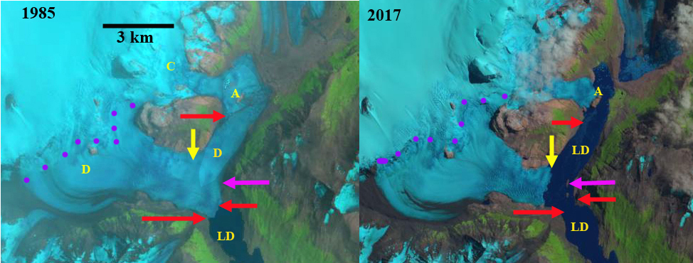
Dickson Glacier (D) retreat illustrated by 1985 and 2017 Landsat images. Red arrows the 1985 terminus position, yellow arrows the 2017 terminus position, C=Cubo Glacier, A=Island, pink arrow indicates where islands form, purple dots indicate snowline and LD=Lago Dickson.

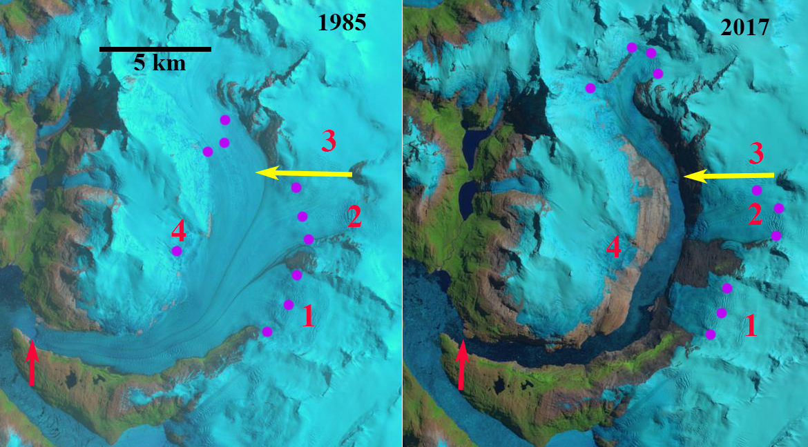
Dickson Glacier is located in Southern Patagonian Icefield (SPI) in Torres del Paine National Park straddling the Argentina and Chile border.  The glacier in 1985 had both an eastern and southern terminus, the southern terminus was in Lago Dickson and the eastern terminus merged with Cubo Glacier (C). From 1986 to 1998, the glacier retreated on both fronts, the Lago Dickson in 1998 was same elevation as the newly forming glacier lake between Dickson and Cubo Glacier (Rivera et al, 2004).  In 1999 the lakes joined and in a bold voyage Andrés Rivera and Heiner Lange crossed by boat from Lago Dickson through the narrow channel in front of Dickson Glacier into the upper lake.  Between 1999 and 2003 Rivera et al (2004) notes that the Dickson Glacier front was relatively stable partly due to the appearance of rocks at the base of the front, see image below.  Here we examine the changes from 1985 to 2017 using Landsat imagery.

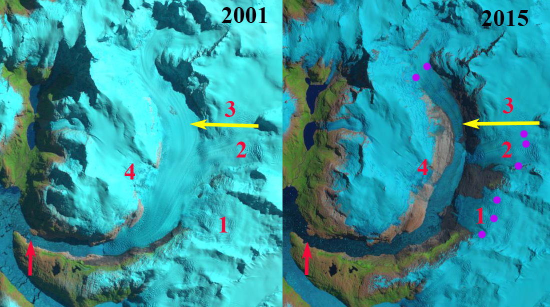
In 1985 Dickson Glacier descends from the icefield with the eastern margin merging at a lateral moraine with Cubo Glacier.  The southern terminus extends to the bend in the Lago Dickson basin with a 1.5 km wide calving front. By 2000 the eastern terminus had separated from Cubo Glacier, retreating 1.5 km from Cubo Glacier. This led to the expansion of Lago Dickson and connection to the main lake.  Cubo Glacier terminates on a bedrock island in 2000, Point A, with a small lobe going north and beyond this island.  The southern terminus has retreated and terminates on two islands, pink arrow.  The islands acted as stabilizing points for the southern terminus up to 2010. This kept the width of the lake connection at 250-300m.  By 2016 the eastern terminus had retreated to the Dickson Glacier valley extending NW  to the SPI. Cubo Glacier still terminates at the Island, Point A, but the northern lobe is now gone.  The southern terminus has retreated from the bedrock islands, pink arrow.  In 2016 the southern terminus had a narrow tongue extending almost to the islands, pink arrow.  By 2017 this unstable terminus tongue had disintegrated and the terminus of Dickson Glacier is now a single 1.6 km wide front across the mouth of the NW trending valley to the SPI. The eastern terminus has retreated 2.9 km since 1985 and the southern terminus has retreated 1 km since 1985. Lago Dickson had a length of 11 km in 1985 and in 2017 is 15 km long.  The Dickson Glacier has lost most of its low elevation terminus lobe, which will reduce ablation.  The calving front overall length had declined leading to less calving losses.  Both factors should lead to a reduced rate of retreat in the near future.  Cubo Glacier remains pinned on the island at Point A, retreat from this spot will lead to further expansion of Lago Dickson. The retreat of this glacier follows the pattern of other glaciers on the east side of the SPI Olvidado Glacier,  Onelli Glacier and Grey Glacier

.

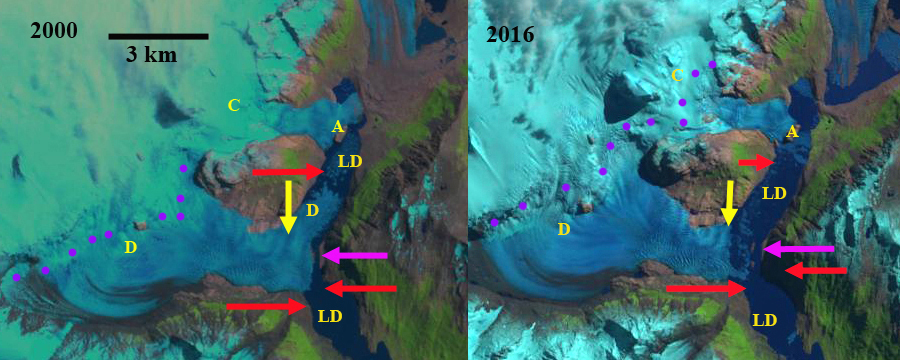
Dickson Glacier (D) retreat illustrated by 2000 and 2016 Landsat images. Red arrows the 1985 terminus position, yellow arrows the 2017 terminus position, C=Cubo Glacier, A=Island, pink arrow indicates where islands will form, purple dots indicate snowline and LD=Lago Dickson.

Map of terminus change of Dickson, Cubo and Frias Glacier from Rivera et al (2004)

HPS-12, Chile Spectacular 13 km retreat 1985-2017

HPS-12 Glacier in 1985 and 2017 Landsat images.  The red arrow indicates 1985 terminus, yellow arrows the 2017 terminus, purple dots the snowline and 1-4 are tributaries.  By 2017 all tributaries have detached and the glacier has retreated 13 km. 

HPS-12 is an unnamed glacier draining the west side of the Southern Patagonia Ice Cap (SPI).  The glacier terminates in a fjord and is adjacent to Upsala Glacier to the east and Pio IX Glacier to the north. This developing fjord is also unnamed but feeds into Estero Falcon. The glaciers of the SPI have been experiencing significant mass loss and overall retreat. Willis et al (2012) observed significant mass loss from 2000-2012 of −20.0  Gt per year.  Willis et al (2012) indicate in Fig.1 that the majority of the ice cap has thinned during this period from 2-10 m, with the greatest thinning being in the lower portion of HPS-12. Schaefer et al (2015) indicate and ELA of 980 m and a calving velocity of 2290 m per year, which is quite high for this size of glacier.  Here we examine the retreat and fjord opening using Landsat imagery from 1985-2017.  Is it the fastest retreating glacier in Chile in the last three decades? 

 In 1985 the HPS-12 terminates 1.5 km from the junction of two fjords that are occupied by HSP-12 and HSP-13.  These are separated by a peninsula.  The glacier is fed by four tributaries labelled 1-4. The snowline in 1985 is at 900 m.  In 2001 the four tributaries still join the main glacier, but the terminus has retreated 3.5 km.  In 2015 glacier retreat has led to separation of tributary 1, 2 and 4 from the main glacier, tributary 3 only feeds tributary 2 and not the main glacier.   The snowline in mid-January of 2015 is at 950 m.  The glacier retreat has continued to 2017, the current terminus is 800 m wide vesus 2800 m wide in 1985 at this location.  total retreat from 1985 to 2017 is 13 km.  The fjord is now nearly 15 km long.  HPS-12 was 26 km long in 1985 and is now less than  13 km long, it is 1/2 gone in three decades. This retreat along with Jorge Montt is the largest in Chile in the last 30 years. The retreat fits the pattern of large retreats of calving outlet glaciers of SPI such as Onelli Glacier, Bernardo Glacier and Lucia Glacier.

We also have a unique laboratory to examine a pristine fjord just created an the aquatic ecologic succession and physical oceanographic transitions that will occur. 

HPS-12 Glacier in 2001 and 2015 Landsat images.  The red arrow indicates 1985 terminus, yellow arrows the 2017 terminus, purple dots the snowline and 1-4 are tributaries.  By 2015 all tributaries have detached. 

HPS-12 in 2015 Digital Globe image. Red dots indicate 1985 terminus and yellow dots 2015 terminus location for main glacier and tributaries. 


Gabriel Quiroz Glacier, Chile Retreat Forms New Lake

Gabriel Quiroz Glacier, Chile in 1987 and 2016 Landsat images illustrates the retreat.  Red arrow is 1987 terminus, yellow arrow the 2016 terminus, purple arrow a retreating northern tributary and purpe dots the snowline.

Gabriel Quiroz Glacier is a northern outlet glacier of the Southern Patagonia Icefield that drains into the Rio Pascua.  The glacier in 1987 terminated within 250 m of Lago Gabriel Quiroz.  Willis et al (2012) observed that between February 2000 and March 2012 that the Southern Patagonia Icefield is rapidly losing volume and that thinning extends even to high elevations.  The overall retreat has been driven by increasing calving rates from the 1975-2000 to the 2000-10 period (Schaefer et al, 2015). The pattern of retreat is consistent between these glaciers and the region as noted by Davies and Glasser (2012), annual rates of shrinkage in the Patagonian Andes increased in from 0.10% year from 1870-1986, 0.14% year from 1986-2001, and 0.22% year from 2001-2011, though they note Gabriel Quiroz Glacier retreat rate from 1870-2011 was low.  Glasser et al (2016) observed both an increase in glacier proximal lakes and in debris cover on glaciers with glacier retreat from 1987-2015. In this case the glacier is now terminating in a new and expanding proglacial lake, but has limited debris cover.

In 1987 the glacier terminates 250 m beyond the western shore of Lago Gabriel Quiroz there is no sign of a proglacial lake at the terminus.  The snowline is at 950 m in 1987,  A tributary from the north almost joins the main glacier, purple arrow.  In 2000 a small proglacial lake is evident at the terminus, which has retreated 300 m. The snowline is at 950 m. By 2015 a substantial proglacial lake has formed with an island in it.  The lake is 1.6 km long, which represents the retreat of the glacier since 1987. The snowline in 2015 is at 1050 m.  In 2016 the proglacial lake is filled with icebergs indicating continue calving driven terminus retreat totaling 2.1 km since 1987. The snowline in 2016 is at 950 m. The terminus remains poised for additional calving retreat, though the calving front has narrowed.  The upper limit of the lake basin is not evident.  The northern tributary has retreated up valley away from the main glacier.  This indicates that even without calving the mass balance of the glacier would be negative and there would be retreat. The retreat is similar to that seen at Balmaceda Glacier,  Bernardo Glacier and Glacier Onelli.   

Gabriel Quiroz Glacier, Chile in 2000 and 2015 Landsat images illustrates the retreat.  Red arrow is 1987 terminus, yellow arrow the 2016 terminus, purple arrow a retreating northern tributary and purpe dots the snowline.