Hess Mountain Glacier Retreat, Yukon

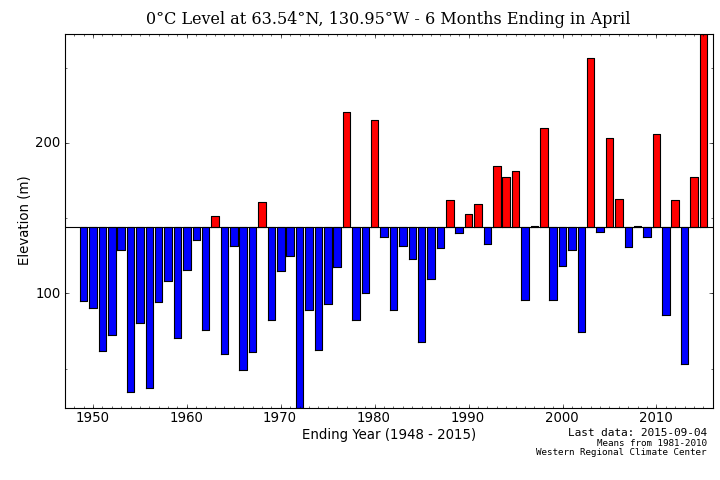
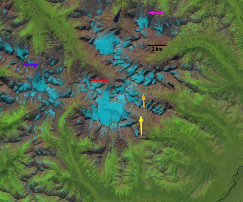
In the Selwyn Mountain Range, Yukon at the headwaters of the Hess River is the Hess Mountains and Keele Peake the highest peak in the region. A series of glacier radiate from this region. The Yukon Territory is host to numerous small alpine glaciers that have been rapidly losing area and volume.  From 1958-2007 glaciers lost 22% of their volume in the Yukon (Barrand and Sharp, 2010).  Due to the high snowlines David Atkinson, at University of Victoria notes the rate of retreat has increased since then, and is using weather stations to identify the specific conditions driving the ice loss. Semmes and Ramage (2013 ) observed in the Yukon River Basin from 1988 to 2010 a significant lengthening of melt duration t with earlier melt onset in high elevations  and significant later end of melt refreeze in theintermediate elevations ( 600 to 1600 m). Here we examine in particular a glacier draining southeast from the Hess Mountains that feeds the Hess River using Landsat imagery from 1986 to 2015.
hess map

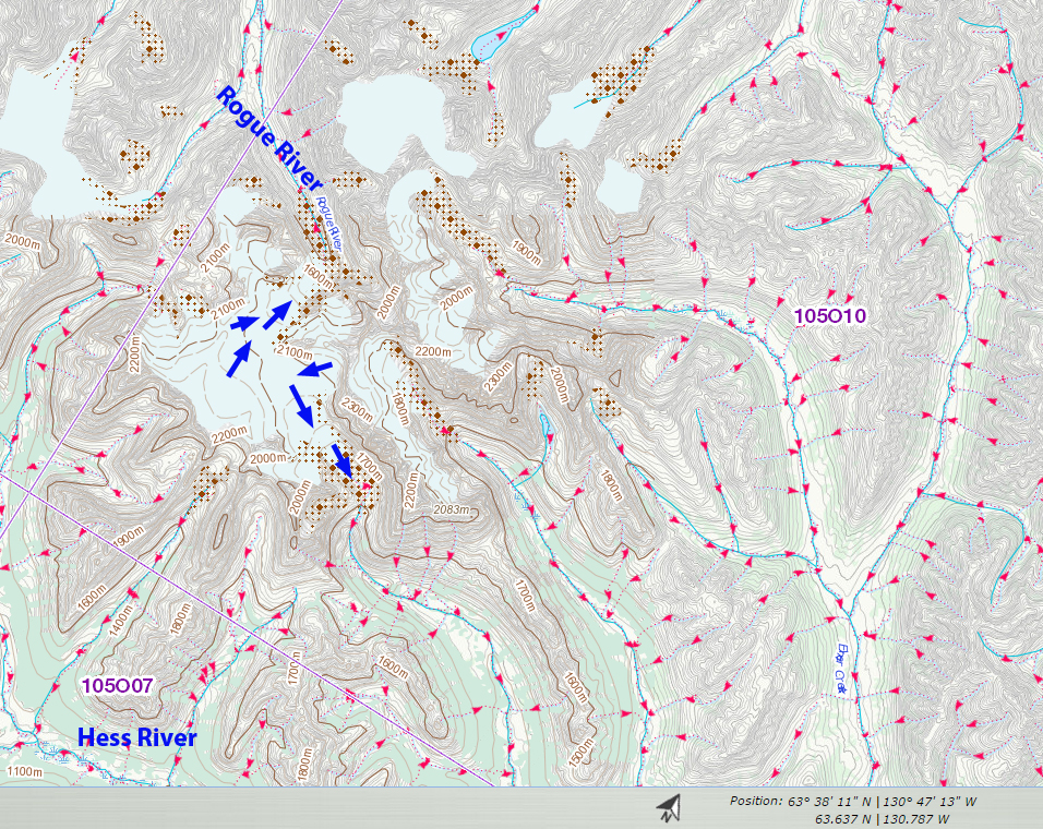
In this Canadian Toporama image the glacier of primary interest has flow indicated by the blue arrows.

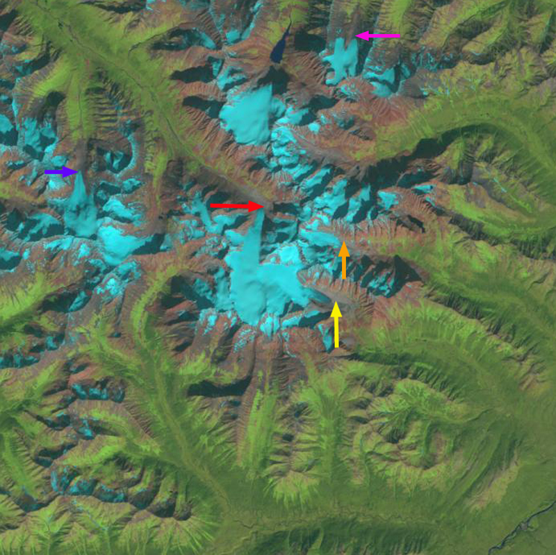
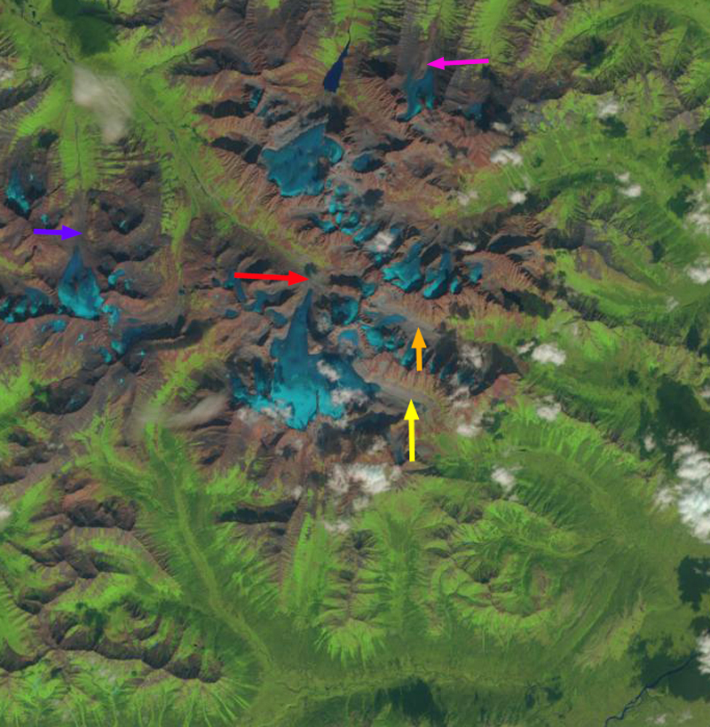
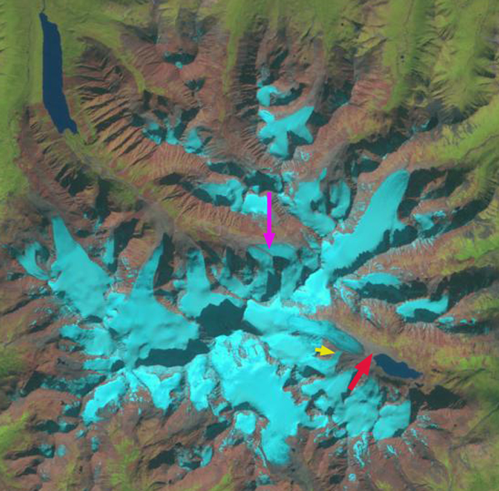
In 1986 the glacier extended to within a 100 meters of an alpine lake, with the terminus indicated by the red arrow.  The glacier was joined near the terminus by a tributary at the yellow arrow.  At the pink arrow a separate glacier terminus is formed by the merging of two glaciers.  In 1992 the main glacier tongue has retreated further from the lake.  By 2015 the tributary no longer is connected to the main glacier and terminates 600 meters above the valley.  The main glacier terminus has retreated 800 meters since 1986, and is now just over 3 km long. The terminus area at the glacier flowing north at the pink arrow, is no longer formed by the merging of two glacier termini, as two distinct termini exist.
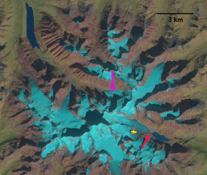
hess 1986

1986 Landsat Image

hess 1992

1992 Landsat Image

hess 2015

2015 Landsat Image


Rogue River Icefield Rapid Retreat, Selwyn Mountains, Yukon

The Selwyn Mountains, Yukon Territory are host to numerous small alpine glaciers that have been rapidly losing area and volume. David Atkinson, atmospheric scientist at University of Victoria has been examining the weather conditions leading to the extensive melting and higher snowlines. From 1958-2007 glaciers lost 22% of their volume in the Yukon (Barrand and Sharp, 2010).  Due to the high snowlines Atkinson notes the rate of retreat has increased since then.  The freezing level as determined by the North American Freezing Level Tracker illustrates this point with 2015 being the highest winter freezing level. Here we examine response of the Rogue River Icefield using Landsat imagery from 1986-2015.  The icefield is at the headwaters of the Rogue River and also drains into the Hess River.

rogue river

Canada Toporama map of the region.

selwyn

Selwyn Mountain November-April freezing levels.

In 1986 the primary icefield glacier is shown with blue arrows above indicating flow direction towards both the north and southeast terminus.  The north terminus reached the valley bottom at the red arrow and the southeast terminus extended to the yellow arrow in 1986. All arrows are in fixed locations in every image. The purple and orange arrows indicate the terminus of smaller valley glaciers in 1986.  The pink arrow indicates a valley glacier that is split into two terminus lobes by a ridge. By 1992 the only significant change is the southeast terminus of the primary glacier at the yellow arrow. In 2013 the snowline is exceptionally high at 2200 meters, with glacier elevations only reaching 2300 m.  Retreat is extensive at each terminus.  In 2015 the satellite image is from early July and the snowline has not yet risen significantly.  Terminus retreat at the yellow arrow is 900 meters, at the red arrow 400 m, at the purple arrow 600 m, at the pink arrow 400 m and at the orange arrow 500 m.  Given the length of these glaciers at 1-3 km this is a substantial loss of every glacier.  Further south in the Yukon high snowlines are also a problem for Snowshoe Peak Glacier.

rogue river 1986

1986 Landsat image

rogue river 1992

1992 Landsat image

rogue river 2013

2013 Landsat Image

rogue river 2015

2015 Landsat image


Snowshoe Peak Glacier Retreat, Yukon

There was the Yukon Gold Rush and then there are a number of surging glaciers in the Yukon. These two have drawn our attention. In Kluane National Park, besides the large surging outlet glaciers draining the St. Elias Mountains (Donjek, Lowell, Kaskawulsh etc.) there are numerous smaller alpine glaciers in ranges just east of the St. Elias. In a recent ice core study in the Eclipse Icefield it was found that the Gold Rush led to higher fire activity (Yalcin et al., 2004). This post examines several of these glaciers that have not been the focus of any detailed study, in the are of Airdrop Lake and Snowshoe Peak. Each of the glaciers is 1.5 to 2.0 kilometers long, beginning near 2100 meters the summit area of Snow Peak and terminating between 1800 and 1900 m. This is relatively small elevation change for alpine glaciers. In the 2003 Google Earth Imagery the lack of snowcover is evident. The blue line is the terminus position from the map of 1970’s and the brown line a 1998 satellite image. There are a few outrops of rock in the midst of the glacier that formerly terminated at Airdrop Lake. Comparison of a 1987 (top), 2003 (middle) and a 2010 (bottom) Landsat image indicate that the two key outcrops that were in the midst of the glacier in 1990 are at the terminus in 2010. Two others have expanded and with terminus retreat are markedly closer to the margin of the glacier in just seven years from 2003-2010. The lower section of each glacier is quite thin and uncrevassed. The lack of snowcover during many recent years indicate a mass balance loss and glacier thinning that is driving the retreat. It does not appear the glacier that flows toward Airdrop Lake can survive, with thinning high on the glacier and limited retained snowcover. There are some patches of stagnant ice near the terminus of the Airdrop Lake Glacier, this glacier has retreated 250-450 meters from the map to 2003, 20-30% of the glacier length and is still retreating quickly as the 2010 imagery indicates. The Snowshoe Peak glaciers have retreated 150 m to 300 meters which is 10-20% of the glacier length. The retreat of the small glaciers here parallels that of the larger glaciers nearby such as Melbern Glacier.