Double Glacier, Alaska Retreat at the Double & A Volcanic Ash Blanket

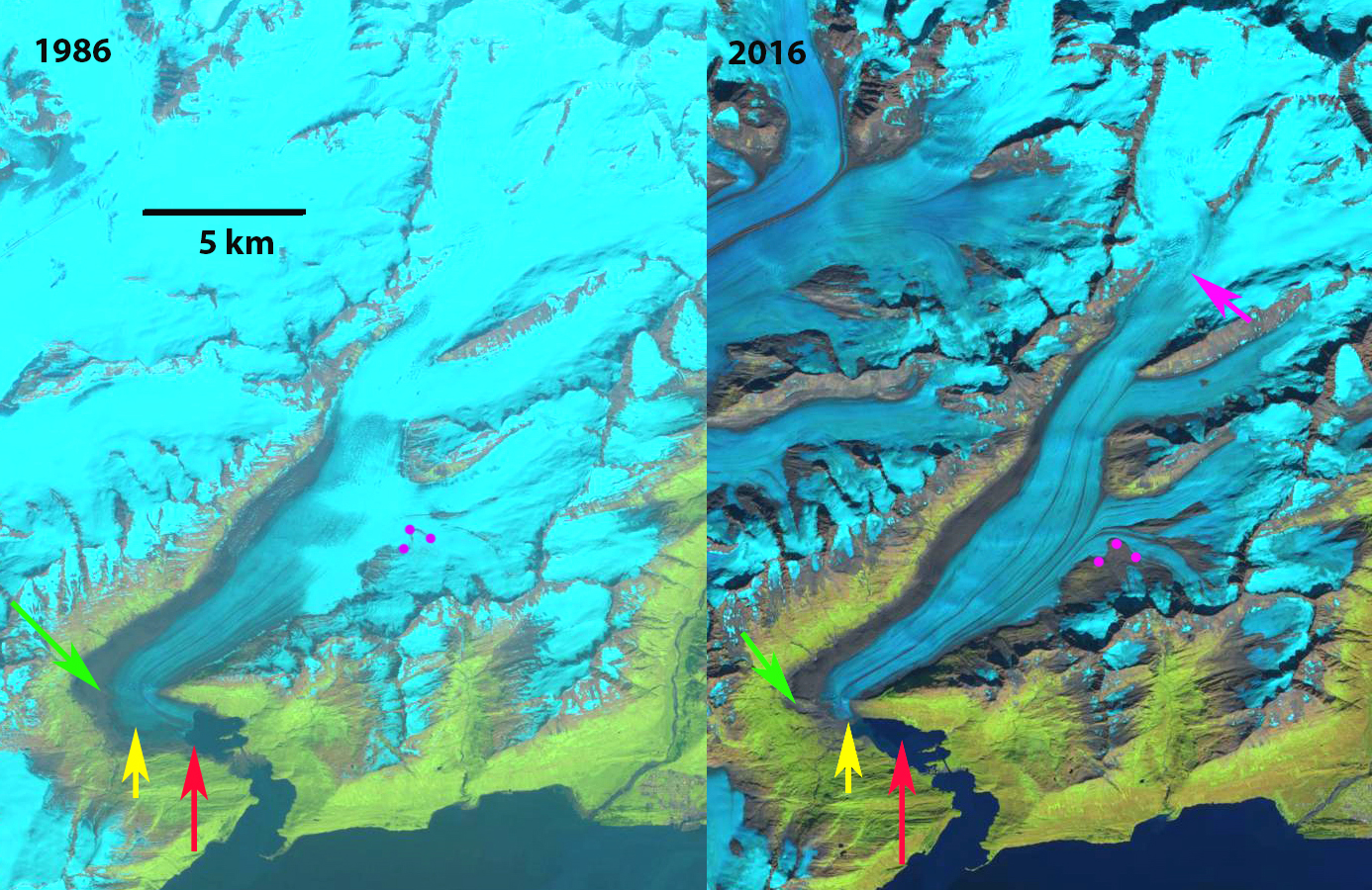
Double Glacier, Alaska in 1986 and 2017 Landsat images.  The 1986 terminus location of the northern Big River Lobe and Southern Drift River Lobe are shown with red arrows. Yellow arrows indicate the 2017 terminus locations.  Purple dots indicate the snowline.  Point A indicates a prominent and expanding nunatak that is below the snowline.

Double Glacier is the largest glacier contained within the Lake Clark National Park (LCNP) with an area of 137 km2 (Arendt et al, 2012). The glacier has a double eastern terminus with the northern or Big River Lobe terminus feeding the South Branch Big River and the southern terminus or Drift River Lobe feeding the Drift River.  From 2001-2008 Arendt et al (2012) found that Double Glacier had large elevation losses of ~2 m/year below 1400 m. From 1956-2007 Double Glacier lost 7% of its area, which was below average in the region (NPS, 2012). Here we examine Landsat imagery from1986-2017 to identify changes of the glacier including the surface impact of Mt. Redoubt volcano 2009 eruption.

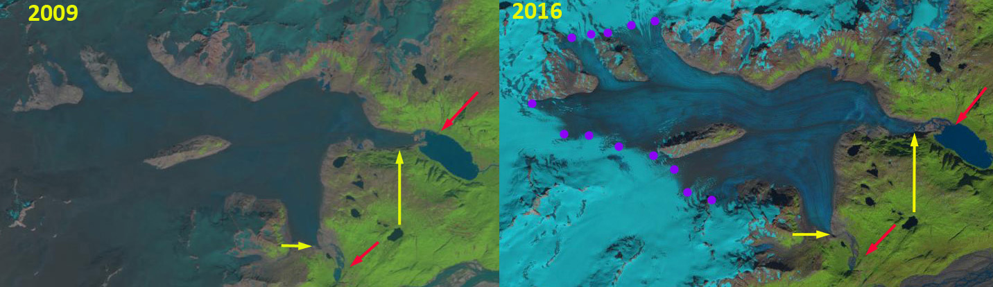
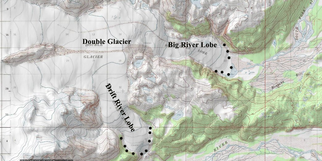
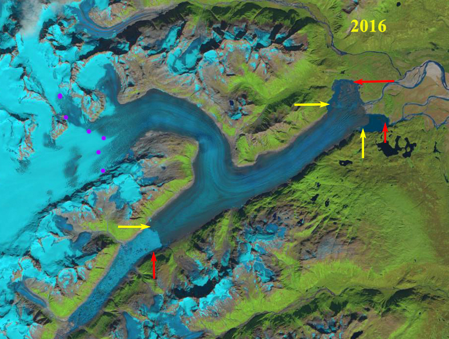
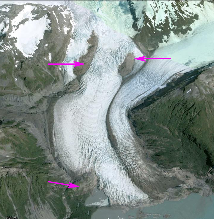
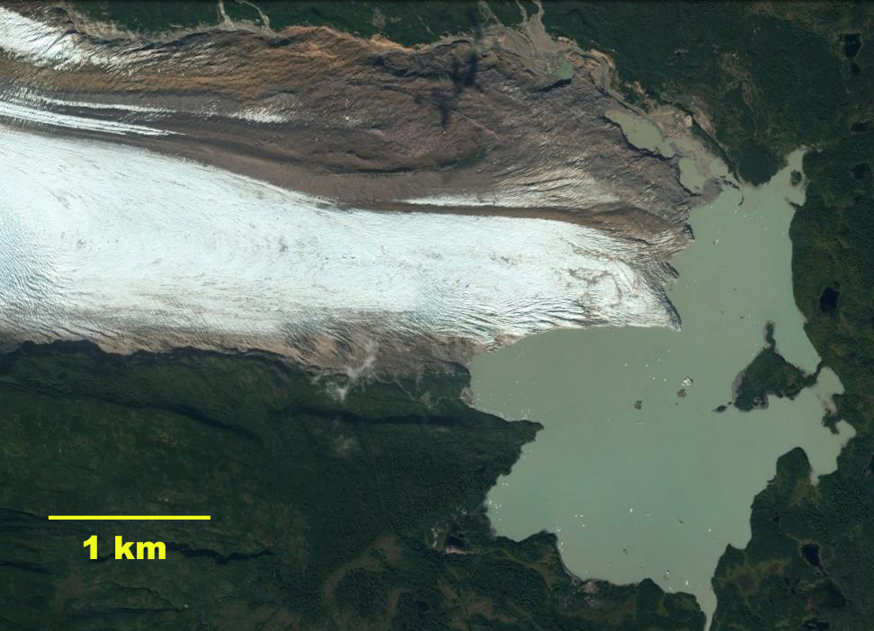
In the 1956 Kenai Topographic map the Drift River Lobe extends to  an elevation of 150 m almost to the Drift River Valley bottom.  The Big River Lobe terminates near the eastern end of the proglacial lake that is just a small fringing water body. In 1986 the Big River Lobe reached the western margin of a 2.5 km long proglacial lake (Big River Lobe Lake), red arrow.  The Drift River Lobe terminated at a ridge at 300 m, red arrow.  A prominent nunatak, Point A extends 4 km up the middle of the glacier from 850 m to 1050 m in elevation.  The snowline is at 1050 m. In 2009 the most striking visual is volcanic ash covers the entire glacier.  This is from Redoubt volcano which the  Alaskan Volcano Observatory reports on the 2009 eruption of this stratovolcano on the west side of Cook Inlet beginning in March 2009. Nineteen major ash-producing explosions generated ash clouds that reached heights between 5200 m and 18900 m. During ash fall in Anchorage, the Ted Stevens International Airport was shut down on for part of March 28  and March 29. The explosive phase ended on April 4 with a dome collapse and an ash cloud that reached 15,200 m and travelled southeast, depositing up to 2 mm of ash fall in Homer, Anchor Point, and Seldovia. The final lava dome ceased growth by July 1, 2009. In 2009 the Big River Lobe has retreated 500 m from the 1986 position.  The Drift River Lobe has had a 1600 m retreat since 1986.  This retreat was not driven by the ash that fell just months before the Landsat image was acquired. In 2016 the snowline is at 1050 m.  The ash remains evident in the ablation zone. In 2017 the snowline is again at 1050 m in late July, with six-eight weeks left in the melt season.  The Drift River Lobe terminus retreat from 1986-2017 has been 1700 m.  The Big River Lobe terminus retreat from 1986-2017 has been 1400 m.  The decreased albedo from the ash between 1986 and 2017 is evident and will lead to enhanced ablation zone melting and retreat. The Nunatak, Point A is located below the snowline each year.  Glacier thinning has led to the expansion in width and vertical relief from the glacier of this nunatak. The lowest 1 km of the glacier today is narrow and fed by a thin ice tongue. The retreat of this glacier is similar to that of Blockade GlacierHallo and Spotted Glacier in the same region, each have had substantial retreats with lake expansion.

Double Glacier, Alaska in 2009 and 2016 Landsat images.  The 2009 image indicates ash fall from Redoubt Volcano covering the glacier. The 1986 terminus location of the northern Big River Lobe and Southern Drift River Lobe are shown with red arrows. Yellow arrows indicate the 2017 terminus locations.  Purple dots indicate the snowline.  Point A indicates a prominent and expanding nunatak that is below the snowline.

Kenai Topographic map indicating glacier margins in 1956. 


Blockade Glacier, Alaska Retreat Generates Expanding Lake

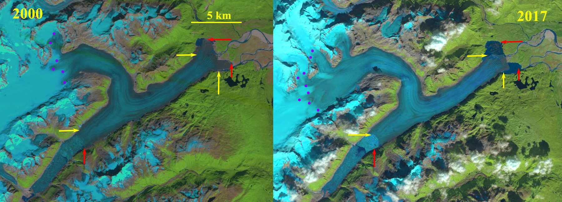
Blockade Glacier in 2000 and 2017 Landsat images.  Red arrow indicates 2000 terminus locations, yellow arrows 2017 terminus locations and purple dots the snowline. 

Blockade Glacier drains east from the Neacola Mountains in southern Alaska.  The glacier has two prominent terminus locations, the western terminus is in Blockade Lake, blocked by the glacier and the eastern terminus is in a new expanding lake at the headwaters of the MacArthur River. Arendt and Larsen (2012) assessed the glacier changes in Alaska National Parks and found in Lake Clark NP that glacier area declined by 11% from 1956 to 2008.  Hallo and Spotted Glacier in the same region have had substantial retreats with lake expansion.

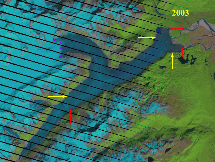
In 2000 the eastern terminus of Blockade Glacier terminates on an outwash plain with a narrow discontinuous fringe of open water. In 2000 and 2003 the western terminus in Blockade Lake is actively calving across the 1.5 km front, making the front difficult to distinguish.   The snowline is at 1000 m.  The eastern terminus has not changed since 2000 and the snowline is at 900 m.  By 2016 the western terminus has retreated 600 m and with retreat the width of the calving front has increased to 1.8 km.  The wider calving front along with what should be increasing lake depth should lead to a greater calving flux and retreat of the western terminus. The eastern terminus has two embayments filled with a glacier lobe.  The southern lobe has collapsed opening up a a 1 square kilometer lake area.  The snowline in 2016 is at 1000 m. By 2017 the eastern terminus has retreated 1200 m on the south side and 1700 m on the north side.  The northern lobe has now largely collapsed like the southern lobe leading to a lake expansion of 1.5 square kilometers.  The lake depth should be increasing and when the center pulls back from the outwash plain it is still grounded on, glacier retreat will increase.  The snowline is at 1200 m in 2017.

Blockade Glacier USGS map, indicating the lack of a lake at the eastern terminus. 

Blockade Glacier in 2003 Landsat image.  Red arrow indicates 2000 terminus locations, yellow arrows 2017 terminus locations and purple dots the snowline.

Blockade Glacier in 2016 Landsat image.  Red arrow indicates 2000 terminus locations, yellow arrows 2017 terminus locations and purple dots the snowline.

Alsek Glacier, Alaska Retreat & Glacier Separation

Alsek Glacier in a 1984 Landsat image and 2017 Sentinel image.  Red arrows indicate 1984 terminus, yellow arrows 2017 terminus location, pink arrows tributaries that joined the glacier in 1984 and purple dots the snowline.  AR=Alsek River, G=Gateway Knob and P=Prow Knob.

Alsek Glacier descends from the Fairweather Range terminating in Alsek Lake on the coastal plain. The glacier terminated at Gateway Knob (G) near the outlet of Alsek River from Alsek Lake in the early part of the 20th century (Molnia, 2005). At that time it had a joint terminus with Grand Plateau Glacier. The glacier retreated 5-6 km by 1984 along the central margin from Gateway Knob. The glacier remained connected with the Grand Plateau Glacier in 1984. In 1960 the glacier had a single terminus joining downstream of an unnamed island in Alsek Lake, that Austin Post told me reminded him of a boats prow. This “Prow Knob” (P) much like Gateway Knob a century ago stabilizes the terminus. Retreat from this knob will lead to an increase in retreat of Alsek Glacier. Here we examine the change from 1984-2017 with Landsat and Sentinel imagery.

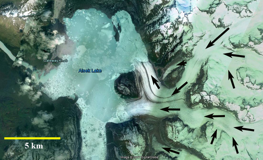
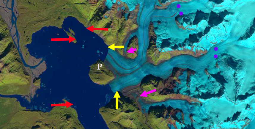
In 1984 the terminus location is denoted with red arrows it has separated into two termini on either side of “Prow Knob”. The northern terminus tongue is located on a narrow island on the north side of Alsek Lake. The southern tongue merges with the northern arm of Grand Plateau Glacier. Two tributaries at the pink arrows merge with the main glacier. In 1984 the snowline is at 900 m. By 1999 the northern tongue has retreated from the narrow island, which exposes the terminus to enhanced calving. The southern terminus has separated from the Grand Plateau Glacier. In 1999 the snowline is at 900 m. By 2013 the northern terminus has retreated almost to the northern end of “Prow Knob” and the southern terminus is directly south of “Prow Knob” in a 1.8 km wide channel. By 2016 two tributaries of Alsek Glacier are fully detached from the glacier, pink arrows. In 2017 the northern terminus tongue has retreated 3.7 km since 1984 into the 2.0 km wide channel on the northeast side of “Prow Knob”. The center of the southern terminus has retreated 3.0 km since 1984 and remains in the channel on the south side of “Prow Knob”. The length of the calving front has declined from an 8 km long calving front in 1984 to a 4 km calving front in 2017. In both 2016 and 2017 the snowline is at 1200 m, at this elevation the mass balance of the glacier will be significantly negative driving further retreat. Larsen et al (2007) indicate thinning in the lower Alsek Glacier of 3+m/year in the last half of the 20th century, indicating the glacier is a in a long term adjustment to climate change.  The retreat of this glacier is similar to that of Walker Glacier and North Alsek Glacier, and less than that of the northern arm Grand Plateau Glacier to which it was connected in 1984 or Yakutat Glacier a short distance north.   

Alsek Glacier in a 1999 Landsat image .  Red arrows indicate 1984 terminus, yellow arrows 2017 terminus location, pink arrows tributaries that joined the glacier in 1984 and purple dots the snowline.   P=Prow Knob.

Alsek Glacier in 2014 Google Earth Image,indicating flow directions. 
Alsek Glacier in a 2016 Landsat image .  Red arrows indicate 1984 terminus, yellow arrows 2017 terminus location, pink arrows tributaries that joined the glacier in 1984 and purple dots the snowline.   P=Prow Knob.


Bridge Glacier, Southeast Alaska Retreat & Lake Formation

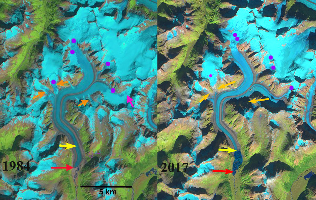
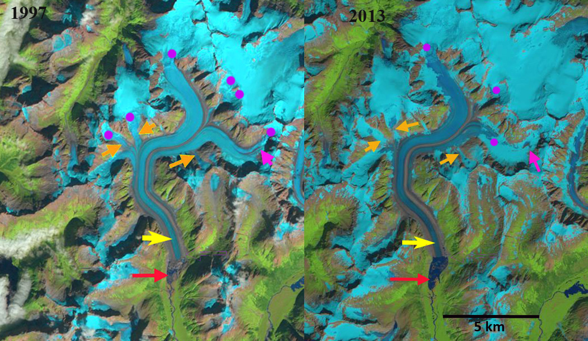
Bridge Glacier in Landsat image from 1984 and Sentinel image from 2017. The red arrow indicates the 1984 terminus where no lake exists, yellow arrow is 2017 terminus, orange arrows are selected tributaries and purple dots the snowline. 

Bridge Glacier drains the same icefield as the Wright and Speel Glacier 45 km southeast of Juneau, Alaska. Here we examine the changes in this glacier from 1984-2017 using Landsat and Sentinel imagery.

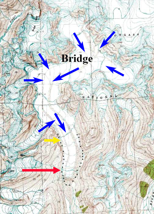
In 1984 the glacier ended on an outwash plain at the head of a branch of Speel River. The red arrow indicates the 1984 terminus for each image, the yellow arrow the 2017 terminus and the orange arrows three tributaries feeding the glacier.  The purple dots indicate the snowline at 1200 m. In 1984 all three tributary glaciers fed Bridge Glacier and the glacier has no proglacial lake at the terminus. In 1997 a lake basin is beginning to develop, though it is still largely filled by ice. The eastern tributary pink arrow, has lost all of its snowpack. The three tributaries at the orange arrows are connected to Bridge Glacier still and the snowline is at 1250 m. In 1999 the proglacial lake has formed and has length of 1 km, the lake has expanded south and north of the 1984 terminus position, and does not entirely represent glacier retreat.  In 2013 the glacier has retreated 1200 m from the 1984 position and the lake is still expanding. The orange arrows indicate that none of the three tributaries are still connected to the main glacier. The glacier in a sense is losing its income flow from these subsidiaries. The eastern tributary has retained some snowcover with six weeks left in the melt season in 2013, but this is mostly gone a month later, the snowline is at 1100 m. nbsp; Total retreat from 1984 to 2017 is 1900 m. In 2017 the snowline is at 1300 m, and the separation of the tributaries is by more than 500 m in each case. The snowline has been high by the end of each summer from 2014-2017 indicating retreat will continue. The retreat of this glacier is the same story as seen at nearby PattersonGilkey and Norris Glacier.
.

Bridge Glacier in Landsat images from 1997 and 2013. The red arrow indicates the 1984 terminus , yellow arrow is 2017 terminus, orange arrows are selected tributaries and purple dots the snowline. 

Bridge Glacier in USGS map when it ended on the outwash plain in 1948.


Field Glacier, Alaska Retreat, Leads to Glacier Separation

Field Glacier in Landsat images from 1984, 2013 and 2017.  The red arrow indicates the 1984 terminus, the yellow arrows the 2013 terminus and the yellow dots the 2017 terminus.  The purple arrows indicate developing lateral margin lakes in 2013 and purple dots the transient snowline.

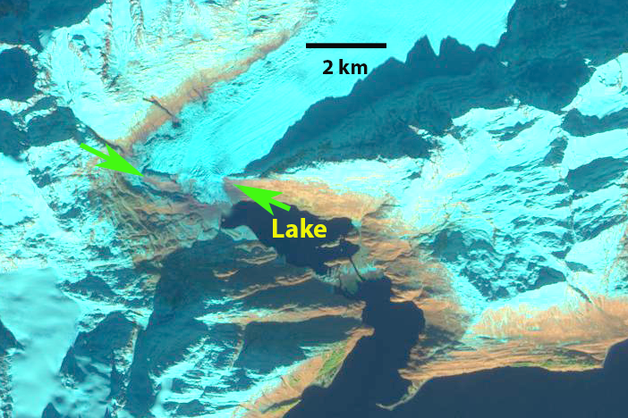
The Field Glacier flows from the northwest side of the Juneau Icefield, and is named for Alaskan glaciologist and American Geographical Society leader William O. Field. Bill also helped initiate the Juneau Icefield Research Program, which Maynard Miller then ably managed for more than 50 years. The JIRP program is still thriving today. In 1981, as a part of JIRP, I had my first experience on this glacier. It was early August and there was new snowfall everyday that week. Jabe Blumenthal, Dan Byrne and myself undertook a ski journey to examine the geology on several of the exposed ridges and peaks, note the burgundy line and X’s on image below. This was truly a remote area. The glacier begins from the high ice region above 1800 meters, there are several icefalls near the snowline at 1350 meters, and then it descends the valley ending at 100 meters. The runoff descends the Lace River into Berners Bay.This post focuses on the significant changes occurring at the front of the Field Glacier. The development of a proglacial lake at the terminus is accelerating and spreading into the main southern tributary of the glacier.  In 2013 it was observed that the lake was going to quickly expand and develop a second arm in that valley, as the two main tributaries separate.

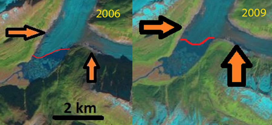
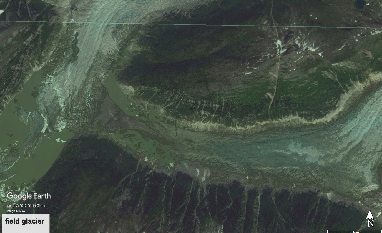
The USGS map from 1948 imagery and the 1984 imagery indicate little change in the terminus position, with only a small lake at the terminus in 1984 with most of the margin resting on the outwash plain.  The Field Glacier by 2006 had developed a proglacial lake at the terminus that averaged 1.6 km in length, with the east side being longer. There are several small incipient lakes forming at the margin of the glacier above the main lake, each lake indicated by black and orange arrow. In 2009 the lake had expanded to 2.0 km long and was beginning to incorporate the incipient lake on the west side of the main glacier tongue. There was also a lake on the north side of this tributary. This lake was noted as being poised to soon fill the valley of the south tributary and fully merge with the main, as yet unnamed lake at the terminus, maybe this should be Field Lake.   In 2013 Google Earth imagery indicates the fragile nature of the terminus tongue that is about to further disintegrate. From 1984 to 2017 Field Glacier has experienced a retreat of 5300 m of the southern branch and 4050 m of the northern branch. This glacier is experiencing retreat and lake expansion like several other glaciers on the Juneau Icefield, Gilkey GlacierEagle Glacier, and Antler Glacier.

.

Development of proglacial lakes from 2006 to 2009.

Terminus noted for 1984 and 2011 and the snowline in 2011.  JIRP camp locations noted by X’s.

2013 Google Earth image of the terminus. Many small icebergs already separating.


Ellsworth Glacier Retreat & Lake Expansion, Alaska

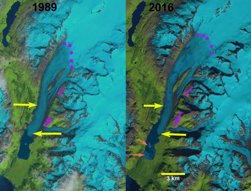
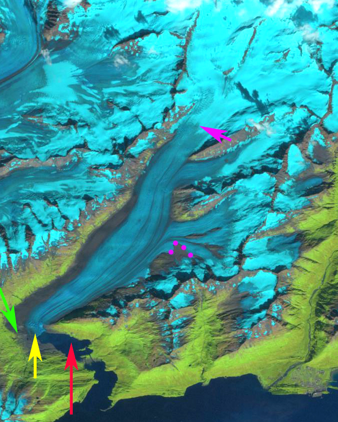
Ellsworth Glacier in 1989 and 2016 Landsat images.  Upper yellow arrow marks the west terminus in 2016 and the lower yellow the 2016 east margin.  Purple dots mark the snowline and purple arrows tributaries from the east that are thinning and disconnecting.  Orange arrow marks icebergs in the lake. 

Ellsworth Glacier is a valley glacier draining south from Sargent Icefield on the Kenai Peninsula in Alaska. Along with the Excelsior Glacier it has been the longest glacier of the icefield.  The glacier retreated into an expanding proglacial lake in the early 20th century (USGS-Molnia, 2008). The terminus in 2000 was reported to be  3.5 to 4.5 km from the 1908 position (USGS-Molnia, 2008).  Here we examine Landsat images to document changes from 1989 to 2016. 

In 1989 the snowline was at 925 m, purple dots, a tributary from the east joined just above the terminus, lower yellow arrow.  The terminus had a small embayment on the west side.  In 2001 the snowline was at 875 m, with little evident change in the terminus position.  By 2015 the tributary from the east has detached from the main glacier, the snowline is at 1000 m.  The lake has expanded considerably along the western margin and the tongue of the glacier has narrowed in the lower 2 km.  In 2016 the snowline is at 975 m, the lake has now extended 3 km along the western edge.  This rapid lake expansion indicates that the lower 3 km of the glacier occupies a basin that will become a lake and that the tongue is partially afloat and given the narrowing thinning tongue is poised for collapse, see below.  The number of icebergs in 2016 indicates that significant ice calved during that year. The retreat of the eastern margin has been 500 m, with a 3.4 km retreat on the west side.  The main tongue in the lower two kilometers is 800 m wide versus 1200 m wide in 1989.  It is also worth noting the greening of the elongated nuntak in the middle of the glacier several kilometers above terminus.  Along with the rapid 3.5 km retreat of the adjacent Excelsior Glacier, leaves the longest glacier from the icefield up for grabs. 

Ellsworth Glacier in 2001 and 2015 Landsat images.  Upper yellow arrow marks the west terminus in 2016 and the lower yellow the 2016 east margin.  Purple dots mark the snowline and purple arrows mark tributaries from the east that are thinning and disconnecting. 

Ellsworth Glacier in2016 Landsat image.  Upper yellow arrow marks the west terminus in 2016 and the lower yellow the 2016 east margin.  Purple arrows mark tributaries from the east that are thinning and disconnecting.  Orange arrow marks icebergs in the lake. 

Pedersen Glacier, Alaska Rapid Retreat 1994-2015

Pedersen Glacier Kenia Peninsula, Alaska retreat from Landsat images in 1994 and 2016. The red arrow indicates 1994 terminus, yellow arrow is 2016 terminus, orange arrow indicates northern tributary and purple dots indicates snowline. 

Pedersen Glacier is an outlet glacier of the Harding Icefield in Kenai Fjords National Park near Seward, Alaska. The glacier drops quickly from the plateau of the icefield through a pair of icefalls terminating in a lake at 25 meters above sea level.  The Harding Icefield glaciers that drain east are in the Kenai Fjords National Park, which has a monitoring program.  Giffen et al (2014) observed that from 1950-2005 all 27 glaciers in the Kenai Icefield region examined retreated.  Giffen et al (2014) observed that Pedersen Glacier retreated slow but steady from 1951-1986 at 706 m (20 m/a) and 434 m (23 m/year) from 1986-2005. Here we compare a 1994, 2013, 2015 and 2016 Landsat imagery illustrating a rapid increase in retreat rate from the previous periods.

In 1994 the terminus proglacial lake at the terminus is small and much of the terminus is on land.  The snowline in 1994 is at 550 m.  The tributary entering from the north, orange arrow, is 400 m wide as it reaches Pedersen Glacier.  In 2005 the Google Earth image below indicates extensive terminus crevassing, indicating substantial terminus velocity, and that the retreat is driven by calving.  In 2005 the lake is now 1.1 km long on its center axis.  By 2015 the glacier has retreated 2600 m since 1994, a rate of 125 m/year, much faster than before.  The snowline is average 800 m.  The northern tributary is now barely reaching the main glacier and has a width of 150 m. Note there was a medial moraine separating the tributary from the main glacier in 1994 and now this is merely a lateral moraine. This tributary is not particularly impacted by calving losses and indicates a rising snowline is also a source of mass loss for the glacier. A comparison of the 2013, 2015 and 2016 terminus indicates the recession has remained rapid.  The glacier is approaching the base of an icefall that would represent the inland limit of the lake and the end of rapid retreat.  The snowline in 2013 averages 850 m and is at 800 m on Sept. 30 2016. The glacier follows the pattern of nearby Bear GlacierYakutat GlacierHarris Glacier and the inital phase of retreat on Brady Glacier.

Pedersen Glacier Kenia Peninsula, Alaska retreat from Landsat images in 2013 and 2015. The red arrow indicates 1994 terminus, yellow arrow is 2015 terminus, green arrow indicates 2016 terminus and purple dots indicates snowline. 

Pedersen Glacier in 2005, note crevassing at the terminus, pink arrow. The northern tributary is indicated by orange arrow and green arrow indicates 2016 terminus position. 

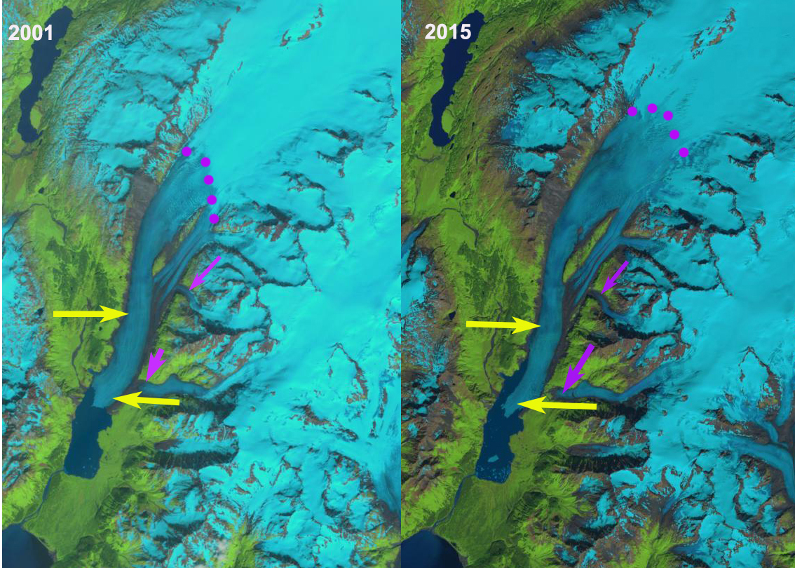
Fasset Glacier, Alaska Retreats from Tanis Lake

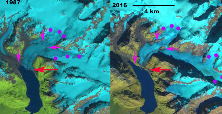
Fasset Glacier in 1987 and 2016 Landsat images.  Red arrow indicates glacier front in 1987, pink arrows indicates areas where glacier retreat has exposed rock/bare ground and purple dots indicate snowline.

Fasset Glacier drains west from The Brabazon Range near Yakutat and had terminated in Tanis Lake for the entire 20th century.  (Truessel et al 2013) and Truessel et al (2015) note the rapid retreat and thinning of nearby Yakutat Glacier. Here we examine Landsat imagery that illustrates the retreat from 1987 to 2016. 

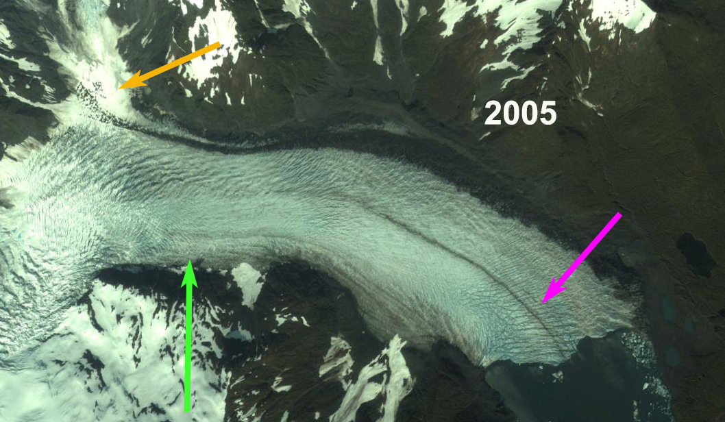
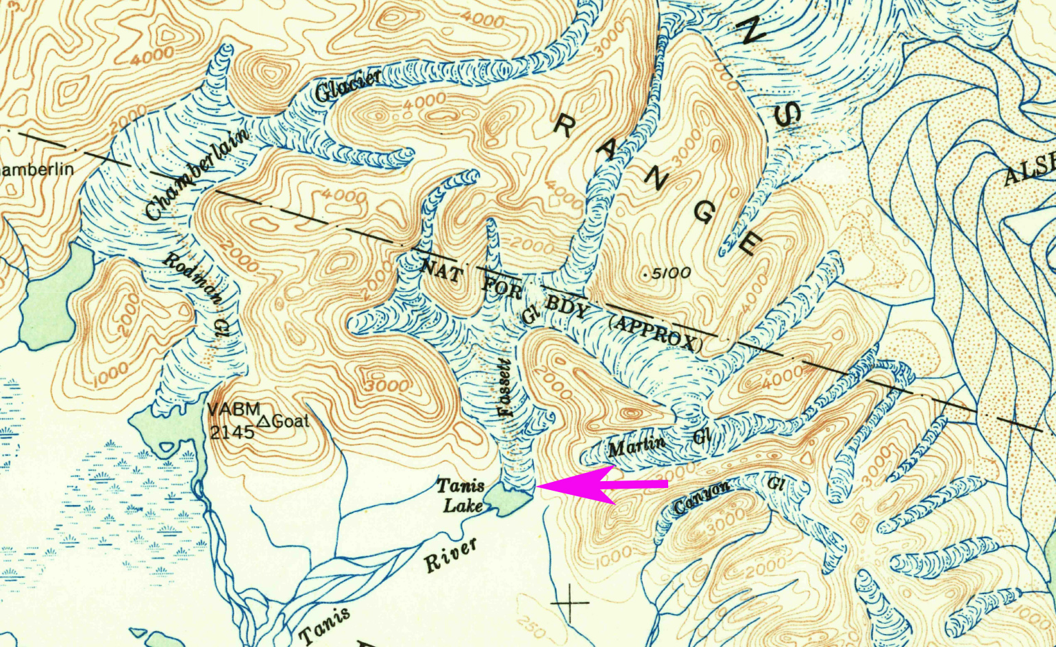
The glacier extended most the way to the southern end of the Tanis Lake in the 1951 Yakutat map.  In 1987 the glacier terminated on the northeast shore of Tanis Lake. The calving front in the lake was 800 m wide.  The snowline was at 600 m.  In mid-June of 2014 the snowline was already at 600 m, by the end of the melt season it was at 900 m. In 2016 the terminus of the glacier no longer reaches Tanis Lake. The eastern side of the terminus is stagnant and ends 200 m from the shore of the lake.  The western edge terminates in a new lake that is forming.  The average retreat has been 250 m for the glacier from 1987-2016. The larger changes are upglacier of the terminus where large areas of bedrock have been exposed due to retreat, and several segments of the glacier that used to be joined have separated. The snowline is at 850 m in 2016. There are three large areas of bedrock denoted in the 2014 Google Earth image below.  The two at 500 m well above the terminus appeared as medial moraines in 1987 and are now bedrock ridges 600 m and 1100 m long. There is a group of ogives extending below these two locations indicating the annual flow rate is 100 m/year in this reach of the glacier.  The new lake is also evident in the Google Earth image. 

Walker Glacier, Yakutat Glacier and East Novatak Glacier are nearby glaciers that have experienced greater recent retreat than Fasset Glacier.  Fasset Glacier is poised to continue a moderate rate of retreat. 

USGS Yakutat map from 1951

2014 Google Earth image, pink arrows indicate three areas of thinning. 

2014 Google Earth image.

2014 June Landsat image indicating snowline. 

Yakutat Glacier Terminus Collapse, 10 km retreat 1987-2016

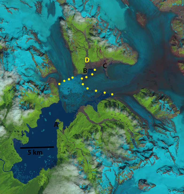
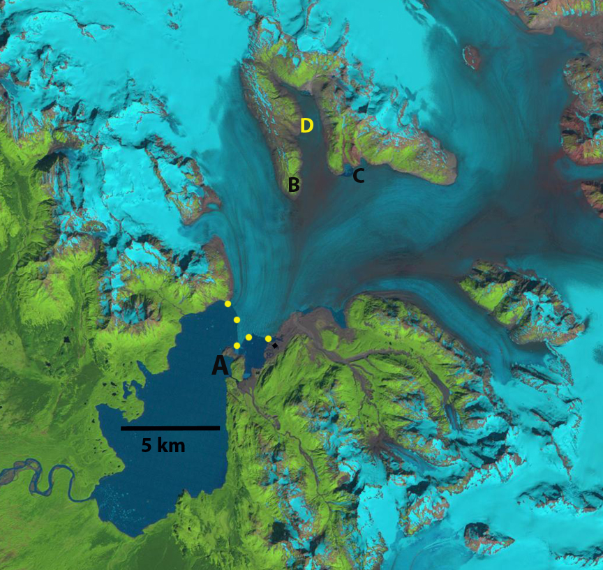
Landsat images from 1987 and 2016 with terminus indicated by yellow dots. Point A indicates the 1987 terminus location and Point E the 2016 terminus location. 

The Yakutat Glacier during the 1894-1895 Alaskan Boundary Survey ended near a terminal moraine on a flat coastal outwash plain. By 1906 the glacier had retreated from the moraine and a new lake was forming. Harlequin Lake. Surveys of the terminus of the glacier indicated a retreat of 1 kilometer in that decade. From 1906-1948 the glacier retreated an additional 5 km. From 1948-1958 the glacier retreated 3.6 km. The retreat is evident in comparing the Yakutat B-3 quadrangle, from 1958 photography, and Landsat imagery from 1987, 2010, 2013 and 2016. Points A-E are the same in each image and the yellow dots are the terminus. In 1987 the terminus was just retreating from a peninsula marked A, the valley at D was filled with ice, there was no break in the surface at C and B was well inland of the terminus. By 2010 the glacier had retreated from A, the valley at D was deglaciated, a small strip of bedrock-sediment was exposed at C from what had been beneath the glacier, and B was still well inland of the terminus. By 2013 the northern arm of the glacier had retreated 6.4 km from the peninsula at A toward the peninsula at B. The central arm of the glacier toward C had retreated 7.5 km and the retreat on the southern edge of the glacier was 6.5 km. The glacier had retreated on average more than 6.6 km in 27 years, a rate of 240 m/year.  From 2013 to 2016 the glacier had retreated from Point B to Point C on the northern side and to Point E on the southern side this is a distance of 10.2 km in thirty years 340 m/year. 

Recently the glacier has been the focus of a study by the University of Alaska, Faribanks they have set up a time lapse camera to record frontal changes. The goal is to understand the controls on calving into Harlequin Lake of this glacier. More amazing than the retreat has been the observed thinning of the glacier. The glacier has thinned by more 200 m on average according to the preliminary thickness change maps from the UAF project (Truessel et al 2013) and updated by Truessel et al (2015). The Yakutat Glacier does not have a high accumulation zone and the recent increase in the snowline elevation and thinning of the glacier have led to a substantial shrinking of the accumulation zone and thinning of the glacier in the accumulation (Truessel et al 2013). This glacier does not have a persistent significant accumulation zone and cannot survive (Pelto, 2010), Truessel et al (2015). modelling suggests the glacier will disappear between 2070 and 2110 depending on the warming scenario.  For a calving glacier to be in equilibrium it needs to have at least 60 % of its area snowcovered at the end of the summer. The glacier is in the midst of a large ongoing retreat. The retreat rate and calving mechanism is similar to that of Grand Plateau Glacier, Bear Lake Glacier and Gilkey Glacier. However, unlike these Yakutat Glacier lacks an accumulation zone, a better analog is East Novatak Glacier, which also has a lower elevation accumulation zone.


Yakutat terminus map


2010 Landsat image with terminus indicated by yellow dots.


2013 Landsat image with terminus indicated by yellow dots.


Hallo Glacier Retreat, Katmai Alaska

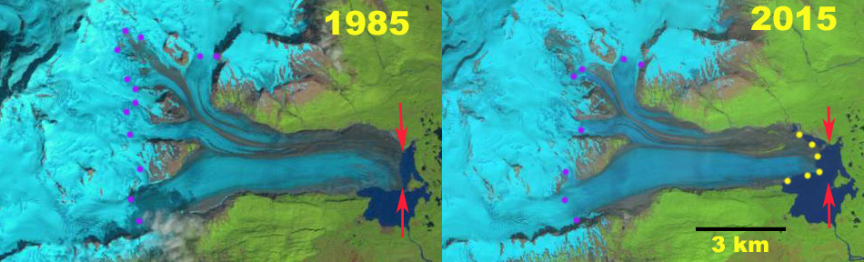
Landsat images of Hallo Glacier in 1985 and 2015 indicating the 1985 terminus position red arrows and yellow dots indicate 2015/2016 terminus location.  Purple dots show the snowline

Hallo Glacier is one of the larger glaciers in Katmai National Park draining east from Mount Steller and ending in an expanding proglacial lake east of Hallo Bay.  Hallo Bay is well known as a good location for brown bear watching (NPS).  Arendt and Larsen (2012) assess the glacier changes in Alaska National Parks they provide a map of the change in glacier extent from 1956-2009, Figure 7.  This indicates a significant retreat but it is not quantified. They further note a 15% decrease in areal extent of Katmai Region glaciers from 1956-2009.  Giffen et al (2015) indicate the glacier retreated 900 m from 1951-1987 and then advanced 150 by 2000. Here we utilize Landsat imagery to examine retreat from 1985 to July 2016 to examine the glaciers response.

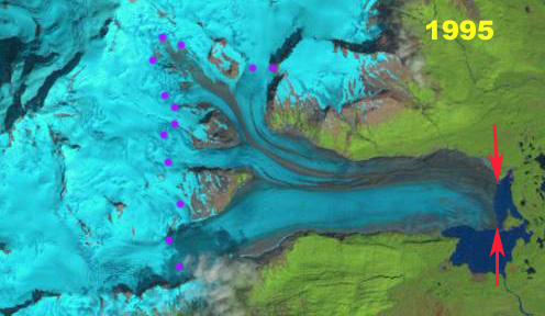
In 1985 the glacier terminated just off the western shore of a small island in the lake.  The terminus front in the lake measured 3000 m in length.  The snowline averaged 1050 m across the glacier. By 1995 little retreat had occurred, the snowline was averaged 1050 m. In 2000 the glacier terminus had changed little from 1985.  The average snowline was at 1100 m. In 2015 the terminus had retreated 600 m from the island and 800 m along the northern shore of the lake.  The snowline is at 2000 m.  In 2016 the snowline is averages 1150 m , the highest observed. The terminus front in the lake remains 3000 m long.  The rate of retreat increased after 2000, and the glacier is poised for additional retreat. A 2013 Google Earth image illustrates that the lower 3.5 km of the glacier has a low slope and limited crevassing, except for minor crevassing along southern calving front.  This indicates the lake is likely to expand at least to this point.  Further that the glacier is poised for continued significant retreat and lake expansion.  The retreat is less than, but similar to that of nearby  FourPeaked  and  Spotted Glacier.


1995 Landsat image of Hallo Glacier indicating the 1985 terminus position red arrows.  Purple dots show the snowline

2000 Landsat image of Hallo Glacier indicating the 1985 terminus position red arrows and yellow dots indicate 2015/2016 terminus location.  Purple dots show the snowline

2016 Landsat image of Hallo Glacier indicating the 1985 terminus position red arrows.  Purple dots show the snowline.

2013 Google Earth image of Hallo Glacier, note low uncrevassed terminus tongue in lower 3.5 km.


Shoup Glacier, Alaska Retreat, Thinning, Velocity Decline

Shoup Glacier comparison in 1986 and 2016 Landsat images.  The glacier retreated 1900 m in this interval.  Red arrow is 1986 terminus, yellow arrow the 2016 terminus, green arrow rock rib emerging from beneath glacier, purple dots a landslide deposit, and purple arrow the snowline.

Shoup Glacier is between the Columbia Glacier and Valdez draining from the Chugach Mountains in southern Alaska.  The glacier was a tidewater terminating glacier until 1953 (McNabb et al, 2014).  From 1985 to 2011 McNabb et al (2014) noted a 1.7 km retreat.  The retreat was enhanced by significant lacustrine calving in an expanding tidal lagoon.  Here we examine Landsat and Sentinel images from 1986-2016 to identify recent and potential future changes.

In 1986 the glacier extends to the red arrow in the midst of a tidal lagoo. The glacier is 2.5 km wide at the sharp bend in the glacier 2.5 to 3 km from the terminus, green arrow.  There is significant crevassing at this bend indicating an increase in slope.  There is an landslide/avalanche deposit near the junction with a tributary, purple dots.  By 2002 the glacier has retreated 1.5 km since 1986, the minor ice cliff at the terminus indicates the glacier ends in shallow water near the end of the tidal lagoon.  The glacier is now 2 km wide at the sharp bend.  The landslide deposit, purple dots,  has shifted little since 1986. The snowline is at 1200 m in 2002.  By 2016 the glacier has retreated an additional 400 m since 2002, 1900 m since 1986.  The glacier no longer terminates in the lagoon.  A bedrock rib at the sharp bend has been exposed and the glacier is only 500 m wide now and this bend is just 500 m from the terminus, green arrow.  A closeup of this rib in a 2016 Sentinel image indicates why the crevassing had occurred, it is also clear this is an extension of the ridge that runs east from the glacier.  This is a band of erosion resistant rock.  This suggests that a basin exists above the this bedrock rib/ridge and a new lake will form.  The glacier slope from the green arrow for the next 2 km upglacier is quite low 1/40, again indicative of a basin beneath the lower glacier.  There is an increase in crevassing 2 km above the current terminus,  suggesting another increase in surface slope and the probable limit of the basin.  In 2016 the snowline is at 1250 m.  The landslide deposit remains little changed since 2002, indicating a low velocity in this region.  Burgess et al (2013) indicates the velocity of the Shoup Glacier near the terminus is in the range of 100 m annually.  The tributary is clearly significantly less. The low velocity, thinning and retreat indicates the glacier is continuing to lose volume via surface melting, despite no longer calving as Larsen et al (2015) have indicated is the prime mechanism for ice loss.  The retreat of this glacier is similar to that of nearby Valdez Glacier.

Shoup Glacier comparison in 2002 Landsat image.  Red arrow is 1986 terminus, yellow arrow the 2016 terminus, green arrow rock rib emerging from beneath glacier, purple dots a landslide deposit, and purple arrow the snowline.

Shoup Glacier terminus in 2016 Sentinel 2 image.  Green arrows indicate rock rib. 

Desolation Valley, Alaska, Conversion from Glacier to Lake


desolation-compare

Retreat of Desolation-Fairweather Glacier from 2010-2016 in Landsat images.  The red arrow indicates 2010 terminus positions, yellow arrow the 2016 terminus. Pink arrow a delta exposed by lake level lowering. D=Desolation Glacier.

Desolation Glacier flows west from the Fairweather Range into Desolation Valley where in 1986 it joined with the Fairweather Glacier flowing from the north and the Lituya Glacier flowing from the south to fill the valley with glacier ice.  This is no longer the case, the valley once known for its long relatively flat area of largely debris covered ice, is mostly a lake now.  The valley has developed along the Fairweather Fault. Molnia (2007) noted that the tidewater termini of Lituya Glacier advanced ∼ 1 km since 1920 and continued to advance up to 2000 as it built an outwash plain reducing calving. Larsen et al (2015) noted thinning rates of 3 m per year for the Desolation Valley from Desolation Glacier north to Fairweather Glacier in the last decade (1994-2013).  Alifu et al (2016) identified that Desolation Glacier and Fairweather Glacier have lost 2.6% and 2.2% of their glacier area, respectively from 2000-2012. Only minor surface area changes were seen in Lituya Glacier during this period. They also noted that the mean snow line altitude of Fairweather, Lituya and Desolation increased by 120–290 m. Since 2012 extensive ice loss of the Desolation-Fairweather complex has occurred.  This is similar to the large rise in the transient snowline/equilibrium line noted by Pelto et al (2013) on nearby Brady Glacier.

In 1986 The Desolation Valley was filled with glacier ice from Fairweather Glacier to Liutya Bay.  By 2010 the southern half of the valley from Lituya Glacier to the outlet of Desolation Glacier into the valley had opened up and the terminus of Desolation Glacier and Lituya Glacier were at the red arrows, this represented a 5.3 km section of glacier lost. In 2013 the northern half of the valley filled by the Desloation-Fairweather Glacier was breaking up but still ice filled.  The Google Earth image from 2014 illustrates how broken up.  By 2016 the collapse was total and the new terminus is at the yellow arrow a 5.5 km retreat since 2010, this is a loss of 6.5 square kilometers of ice. The lake level also dropped which led to exposure of a lacustrine delta that had been submerged in 2013 and 2014, pink arrow. The lake has expanded in area, but lost in mean depth.  Will this continue to be a lake with continued retreat or become a braided river valley as the Fairweather Glacier continues to thin and retreat?  Desolation Glacier is no longer calving and its retreat rate should slow.  The terminus of the Fairweather Glacier should continue to retreat via calving in a fashion similar to glaciers around the world terminating in extensive lakes. Just to the north the North Fork Grand Plateau Glacier also experienced a large recent retreat with Landsat imagery in 2013 and 2014 indicating extensive calving from 2013 to 2015 and a retreat of 3.0 km, 1.5 km/year.  Fingers Glacier  is another nearby glacier that also is experiencing widespread retreat.  More images of the region are in a field blog on the region.

desolatiion-1986-2013

Retreat of Desolation-Fairweather Glacier from 1986 and 2013 in Landsat images.  The red arrow indicates 2010 terminus positions, yellow arrow the 2016 terminus. Pink arrow a delta exposed by lake level lowering. D=Desolation Glacier.

desolation-breakup

Google Earth image from 2014 of the disintegrating debris covered glacier.