Central Andean Glaciers Laid Bare for Last Half of Summer 2022

Volcan Overo in Sentinel image continues to fragment with no retained snowcover this summer, and bedrock expansion at Point A.

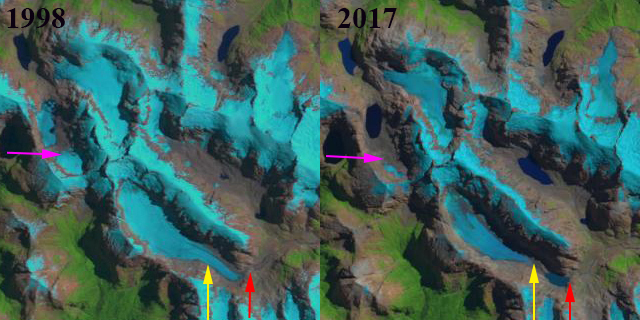
For an alpine glacier to survive it must remain mostly snowcovered throughout the year, even at the end of the summer. This is one reason for the majesty of glaciated mountains, they shine brightly even in summer.  This year in the Central Andes of Argentina and Chile I have chronicled the near total loss of snowpack in January due to early summer warmth, leading to dirty/dark glaciers.  This is a similar story to what we saw in the Pacific Northwest last summer. Here is an update at the end of the summer using Sentinel imagery to highlight that these glaciers have remained largely bare for two months. The darker surfaces of the glacier melt faster leading to more rapid area and volume loss.  This includes fragmentation and rapid expansion of bedrock areas amidst the glacier. Earlier observations indicate this is a regional issue this summer with snowpack lost from Bajo del Plomo Glacier Cortaderal GlacierPalomo Glacier, Volcan Overo Glaciers, Volcan San Jose Glaciers , Cobre Glacier and Olivares Beta and Gamma Glaciers across the Central Andes of Chile and Argentina

Cortaderal Glacier in Sentinel image with no retained snowcover this summer, and bedrock expansion at Point A.

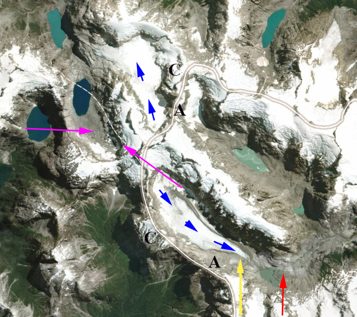
Volcan San Jose Glaciers in Sentinel image continues to fragment with ~5% retained snowcover this summer, and bedrock expansion at Point A.

Las Vacas Glaciers in Sentinel image continues to fragment with no retained snowcover this summer, and bedrock expansion at Point A.

Olivares Beta and Gamma Glacier  in Sentinel image with no retained snowcover this summer, retreating away from proglacial lakes and bedrock expansion at Point A.

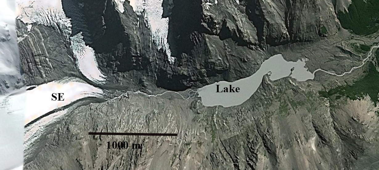
Bajo del Plomo Glacier in Sentinel image with no retained snowcover this summer, and rapid bedrock expansion at Point A.

Palomo Glacier in Sentinel image with no retained snowcover this summer, and bedrock expansion at Point A.

Volcan Peteroa Glacier in Sentinel image continues to fragment with ~2% retained snowcover this summer, and bedrock expansion at Point A.

Cobre Glacier, Argentina Rapid Retreat and Area Loss in 2022

Cobre Glacier, Argentina in false color Sentinel 2 images from Jnauary 13, 2022 and March 16, 2022. Note the expansion of bedrock area amidst the glacier at Point A, glacier fragmenting at Point B and Point C.

Cobre Glacier drains east from Cerro Orejas a 3949 m peak on the Chile-Argentina border and discharges into the Rio Tordillo. The summer of 2022 has been a difficult season for glaciers in the Central Andes of Chile and Argentina as has been observed with early snowpack loss on Bajo del Plomo Glacier,  Cortaderal GlacierPalomo Glacier, Volcan Overo Glacier and Olivares Beta and Gamma Glaciers.  Here we can utilize Sentinel 2 satellite imagery to observe the retreat from 2016-2022 and the area losses apparent during the summer of 2022.

In March 2016 Cobre Glacier terminated on the northern shore of a proglacial lake at ~3000m.  By March 2022 the glacier had retreated 700 m from the lake in just six years. During this period thinning of the glacier had narrowed the connections at Point A-C, while a new lake basin is evolving at Point D.  Early summer warmth led to a rapid loss of snowpack on Cobre Glacier in 2022. By January 13, 2022 ~5% of the glacier had small pockets of snowcover above 3800 m. Bare ice glacier surfaces melt more rapidly than snow covered surfaces. After over two months of bare ice ablation the small areas of emergent bedrock on January 13, near Point A have enlarged and merged with the margin of the glacier by March 16. At Point B a small ice cap is separating from the main glacier. At Point C a narrow tongue of ice that had connected the main glacier to a small terminus segment has been severed.  At Point D margin retreat is leading to expansion of the proglacial lake along the margin of the glacier.  In just two summer months the impact of a single warm summer is evident on Cobre Glacier.  It is also evident that with no persistent accumulation zone this glacier cannot survive current climate( Pelto, 2010). Dussaillant et al (2019) identified slower mass loss  -0.28 m/year in this region from 2000-2018, than further south in the Patagonia Andes or north in the Tropical Andes. In 2022 the Central Andes are experiencing a rapid loss.

Cobre Glacier in Sentinel 2 images from March 2016 and March 2022. Illustrating retreat from 2016 terminus (red arrow) to 2022 terminus (yellow arrow). Fragmentation of the glacier underway at Point A-C is evident. A new evolving lake is at Point D.

Turbio Glacier Retreat, Argentina Generates New Lake

Turbio Glacier retreat from 1986 to 2018 in Landsat images.  Red arrow is 1986 terminus location, yellow arrow 2018 terminus location and pink arrow glacier across the border in Chile.

Turbio Glacier is at the headwaters of the Turbio River, Argentina and flows into Lago Puelo.  The glacier descends east from  Chile/Argentina border at 1500 m descending into a low slope valley at 1300-1000 m.  From 1986-2018 this glacier like many others nearby has retreated substantially leading to development of a new lake.  Wilson et al (2018) noted a substantial growth in the number of lakes in the central and Patagonian Andes due to the ongoing rapid retreat.  Masiokas et al (2008) reported that significant warming and decreasing precipitation over the 1912–2002 interval in the region. Harrison et al (2018) observed the number of glacier lake outburst floods have declined despite the increase in lakes.

In 1986 the glacier terminated at the southeast end of a buttress at the junction with another valley, red arrow. The glacier was 4.3 km long and was connected to a headwall segment that extends to 1500 m. There is no evidence of a lake at the terminus of Turbio Glacier.  Across the divide in Chile the glacier with a pink arrow has a length of 3 km.  In 1998 the retreat from 1986 has been modest and no lake has formed at Turbio.  Across the border in Chile the glacier has divided into two sections.  By 2017 Turbio Glacier has retreated exposing a new lake.  The glacier is essentially devoid of retained snowpack illustrating the lack of  a significant accumulation zone that can sustain it.  Across the border in Chile the glacier has nearly disappeared with the lower section revealing a new lake and little retained snowpack indicating it cannot survive.  By 2018 Turbio Glacier has retreated 1.3 km, which is over 30% of its total length in 32 years. The glacier is separated from the headwall glacier, which can still shed avalanches onto the lower glacier. It is possible that with additional retreat another lake will be revealed in this valley.  The substantial retreat here is comparable with that of nearby Argentina glaciers such as Pico Alto Glacier and Lago Cholila .  The retreat is greater than on Tic Toc Glacier to the southwest in Chile.

Turbio Glacier retreat from 1998 to 2017 in Landsat images.  Red arrow is 1986 terminus location, yellow arrow 2018 terminus location and pink arrow glacier across the border in Chile.

Turbio Glacier in a Digital Globe image from 2013.  Red arrow is 1986 terminus location, yellow arrow 2018 terminus location, blue arrows show glacier flow and pink arrow glacier across the border in Chile.  The border is also indicated.

Cerro Tronador Glacier, Argentina Retreat and Lake Formation

Cerro Tronador glaciers in Landsat images from 1985, 1998 and 2018.  A=Alerce, CO=Castana Overo, VN=Ventisquero Negro.  Red arrows mark the 1985 glacier terminus locations, yellow arrows the 2018 terminus location of VN, pink arrow the location of the 2009 dam breach outwash plain deposit, and purple arrow location of a bedrock outcrop. 

Cerro Tronador with a summit elevation of 3428 m straddles the Chile/Argentina border east of Lago Todos los Santos.  The peak is heavily glaciated including three glaciers that flow into the Alerce River basin of Argentina, Ventisquero Negro (VN), Castana Overo (OV) and Alerce (A).  Paul et al (2014) observed a 25% decrease in glacier area and the formation of over 100 new proglacial lakes in Northern Patagonia. Worni et al (2014) report on a moraine dam breach below Ventisquero Negro in 2009 and model this event. Here we examine Landsat imagery from 1985 -2018 to identify changes.

In 1985 there is no lake at the terminus of Ventisquero Negro with the debris covered terminus extending across the entirre basin.  The pink arrow indicates the vegetated valley below the moraine.  Alerce Glacier extends over a topographic step at 1600 m and extends to a proglacial lake at 1350 m. Castana Overo Glacier terminus broadly extends over the topographic step at 1600 m.  By 1998 Ventisquero Negro has developed a small fringing proglacial lake.  Alerce Glacier has lost its lowest valley tongue that extended to the proglacial lake.  The width of the Castana Overo Glacier terminus has been reduced.

By 2012 below the moraine dam breach has occurred depositing a significant outwash plain that is evident at the pink arrow just downstream of Ventisquero Negro.  A substantial proglacial lake has also formed that is 1.2 km long, Lago Manso.  Alerce Glacier has retreated to the top of the 1600 m step. A new bedrock outcrop, purple arrow has appeared on the ridge between Alerce and Castana Overo Glacier at 2100 m.  In 2016 the snowline extends to the new bedrock outcrop. By 2018 Ventisquero Negro has retreated 1450 m since 1985, with the proglacial lake still growing.  Alerce Glacier has retreated 800 m since 1985 and Castana Overo Glacier has retreated 400 m.  All three glaciers have significant crevassing indicating substantial retained accumulation being transported down slope. The debris covered tongue of Ventisquero Negro will continue to disintegrate and the Lago Manso will continue to expand.

Cerro Tronador glaciers in 2012 Google Earth image.  A=Alerce, CO=Castana Overo, VN=Ventisquero Negro.  Red arrows mark the 1985 glacier terminus locations, , pink arrow the location of the 2009 dam breach outwash plain deposit, and purple arrow location of a bedrock outcrop. 

Cerro Tronador glaciers in 2016 Digital Globe image.  A=Alerce, CO=Castana Overo, VN=Ventisquero Negro.  Red arrows mark the 1985 glacier terminus locations, , pink arrow the location of the 2009 dam breach outwash plain deposit, and purple arrow location of a bedrock outcrop. 


Sierra de Sangra Glacier Retreat, Argentina

mayer compare

Comparison of four outlet glaciers of Sierra de Sangra in Argentina in a 1985 and 2015 Landsat image.  Read arrow is the 1986 terminus location when all terminated in a lake.  By 2015 only one terminates in a lake, yellow arrows. 

The Sierra de Sangra Range is located along the Chile-Argentina boundary with the east draining glaciers flowing into the Rio Mayer and then into Lake O’Higgins at Villa O’Higgins. Here we examine four glaciers that in 1986 all ended in lakes and by 2015 only one still terminates in the lake. Davies and Glasser (2012) noted the fastest retreat rate of this icefield during the 1870-2011 period has been from 2001-2011. NASA’s Earth Observatory posted an article on this blog post with better resolution images.

mayer ge

Sierra de Sangra is just east of Villa O’Higgins with the crest of the range on the Chile Argentina border. The four glaciers examined here are indicated by S, SE, E and N. 

The South Outlet Galcier (S) has retreated 700 m from 1986 to 2015 and terminated in a lake in 1986.  By 2015 it terminates on a steep slope well above the lake.  The Southeast Outlet Glacier (SE) terminates in a lake in 1986.  By 2015 it has retreated 1200 m to a junction with a tributary from the north.  The East Outlet Glacier is the largest glacier and has retreated just 300 m from 1986 to 2015. There is a sharp elevation rise 200 m behind the terminus, which likely marks the end of the lake basin.  This is marked by a crevasse zone.  The North Outlet Glacier (N) ended in a lake in 1986.  By 2015 it has retreated 700 m and ends on a bedrock slope well above the former lake level. All of the glaciers have an accumulation zone in each satellite image examined.  This indicates they can survive present climate. The glacier retreat is not as large as Cortaderal Glacier and Glaciar Del Humo.

mayer terminus

Google Earth images from 2013 of the terminus of three outlet glaciers above and one below.  The red arrow indicates terminus location. Three of the four no longer terminate in a lake. 

mayer southeast