Hall Peninsula Ice Cap, Baffin Island Retains No Snowcover in 2023 Fosters Fragmentation

Hall Peninsula Ice Cap east of Popham Bay is snow free on 8-14-2023. Comparison of Landsat images from 2014 and 2023 arrows indicate four locations where the ice cap is fragmenting and at each Point D is an emerging/expanding bedrock area amidst the ice cap.

Hall Peninsula is host to many glaciers and ice caps, almost all unnamed. Here we examine the largest ice cap on the Peninsula using Landsat and Sentinel images. This ice cap is shrinking like Grinnell Ice Cap and Terra Nivea Ice Cap due to limited retained snowcover most years.

The center of the ice cap is just over 1000 m in elevation. By early August in 2023 the ice cap had lost all snowcover. The emergence and expansion of a dozen bedrock areas amidst the ice cap indicates the ice cap is thinning across most of its extent. At Arrow C and E the ice cap has fragmented. At Arrow A and B the fragmentation is nearly complete. Given the lack of any retained snowcover in several recent years, this ice cap will not survive current climate conditions.

Hall Peninsula Ice Cap on 8-6-2023 in Sentinel images. Arrows indicate locations of fragmentation. Point D marks expanding bedrock areas amidst the ice cap.

Soler Glacier Retreat and Lake Expansion

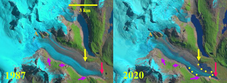
Soler Glacier in 1987 and 2020 Landsat images.  Red arrow indicates 1987 terminus location, yellow arrow indicates 2020 terminus location on north side of glacier.  Yellow dots indicate margin of lake and purple arrows indicate specific locations where glacier thinning is evident.

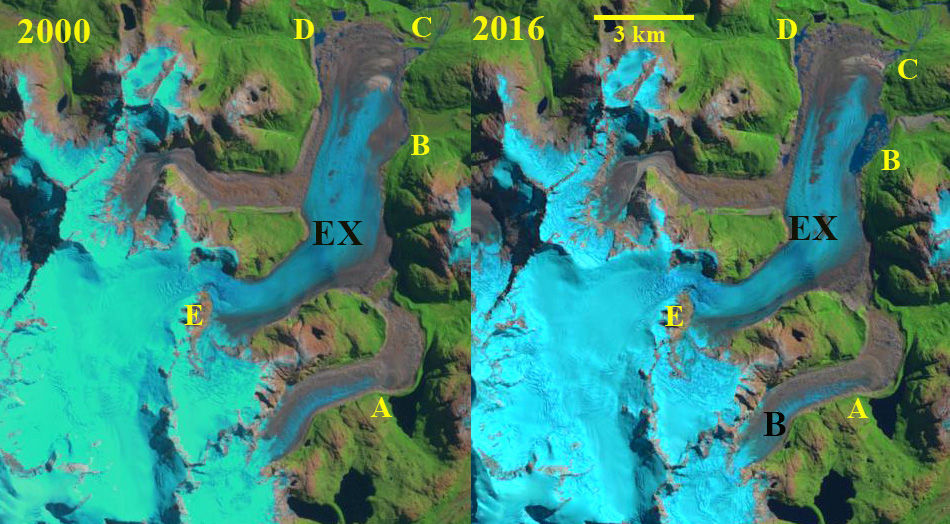
Soler Glacier is an outlet glacier on the east side of the Northern Patagonia Icefield (NPI). The terminus response of this glacier has been slower and more limited than on most NPI glaciers.  Aniya and Fujita (1986)  reported a total retreat of 200-350 m from 1944 to 1984.  Glasser et al (2016) note the recent 100 m rise in snowline elevations for the NPI, which along with landslide transport explains the large increase in debris cover since 1987 on NPI from 168 km2 to 306 km2 .  Loriaux and Casassa (2013) examined the expansion of lakes on the Northern Patagonia Ice Cap reporting that from 1945 to 2011 lake area expanded 65%, 66 km2. For Soler Glacier lake formation did not occur until the last decade and debris cover has changed little as well. Willis et al, (2012) identified thinning of ~2 m/year in the ablation zone from 1987-2011. This thinning is now leading to the development of a significant proglacial lake that is examined using Landsat images from 1987-2020.

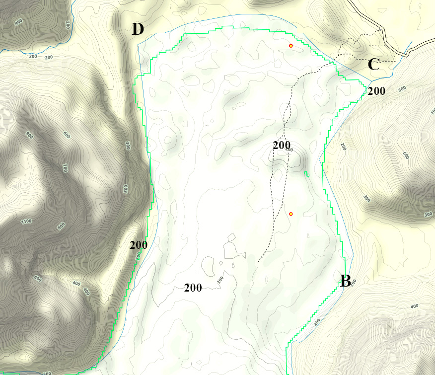
In 1987 the glacier is still up against the Little Ice Age moraine, though it had thinned considerably resulting in retreat down the slope of this vast moraine. By 2000 a small lake had developed both on the north and south side of the main terminus with a total area of ~0.3 km2, red dots. In 2016 and 2019 this lake had expanded, with the northern arm mostly filled with ice, orange dots.  In October 2020 the lake has an area of ~1 km2 and is mostly open water. The extensive thinning of the terminus tongue continues to drive both retreat and lake expansion.  The thining is evident at Point A where bedrock knobs have emerged from the ice near the snowline.  The three purple arrows on the south side of the glacier indicate thinning as these bedrock features are increasingly distant from the glacier. The terminus has retreated 500 m in the glacier center, 2100 m on the north side and 1300 m on the south side from 1987-2020.  The terminus tongue in its lowest 1.5 km continue to thin and will collapse in the lake in the near future. The end of summer snowline has averaged 1450 m in recent years leading to continued mass loss without calving in the lake (Glasser et al 2016).

Lake development here lags that of other glacier around the NPI such as Exploradores, Nef, Steffen and San Quintin.

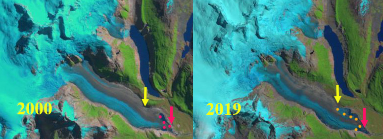
Soler Glacier in 2000 and 2019 Landsat images.  Red arrow indicates 1987 terminus location, yellow arrow indicates 2020 terminus location on north side of glacier.  Red dots  and orange dots indicate margin of lake.

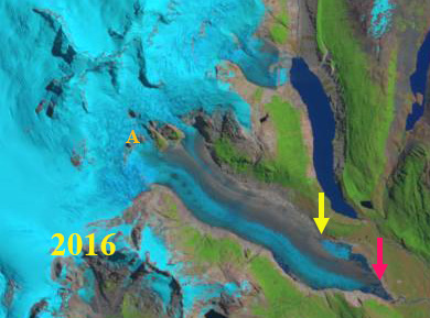
Soler Glacier in 2016 Landsat image.  Red arrow indicates 1987 terminus location, yellow arrow indicates 2020 terminus location on north side of glacier.  

Exploradores Glacier Lake Development, Chile

Exploradores Glacier  (EX) in 1987 Landsat and 2020 Sentinel image.  Points A-E are consistent locations discussed.  B=Bayo Glacier.

Exploradores Glacier is an outlet glacier at the northeast corner fo the Northern Patagonia Icefield (NPI).  Glasser et al (2016) note the recent 100 m rise in snowline elevations for the NPI, which along with landslide transport explains the large increase in debris cover since 1987 on NPI from 168 km2 to 306 km2  On  Exploradores  Glacier debris cover expanded by 5.5 km2 from 1987-2015.   Loriaux and Casassa (2013) examined the expansion of lakes on the Northern Patagonia Ice Cap. From 1945 to 2011 lake area expanded 65%, 66 km2Davies and Glasser (2012) noted the fastest retreat during the 1870-2011 period was from 1975-1986 for Exploradores Glacier. Here we examine the response of the glacier to climate change from 1987 to 2020.

In 1987 Exploradores Glacier has a 12 km2 terminus lobe with a couple of small proglacial pond with a total area under 0.2 km2 near Point D.  The snowline is at 1400 m near Point E.  A small lake is impounded by a lateral moraine of Bayo Glacier at Point A.   In 2000 there is now a single small pond near Point D and a small proglacial pond 0.1 km2 near Point C.  The snowline is at  1400 m near Point E. In 2016 small fringing proglacial ponds exist near Point C and D.  A substantial proglacial lake has developed at Point B with an area of ~1 km2 on the east margin of the glacier.  The impounded lake at Point A has not changed. In 2020 the proglacial ponds have expanded at Point C and D.  At Point B the proglacial lake has expanded to ~1.4 km2.  The snowline is above Point E at 1500 m. At Point A the impounded lake has drained somewhat and is now at a lower lake level.  The lake breached the lateral moraine, which had been increasing in relief from the thinning Bayo Glacier.  The snowline on January 1, in the middle of the melt season is already above Point E at 1500 m. The debris cover has extended 5 km up the middle of the glacier from the terminus.

The terminus lobe of the Exploradores Glacier is now collapsing, this is a process that has already occurred at Steffen Glacier, San Quintin Glacier and Colonia Glacier.  The terminus lobe is relatively stagnant as indicated by the minimal surface slope.  The retreat has been slow compared to adjacent Fiero Glacier. The result will be a new substantial proglacial lake.

Exploradores Glacier  (EX) in 2000 and 2016 Landsat images.  Points A-E are consistent locations discussed.  B=Bayo Glacier.

GLIMS view of the terminus indicating the 200 m contour and Point B-D in same location as on images.