Saleina Glacier, Switzerland Terminus Separation

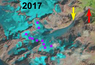
Saleina Glacier comparison in 1985 and 2015 Landsat images.  The red arrow is the 1985 terminus, the yellow arrow the 2015 terminus and the purple dots the transient snow line in these August images. 

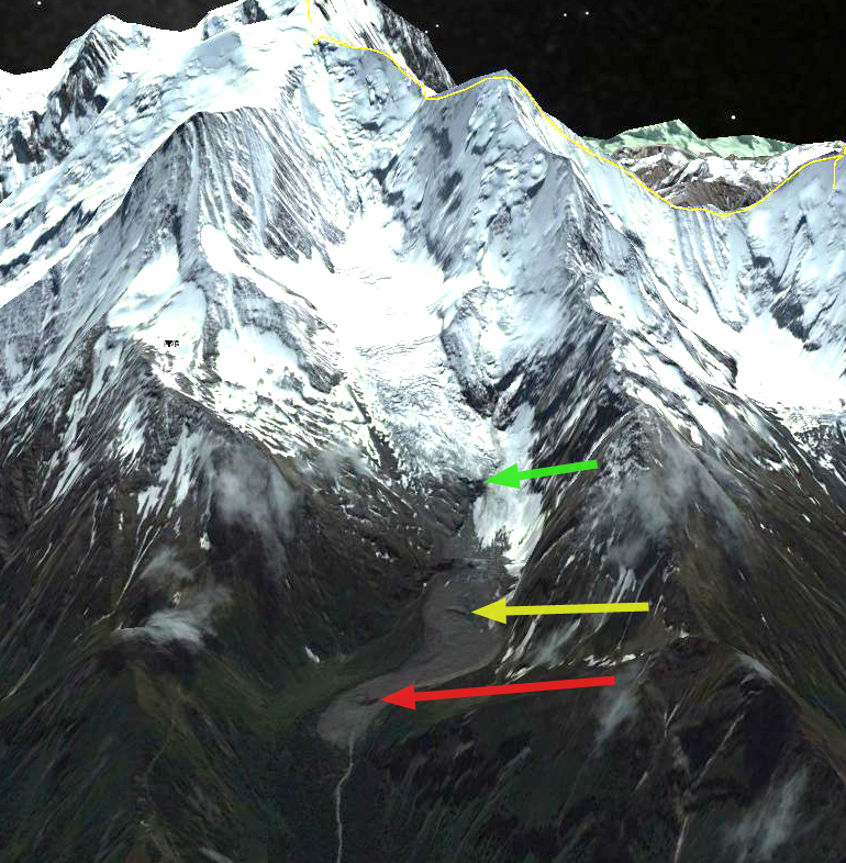
Saleina Glacier is south of Trient Glacier descending a steep eastward oriented valley from Aiguille d’Argentiere on the northern end of the Mount Blanc Range.  The Swiss Monitoring Network has maintained annual observations of the glacier front since 1878.  After a sustained retreat during the first half of the 20th century, the glacier advanced 215 m from 1964-1988.  From 1990 to 2015 the glacier retreated 640 m. 

Here we use Landsat imagery from 1985-2017 and Google Earth images to identify ongoing changes. In 1985 the glacier extended down valley to an elevation of 1850 m, just before the valley turns east.  After 2000 the lower 800 m of the glacier became debris covered, but up to at least 2009 remained crevassed indicating activity.  By 2015 this section of the glacier no longer has crevassing or glacier ice exposed at the surface and has essentially collapsed and is no longer part of the main glacier.  This is illustrated in a comparison of Google Earth images from 2011 and 2015.  Points A,B and C represent the same bedrock locations adjacent to the glacier.  The green arrows indicate a medial moraine on active ice in 2009 and what has become an ice cored moraine ridge without adjacent active ice in 2015.  In 2009 the blue arrows indicate areas of crevassing indicating active ice.  In 2015 the purple arrows indicate buried ice cored moraine as indicated by meltwater wetting the sediments.  The total retreat of the active front from 1985 to 2015 is 1250 m, with the active front at 2300 m.  The retreat has been driven by a rise in the end of melt season snowline. This amount of retreat is similar to that of adjacent Glacier du Tour

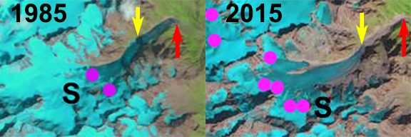
In 1985 the snow line in mid-August was at 2900 m, in 2015 in late August the snowline was at 3075 m and in late August of 2017 the snowline is at 3150 m.  The summer of 2003 is when the highest snowlines were reported across the western Alps  (Rabatel et al 2013). That summer of 2003 in mid-August the snowline on Saleina Glacier was at 3050 m in an August snowline comparison of Mont Blanc glaciers. This years snowline will likely end the year as high or higher than 2003, the extensive negative mass balance will drive further retreat.

The 2016 inventory of Swiss glaciers noted several with significant retreats due to separation of stagnant ice areas and active ice.  Saleina Glacier warrants being in this category.


Saleina Glacier in 2017 Landsat image.  The red arrow is the 1985 terminus, the yellow arrow the 2015 terminus and the purple dots the transient snow line on 8/26/2017.


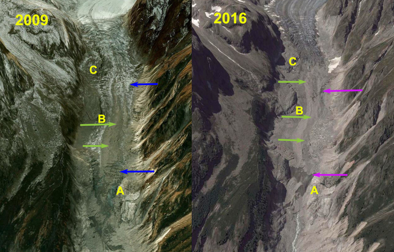
Points A,B and C represent the same bedrock locations adjacent to the glacier in the 2009 and 2015 Google Earth images.  The green arrows indicate a medial moraine on active ice in 2009 and an ice cored moraine ridge without adjacent active ice in 2015.  In 2009 the blue arrows indicate areas of crevassing.  In 2015 the purple arrows indicate buried ice cored moraine as indicated by meltwater wetting the sediments.


Yellow arrows mark the end of the active ice in 2015 on Saleina Glacier. 


Bionnassay Glacier Terminus Tongue Detaches, Mont Blanc, France

Bionnassay Glacier drains west from Dôme du Goûter and Aiguille de Bionnassay of the Mont Blanc Massif in France. The glacier has a heavily debris covered terminus and has experienced less retreat from 1980-2010 then other Mont Blance glaciers. Bionnassay retreated 200 m (Moreau et al , 2012), while Mer de Glace retreated 500 m in the interval 1998 to 2008. Gardent et al (2014) observed a 25% decline in the area of glaciers in the French Alps from 1970 to 2009, with the rate increasing significantly recently.  Bionnassay is now in rapid retreat as the stagnant terminus tongue is detached from the active glacier tongue.

bionnassay overview

Bionnassay Glacier.  Red arrow indicates terminus of stagnant region.  Yellow arrow indicates bedrock emerging that is separating stagnant terminus tongue.  Green arrow indicates lower limit of active glacier. 

In 1985 the glacier terminus is at the yellow arrow. The debris covered ice is crevassed and covers the entire region at the red and green arrow. Points B and C are ice covered and Point A has a small exposure of bedrock. In 1999 retreat from the yellow arrow is evident the glacier still covering the region at the red and green arrow. In 2001 Google Earth image the terminus is evident at the red arrow, the region at the green and yellow area are covered by glacier ice. In 2011 the terminus has retreated 180 m since 2001, bedrock has emerged at the green arrow, beginning to separate the stagnant debris covered terminus tongue. At the yellow arrow the crevassing has diminished greatly. In 2015 the terminus has retreated to the pink arrow. Bedrock has been exposed from below the glacier terminus tongue at the yellow arrow. The active glacier terminus is now at the green arrow. At Point B and C glacier thinning has led to marginal retreat and exposure of bedrock where there was glacier ice. At Point A the expanse of exposed bedrock has greatly expanded.  The retreat of the main glacier terminus is around 200 m.  However, the retreat to the newly emergent bedrock separating the glacier is 750 m.  The active terminus is now 1700 m from the 1985 terminus position at the green arrow.  In the next few years this will become a well defined terminus, as the lower stagnant zone melt away.

Bionnassay Glacier is just south of Taconnaz Glacier, which is also retreating.
bionnassay 1985
1985 Landsat image
bionnassay 1999
1999 Landsat image
bionnassay glacier ge 2001
2001 Google Earth Image
bionnassay glacier ge 2011
2011 Google Earth Image
bionnassay 2015
2015 Landsat image

500 m

Taconnaz Glacier Retreat, Mont Blanc, France

The Taconnaz Glacier flows from 4300 m to 2000 m down the west side of Mont Blanc, from the Dôme du Goûter toward the Chamonix Valley. This glacier is best known for the large avalanches that are generated by the break off of large serac ice blocks from a wide ice cliff at 3300 m during the winter, blue arrows (Le Meur and Vincent, 2006). The ice blocks have been devastating to inhabited areas of the Chamonix valley as recently as 1999. A comparison of 2004 and 2009 imagery in Google Earth indicates that the main terminus (A) has retreated 200 meters in five years. The orange line is the 2004 margin and 2009 is the red line. Taconnaz is two glaciers south of Mer de Glace, which retreated 500 m from 1994-2008, and several glaciers south of Glacier d’Argentiere, which retreated 400m from 2000-2010. There has also been a large retreat in the vicinity of Point B which is where a secondary terminus used to be connected to the main valley glacier. This retreat indicates that above the terminus there is a reduction in the volume of ice heading down valley. This suggest retreat will continue.
The avalanche hazard has prompted construction of avalanche defenses that are well documented in photographs, such as the one below. This site on Mont Blanc glaciers also has nice images of the terminus glacier from 2010 indicating a much more robust terminus than Mer de Glace, based on the crevassing and glacier thickness. The avalanche protection worked in 2006 slowing an April avalanche.