Grasshopper Glacier, Wyoming Disintegration Underway

Grasshopper Glacier, Connie Glacier, J Glacier and Sourdough Glacier in 1966 map (black outline of glaciers) and in 2022 false color Sentinel image (green dots for glacier outline). The area of Grasshopper Glacier declined from 3.28 km² to 0.81 km². Closeup of area in 2021 and 2022 illustrates the many glacier fragments.

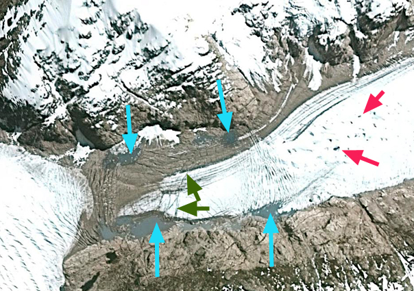
Grasshopper Glacier in the Wind River Range of Wyoming has a southern terminus calving into a lake, and a northern terminus. The southern terminus is calving and retreating expanding the unnamed lake it terminates in and retreated 350 m from 1966-2006 (Pelto, 2010).  The northern terminus retreated 730 m from 1966-2006 the most extensive retreat in the Wind River Range. (Pelto, 2010). The main accumulation area on the west side of the glacier has become segmented by large bare rock areas as noted by comparing the 1966 map and 2006 image. The area declined from 3.28 km² to 2.34 km², a 27% decline (DeVisser and Fountain, 2015).  Thompson et al (2011) noted a 38% loss in area of the 44 Wind River Range glaciers from 1966-2006. Maloof et al (2014) noted an even larger drop in volume of 63% of the same glaciers from 1966-2012.The combined retreat of the two terminus is over 1000 m is 26% of its 1966 length of 3.8 km. In 2006 it was clear that the significant thinning and marginal retreat at the head of the glacier was symptomatic of a glacier that would disappear with current climate.  Here we return to examine how this glacier has fared particularly in the exceptionally warm summers of 2021 and 2022 using false color Sentinel images and comparison with the 1966 map.

In 2021 and 2022 the glacier was nearly snowless by the end of August, this resulted in significant thinning and marginal recession. In 2021 and 2022 there are six glacier fragments with remaining glacier ice that are no longer connected to the glacier. In 2022 the glacier area has declined to 0.81 km², a 75% loss in area since 1966 and a 66% loss since 2006. The overall length from the north to south terminus is now 2.1 km in 2022. What is leading to the rapid area loss is the lack of avalanche accumulation on this glacier and increased summer temperatures, leading to additional ablation. The length is declining less than the area, because the central axis of the glacier has the thickest ice. Because the glacier in many years such as 2021 and 2022 has retained no snowpack, and any snowpack that had been retained in other years, as firn, has also been lost, the glacier no longer has an accumulation zone. With current climate it still will disappear. This is the same forecast as for most Wind River Range glaciers, such as Sacagawea and Mammoth.

Grasshopper Glacier in September 2021 and 2022 false color Sentinel images. Separated glacier fragments numbered 1-6.

Google Earth image with outline of glacier in 2006 and 1966 map outline in orange.

Grasshopper Glacier southern terminus in 2012 Sarah Meiser image.


Sollipulli Volcano Glacier Recession Snow Cover Deficit

Landsat images of Sollipulli from 1986 and 2022. Point A-D are locations where the glacier spilled out of the caldera in 1986, but no longer does so in 2022.

Nevados de Sollipulli is a volcano, is in the central Andes of Chile near the border with Argentina in Parque Nacional Villarica, Chile. The 4 km wide summit caldera at ~2100 m is filled by a glacier. The volcano is dormant last producing lava flows 700 years ago and last erupting 2900 years ago (NASA, 2017). Reinthaler et al (2019) identified a 27% decline in glacier area from 1986-2015 on 59 volcanoes in the Andes. The study included Sollipulli where the area declined from 16.2 km2 in 1986, 20 12.5 km2 in 1999 and 11.1 km2 in 2015 (Reinthaler et al 2019). Here we examine Landsat imagery illustrating the recession from 1986-2022 and the loss of all snowcover for most of the summer of 2022. The summer of 2022 led to early summer loss of most/all the snowpack on Central Andes glaciers from 30-40 S. (Pelto, 2022)

In 1986 a Landsat 5 image illustrates that the glacier not only fills but overflows the caldera at Points A-D, with Point A and B feeding significant glacier area. The glacier is also almost completely snowcovered in late February. In 2003 the glacier is still spilling over at Point A, and is almost entirely snowcovered in mid-February. On January 8, 2022 the glacier is already 95% free of snowcover with some snow patches on the NW margin. By January 24 the glacier is 99% snow free and remains snow free through mid-March in a Landsat and Sentinel image from 3-13 and 3-16 respectively. There is a small patch of relict glacier ice near Point B, while the former glacier at Point A has disappeared. The annual layering preserved in the glacier ice as seen in the Landsat Band 5 image will continue to evolve as the glacier thins.  The dirty nature of this ice enhances solar radiation melting, particularly compared to snowcover.  Two months of exposure at the 2100 m elevation ice cap will have led to several meters of ice loss. The extent of the glacier has declined to 10.2 km2 in March 2022 a 37% decline since 1986.

Landsat images indicating the near complete snowcover in Landsat 7 image from 2003 and the loss of all snowcover that continued from January until at least March 13 2022. Note the annual layers preserved in the glacier ice now exposed at the surface.

Sollipulli Glacier in early January with only a fringing area of snowpack along the northwest margin. Sixty-four days later the glacier is still bare of snowpack.

Melt Severs Northern Patagonia Icefield Glacier Connections

Loss of glacier connection between HPN1 and HPN2 in Landsat images from 2000 and 202o at Point A and B. Glacier tongue retreat at Point A from HPN1 and at Point C from HPN2. Formation of 1.4 km2 lake at HPN1.

HPN1, HPN2 and HPN3 drain adjacent sections of the the Northern Patagonia Icefield (NPI).  HPN2 and HPN3 comprise the Acodado Glacier, with HPN1 being the next glacier to the north is. The lakes at the terminus of HPN2 and HPN3 were first observed in 1976 and had an area of 2.4 and 5.0 km2 in 2011, while HPN1 had no lake in 2000 (Loriaux and Casassa, 2013).   Davies and Glasser (2012) noted that the Acodado Glacier termini, HPN2 and HPN3, had retreated at a steadily increasing rate from 1870 to 2011. Pelto, 2017 reported a retreat from 1987-2015 of 2100 m for HPN2 and 3200 m for HPN3. From 1987-2020 Acodado Glacier terminus HPN2 has retreated 2700 m and HPN3 has retreated 4100 m.  The result of this retreat is an increase in lake area at HPN2 from 2.1 km2 in 1987 to 7.1 km2 in 2020 (Pelto, 2020). Glasser et al (2016) identified a 40% increase in lake area for the NPI from 1987-2015,  and a 100 m rise in the snowline.  Dussailant et al (2018) identified a mass loss rate of -2–2.4 m/year for HPN1, with thinning of over 4 m/year in the lower reaches in the vicinity of Point A and B. Here we examine the impact of the rising snowline, increased melt and resultant thinning on two glacier tongues that connected HPN1 to the accumulation zone region of HPN2 in 2000 and are now disconnected.

In the 2000 Landsat image glacier tongues extending from the accumulation zone region of HPN2 connect with HPN1 at Point A and Point B. At Point C an ice tongue extends 2.7 km upvalley from HPN2. By 2016 there is a disconnection at Point A with ice flowing south from HPN1 no longer joining the north flowing tongue.  Point B is still connected. At Point C the ice tongue extends 1.8 km upvalley.  By 2020 the connection at Point B has also been severed. At Point A ice no longer flows south into the valley from HPN1 and there is a 3.25 km long deglaciated valley between the two formerly connected ice tongues. At Point C the ice tongue from HPN2 has also been lost, a 2.7 km retreat.  From 2000-2021 HPN1 has retreated 1.8 km leading to the formation of a 1.4 km2 lake. We can anticipate the rapid retreat of the glacier tongue from HPN1 at Point B during this decade.  There is potential of short term formation of glacier dammed lakes at Point A and C now, and Point B in the future.  There is not a hazard from drainage of these lakes that both reach tidewater via Rio Acodado within 15 km.

Loss of glacier connection between HPN1 and HPN2 in Landsat images from 2016 and 2021 at Point B. Glacier tongue retreat at Point A from HPN1 and at Point C from HPN2. Expansion of 1.4 km2 lake at HPN1.

HPN1 in Sentinel 2 image from Nov. 9, 2021 illustrating the 1.4 km2 lake at HPN1 that has formed this century and the deglaciated valley at Point A.

Benito Glacier, Chile 2021 Calving Event Drives Further Retreat


Benito Glacier in 2000 and 2021 Landsat images. Locations 1-6 are current or former distributary terminus locations. Red arrow is the 2000 terminus location and yellow arrow the 2021 terminus location.  A small cloud is obscuring an iceberg near terminus.  Purple dots are the snowline.

Benito Glacier is a temperate outlet glacier on the west side of the North Patagonian Icefield terminating in an expanding lake. The glacier is south of  San Quintin Glacier and north of Acodado GlacierLoriaux and Casassa (2013) examined the expansion of lakes of the Northern Patagonia Ice Cap. From 1945 to 2011 lake area expanded 65%, 66 square kilometers. Ryan et al (2018) identified thinning of 2.8 m/year in the ablation zone from 2000-2013, and that thinning of over 120 m extended from the terminus to ~750 m from 1973-2017. Mouginot and Rignot (2015)  indicate that the velocity of Benito Glacier is between 200-500 m per year along the center line below the snowline. Glasser et al (2016) note the glacier has limited debris cover and that the average transient snowline in 2013-2016 is at 1000 m, substantially above the ~900 m average from earlier.

Benito Glacier in 1987 main terminus was on an outwash plain.  The glacier has five distributary termini (1,2,34,5,6) two of which had open proglacial lakes in 1987.  At Point 3 the glacier flows around a nunatak and reconnects. In 2000 a 1 km long proglacial has formed at the main terminus.  Distributary termini 1,2 and 4 all have proglacial lakes.  The snowline in 1987 and 2000 is 800-825 m. By 2015 there are  five ending in lakes, with Lake 6 having retreated out of a lake basin. A lake has formed at the new distributary terminus at Lake 3. The two tributaries to the north indicated with arrows each retreat approximately 1 km from 1987 to 2015 and in both cases are no longer calving termini.  The main glacier terminus has retreated into a proglacial lake, with a retreat of 2 km from 1987 to 2015. The lowest 1.5 km  has a low slope and peripheral lakes suggesting the lake will expand substantially as Benito Glacier retreat continues. The transient snowline in 2015 is at  900 m. In 2021 a significant iceberg 0.4 km2 has calved off the terminus.  The terminus has retreated 2900 m from 1987-2021 with the lake area expanding to 2.8 km2.  The lower 1.5 km of the glacier remains low sloped suggesting significant lake expansion is ongoing. The glacier no longer reaches the former proglacial lake 2 or 6. Proglacial lake 1 has drained. Proglacial lake 2,3, and 4 continue to expand. The snowline on Feb. 6 2021 is at 875-900 m, rising to 925-950 m by March 16, 2021.

March 17, 2021 Landsat image indicating iceberg located off front of Benito Glacier


Benito Glacier comparison in Landsat images from 1987 and 2015 indicating the terminus position in 1987 red arrows, yellow arrows the 2015 terminus positions. Locations 1-6 are current or former distributary terminus locations. purple arrows where glacier thinning is expanding bedrock areas. The snowline is indicated by purple dots

HPN4 Glacier, Chile New Lake Forms and Drains in 2021

Glacier dammed lake formation at HPN4 Glacier, Chile between Landsat images of Feb. 2020 and Feb. 2021, yellow arrows indicating new calving fronts on either end of lake. 

HPN4 Glacier drains the southern side of NPI just east of Steffen Glacier. The terminus retreated little from 1987-2015, see below (Pelto, 2015 and 2017). The main change is in the eastern tributary 1-2 km north of the terminus. In 1987 there were five separate feeder ice tongues descending from the ice cap into this valley.  By 2015 there was just one.  Further this tongue has narrow and downwasted and a new lake is developing.

In February 2020 the lake has still not formed, note yellow arrows. In February 2021 the lake has formed between the yellow arrows and is 2 km long and has an area of 1.1 km2. The drainage of this lake was reported by on Claudio Bravo Lechuga comparing PlanetLab images from 2-15-2021 and 2-23-2021.

HPN4 and glacier dammed lake in Sentinel2 Image from 2-9-2021.

HPN4 Glacier in 1987 and 2015 Landsat imagery.  Red arrow indicates 1987 terminus, yellow arrow 2015 terminus, purple arrows indicate medial moraines

The below is from Pelto (2015 and 2017). In 1987  and 2004 there were five contributing glacier tongues to the downwasting tributary, see below. It is like a bathtub being filled with five taps at once. The purple arrow indicates a medial moraine at the mouth of the valley, signaling the lack of current contribution of the downwasting tributary to HPN4 Glacier.  The medial moraine has shifted east indicating that the main HPN4 Glacier is now flowing into the valley instead of the downwasting tributary being a contributing tributary to HPN4.  By 2015 there is only one contributing glacier tongue to the downwasting tributary, only one tap for this draining bathtub, the other four contributing tongues have retreated from contact with the downwasting tributary.  The medial moraine has spread eastward and some fringing proglacial/subglacial lakes are evident  A closeup 2013 Digital Globe image indicates both fringing ponds-blue arrows, rifts caused by varying flotation-green arrows and expanding supraglacial ponds, red arrows.  The rifts are a sign of instability and typically lead to break up of this portion of the terminus. The downwasting tributary continues to demise faster than HPN4 Glacier, which crosses the valley mouth, hence it is likely that a glacier dammed lake will form and that HPN4 Glacier will continue to flow further east up this valley.

Schaefer et al (2013) discuss the HPN4 Glacier because the main terminus has changed little given its modeled mass balance, and the modeled mass balance to the east appears too negative, which they suggest indicates wind redistribution from the HPN4 to the Pared Sud Glacier just east. Davies and Glasser, (2012)  identify this region of the icefield as retreating faster from 2001-2011 than during any measured period since 1870.  This has led to the formation and expansion of many lakes in the basin Loriaux and Cassasa (2013)Glasser et al (2016) observed that proglacial and ice-proximal lakes of NPI increased from 112 to 198 km2. The largest expansion this century being at San Quintin Glacier at ~24 square kilometers.

hpn-4 2004

2004 Landsat image showing five contributing tributaries

hpn4-ge

Google Earth image 2013