Chako Glacier, Tibet Retreats From Proglacial Lake

Chako Glacier, Tibet in Landsat images from 1991, 2001 and 2017.  Red arrow indicates 1991 terminus, yellow arrow 2017 terminus, purple tributary glacier connection and orange arrow nearby icecap.

Chako Glacier flows north from Chako Peak on the Nepal-Tibet, China border, in the Lugula Himal.  Glacier runoff eventually reaches the Yarlung Tsangpo and then the Brahmaputra River. Gardelle et al, (2013) identified this glacier as part of their West Nepal region, which experienced mass loss averaging -0.32 m/year from 1999-2011. This mass loss has driven wide spread retreat of glaciers along the border ranges between India/Nepal and Tibet.  In Tibet west and east of Chako Glacier are the retreating Menlung Glacier, West Ganglung Glacier and Chutenjima Glacier.

In 1991 the glacier terminated in a proglacial lake at 5450 m red arrow, with a key tributary entering from the east, purple arrow. An ice cap just west of the glacier has a width of 700 m. In 1994 there is little evident change. By 2001 the glacier has retreated to the southern end of the lake basin, with the eastern tributary still connected.  In 2005 the terminus remains heavily crevassed and still in contact with the lake.  By 2016 the eastern tributary no longer connected with Chako Glacier and the glacier no longer reaches the lake.  In 2017 the glacier has retreated 600-700 m since 1991 with limited crevassing at the terminus.  The terminus is notably thinner as well.  The loss of crevassing and connection with the tributary from the east indicates retreat is ongoing. The icecap to the west has been reduced in area, the width being 450 m in 2017. The images are typically from September-November and do not show the snowline at the highest elevation. The expansion of three bedrock areas separating tributaries and generating lateral moraines indicate upglacier thinning as well.


Chako Glacier, Tibet in Landsat images from 1994 and 2016.  Red arrow indicates 1991 terminus, yellow arrow 2017 terminus, purple tributary glacier connection and orange arrow nearby icecap.

Google Earth image of Chako Galcier terminus in 2005 and 2017.  Note difference in crevassing.  red arrow 2005 terminus and yellow arrow 2017 terminus.

Chako Glacier, with Chako Peak indicated by green triangle.

Mensu Glacier, Siberia Russia Retreat 1994-2016

Mensu Glacier, Russia in comparison of 1994 and 2016 Landsat images.  Red arrow is the 1994 terminus, yellow arrow 2016 terminus, purple arrow a tributary and purple dots the snowline. 

Mensu Glacier (Lednik Mensu) drains northeast from Gora Belukha in the Russian Altai.  The glacier drains into the Ob River and then the Arctic Ocean.  This glacier has not been the focus of detailed research to date. Khromova et al (2014) report that at the end of the century the glacier degradation in Russian mountain ranges strengthened including glacier area loss of 13% in the Tien Shan, 19% in the Altai and 22.3% in the Polar Urals.  The icecap draining west from Gora Belukha was cored to look at longer term climate records (Fujita et al 2004).  The core at 4500 m is high enough so that significant melt events affecting the record were rare. Shahgedanova et al (2010) noted that the retreat has largely been driven by summer warming. 

In 1994 the glacier terminates at the red arrow at 2150 m.  The glacier has an icefall from 3200 m to 2700 m that generates annual ogives, note Google Earth image below. The snowline in the 1994 Landsat  image averages 3000 m.  There is a tributary joining the main glacier at the purple arrow.  A neighboring glacier terminates in a proglacial lake at the orange arrow.  By 2001 the glacier has retreated and the snowline is at 3100 m. By 2016 the glacier terminates at 2200 m and has retreated 600  m to the yellow arrow.  The tributary at the purple arrow has separated from the main glacier.  This illustrates substantial glacier thinning  6 km above the terminus. The glacier at the orange arrow  no longer reaches the proglacial lake. In August 2016 below the snowline is at 3100 m in September 2016 the snowline has descended to 2800 m.  The lowest 800 m of the glacier has few crevasses, appears stagnant and will be lost to retreat.

Retreat is similar to the nearby Potanin Glacier, Mongolia. 

Mensu Glacier, Russia in comparison of 2001 and 2016 Landsat images.  Red arrow is the 1994 terminus, yellow arrow 2016 terminus, purple arrow a tributary and purple dots the snowline. 

Google Earth image indicating the snowline at the top of the icefall and the ogives beginning at the bottom near the orange arrow.


Terminus of Mensu Glacier in 2013 note lack of crevassing.

Kronotsky Peninsula, Kamchatka Glacier Fragmentation/Retreat

kamtchatka ge

The Kronotsky Peninsula is on the east coast of Kamchatka and has an small concentration of alpine glaciers.  A recent paper by Lynch et al (2016) indicates a significant recession during the start of the 21st century in Kamchatka.  They note a 24% loss in area, leading to fragmentation and an increase in the number of ice masses that could be considered glaciers.  Lynch et al (2016)  further note that the primary climate change has been a recent significant rise in summer temperature.  It is interesting how few and small the glaciers are in Kamchatka versus similar latitudes of Alaska.

kronotsky compare

The red arrows indicate the 2000 terminus position.  Purple arrows indicate areas of bedrock expansion within the 2000 glacier region.  Google Earth image is same 2013 image. 

A comparison of 2000 and 2015 Landsat images indicates the retreat of several glaciers and the expansion of bedrock glaciers within the previous accumulation zone areas. The snowcovered area in Sept. of 2000 is 35%, in Sept. 2015 the snowcovered area is 15%.  Summer temperature anomalies for Kamchatka have been high in June and July of 2016 (NOAA, 2016).  The result is that in August, 2016 despite the cloud cover it is evident that snowcover is less than 10% with time left in the melt season. September is one of the least cloudy months and if better imagery becomes available I will update this image here. The elevation of the glaciers is 2400-3700 m, relatively high. The termini of all three glaciers have retreated 200-400 m, which given the short time span and small size of the glaciers is significant. The lack of retained snowcover in recent years indicates that these glaciers lack a persistent accumulation zone and cannot survive (Pelto, 2010). A closeup of the terminus of the glaciers indicate all have low slopes, limited crevassing, and are poised more further retreat.  Of the three termini the southern one indicates a recsssional moraine set (R). The western glacier concentric crevasses that indicate subsidence of terminus area (C).  The northern glacier has significant supraglacial stream channels that took multiple years to develop, indicative of limited development (B).

kamchatka 2016

2016 Landsat image of Krontosky Peninsula Glaciers

[ngg_images source=”galleries” container_ids=”34″ display_type=”photocrati-nextgen_basic_imagebrowser” ajax_pagination=”1″ template=”/nas/wp/www/sites/blogsorg/wp-content/plugins/nextgen-gallery/products/photocrati_nextgen/modules/ngglegacy/view/imagebrowser-caption.php” order_by=”sortorder” order_direction=”ASC” returns=”included” maximum_entity_count=”500″]

Krayniy Glacier Retreat, Novaya Zemlya

kraniy

Krayniy Glacier (Ky) comparison in 1990 and 2015 Landsat images.  Red arrow is 1990 terminus and yellow arrow is the 2015 terminus.  Purple arrows indicate upglacier thinning and green arrow a location of a glacier dammed lake.

Krayniy Glacier is an outlet glacier that drains the northern side of the Novaya Zemlya Ice Cap into the Barents Sea. This outlet glacier is just southwest of Tasija Glacier (T) and like that glacier has retreated over 1.2 km since 1988. Krayniy Glacier has been retreating like all tidewater glaciers in northern Novaya Zemlya (LEGOS, 2006). The terminus of the glacier has a pinning point on an island at present. Carr et al (2014) identified an average retreat rate of 52 meters/year for tidewater glaciers on Novaya Zemlya from 1992 to 2010 and 5 meters/year for land terminating glaciers. The increased retreat rate coincides with the depletion of ice cover in the Barents Sea region and a warming of the ocean. Both would lead to increased calving due to more frontal ablation and notch development similar to at Svalbard (Petlicki et al. 2015).  The spring of 2016 features an ice free west coast of Novaya Zemlya leading to enhanced calving front melting.

In 1990 the glacier had an east west terminus across the head of the fjord.  There was a substantial glacier dammed lake impounded by the glacier (green arrow), and there was a narrow connection with Tasija Glacier.  The glacier dammed lake persisted in Landsat images in 1999, 2000, 2003 and 2006.  In 2013 the proglacial lake had drained.  In 2014 and 2015 the lake has not reformed, an indication of glacier thinning at the outlet location. This thinning is evident at both purple arrows,where the connection with the Tasija Glacier has been severed and a substantial nunatak has emerged amidst the glacier. From 1990 to 2015 the glacier has retreated more on the eastern margin with 1250 of retreat opening up the embayment.  Retreat at the island in the glacier center has been 500 m since 1990. The western section of the glacier has retreated little. The eastern embayment will continue to drive retreat and glacier thinning that will reduce contact with the island pinning the eastern half of the glacier.  The thinning is evident at the purple arrows. The glacier will likely retreat from this island in a fashion similar to Tasija and Chernysheva, which will lead to increased rate of retreat of the entire ice front.

kraniy lake

1988, 2006 and 2014 Landsat images indicating the continued presence of glacier dammed lake from 1988-2006 and continued absence from 2014 and 2015.arctic.seaice4262016

Sea ice image from Cryosphere Today

Lednik Midagrabin Retreat, Caucasus, Russia

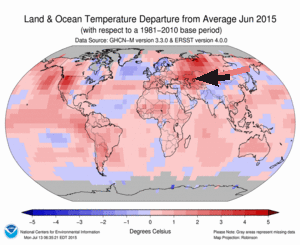
Lednik Midagrabin is a large glacier draining northwest from Gora Dzhimara in North Ossetia, Russia.  Stokes et al (2006)  examined Caucasus glaciers during the 1985-2000 period and found that 94% of the glaciers have retreated, 4% exhibited no overall change and 2% advanced. The mean retreat rate is 8 m/year, with the largest glacier retreating the fastest. Shahgedanova et al (2009) observed that the retreat was driven by a large rise in summer temperature in the alpine zone, and that this will continue and generate substantial changes in the timing and amount of glacier runoff.  Here we examine the changes in this glacier from 1989-2015. This region has had a particularly warm start to the melt season in 2015 prompting this examination, note the NOAA temperature anomaly for the Caucasus Region.

midagrabin 2010 ge

Google Earth Image

201506


NOAA 2015 Temperature departure map for June 2015 with the Caucasus region indicated.

The glacier begins on the slopes of Dzhimarra at 4200 m and in 1989 the glacier terminated at the red arrow at 2950 m.  The snowline at the end of August, 1989 was 3700 m.  The green arrow indicates the extent of the clean blue glacier ice of the tributary from the north  In 2014 the glacier had retreated to a terminus location at the red arrow.  The snowline at the end of August 2014 was at 3800 m.  In mid-July of 2015 the snowline has already reached 3700 m, with the melt season only half over.  This will lead to substantial mass loss.  The main terminus has retreated to the yellow arrow a distance of 900-1000 m since 1989 and now terminates at 3050 m.  This is close to the maximum rate of 38 m/year identified by Stokes et al (2006) for the any glacier in the mountain range from 1985-2000.  This indicates Midagrabin is one of the faster retreating glaciers in the Caucasus and that the rate of retreat has increased.  The northern tributary clean ice zone has been reduced in length and width, now terminating 600 m further upglacier.  The northern tributary has had little retained snowpack in 2014 and again in 2015.  The tributary begins at 4000 m, which is not high enough in recent years to sustain this arm of the glacier.  The high snowlines of recent years will lead to continued retreat. The glacier poses little geologic hazards of flooding compared to some other retreating glaciers in the area such as Bashkara Glacier.

Midagrabin 1989

August 1989 Landsat Image

midAGRABIN 2014

August 2014 Landsat Image

midagrabin 2015

July 2015 Landsat image


Dzhikiugankez Glacier Poised to Melt Away, Mount Elbrus, Russia.

Dzhikiugankez Glacier (Frozen Lake) is a large glacier on the northeast side of Mount Elbrus, the highest mountain in the Caucasus Range. The primary portion of the glacier indicated in the map of the region does not extend to the upper mountain, the adjoining glacier extending to the submit is the Kynchyr Syrt Glacier. The glacier is 5 km long extending from 4000 m to 3200 m. Shahgedanova et al (2014) examined changes in Mount Elbrus glaciers from 1999-2012 and found a 5% area loss in this short period and accelerated retreat from the 1987-2000 period. As examination of Landsat images indicates Dzhikiugankez Glacier has the lowest percent of overall snowcover, as seen in the satellite image from August 2013 with the transient snow line shown in purple. The amount of blue ice is apparent on Dzhikiugankez Glacier (D). The main changes in this glacier are not at the terminus, but along the lateral margins, indicating substantial vertical and lateral thinning. Here we examine Landsat imagery from 1985 to 2013 to identify changes. In each image the red arrow indicates bedrock on the western margin, the yellow arrow bedrock on the eastern margin, Point A an area of glacier ice extending to the upper eastern margin, the purple arrow a medial moraine exposed by retreat and the green arrow the 1985 terminus of the glacier.

Elbr01
Map of northeastern side of Mount Elbrus, summit on left. Dzhikiugankez Glacier (Dzhikaugenkjoz) is outlined in black.

elbrus glaciers tsl 2013
August 2013 Satellite image of Mount Elbrus

kinger sirt ge
Google Earth image 2013

In 1985 the glacier connects beneath the subsidiary rock peak at the red arrow, a tongue of ice extends on the east side of the rock rib at the yellow arrow, Point A. The transient snow line is at 3550 m and less than 30% of the glacier is snowcovered. The medial moraine at the purple arrow is just beyond the glacier terminus. In 1999 the subsidiary peak is still surrounded by ice and the tongue of ice at Point A though smaller is still evident. The snowline is quite high extending to 3750 m, leaving only 10-15% of the glacier snowcovered. In 2001 the main terminus has retreated from the green arrow. A strip of rock extends up to the red arrow. The snowline is at 3500 m, with a month of melting left. In 2013 a wide zone of bare rock extends up to the subsidiary peak at the red arrow.  The medial moraine, purple arrow is exposed all the way to its origin near the red arrow.  In 2013 the tongue of ice at Point A, is gone.  This glacier is retreating faster on its lateral margins as  at the terminus, a 20% reduction between red and yellow arrows from 1985 to 2013. The snowline is at 3600 m, with several weeks of the melt season left. The key problem for the Dzhikiugankez Glacier is that there is an insufficient persistent accumulation zone.  Pelto (2010) noted that a glacier cannot survive without a persistent and consistent accumulation zone, which Dzhikiugankez Glacier lacks despite being on the flanks of Mount Elbrus. Retreat of this glacier is similar to Azau Glacier, particularly the west slope of this glacier, and Irik Glacier.  Unlike these glaciers it cannot survive current climate.  The glacier is large and the glacier will not disappear quickly. Shahgedanova et al (2014) note the expansion of bare rock areas adjacent to glaciers on the south side of Mount Elbrus including Azau and Garabashi.

lednik ks 1985
1985 Landsat image

lednik ks syrt 1999

1999 Landsat image
lednik ks 2001
2001 Landsat image

lednik ks 2013
2013 Landsat image

Irik Glacier Retreat, Mount Elbrus, Russia

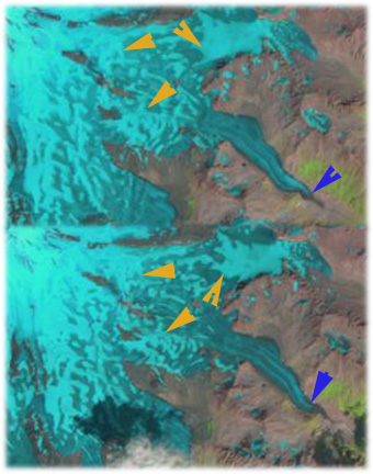
Irik Glacier flows down the southeast flank of Mount Elbrus, the highest peak in the Caucasus Mountains of Russia, red arrow on map points to current terminus of Irik Glacier, top image. The map terminus extended 1 kilometer further down the mountain. The glacier currently begins at 5000 m and descends to 2800 m, bottom image orange arrows indicate main accumulation areas, this compares to a terminus elevation of 2600 meters on the map.A decrease of area of glaciers of the Central Caucasus by 16% in the last 40 years is reported, on Elbrus the loss has been 8 % Russian Academy of Sciences National Geophysical Committee (2011). August 1998 (Top) and 2010 image (bottom) indicate the snowline on Irik Glacier, orange arrows and the glacier terminus blue arrows. The fraction of the glacier that is snowcovered is the accumulation area ratio (AAR), typically a glacier needs an AAR of 0.5-0.65 at the end of the melt season in September to be in equilibrium. For the nearby Djankuat Glacier, where annual mass balance data is reported to the World Glacier Monitoring Service, the AAR value for equilibrium is reported as 0.55. For Irik Glacier in 1998 and 2010 the AAR is 32 and 28 respectively and this is still with several weeks of melting. By the end of the melt season both would be below 0.3. The result of consistent negative balances is glacier retreat. For Irik Glacier the retreat from 1998 (top) to 2010 (bottom) is 600-700 meters, note blue arrows indicating terminus location and red arrow indicating a small rise on the southwest side of the glacier that the glacier used to wrap around, but no longer does. In a Google Earth image from 2009 the lower of the glacier is narrow and uncrevassed, this is a section that is quickly melting away. The orange arrows point out the lateral moraines from the Little Ice Age, the blue arrow the 1998 terminus and the red arrow the terminus in 2010. Irik Glacier must retreat to attempt to reestablish equilibrium with climate warming that has reduced the accumulation area. At present the lower 300 meters of the glacier is not crevassed and will melt away. Above that point the glacier is crevassed and vigorous in its flow.