Cloud Peak Glacier Retreat, Wyoming

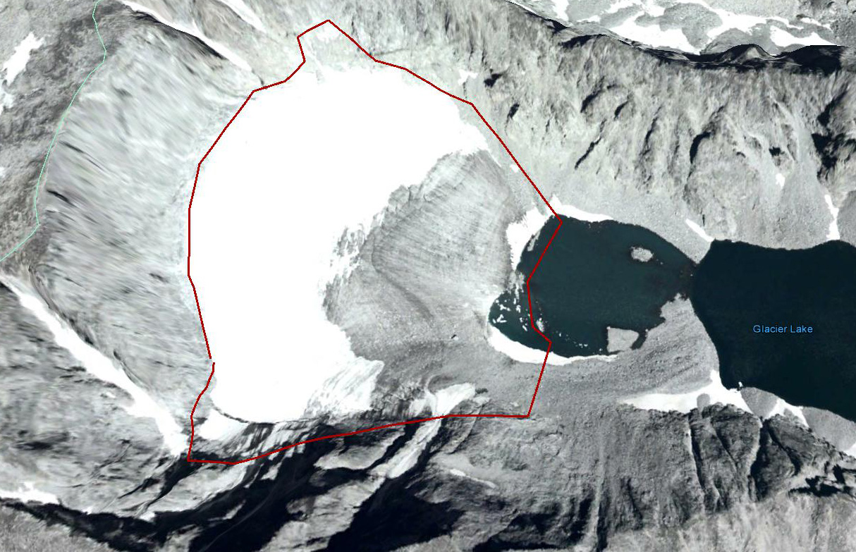
Cloud Peak is the highest peak in the Bighorn range of north central Wyoming, a cirque on its east side hosts the only significant glacier in the range. This glacier was photographed in 1903 and has lost much of its volume since then. Rahn et al. (2006), page 44, estimated that if the melting continues at the rate that determined in 2005, Cloud Peak Glacier would disappear between the years 2020 and 2034. They used repeat photographs to estimate glacier volume as 506 million cubic feet in 1905, 205 million cubic feet in 1966 and 78 million cubic feet in 2005. The latter value is likely too low, as it implies a glacier thickness of just over 10 m on average, yet there is active crevassing, which typically requires 30 meters of thickness. A typical volume-area scaling law also yields a thickness of 30 m (Bahr, 2014).

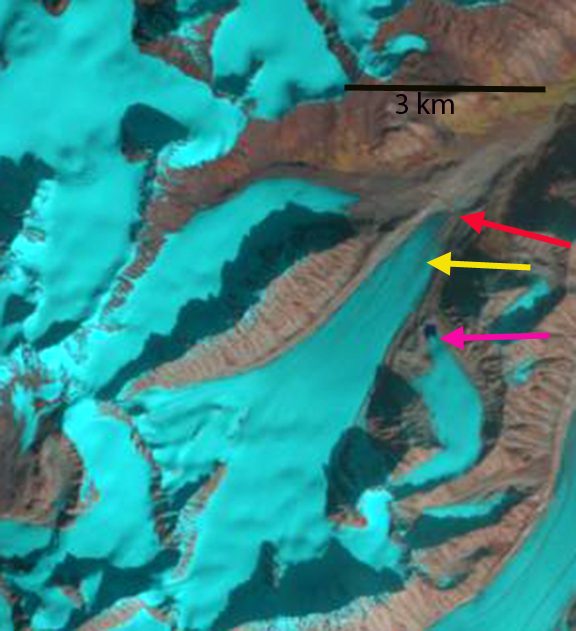
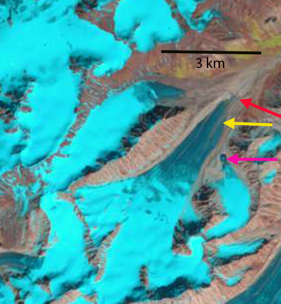
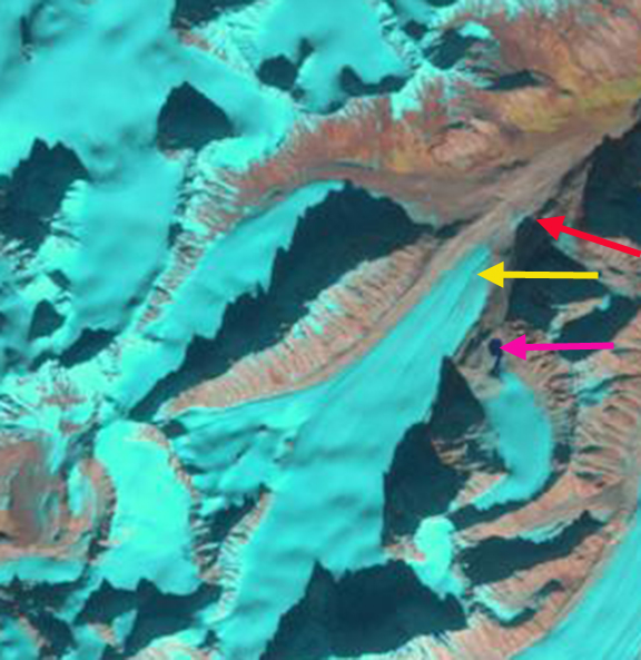
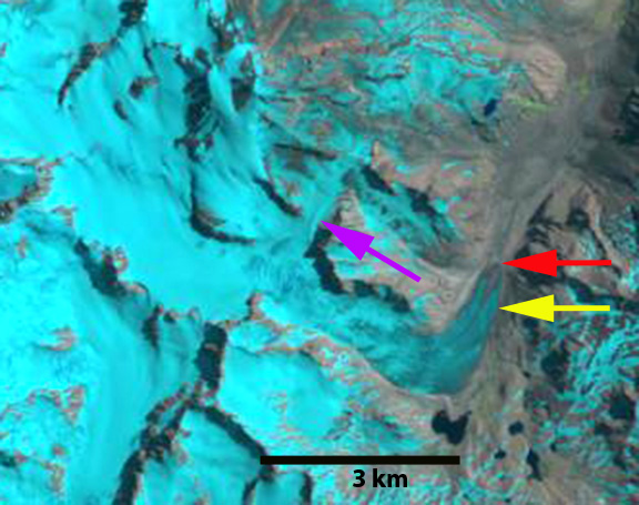
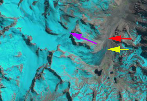
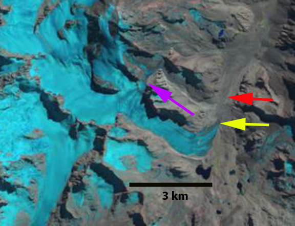
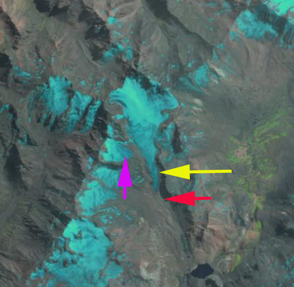
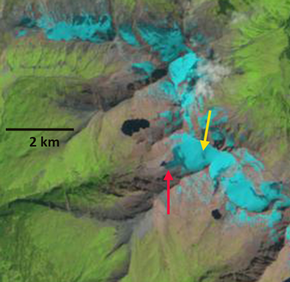
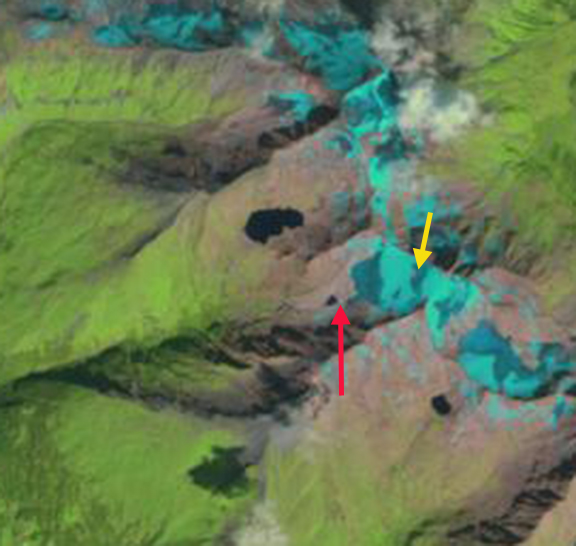
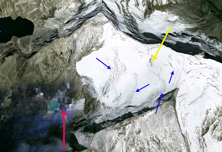
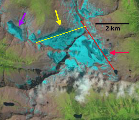
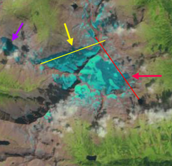
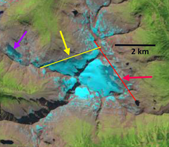
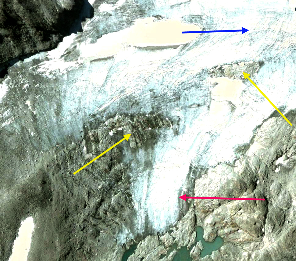
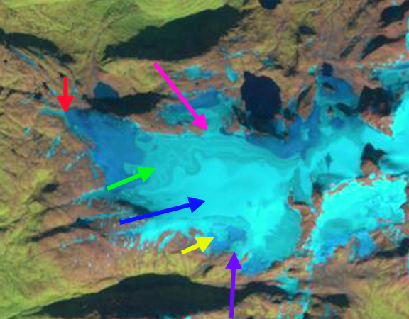
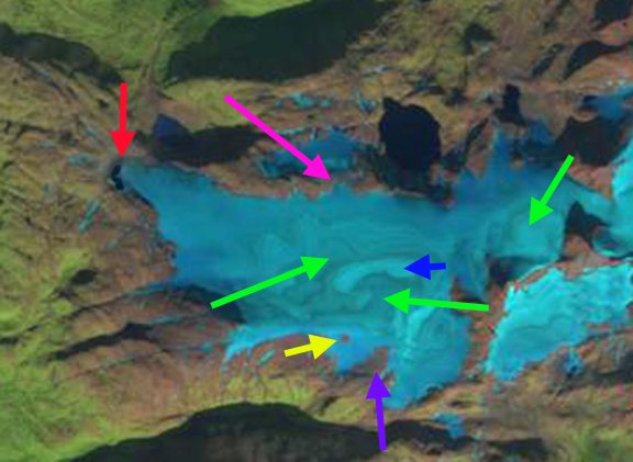
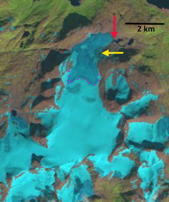
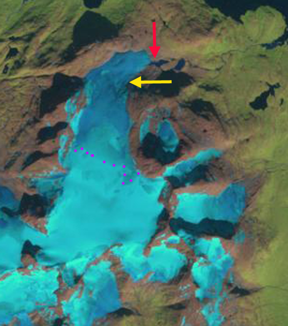
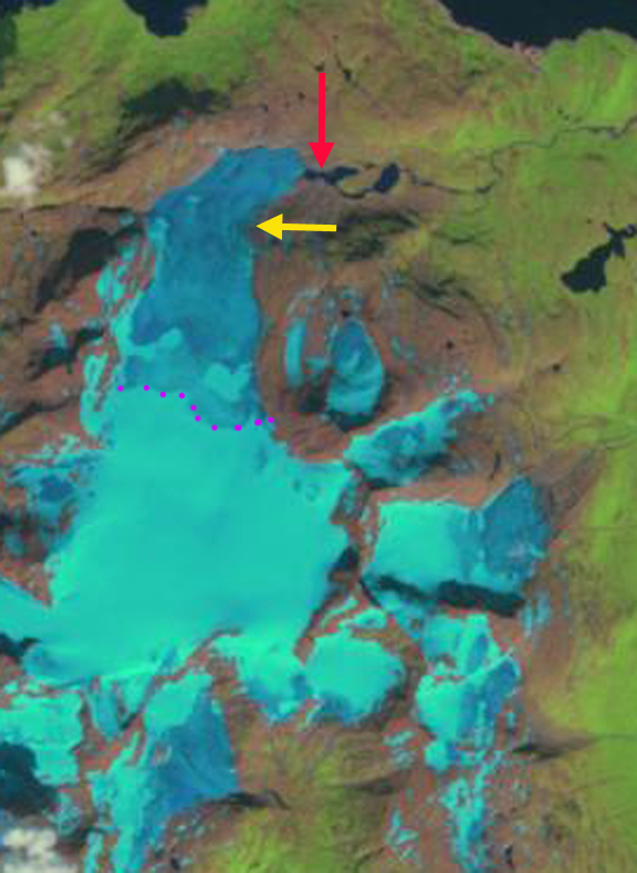
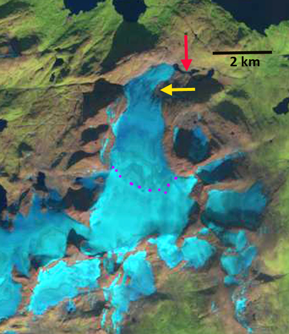
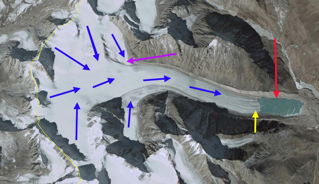
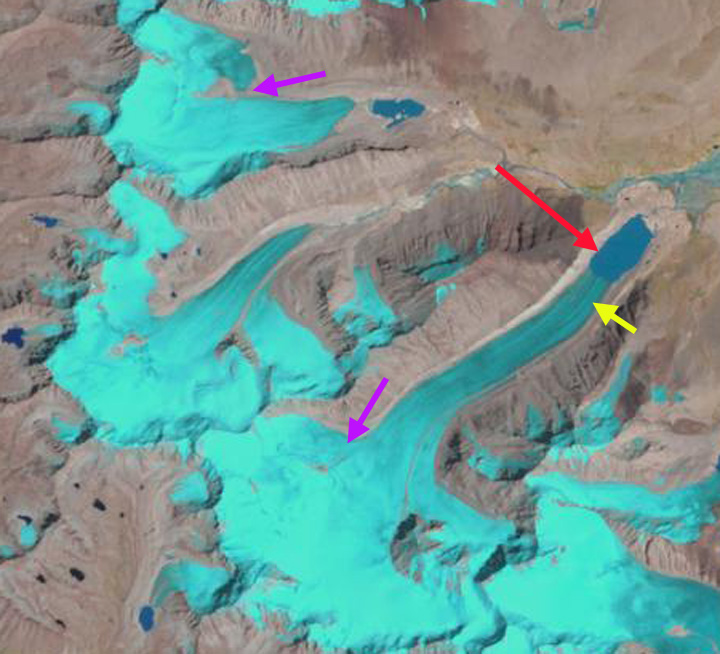
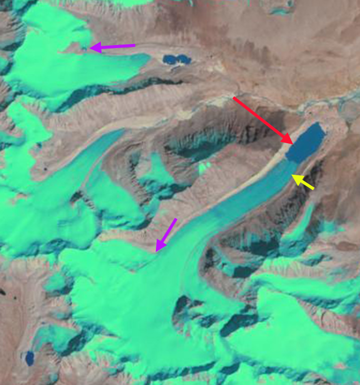
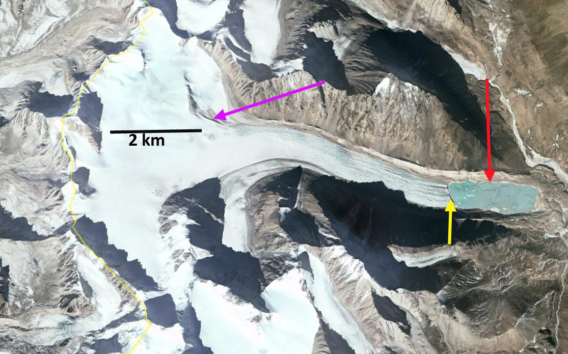
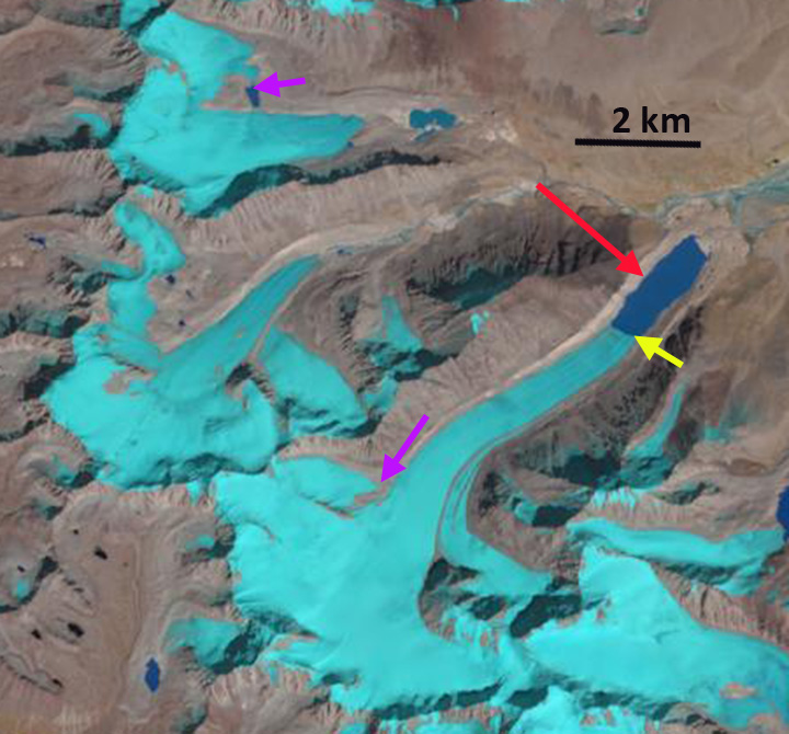
Here we use Google Earth images from 1994, 2006 and 2010 to observe more recent changes. The red line is the outline of the glacier in 1994. In 1994 the glacier had a length of 580 m on average across the glacier front. The glacier had retreated 280 m from the Little Ice Age moraine crosscutting the lake. By 2006 the terminus has retreated 65 m. In 2010 the terminus has retreated an average of 105 m. Just as importantly the top of the glacier has receded 75 m, pink arrows indicate this area. The net results is that total glacier length has declined from 580 m to 380 m on average. The glacier has an area in 2010 of 0.20 square kilometers. Given retreat of the top and bottom of the glacier the glacier will not survive (Pelto, 2010). However, the glacier will not disappear in the next two decades unless the melt conditions increase substantially. This retreat is similar to the nearest glaciers to the north in the Beartooth Mountains of Montana and to the west in the Wind River Range of Wyoming.

cloud peak 1994
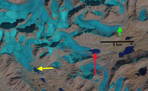
1994 Google Earth Image
cloud peak 2006
2006 Google Earth image
cloud peak 2010
2010 Google Earth image

Sovereign Glacier Retreat, Talkeetna Mountains, Alaska

Sovereign Glacier is on the northeast side of the Talkeetna Mountains, Alaska and drains into the Talkeetna River. The Sovereign Glacier, red arrow, was joined by a tributary from the south in the map image, pink arrow. Molnia (2007) noted that all glaciers in the region have retreated since the early 1950’s when the area was mapped and that all the major termini were retreating and thinning in 2000. Here we examine Landsat imagery from 1986 to 2014.
talkeetna_mountains-1983
In 1986 the glacier terminates at the red arrow at the valley junction. The tributary to the south, pink arrow has separated from the main glacier and ends in a proglacial lake. In 1989 retreat is evident during the last three years with an expanding proglacial lake at the pink arrow, and the glacier terminus no longer reaching the valley junction, red arrow. By 2001 the glacier has retreated most of the distance from the red arrow at the 1986 terminus location to the yellow arrow, the 2014 terminus location. The former tributary glacier has receded from the proglacial lake. In 2009 there are two new outcrops of bedrock in the upper portion of the glacier indicating glacier thinning near the equilibrium line at 2000 m, at green arrow. By 2014 the main glacier has retreated 1100 m from the 1986 position, red arrow, to the yellow arrow. The tributary glacier at the pink arrow has retreated 400 m since 1986. The green arrow indicates further thinning of the upper glacier since 2009. The thinning upglacier indicates that retreat will continue. The retreat parallels that of nearby South Sheep River Glacier. This thinning in the upper glacier is similar to that of Lemon Creek Glacier as well (Pelto et al, 2013).
sovereign Glacier 1986
1986 Landsat image
sovereign Glacier 1989
1989 Landsat image

sovereign Glacier 2001
2001 Landsat image

sovereign Glacier 2009
2009 Landsat image

sovereign Glacier 2014
2014 Landsat image

South Sheep River Glacier Retreat, Alaska

South Sheep River Glacier is the informal name of the longest glacier in the Talkeetna Mountains of Alaska. This glacier is the headwaters of the Sheep River and is comprised of two major glacier branches from the east and west meeting and turning north down the Sheep River valley. Molnia (2007) noted that all glaciers in the region have retreated since the early 1950’s when the area was mapped. Molnia (2007) noted that all the major termini were retreating and thinning in 2000. Here we examine Landsat imagery from 1986 to 2014. In the early 1950’s the glacier extended 5.5 km north down the Sheep River Valley from the main glacier junction, red arrow.
sheep river glacier map
USGS Map
In each image the red arrow indicates the early 1950 terminus position, the yellow arrow the 1986 terminus and the pink arrow the 2014 terminus position. In 1986 the glacier had retreated 2.5 km from the 1950’s position. The terminus is at the mouth of the first significant glacier valley draining into the Sheep River from the west. The medial moraine extending to the terminus from the glacier junction is quite prominent. There is a small tributary at Point A that joins the eastern branch of the glacier. In 1989 the snowline on the glacier is at 1700 m. By 2001 the glacier has retreated substantially from the yellow arrow and side valley from the west. In 2009 the snowline is quite high at 2000 m. Th eastern tributary is quite thin beyond the junction, and adds little ice to the now short northward flowing segment. The late Sept. 2014 Landsat image is after a fall snowstorm and the snowline has lowered. The terminus is now at the pink arrow a 4.5 km retreat since the early 1950’s. The glacier has retreated 2 kilometers since 1986. The tributary at Point A now terminates 600 meters from the eastern branch. The glacier flows just 1 km north from the main junction versus 5.5 km in 1950. The terminus remains thin, and the narrow eastern tributary appears ready to separate from the west flowing tributary. This is not an imminent change, but is inevitable. The retreat is the same as that of nearby Sovereign Glacier and glaciers to the south, Pedersen Glacier and Fourpeaked Glacier
sheep river glacier 1986
1986 Landsat image

sheep river glacier 1989
1989 Landsat image

sheep river glacier 2001
2001 Landsat image

sheep river glacier 2009
2009 Landsat image

sheep river glacier 2014
2014 Landsat image

Kuh-E Myana Glacier Retreat, Afghanistan

Kuh-E Myana Glacier is in Hindu Kush Range in Badakhshan Province of northeast Afghanistan.  This region of the Hindu Kush has not been the focus of detailed glacier study. Northeast of Takhar Province in the Wakhan Corridor a group of glaciers was examined by Umesh Haritashya and others (2009) and found 28 of thirty had retreated. Examples are Zemestan Glacier and Tchap Dara Valley. The Hindu Kush follows the pattern of the high mountains of central Asia including the Himalaya
Kuh E Myana map
kuhemyana ge
2004 Google Earth image
Here we examine the changes of the glacier from 1998-2014 using Landsat imagery.  In 1998 the glacier ended in a small proglacial lake, red arrow.  A nunatak is at Point A. In 2002 the glacier still reaches the edge of the proglacial lake.  A small niche glacier is indicated by the yellow arrow.  The 2004 Google Earth image indicates an expansion of the proglacial lake, and that the glacier terminus is quite thin.  By 2014 the glacier has retreated 250 from the proglacial lake, red arrow. The majority of this retreat has occurred in the last decade. The glacier has retreated 1200 m from the Little Ice Age moraines to the 2004 terminus, green arrows on 2004 terminus image.  The retreat since 2004 is much faster than the overall retreat. The nunatak at Point A has expanded.  The niche glacier at the yellow arrow has developed a pair of substantial bedrock gaps as the thinning glacier disappears. kuhemyana 1998
1998 Landsat image
kuhemyana 2002
2002 Landsat image
kuhemyana terminus
2004 Google Earth Image
kuhemyana 2014
2014 Landsat image

Tchap Dara Valley Glacier Retreat, Afghanistan

The Wakhan Corridor in Afghanistan is quite remote. A look at maps or Google Earth will indicate the lack of even place names except in the main river valleys. The Secret Compass uses this fact to advantage for expeditions in the region. Here we examine three glaciers north of Sarhad two draining into the Tchap Dara Valley. Haritashiya et al (2009) examined fluctuations of 30 Wakhan Cooridor glaciers from 1976-2003. They found that 28 of the glaciers had retreated.
Here we examine Landsat images from 1998, 2002 and 2013 with the green arrows pointing the 2013 terminus position of the northern glacier, the red arrows to the 1998 terminus position of the center glacier and the yellow arrows indicating the 1998 terminus location of the western glacier. The blue arrows indicate ice flow.Tchap dara ge
Google Earth image

In 1998 the red arrow indicates the terminus of the center glacier, which also has an ice cored medial moraine that extends nearly across the entire proglacial lake that the glacier terminates in. The northern glacier extends beyond the green arrow. The western glacier extends to the yellow arrow filling much of a small basin. In 2002 there is little evident change at the northern glacier. The center glacier has retreated leading to lake expansion, and the medial moraine extending into the lake is also shorter. The western glacier no longer reaches the yellow arrow. By 2013 the northern glacier has retreated 200 meters to the green arrow. The center glacier has retreated 400 m leading to the same amount of lake expansion, the medial moraine no longer extends into the main lake basin. The western glacier no longer reaches a lake that has developed in the basin at the 1998 terminus position. The retreat is 300-400 meters. The retreat over 15 years is substantial for small glacier like this. This parallels the retreat at nearby Zemestan Glacier and the Emend River headwaters glaciers.tchap Dara 2013
1998 Landsat image

tchap dara 2002
2002 Landsat image

tchap dara 2014
2013 landsat image

Cortaderal Glacier Retreat, Chile

Cortaderal Glacier is in central Chile on the south slope of Paloma a stratovolcano. The glacier feeds the Cortaderal River which joins the Cachapoal River. Pacific Hydro has opened a new hydropower plant at Chacayes that is fed by this and other glaciers. It is a 111 MW run of river project with water taken out at a small dam run through a canal a small reservoir and back into the river. There is an older Coya Hydropower Plant a short distance downstream. Pacific Hydro plans to add several more plants in the area.  Continued glacier retreat in the regions will lead to further glacier runoff declines during the melt season.cortaderal ge 2007
Cortaderal Glacier Google Earth image

chacayes intake
Chacayes Hydropower intake and canal

chacayes canal
Chacayes Hydropower Canal and Reservoir

coya hydro
Coya Hydropower Plant
La Quesne et al (2009) reported a that Cortaderal Glacier retreated 110 m from 1970-2000 and 450 m from 2000-2007. Here we use satellite imagery from 1990-2014 to observe this retreat and more recent changes. In each image the red arrow is the 1990 terminus the 2014 is marked by a yellow arrow and the purple arrow a smaller side glacier feeding a secondary terminus. In 1990 the glacier after descending turned north in the main river valley and extended 1 km north. The side glacier has a significant width of 300 m. By 2000 the glacier had retreated 300 m and with a high snowline the connection to the secondary terminus at the purple arrow is narrowing but still significant. In 2003 further change is hard to discern. In 2013 substantial further retreat has occurred, the snowline is high at 3800 m and the secondary terminus connection is nearly gone. By 2014 the retreat since 1990 is 800 to 900 m, the snowline is at 3700 m and the secondary terminus connection is to narrow to actually feed glacier ice.  The retreat here is similar to that of nearby Glaciar del Humo, Argentina.  The Laboratorio de Glaciologia in Valdivia, Chile, Rivera et al (2002), has noted the extensive retreat of the Central Chile glaciers over the last four decades.
cortaderal 1990
1990 Landsat image
cortaderal 2000
2000 Landsat image
cortaderal 2003
2003 Landsat image
cortaderal 2013
2013 Landsat image
cortaderal 2014 2014 Landsat image

Glaciar Del Humo Retreat, Argentina

Glaciar del Humo is in the Mendoza Province of Argentina. It drains into Lago Atuel and is one of the headwaters of Rio Atuel. Rio Atuel has hydropower development above and within the Rio Atuel Canon. The Nihuil dam and reservoir above the canyon and four more dams within the canyon, including Valle Grande Reservoir.
Le Quesne et al (2009) examined the retreat of glaciers in the Central Andes and reported the retreat of Glaciar del Humo as 3200 m from 1914-1948, 700 m from 1948-1970 and 660 m from 1970-2007. Here we utilize Landsat imagery to observed changes from 1990 to 2014. humo glaciar ge
Google Earth Image

atuel river hydropower
Google Earth Image of Valle Grande Reservoir on Rio Atuel

In each image the red arrow marks the 1990 terminus, the yellow arrow the 2014 terminus and the purple arrow a glacier on the west side of Humo. In 1990 the Glaciar del Humo extended down valley ending at the red arrow at 3200 m. The side glacier ended less than 200 m from the main glacier. By 2000 the terminus had retreated 250 m. In 2003 there is little change from 2000. By 2013 the side glacier is separated by 350-400 m from the main glacier. The snowline is in the main accumulation of the glacier. In 2014 the glacier has retreated 900 m from the 1990 terminus position. The terminus is quite thin indicating that retreat will continue. There is also limited retained snowpack on the glacier in 2014, which would lead to mass losses and ongoing retreat. The retreat of this glacier follows that of others in the region, note maps from Glaciares de Argentina

hulo glaciar 1990
Landsat image 1990
hulo glaciar 2000
Landsat image 2000

hulo glaciar 2003
Landsat image 2003

hulo glaciar 2013
Landsat image 2013

hulo glaciar 2014
Landsat image 2014

Kleinfleisskees Retreat, Austria

Kleinfleisskees is a small glacier in the Hohe Tauern region in the eastern Austrian Alps. The glacier had an area of 0.87 km2 in 2004 (Binder, 2006). The glacier is located adjacent to the Sonnblick Observatory (3106m), which has both a long term climate record and a webcam.The mass balance of this glacier has been assessed since 1999 (Hynek et al, 2011). From 1999-2012 the glacier has lost 7 m of water equivalent, which is over 8 m of glacier thickness. (WGMS). Unger et al. (2012) produced a map of the changes in this and other nearby glaciers from 1850 to 2009 that was published by WGMS. Here we examine changes in the glacier from 1990 to 2013 using Landsat and Google Earth imagery.

Kleinfleiss change map
Unger et al (2012) Map of glacier change.

In each image the red arrow indicates the 1990 terminus and the yellow arrow an outcrop of rock that emerges after 1990. In 1990 the glacier extends to a small lake, red arrow. This terminus tongue is 200 meters wide and 300 meters long. At the yellow arrow the annual snowcover has been lost and glacier ice is exposed. In 2001 the terminus tongue has nearly disappeared and the glacier no longer reaches the lake. The yellow arrow again indicates a location where snowcover has been lost and a large area of glacier ice exposed, with the hint of bedrock emerging. By 2013 the glacier terminus tongue is gone, the glacier has retreated 400 m from the 1990 position, with most of the retreat occurring by 2005. An area of bedrock has emerged at the yellow arrow as the glacier ice covering of this location has been lost. Retreat from 2006-2013 was minor according to the WGMS and the Austrian Alpine Club Inventory. In 2012 this survey found 94 glaciers in retreat and 2 stationary out of 96. In 2012 and 2014 glacier mass balances have been quite negative on the glacier, which will fuel more retreat. The glacier lost nearly its entire snowpack in 2014 as seen from the webcam at Sonnblick Observatorium on August 9th. Fortunately several late summer snowstorms prevented high ablation after this date. This glacier does continue to have significant crevassing indicating a good flux towards the terminus in the Google Earth image of 2006. The glaciers retreat is similar to that of Hochalm, Oschentaler and Rotmoosferner.
kleinfleisskees 1990
1990 Landsat image
kleinfleisskees 2001
2001 Landsat image
kleinfleisskees 2013
2013 Landsat image
sonnblikes obs
Sonnblick Observatorium image from 8/9/2014
KleinFliess Glacier ge
Google Earth image from 2006.

Hochalm Glacier Retreat, Austria

Hochalm Glacier is Austrian Alps. The glacier drains into the Malta River, which hosts a 40 MW run of river hydropower plant. Fischer et al (2014) note that the Ankogel-Hochalmspitzegruppe glacier area has declined from a Little Ice Age extent of 39.7 square kilometers, 19.2 square kilometers in 1969 to 16.0 square kilometers in 1998 and 12.1 square kilometers in 2012. They note the disintegration and separation of many glaciers in the region. The World Glacier Monitoring Service reported the terminus retreat of 80 m for Hochalm Glacier from 2001-2010.

Here we examine the Hochalm Glacier and two neighboring glaciers and their response to climate change from 1990 to 2013 using Landsat imagery. The red line in each Landsat image is in the same location cutting across the Hochalm Glacier. The yellow line is in the same location transecting the Grosselend Glacier. In 1990 Hochalm Glacier has two termini tongues and has a width of 1.1 km extending past the red line. On Grosselend Glacier the terminus area extends beyond the yellow across the entire width of the glacier. The purple arrow indicates a small pocket glacier that has an area of approximately 0.45 square kilometers. In 2000 the Hochalm Glacier has just two narrow termi extending past the red line. The Grosselend Glacier still extends beyond the yellow line. In 2013 the southern terminus of Hochalm Glacier has disintegrated and only the northern terminus reaches the red line. On Grosselend Glacier approximately 40% of the glacier width reaches the yellow line, the main terminus tongue at the yellow arrow has retreated to the yellow line. The area of the glacier at the purple arrow is now 0.23 square kilometers, half of its 1990 extent.

A 2006 Google Earth image of the Hochalm Glacier’s southern terminus indicates how thin it is with no crevassing, red arrow, and several large bedrock areas amidst the glacier, purple arrow. There are numerous annual horizons exposed just below the snowline as well, blue line. The retreat of Hochalm Glacier from 1990-2013 is 200 m for the northern terminus and 450 m for the southern terminus. For Grosselend Glacier the retreat of the main terminus is 450-500 m since 1990. The retreat follows that of Austrian glaciers as a whole as noted by Fisher et al (2014), and Abermann et al (2009). The glacier is thinning even in its upper regions, which indicates it cannot survive (Pelto, 2010). The retreat of Ochsentaler, Sulztalferner and Obersublzbach Glacier indicate a similar story.
hochalm 1990
1990 Landsat image

hochalm 2000
2000 Landsat image

hochalm 2013
2013 Landsat image

Hochalm glacier ge
2006 Google Earth image

Vestisen Glacier Retreat, Norway

Vestisen Glacier is the second largest glacier of the Oksindan Icecap flows west. The glacier drains west into the Rossaga River, which has a Statkraft Hydropower plant, though upstream of the glacier inflow. Here we examine Landsat imagery from 1992-2014 to observe recent changes.
vestisen map
Vestisen Mapcarta view

In 1994 the glacier terminus is at the red arrow. The areal extent of snowcover is more than 50% of the glacier area, blue arrow. A small glacier to the north is connected to the Vestisen at the pink arrow. The purple arrow is a small bedrock ridge that intrudes into the glacier a small distance from the south, and the yellow arrow is a small side terminus of the glacier. In 1999 the snowcovered area is 35% of the glacier. The region of firn, snow that survived the first summer, but is not ice yet, green arrow, is extensive suggesting that the 1999 mass balance was more negative than recent years. In 2006 the ridge at the south edge of the glacier has expanded at the purple arrow. At the pink arrow the connection to the glacier to the north is still comprised of glacier ice. In early september of 2014 the snowcovered area is very low at 15-20% of the glacier. The glacier has separated from the glacier to the north at the pink arrow. A small outcrop of rock has appeared amidst a secondary terminus at the south side of the glacier, yellow arrow. The ridge intruding into the southern edge of the glacier is now 300-400 meters longer and is wider. A lake has formed at the main terminus. This lake has formed due to a combination of thinning and retreat of the terminus, a retreat of 250-300 m has occurred. The Mid-September 2014 image indicates the snowcovered area, blue arrow is down to 5%. The firn area, green arrow, that represents snow that had survived previous summers, is being consumed by the substantial melt of the 2014 season. To have an equilibrium mass balance glaciers in Norway need to be 55-60% snowcovered at the end of the melt season. Glacier mass balance will be quite negative in 2014, which will lead to further retreat of the main terminus and secondary terminus regions, NVE will continue its long term mass balance monitoring that will report on the particular quantities. The retreat here is less than that of Austsre Oksindbreen, just to the northeast, but it is poised for greater retreat in the near future, with poorer retained snowcover. The glacier is following a pattern of thinning and retreat over the last 15 years in Norway. The Norwegian Water Resources and Energy Directorate (NVE) reports that 23 of 24 Norway glaciers examined consistently since 2000 have retreated significantly. vestisen 1994
1994 Landsat image
vestisen 1999
1999 Landsat image
vestisen 2006
2006 Landsat image
vestisen 2014es
2014 early September Landsat image
vestisen 2014ms
2014 Late September Landsat image

Austre Okstindbreen Retreat, Norway

Austre Okstindbreen is the largest glacier of the Okstindan Icecap. It flows north from the 1700 m to a terminus in a proglacial lake at 900 m. The lake drains into Grasvatnet. The glacier had a sustained retreat of 2 km from 1908-1980, emplacing annual moraine ridges during the 1950-1968 period (Worsley and Ward, 1974). The other main glacier of the Oksindan Icecap is Vestisen. Knudsen and Theakstone (1988) identified a series of glacier dammed lake draining events from 1976-1987, with glacier retreat this is no longer occurring. Jacobsen et al (1997) noted that the lower glacier in particular had slowed down from 1976 to 1995. They also reported during a series of positive balance years the ELA averaged 1250 m. The Norwegian Water Resources and Energy Directorate (NVE) reports annual terminus of this glacier, noting a 118 m retreat from 2010-2013. Here we examine changes in the glacier from 1994-2014 using Landsat imagery. okstindbreen ge
Google Earth Image

In 1994 the glacier terminates at the red arrow, the snowline (purple dots) is at 1300 m. The width of the glacier at the eastward turn, yellow arrow is 1500 m. In 1999 the glacier has retreated a short distance and the snowline is at 1400 m. In 2006 the proglacial lake has continued to expand. The glacier width at the east turn is 1300 m. The snowline is at 1450 m. In 2014 the snowline is at 1550 m. The glacier width at the yellow arrow is down to 1100 m. The retreat from the red arrow is 400 m, which is 20 meters/year. The persistent high snowline above 1300 m in images that are not even at the end of the melt season indicate a significant rise. The 400 m reduction in the width of the glacier at the east turn, which is 1.5 km above the terminus, indicate the retreat will continue. The glacier retreat parallels that of Norway glaciers in general since 2000, with 23 of 24 glaciers examined consistently by (NVE) retreating during this interval, one was close to equilibrium. Engabreen, Tunsbergdalsbreen and Blamannsisen.

okstindbreen 1994
1994 Landsat image

okstindbreen 1999
1999 Landsat image
okstindbreen 2006
2006 Landsat image
okstindbreen 2014a
2014 Early September Landsat image
oksstindbreen 2014
2014 Mid-September Landsat image

Ribuktse Glacier Retreat, Tibet, China 1991-2014

Ribuktse Glacier drains east from 6200 m peaks along the Nepal-China border. The glacier ends in a lake that drains into Ribuktse Tso, the Yarlung Tsangpo (Zangbo), which becomes the Brahmaputra River. The Zangmu hydropower project is being constructed on the river, it is a 510 MW project. Here we examine Landsat and Google Earth imagery from the 1991-2014 period. This is a region where Li et al (2011) noted that increasing temperature, especially at altitude, the fronts of 32 glaciers have retreated, mass losses of 10 glaciers have been considerable, glacial lakes in six regions have expanded and melt water discharge of four basins has also increased. Neckel et al (2014) examined changes in surface elevation of the glaciers and found this region lost 0.44 m/year from 2003 to 2009.

ribuktse 2005
Google Earth image

In 1991 the glacier ends in a proglacial lake at the red arrow, the yellow arrow is the 201 terminus. The lake at an elevation of 5050 m is 1.1 km long and 600 m wide. The purple arrow indicates two tributaries that connect to the larger valley glaciers. By 1998 the lake has expanded. The tributary to the glacier to the north of Ribuktse has separated from the main glacier. In 2000 and 2001 the tributary to the Ribuktse Glacier is still connected to the main glacier. The terminus continues to retreat with lake expansion. By 2005 the lake is 1.8 km long and the tributary is no longer visibly in contact with the main glacier at the purple arrow. In 2014 the terminus has retreated 800 m since 1991, the lake is 1.9 to 2 km long and the tributary has significantly separated form the main glacier. At the glacier just to the north the tributary separation from the valley glacier has led to a new glacier lake developing by 2011. There is little evidence of calving from Ribuktse Glacier. The retreat of the low slope glacier tongue in the proglacial lake lacking calving will continue at a slow rate. The high elevation of the glacier terminus area limits the magnitude of ablation on the glacier tongue. The retreat follows the pattern of the Yemayndrung Glacier just to the south, Durung Drung Glacier, India, Reqiang Glacier, China and Matsang Tsanpo Glacier, China which are in a similar climate setting. This area did get an unusual heavy October snowfall from Cyclone Hudhud this week.

ribukste 1991
1991 Landsat image

ribuktse 1998
1998 Landsat image
ribukste 2000
2000 Landsat image
ribuktse 2001
2001 Landsat image

ribuktsege
2005 Google Earth image
ribukste 2014
2014 Landsat image

ribuktse north 2011
2011 Google Earth image