HPS-12, Chile Spectacular 13 km retreat 1985-2017

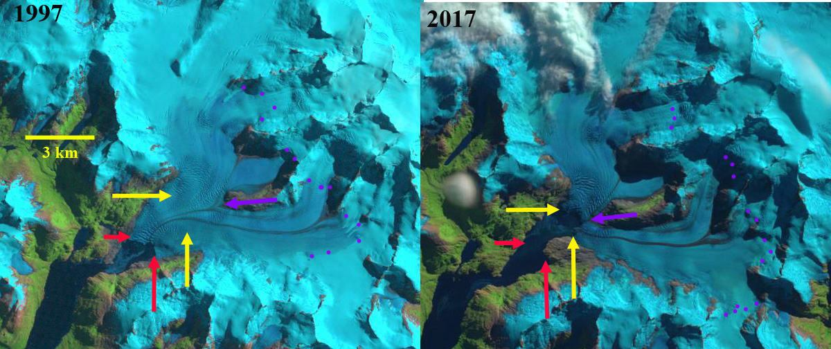
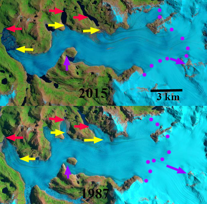
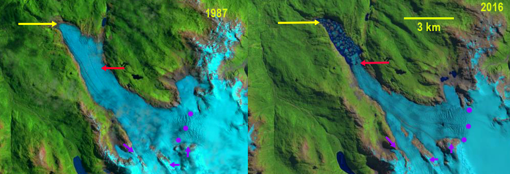
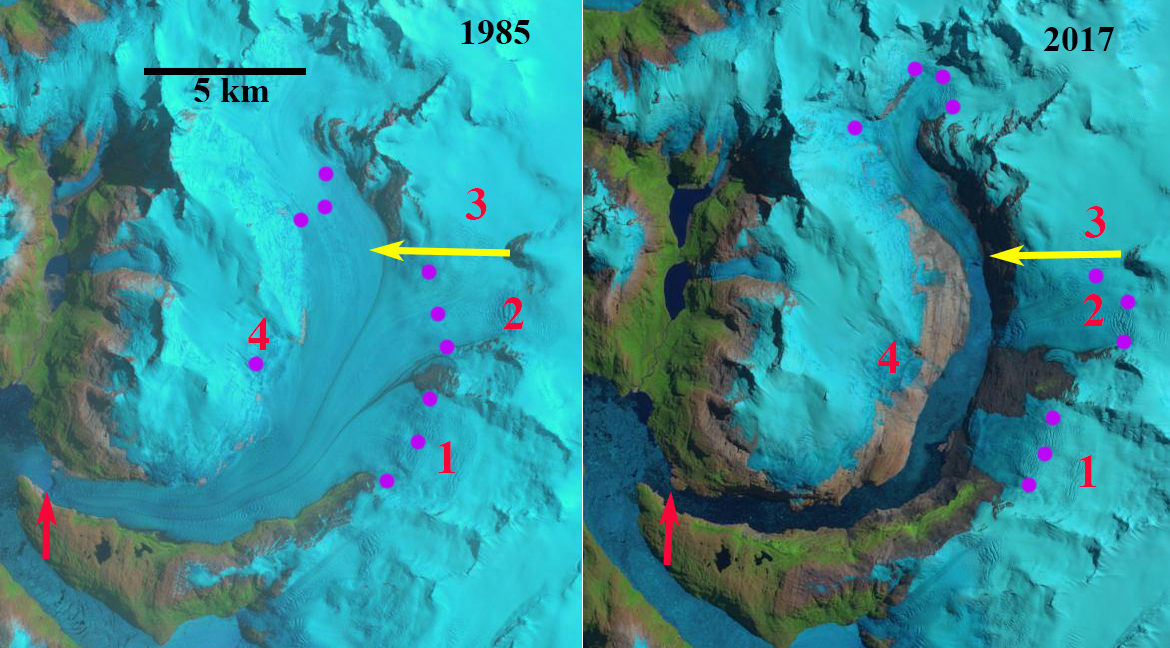
HPS-12 Glacier in 1985 and 2017 Landsat images.  The red arrow indicates 1985 terminus, yellow arrows the 2017 terminus, purple dots the snowline and 1-4 are tributaries.  By 2017 all tributaries have detached and the glacier has retreated 13 km. 

HPS-12 is an unnamed glacier draining the west side of the Southern Patagonia Ice Cap (SPI).  The glacier terminates in a fjord and is adjacent to Upsala Glacier to the east and Pio IX Glacier to the north. This developing fjord is also unnamed but feeds into Estero Falcon. The glaciers of the SPI have been experiencing significant mass loss and overall retreat. Willis et al (2012) observed significant mass loss from 2000-2012 of −20.0  Gt per year.  Willis et al (2012) indicate in Fig.1 that the majority of the ice cap has thinned during this period from 2-10 m, with the greatest thinning being in the lower portion of HPS-12. Schaefer et al (2015) indicate and ELA of 980 m and a calving velocity of 2290 m per year, which is quite high for this size of glacier.  Here we examine the retreat and fjord opening using Landsat imagery from 1985-2017.  Is it the fastest retreating glacier in Chile in the last three decades? 

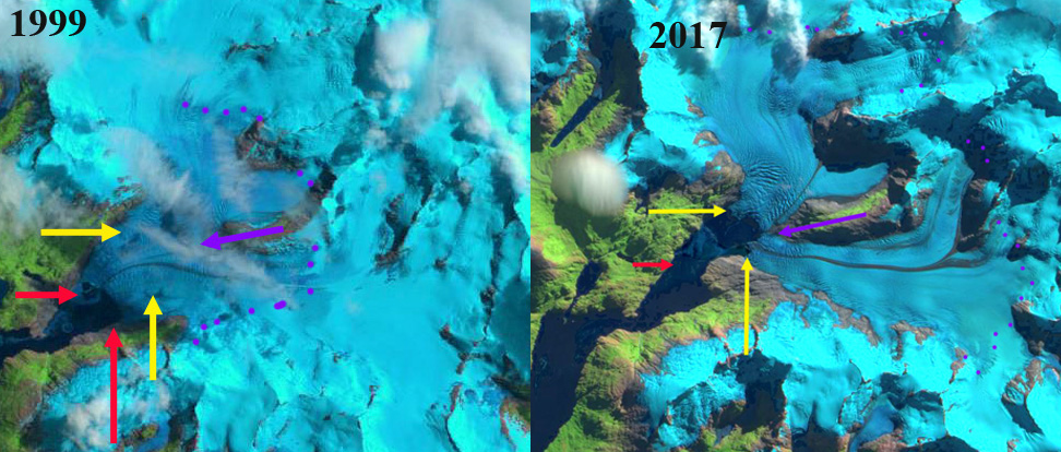
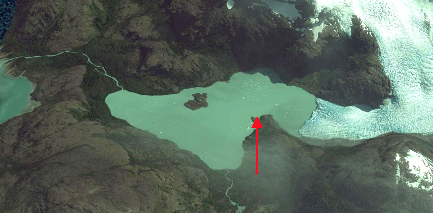
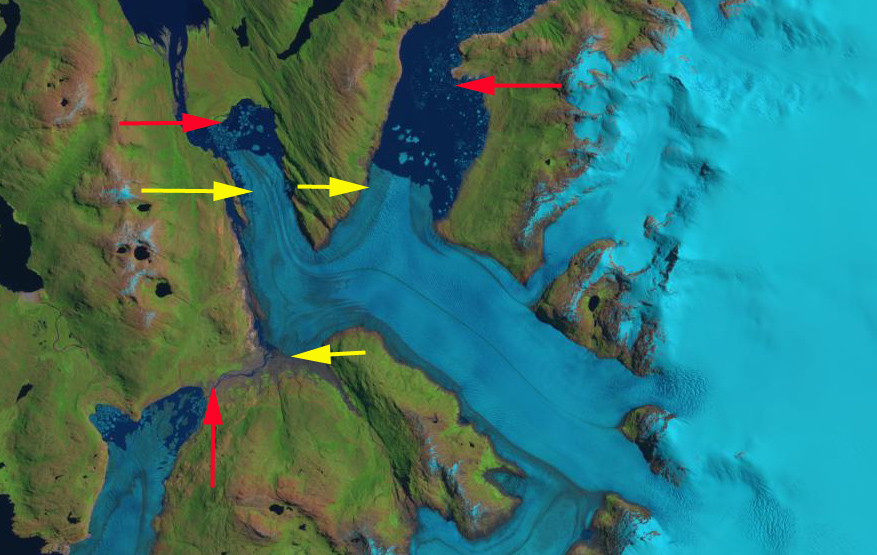
 In 1985 the HPS-12 terminates 1.5 km from the junction of two fjords that are occupied by HSP-12 and HSP-13.  These are separated by a peninsula.  The glacier is fed by four tributaries labelled 1-4. The snowline in 1985 is at 900 m.  In 2001 the four tributaries still join the main glacier, but the terminus has retreated 3.5 km.  In 2015 glacier retreat has led to separation of tributary 1, 2 and 4 from the main glacier, tributary 3 only feeds tributary 2 and not the main glacier.   The snowline in mid-January of 2015 is at 950 m.  The glacier retreat has continued to 2017, the current terminus is 800 m wide vesus 2800 m wide in 1985 at this location.  total retreat from 1985 to 2017 is 13 km.  The fjord is now nearly 15 km long.  HPS-12 was 26 km long in 1985 and is now less than  13 km long, it is 1/2 gone in three decades. This retreat along with Jorge Montt is the largest in Chile in the last 30 years. The retreat fits the pattern of large retreats of calving outlet glaciers of SPI such as Onelli Glacier, Bernardo Glacier and Lucia Glacier.

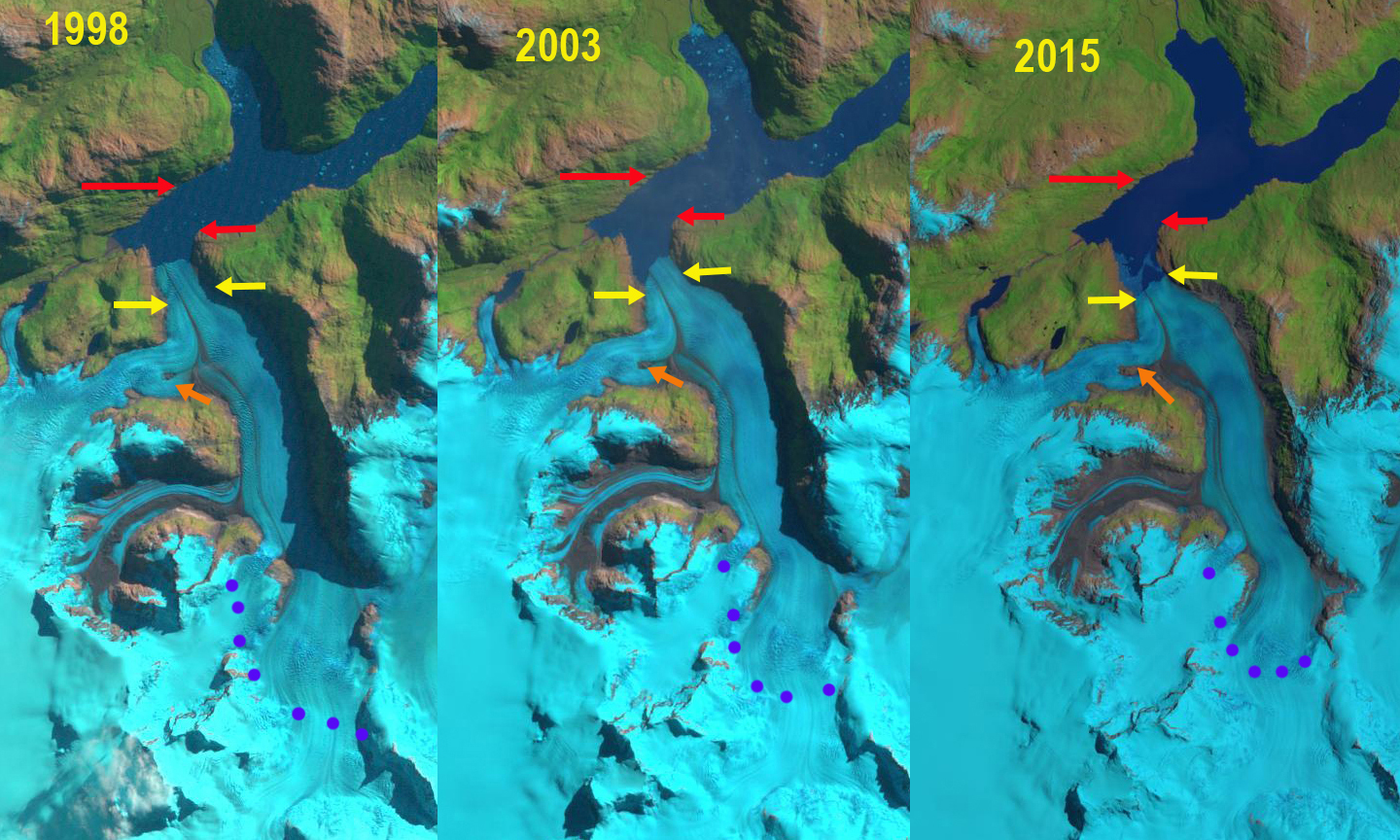
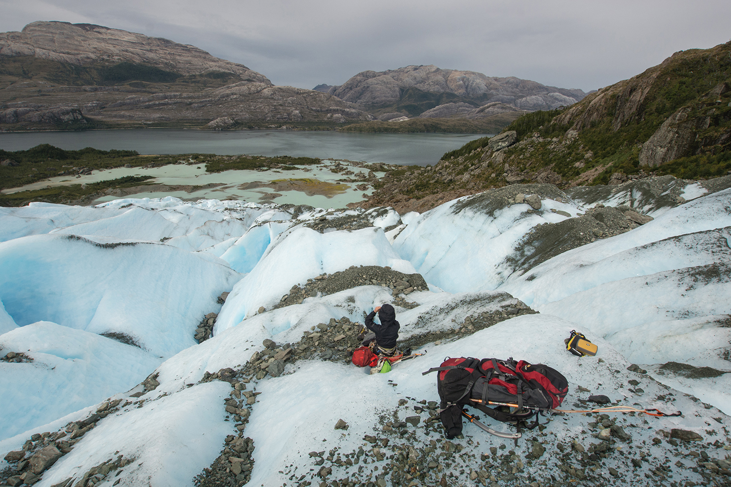
We also have a unique laboratory to examine a pristine fjord just created an the aquatic ecologic succession and physical oceanographic transitions that will occur. 

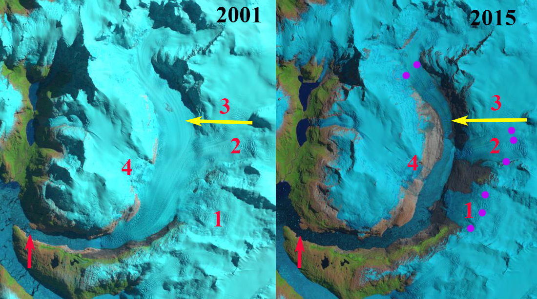
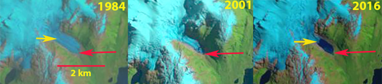
HPS-12 Glacier in 2001 and 2015 Landsat images.  The red arrow indicates 1985 terminus, yellow arrows the 2017 terminus, purple dots the snowline and 1-4 are tributaries.  By 2015 all tributaries have detached. 

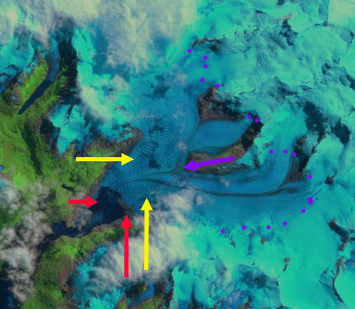
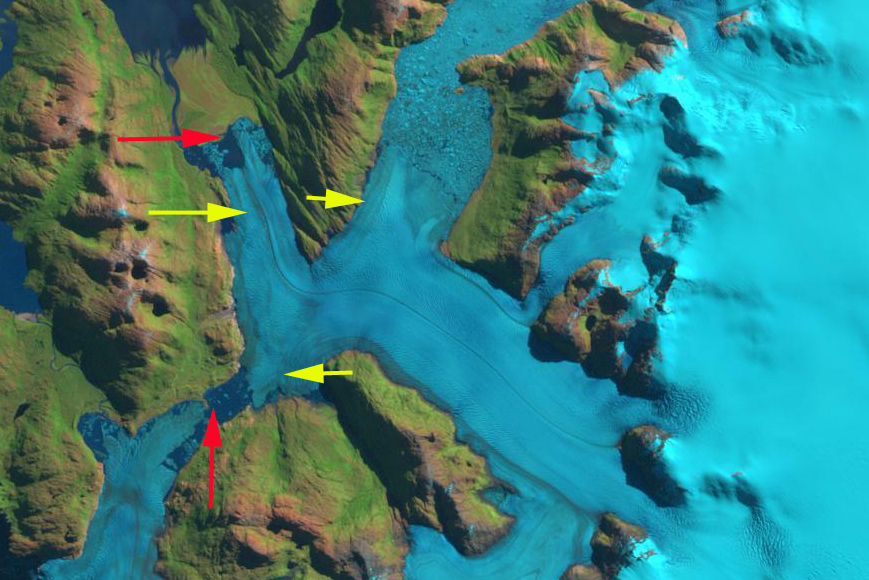
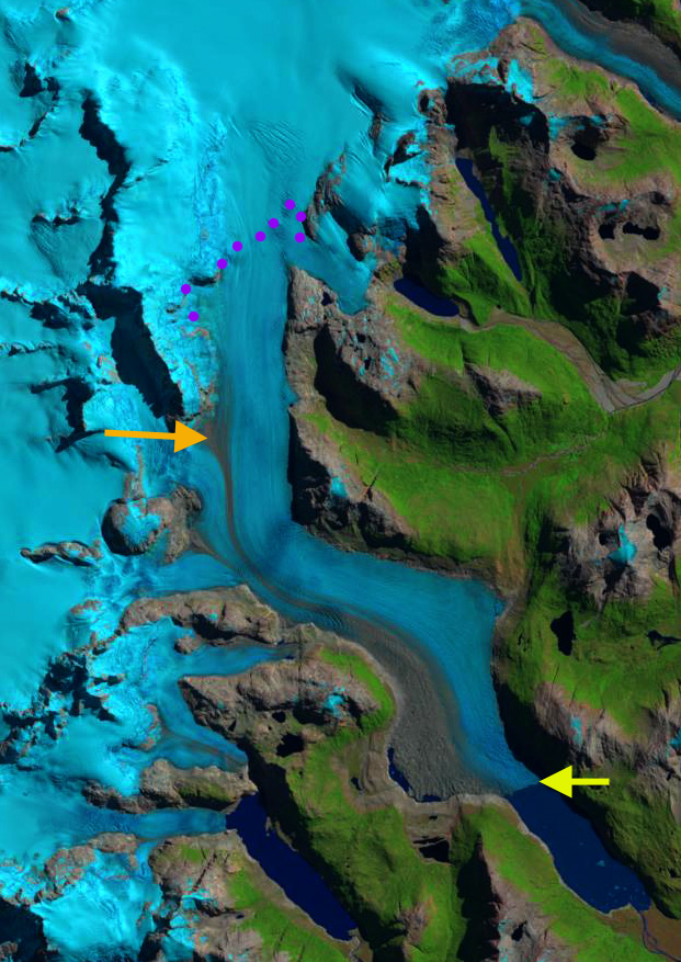
HPS-12 in 2015 Digital Globe image. Red dots indicate 1985 terminus and yellow dots 2015 terminus location for main glacier and tributaries. 


Ventisquero Grande Glacier, Chile Retreats; Not so Grande in 2017

Ventisquero Grande Glacier comparison in Landsat images from 1997 and 2017.  Red arrows mark the 1997 terminus, yellow arrows the 2017 terminus, purple dots the snowline and purple arrow the junction of the tributaries. 

Ventisquero Grande Glacier is at the head of Ventisquero Seno in the Cordillera Darwin of Tierra del Fuego.  The fjord is just west of Garibladi Fjord and opens into Darwin Channel.  Melkonian et al (2013) note widespread thinning of four large glaciers in the Cordillera Darwin Range from 2000-2011; Ventisquero Grande (CDI-08), Marinelli, Darwin and Roncagli, while the Garibaldi Glacier increased in volume.  Here we examine changes in the glacier using Landsat and Sentinel Images from 1997 to 2017.

In 1997 two tributaries merged 3.2 km upglacier of the terminus, purple arrow, terminating in a 1.8 km wide calving front, red arrows.  In 1999 there is limited retreat and the calving front has extended to 2 km in length.  The transient snowline is at 700 m in 1997 and at 550 m in 1999, purple dots.  By 2002 the southern end of the terminus has retreated exposing a shoal.  By 2017 the  two tributaries have separated, purple arrow.  Retreat of the glacier has been 2100 m on the north side, 2800 m in the center and 2000 m on the south side. Both of the termini are still calving and extensive crevassing immediately upglacier of the terminus indicates significant glacier velocities.  The calving front is 2.1 km wide in 2017.  As Simon Gascoin has noted the addition of Sentinel imagery has helped expand the potential for images that are relatively cloud free. Melkonian et al (2013) note velocities of less than 2 m/day until right near the terminus. The transient snowline in 2017 is at 800 m on March 28, 2017. 

Ventisquero Grande Glacier comparison in Landsat image from 1999 and Sentinel 2 image from 2017.  Red arrows mark the 1997 terminus, yellow arrows the 2017 terminus, purple dots the snowline and purple arrow the junction of the tributaries. 

Ventisquero Grande Glacier  in 2002 Landsat image. Red arrows mark the 1997 terminus, yellow arrows the 2017 terminus, purple dots the snowline and purple arrow the junction of the tributaries. 


Ventisquero Grande Glacier in Sentinel 2 image from 2017.  Red arrows mark the 1997 terminus, yellow arrows the 2017 terminus,  and purple arrow the junction of the tributaries. 

Lucia Glacier, Chile Retreat Opens New Embayment

Lucia Glacier retreat from 1987 to 2016 in Landsat images.  Red arrows mark 1987 terminus, yellow arrows 2016 terminus, orange arrow an emerging bedrock area, pink arrow a tributary with increased debris cover and purple dots the snowline.

Lucia Glacier terminates in Lago Berguez at the northern margin of the Southern Patagonia Icefield.  The lake drains into the Rio Pascua.   Willis et al (2012) observed that between February 2000 and March 2012 the Southern Patagonia Icefield rapidly lost volume and that thinning extends even to high elevations.   Mouginot and Rignot (2014) illustrate that velocity peaks at 1 km/year and reamins above 500 m/year  from the terminus to the accumulation zone on Lucia Glacier. The overall retreat has been driven by increasing calving rates from the 1975-2000 to the 2000-10 period (Schaefer et al, 2015). The pattern of retreat is consistent between these glaciers and the region as noted by Davies and Glasser (2012).  They note Lucia Glacier terminus retreat rate from 1870 to 2011 was highest from 1986-2001.  Glasser et al (2016) observed both an increase in glacier proximal lakes and in debris cover on glaciers with glacier retreat from 1987-2015. In this case the glacier is now terminating in an expanding proglacial lake, and except for one western tributary that has had increased significant debris cover, the glacier has limited debris cover.

In 1987 the glacier terminated in a north south front in the lake, at red arrows.  The snowline was at 1050 m.  The western tributary at the pink arrow had 25% debris cover, while the orange arrow indicates a location covered by ice. By 1998 the glacier has retreated into a new arm of Lake Berguez and has an east west front. The snowline is at  1275 m.  The western tributary now has 55% debris cover.  In 2003 the snowline is at 1250 m and the orange arrow indicates and emerged bedrock area forming a new lateral moraine. By 2016 the glacier has retreated 3600 m on the west side and 1700 m on the east side.  The mean frontal retreat is ~2700 m in the 30 year period, 90 m/year   The snowline is at 1150 m in 2015 and 1300 m in 2016.  The western tributary is now 80% debris covered.  The terminus itself in 2003 was 1.3 km wide.  In 2016 the calving front is 1.1 km wide.  Upglacier of the current terminus the calving front will expand to 2 km in width  with a ~1.5 km  retreat.  This indicates the glacier is at a narrow point now that minimizes calving and that continued retreat will soon lead to an increase in calving.  The retreat has exposed steep unstable slopes particularly on the east side of the glacier note below and NASA image.  The retreat is greater than neighboring Gabriel Quiroz Glacier and less than Bernardo Glacier.

Lucia Glacier retreat from 1987 to 2016 in Landsat images.  Red arrows mark 1987 terminus, yellow arrows 2016 terminus, orange arrow an emerging bedrock area, and purple dots the snowline.


Google Earth image indicating the front of Lucia Glacier (yellow dots) and slopes destabilized by glacier retreat and thinning, pink arrows.

Gabriel Quiroz Glacier, Chile Retreat Forms New Lake

Gabriel Quiroz Glacier, Chile in 1987 and 2016 Landsat images illustrates the retreat.  Red arrow is 1987 terminus, yellow arrow the 2016 terminus, purple arrow a retreating northern tributary and purpe dots the snowline.

Gabriel Quiroz Glacier is a northern outlet glacier of the Southern Patagonia Icefield that drains into the Rio Pascua.  The glacier in 1987 terminated within 250 m of Lago Gabriel Quiroz.  Willis et al (2012) observed that between February 2000 and March 2012 that the Southern Patagonia Icefield is rapidly losing volume and that thinning extends even to high elevations.  The overall retreat has been driven by increasing calving rates from the 1975-2000 to the 2000-10 period (Schaefer et al, 2015). The pattern of retreat is consistent between these glaciers and the region as noted by Davies and Glasser (2012), annual rates of shrinkage in the Patagonian Andes increased in from 0.10% year from 1870-1986, 0.14% year from 1986-2001, and 0.22% year from 2001-2011, though they note Gabriel Quiroz Glacier retreat rate from 1870-2011 was low.  Glasser et al (2016) observed both an increase in glacier proximal lakes and in debris cover on glaciers with glacier retreat from 1987-2015. In this case the glacier is now terminating in a new and expanding proglacial lake, but has limited debris cover.

In 1987 the glacier terminates 250 m beyond the western shore of Lago Gabriel Quiroz there is no sign of a proglacial lake at the terminus.  The snowline is at 950 m in 1987,  A tributary from the north almost joins the main glacier, purple arrow.  In 2000 a small proglacial lake is evident at the terminus, which has retreated 300 m. The snowline is at 950 m. By 2015 a substantial proglacial lake has formed with an island in it.  The lake is 1.6 km long, which represents the retreat of the glacier since 1987. The snowline in 2015 is at 1050 m.  In 2016 the proglacial lake is filled with icebergs indicating continue calving driven terminus retreat totaling 2.1 km since 1987. The snowline in 2016 is at 950 m. The terminus remains poised for additional calving retreat, though the calving front has narrowed.  The upper limit of the lake basin is not evident.  The northern tributary has retreated up valley away from the main glacier.  This indicates that even without calving the mass balance of the glacier would be negative and there would be retreat. The retreat is similar to that seen at Balmaceda Glacier,  Bernardo Glacier and Glacier Onelli.   

Gabriel Quiroz Glacier, Chile in 2000 and 2015 Landsat images illustrates the retreat.  Red arrow is 1987 terminus, yellow arrow the 2016 terminus, purple arrow a retreating northern tributary and purpe dots the snowline.

Benito Glacier, Chile Retreats 2km 1987-2015

Benito Glacier comparison in 1987 and 2015 indicating the terminus position in 1987 red arrows, yellow arrows the 2015 terminus positions, purple arrows where glacier thinning is expanding bedrock areas, the snowline is indicated by purple dots. 

Glacier Benito is a temperate outlet glacier on the west side of the North Patagonian Icefield the glacier is south of  Fraenkel Glacier and north of Acodado GlacierLoriaux and Casassa (2013) examined the expansion of lakes of the Northern Patagonia Ice Cap. From 1945 to 2011 lake area expanded 65%, 66 square kilometers.  Willis et al (2012) noted a 2.0 m ice thickness loss per year from 2001-2011 in the ablation zone. Mouginot and Rignot (2015)  indicate that the velocity of Benito Glacier is between 200-500 m per year along the center line below the snowline.  Glasser et al (2016) note that this glacier has limited debris cover. In the last two years an expedition organized by Martin Sessions has been examining Benito Glacier and has been reporting from the field this month. 

Benito Glacier in 1987 terminated on an outwash plain.  The glacier has five key distributary termini two of which have open proglacial lakes.  By 2015 there are six tributary termini, five ending in lakes, with one having retreated out of a lake basin. The two tributaries to the north indicated with arrows each retreat approximately 1 km from 1987 to 2015 and in both cases are no longer calving termini.  The main glacier terminus has retreated into a proglacial lake, with a retreat of 2 km from 1987 to 2015. The lowest 1.5 km  has a low slope and peripheral lakes suggesting the terminus lake will expand substantially as Benito Glacier retreat continues. The transient snowline in  the two images 2015 and 2016 is at  900 m. Glasser et al (2016) note that this glacier average transient snowline in 2013-2016 is at 1000 m.  Winchester  et al. (2013) identified thinning of 150 m in the lower ablation zone from 1973-2011, with the most rapid thinning from 2007-2011.

Benito Glacier comparison in 1987 and 2015 indicating the terminus position in 1987 red arrow, yellow arrow the 2015 terminus positions, and the snowline is indicated by purple dots. 

Google Earth image in 2012 of Benito Glacier indicating proglacial lake areas at the green arrows.  


Bernal Glacier, Retreating from Chilean Fjord

Bernal Glacier terminus looking towards Estero las Montañas from Eñaut Izagirre and Camilo Rada.

Bernal Glacier drains east from the Sarmiento de Gamboa Range in Southern Patagonia terminating a short distance from the Estero las Montañas. The glacier is in the Alacalufes National Reserve and can be seen from boats traveling up the fjord. Davies and Glasser, (2012) indicate extensive recession of almost all glaciers in the range from 1870-2011. The fastest recession rate of recession of Bernal Glacier is from 2001-2011.  Melkonian et al (2013) observed that the Cordillera Darwin Icefield (to the south) had an average thinning rate of −1.5 m w.e/year from 2001-2011, while Willis et a (2012) quantify a rapid volume loss of the Southern Patagonia Icefield (SPI-to the north) from 2000-2012.  Incognita Patagonia has been exploring and mapping glaciers in the region since 2015 including a visit to Bernal Glacier in March 2017 that inspired this post Izagirre (2017)

In 1986 there is no proglacial lake evident at the terminus of the glacier, red arrow.  By 2013 the glacier has thinned and retreated enough to reveal a pair of proglacial lakes separated by a moraine where the glacier terminated in 1986, red arrow.  By 2017 the proglacial lake has further expanded and glacier thinning has revealed larger areas of bedrock at the purple arrows.  There is not significant calving in the shallow proglacial lake and the retreat is driven by surface melting. The revegetation of the proglacial outwash areas in 2017 is also apparent. The amount of retreat from 1986 to 2017 is best viewed in the Google Earth image below.  The vegetation trimline from the 1980’s is evident.  Total retreat from 1986 to 2017 is meters. It is The glacier drains the same ice field as the retreating Dama Blanca Glacier and Balmaceda Glacier.

Landsat comparison of Bernal Glacier in 1986, 2013 and 2017 with the red arrow indicating the 1986 terminus.  Purple arrows indicate two areas of bedrock that will be exposed.

Bernal Glacier in Google Earth image from 2015. Red arrow is the 1986 terminus, note the vegetation trimline at that point.

Looking at the Bernal Glacier  from the base camp Eñaut Izagirre and Camilo Rada.


Dama Blanca Glacier Retreat, Southern Chile

Dama Blanca Glacier in Landsat images from 1986 and 2017.  Red arrow is the 1986 terminus, yellow arrow the 2017 terminus, purple dots the snowline and purple arrows a bedrock ridge.

Dama Blanca Glacier drains west from Chile’s Sarmiento de Gamboa Range in Southern Patagonia. terminating in Lago Verde in the Alacalufes National Reserve. Alacalufes NR features kelp rich fjords, Northofagus coastal forests and glacier clad alpine zones. Davies and Glasser, (2012) indicated extensive recession of almost all glaciers in the range from 1870-2011. They indicate the fastest recession rate of  Dama Blanca is from 1986-2001. This range is between the Southern Patagonia Icefield to the north and the Cordillera Darwin Icefield to the south. Incognita Patagonia has been exploring and mapping glaciers in the region since 2015, and have provided a map shown below in coordination with Camilo Rada and Natalia Martinez of the UNCHARTED project . On Marinelli Glacier, in the Cordillera Darwin Icefield, Koppes et al (2009) indicated a retreat of 13 km from 1960 to 2005. More recently Marinellli Glacieri retreated ~3.75 km from 1998 to 2014. Melkonian et al (2013) observed that the Cordillera Darwin Icefield had an average thinning rate of −1.5 m w.e/year with more rapid losses north and west. This is a continuation of the trend noted by Holmund and Fuenzelida (1995) that glaciers on the northern side have a trend of receding fronts. On the southern side the present extent of some glaciers are similar to their 20th century maximum extents. The region is characterized by strong climatic gradients, with high rates of precipitation on the southwestern side of the range where glaciers are faring better and drier conditions on the northern side. Given that the Sarmiento de Gamboa Range is north of Cordillera Darwin it would be expected this area would have substantial recession.

Here we compare satellite images from 1986-2017 to determine the changes of Dama Blanca Glacier. In 1986, the glacier terminated at the end of a peninsula on the south side of Lago Verde, red arrow. The snowline was at 500m. In 2013 the terminus has retreated significantly from the peninsula and the snowline is at 650 m. By 2017 the terminus has retreated 700 m since 1986. The snowline is obscured by clouds in the Landsat image. In February 2017 the snowline is at 700 m. There is also expansion of a bedrock rib on the west side of the glacier that extends to 800 m, purple arrow. The glacier remains actively crevassed to the glacier front as illustrated by the Google Earth image. The glacier will continue to retreat as long as calving continues; however, there is an increase in slope 200-300 m from the current glacier front suggesting the limit for lake development. Izagirre (2017) and the UNCHARTED project explored a number of glaciers in the Sarmiento de Gamboa Range this spring, that will lead to a detailed current map. The retreat here is similar to that of Balmaceda Glacier.

Dama Blanca Glacier in Landsat imags from 2013 and Sentinel image from Dec. 2016  Red arrow is the 1986 terminus, yellow arrow the 2017 terminus, purple dots the snowline and purple arrows a bedrock ridge.

Map from the UNCHARTED Project indicating glaciers of the Sarmiento de Gamboa Range and exploration routes.

Google Earth image of Dama Blanca Glacier in 2013, with the 1986 terminus position at the red arrow.

Erasmo Glacier, Chile Terminus Collapse

eerasmo-compare

Erasmo Glacier, Chile, comparison in 1987 and 2016 Landsat images.  The red arrow indicates the 2016 terminus and the yellow arrow the 1987 terminus location.  Purple dots indicate the snowline and purple arrows locations of upglacier thinning.

Cerro Erasmo at 46 degrees South latitude is a short distance north of the Northern Patagonia Icefield and is host to a number of glaciers the largest of which flow northwest from the mountain. This is referred to as Erasmo Glacier with an area of ~40 square kilometers.   Meltwater from this glacier enters Cupquelan Fjord, which is host to farmed salmon. This remote location allows Cooke Aquaculture to protect its farm from environmental contamination. Runoff from Erasmo Glacier is a key input to the fjord, while Rio Exploradores large inflow near the fjord mouth limits inflow from the south.  Davies and Glasser (2012) mapped the area of these glaciers and noted a 7% decline in glacier area from 1986-2011 of Cerro Erasmo. The recent retreat of the largest glacier in the Cerro Erasmo massif indicates this area retreat rate has increased since 2011.   Paul and Molg (2014) observed a more rapid retreat in general of 25% total area lost from glaciers in the Palena district of northern Patagonia from 1985-2011, a region at 43-44 south, north of Cerro Erasmo.

In 1987 Erasmo Glacier had a land based terminus at the end of a 6 km long low sloped valley tongue.  The snowline was at 1100 m.  In 1998 there is thinning, but limited retreat and the snowline is at 1250 m.  In 2001 a lake has still not formed and retreat is less than 500 m since 1987. By 2013 a proglacial lake has formed and there are numerous icebergs visible in the lake.  The snowline is at 1200-1250 m in 2013 at the top of the main icefall. In 2015 a large lake has formed and the snowline is at 1200 m again at the top of the icefall.  By 2016 the terminus has retreated 2.9 km since 1987 generating a lake of the same length.  The collapse is ongoing as indicated by large icebergs in the lake.  The snowline in 2016 is at 1200 m at the top of the icefall  The purple arrows indicate locations of expanded bedrock amidst the glacier since 1987.  Each location is above 1000 m indicating upglacier thinning and reduced retained snow accumulation is driving the retreat.  The west most purple arrow indicates where a glacier formerly was joined to the Erasmo Glacier and is now separated. The retreat is consistent with retreat documented at Reichert GlacierHornopirén Glacier and Cord.illera Lago General Carrera Glacier. The rapid retreat will continue until the head of the developing lake basin is reached.

[ngg_images source=”galleries” container_ids=”12″ display_type=”photocrati-nextgen_basic_imagebrowser” ajax_pagination=”1″ template=”/nas/wp/www/sites/blogsorg/wp-content/plugins/nextgen-gallery/products/photocrati_nextgen/modules/ngglegacy/view/imagebrowser-caption.php” order_by=”sortorder” order_direction=”ASC” returns=”included” maximum_entity_count=”500″]

Hornopirén Glaciers, Chile in Spectacular Retreat

hornopiren-landsat-compare

Landsat comparison of Rio Blanca Glaciers in Hornopirén National Park, Chile from 1985 to 2016.  Red arrow 1985 terminus, yellow arrow 2016 terminus, purple dots the snowline and purple arrows expanding bedrock areas amidst the glacier.

Hornopirén National Park is in the Los Lagos region of Chile.  The park is host to a number of glaciers that are in rapid retreat.  Davies and Glasser (2012) mapped the area of these glaciers with 113 square kilometers in 1986 and 96 square kilometers in 2011.  The retreat of the largest glaciers in the park is nothing short of spectacular in recent years.  Here we examine Landsat imagery to identify changes in two or the larger valley glaciers from 1985-2016.  These glaciers from the headwaters of the Rio Blanco and are designated Rio Blanco North (RBN) and Rio Blanco South (RBS).  Rio Blanco enters the ocean just east of the community of Hornopirén.

In 1985 the two glaciers merged just before the western terminus of the icefield at 820 m, red arrow. The snowline was at 1300 m. There is also an eastern outlet of RBN, terminating at the north end of a basin, red arrow. By 1998 RBN and RBS had separated by over 1 km with the formation of a new lake at the former terminus. The eastern terminus of RBN has begun retreat and is now ending in a proglacial lake.  RBS is developing a nunatak at the purple arrow. The snowline was again near 1300 m.  By 2016 RBN has retreated 4.5 km, and now terminates at 1200 m, yellow arrow.  The deglaciated valley now hosts three alpine lakes that did not exist in 1985.  The eastern terminus of RBN has retreated 1100 m and is still terminating in an expanding alpine lake, yellow arrow. By 2016 RBS had retreated 3.4 km since 1985, terminating at 1180 m, yellow arrow. The nunatak in the lower section of RBS, purple arrow, has continued to expand.  RBN has lost 56% of its length since 1985 and RBS 37% of its length.The snowline in 2015 and 2016 is at 1600-1700 m.  This leaves only a small percentage of the glacier area above the snowline.  The large valley glaciers that just 30 years dominated the headwaters of Rio Blanco have lost much or their area and will soon be small slope glaciers clinging to the highest peaks.  Retreat here is more extensive than seen 100 km to the northwest at Calbuco Volcano and for the Northern Patagonia Icefield.

hornopiren-glaciers

Landsat comparison of Rio Blanca Glaciers in Hornopirén National Park, CVhile from 1998 to 2015.  Red arrow 1985 terminus, purple dots the snowline and purple arrows expanding bedrock areas amidst the glacier.

hornopiren-terminus

East Terminus of Rio Blanca North, with the newly formed lake.  This terminus is above 1300 m and has retreated largely via iceberg calving.

RG150-17.01019 Glacier Retreat, Southern Patagonia Forms Lake


peel-landsat-compare

Retreat of RG150 indicated in Landsat images from 1984, 2001 and 2015.  Red arrow indicates 1984 terminus and yellow arrow 2015 terminus. 

RG150 is a 3.5 km long glacier in Bernardo O’Higgins National Park on the western edge of the Southern Patagonia Icefield, Chile.  RG150 is an unnamed glacier given this designation as part of the Randolph Glacier Inventory.  The glacier terminates in a lake that drains into Seno Andrew.  Willis et al (2012) observed that between February 2000 and March 2012 that the Southern Patagonia Icefield is rapidly losing volume and that thinning extends even to high elevations.  The mass balance loss is occurring at a rate of −20.0 ± Gt/year, which is +0.055 mm/year of sea level rise. The retreat has been driven by increasing calving rates from the 1975-2000 to the 2000-10 period (Schaefer et al, 2015). The pattern of retreat is consistent between these glaciers and the region as noted by Davies and Glasser (2012), annual rates of shrinkage in the Patagonian Andes increased in from 0.10% year from 1870-1986, 0.14% year from 1986-2001, and 0.22% year from 2001-2011. Davies and Glasser (2012), note the all the glaciers in the complex inclusive of RG150 had their fastest retreat period from 2001-2015. Glasser et al (2016) observed both an increase in glacier proximal lakes and in debris cover on glaciers with glacier retreat from 1987-2015. These losses have led to retreat such as at Balmaceda Glacier,  Glaciar Marconi and Glacier Onelli.  Here we examine Landsat imagery from 1984 to 2015 to identify glacier change and the formation of a new lake.

In 1984 there was no glacier lake at the terminus, with the lower 1 km of the glacier being a low sloped glacier tongue.  By 2001 a small proglacial lake had developed 250-300 m long.  In 2005 the glacier retreat had led to continued lake expansion.  The glacier had filled the lake with numerous small icebergs.  By 2015 the glacier still terminates in the proglacial lake that is not 850-900 m long.   The glacier retreat of 850 m since 1984 is 20-25% of the total glacier length.  The low slope region is minimal in length in 2015 indicating the lake basin is almost complete.  This will lead to a reduced rate of retreat.  This is a very cloudy region, and the images here are not at the end of the melt season.  Hence, the equilibrium line altitude can be ascertained.  At the crest of the glacier 1300 m, there are a number of wind sculpted features that are 400-600 m long, attesting to the strong westerly winds in the region. RG150 has significant retained accumulation each year and can survive the current climate.

peel-ge-compare

Retreat of RG150 indicated in Google Earth images from 2005 and 2015.  Red arrow indicates 1984 terminus and purple arrows indicate wind features at the top of the glacier.

peel-oblique

RG150  in Google Earth image looking upglacier in 2015.  Red arrow indicates 1984 terminus and yellow arrow 2015 terminus and purple arrows indicate wind features at the top of the glacier.

Bernardo Glacier, Patagonia, Chile Accelerated Retreat in Expanding Lake Complex

bernardo compare

Comparison of 1986 and 2015 Landsat image of Bernardo Glaciers three termini, north, main and south. Red arrows indicate 1986 terminus location and yellow arrows the 2016 terminus location.  Indicating the substantial retreat of each terminus and lake expansion for the north and main terminus, while the lake drained at the southern terminus. 

Bernardo Glacier is a difficult to reach outlet glacier on the west side of the Southern Patagonia Icefield (SPI).  It The glacier currently ends in an expanding proglacial lake system, with three primary termini.  Here we examine changes from 1986 to 2016 using Landsat images. Willis et a (2012) quantify a rapid volume loss of the SPI from 2000-2012 of 20 giga tons per year mainly from rapid retreat of outlet glaciers. They note a thinning rate of 3.4 meters per year during this period of the Bernardo Glacier region. Mouginot and Rignot (2014) illustrate that velocity remains high from the terminus to the accumulation zone on Bernardo Glacier.  They also indicate the accumulation zone does not extend as far east toward the crest of the SPI as previously mapped. Davies and Glasser (2012) indicate that over the last century the most rapid retreat was from 2000 to 2011.

In 1986 Bernardo the southern terminus of the glacier was nearly in contact with Tempano Glacier.  The main terminus primarily ended on an outwash plain with a small proglacial lake developing.  The northern terminus had retreated a short distance south from a peninsula.  By 1998 the northern terminus had retreated into a wider, deeper lake basin, filled with icebergs. The main terminus is still mainly grounded on an outwash plain.  A small lake has developed between Bernardo Glacier and Tempano Glacier to the south. By 2003 the northern terminus had retreated 2 km from 1986, the main terminus 1.5 km and the southern terminus 1.2 km.  By 2015 the lake between Tempano and Bernardo Glacier had drained.  The main terminus had retreated 1.5 km since 1986.  In 2016 the northern terminus had retreated 3.5 km since 1986, the main terminus 2.5 km and the southern terminus 2.75 km.  The largest change is the loss of the lake between Tempano and Bernardo Glacier which slow the retreat of the southern terminus. If this terminus retreat into the another lake basin that shared with the main and north terminus, this would likely destabilize the entire confluence region.  The nearly 1 km retreat in a single year from 2015 to 2016 of the main terminus indicates the instability that will lead to further calving enhanced retreat. The retreat of this glacier fits the overall pattern of the SPI outlet glaciers, for example Chico Glacier and Lago Onelli Glaciers

.bernardo 1998

1998 Landsat image.  Red arrows indicate 1986 terminus location and yellow arrows the 2016 terminus location.

bernardo 2003

2003 Landsat image.  Red arrows indicate 1986 terminus location and yellow arrows the 2016 terminus location.  Main terminus beginning to retreat from outwash plain. 

bernardo 2015

2015 Landsat image.  Red arrows indicate 1986 terminus location and yellow arrows the 2016 terminus location.  Note the considerable difference in main terminus versus one year later in 2016.

Glacier Nef, Patagonia, Chile retreat 1987-2016.

nef compare

Comparison of 1987 and 2015 Landsat images of Nef Glacier at right and Cachet Glacier at left.  Indicating retreat of Nef Glacier from red arrows to yellow arrows of 1.8 km and development of a new lake at the terminus. Purple arrows indicate upglacier thinning leading to separation of glacier tributaries. 

Glacier retreat and thinning is particularly strong in the Patagonian icefields of South America. The two largest temperate ice bodies of the Southern Hemisphere are the Northern Patagonia Icefield 4,000 km2 and the Southern Patagonia Icefield, 13,000 km2. It has been estimated that the wastage of the two icefields from 1995–2000 has contributed to sea level rise by 0.105 ± 0.011 mm year,which is double the ice loss calculated for 1975-2000 (Rignot et al. 2003).   Davies and Glasser (2012) work, has an excellent figure indicating two periods of fastest recession since 1870, are 1975-1986 and 2001-2011 for NPI glaciers, which suggests that ice volume loss increased after 2000. They noted the loss was 0.07% from 1870-1986, 0.14% annually from 1986-2001 and 0.22% annually from 2001-2011. Glasser et al (2011) find the recent ice volume rate loss is an order of magnitude faster than at other time intervals since the Little Ice Age. Baker River (Rio Baker) is located to the east of the Northern Patagonia Icefield and is fed mainly by glacier melt water originating from the eastern outlet glaciers of the icefield Leones, Soler, Nef, Colonia. Rio Baker is the most important Chilean river in terms of runoff, with an annual mean discharge of about 1000 m3/s Lopez and Casassa (2009). Glacier Nef is one of the main glaciers feeding Rio Baker. Rio Baker was a proposed critical hydropower resource for Chile. Hidroaysen Project had proposed 5 dams on the Baker and Pascua River generating 2750 MW of power, all three proposed dams on the Rio Baker have been cancelled.

Glacier Nef began to retreat into a moraine dammed proglacial lake in 1945 (Loriaux and Casassa, 2014). By 1987 the lake remained less than 1 km long, with glacier thinning predominating over retreat. From 1987 to 2015 the glacier has retreated 1.8 km calving into the growing lake.  The lake width was essentially uniform during this phase of retreat There is not significant retreat from 2015 to 2016. The lake is currently about 5.4 square kilometers and has a mean depth of ~125 m (Loriaux and Casassa, 2014).  In 2015 Glacier Nef has not reached the head of this proglacial lake and will continue to retreat. The west side of the terminus is debris covered and has a fringing proglacial lake that has developed after 2000 and will aid in the continuing retreat. The terminus is currently at a pinning point, where the valley is constricted providing greater terminus stability. Further retreat will lead to an expansion of the embayment and calving front, leading to a further increase in glacier retreat. The lack of elevation change of the lower glacier and the isolated proglacial lake here suggests the lake will expand laterally as well as in length. The debris cover is slowing the thinning and retreat of the western margin. The purple arrows indicate thinning upglacier in a former tributary glacier. The 2016 Landsat image indicates a high snowline at 1350 m, purple dots.  Willis et al (2011) observed that the thinning rate of NPI glaciers below the equilibrium line has increased substantially from 2000-2012, partly an indication of a higher snowline indicative of greater ablation and a longer snow free period lower in the ablation zone. For example on Nef Glacier by January 8, 2016  the snowline was at 1300 m and remained high up until at least the mid-march image below. The retreat follows the pattern of enhanced calving in a proglacial lake for NPI glaciers such as Gualas GlacierReichert Glacier, Steffen Glacier, and Colonia Glacier.
nef 2016

2016 Landsat image of Nef Glacier indicating terminus yellow arrow and source of the debris for the debris covered terminus. 

nef terminus

Closeup of Nef Terminus from Chile Topographic Application.  Notice the widening valley just above terminus.  Debris cover is insulating ice on west side of terminus.