How Unusual Was 2015 in the 1984–2015 Period of the North Cascade Glacier Annual Mass Balance?

Sholes Glacier during the first week of August 2015 versus and average year such as in 2017.  Note stream gage and weather station at this site. The greater extent of bare ice enhances ablation as for a given temperature there is a higher ablation rate for ice then snow. Columbia Glacier a WGMS reference glacier viewed from above the glacier at Monte Cristo Pass at the start of August in 2015 and 2016.  Note the lack of retained snow in 2015 and the multiple firn layers exposed. 

This post is a shortened version of the publication out this week in Water.

In 1983, the North Cascade Glacier Climate Project (NCGCP) began the annual monitoring of the mass balance on 10 glaciers throughout the Washington mountain range, in order to identify their response to climate change. Annual mass balance (Ba) measurements have continued on seven original glaciers, with an additional two glaciers being added in 1990. The measurements were discontinued on two glaciers that  disappeared and one was that separated into several sections. This comparatively long record from nine glaciers in one region, using the same methods, offers some useful comparative data in order to place the impact of the regional climate warmth of 2015 in perspective.  This led to the most negative annual balance of the last 26 years on every glacier.

2015 Climate

The 2015 winter accumulation season featured 51% of the mean (1984–2014) winter snow accumulation at six long-term USDA SNOTEL stations in the North Cascades, namely, Fish Creek, Lyman Lake, Park Creek, Rainy Pass, Stevens Pass, and Stampede Pass. This was exceptional as it was the second lowest out of the 32 years of the mass balance observation series. The winter season was exceptional for warmth, being the warmest winter season on record in the state of Washington. The freezing level in 2015 averaged 1645 m in the Mount Baker region from November–March, compared with an average of 1077 m (John Abatzoglou, Freezing Level Tracker). The previous record for the mean November–March freezing level, since the record began in 1948, was 1500 m.

Freezing Level November-March on Mount Baker, WA from Freezing Level Tracker 1948-2017.

In 2015, the mean May–September temperature at Diablo Dam was 2.2 °C warmer than the long term mean, and it was the second warmest to 1958 in the 1950–2015 record. For June–September, the mean temperature was 2.0 °C warmer than the long term mean, and was also second to 1958 as the warmest. The combination of the warmest melt season in over 50 years and the second lowest accumulation season snowpack in the last 30 years was a good indication that the glacier mass balance would be quite negative.
In 2015, the sea surface temperature waters that had developed in the winter of 2013/14, persisted off the coast of the Pacific Northwest, with anomalies generally exceeding 2 °C (Di Lorenzo and Mantua, 2016)

Glacier Mass Balance 2015

The mean annual balance of the NCGCP glaciers is reported to the World Glacier Monitoring Service (WGMS), with two glaciers, Columbia and Rainbow Glacier, being reference glaciers.  The mean Ba of the NCGCP glaciers from 1984 to 2015, was −0.54 m w.e.a−1 (water equivalent per year), ranging from −0.44 to −0.67 m w.e.a−1 for individual glaciers. In 2015, the mean Ba of nine North Cascade glaciers was −3.10 m w.e., the most negative result in the 32-year record. The correlation coefficient of Ba was above 0.80 between all North Cascade glaciers, indicating that the response was regional and not controlled by local factors. In 2015, out of the nine glaciers where the Ba was examined, the AAR was 0.00 on seven of the glaciers, 0.05 on the Rainbow Glacier, and 0.26 on the Easton Glacier. For each glacier, the 2015 Ba was the most negative of any year in their entire record. The South Cascade Glacier had a negative mass balance of −2.72 m w.e. in 2015, which was the most negative Ba reported since the suite of continuous mass balance measurements began in 1959 [USGS, 2017].  The probability of achieving the observed 2015 Ba of −3.10 is 0.34%.

 
Annual mass balance of North Cascade glaciers, note the similar annual response indicating regional climate conditions are the overriding driver of mass balance. 

On June 15, when the automatic weather station and discharge station were installed adjacent to the Sholes Glacier, the snowpack was similar to a typical early August snow cover. On the Sholes Glacier, the AAR fell from 0.55 on 9 July to 0.00 on 9 September. This was the first year since the monitoring had begun in 1984 that the mean AAR in early August was below 0.25. The result was an exposure of the older firn layers and a general decrease in albedo. In early August, the AAR was below 0.1 for all of the glaciers, except for the Easton Glacier. On the Columbia Glacier, the AAR on August 1 was the lowest observed yet at 0.12, with six weeks remaining in the melt season. The early exposure of glacier ice was important as the melt rate was faster, as was indicated by the greater melt factor.  The North Cascade mass balance cumulatively over the last 30 years matches closely the global mean mass balance loss.

Map of North Cascade glaciers observed in this study. 

Comparison of North Cascade cumulative and Global cumulative glacier mass balance


Lago Cholila, Argentina Headwaters Glacier Retreat Lake Formation

Changes in four glacier at the headwaters of Rio Tigre, Argentina in 1987 and 2017 Landsat images.  The red arrow indicate the 1987 terminus position and the yellow arrow the 2017 terminus position. 

Glaciers form the headwaters for Lago Cholila which drains into  Futaleufu River in west central Argentina .  Davies and Glasser (2012) mapped the glaciers in the Hornopiren region just to the northwest and Parque Nacionale
Corcovado just to the southwest  finding a 13-15 % area loss from 1986 to 2011. Here we examine the changes of four of the glaciers in Landsat images from 1987-2017.

In 1987 only one of the four glaciers terminates in a lake #1, #2, and #3 end at the far end of a cirque basin and #4 terminates at the downvalley end of a basin.  Glacier #3 also has a 400 m wide connection from the upper to the lower glacier, pink arrow.  By 2000 a small terminus lake has appeared at #2 and #4, while #1 has retreated around a bend in the lake.  In 2016 the upper and lower portion of #3 have nearly separated, pink arrow.  No lake has yet formed. By 2017 #1 has retreated 700 m since 1987, with the remaining glacier only 1400 m long.  Glacier #2 has retreated 500 m with a new lake of the same width having developed.  Glacier #3 thinning instead of retreat has dominated.  The glacier will continue to lose its terminus tongue, with the lower glacier effectively cutoff from the upper glacier. Glacier #4 has retreated 600 m, with a new lake having formed, and the terminus now having retreated upglacier of the lake.  The headwaters of the Lago Cholila has and is losing significant glacier volume, which is leading to new and expanding lakes. Below a Google Earth image indicate the new lake and the limited accumulation zone on Glacier #4.  The retreat is similar to that we reported for the Sierra de Sangra to the south and Pico Alto just to the north in Chile.

Changes in four glacier at the headwaters of Rio Tigre, Argentina in 2000 and 2016 Landsat images.  The red arrow indicate the 1987 terminus position and the yellow arrow the 2017 terminus position. 

Google Earth image indicating new lake formed by retreat of Glacier #4.

Qiaqing Glacier Retreat & Lake Expansion, China

Qiaqing Glacier in 1992 and 2017 Landsat images indicating flow, blue arrows, 1992 terminus at red arrow and 2017 terminus at yellow arrow. tributaries A, B and C. 

“Qiaqing” Glacier drains southeast from the Kona Kangri Massif at the eastern part of the Nyainqentanglha Shan. The glacier ends in a lake before feeding into the Parlung Zangbo and then Yarlung Tsanpo. This glacier feeds the Parlung Zangbo which is the site of numerous planned hydropower projects, last image, before joining the Yarlung Tsanpo which becomes the Brahmaputra River. The Zangmu Dam went online in 2015, this hydropower facility will produce 2.5 billion kilowatt-hours of electricity a year.  Wu et al. (2016) examined glacier change in the Nyainqentanglha Range from 1970-2014 noting an accelerating shrinkage of glaciers,with glacier area decreasing by 244  km2 or ~27%, with the western part of the range faring worse.  Wang and others (2011) note in the nearby Boshula Range that glacial lakes have expanded from 1970-2009 by 19% and the area that is glacier covered has decline by 13% during the 1970-2009 period.

Here we examine Landsat images from 1992 to 2017 to identify changes of Qiaqing Glacier. In 1992 the glacier terminated in a 1.5 km long proglaical lake with tributary A just separated from the glacier and tributary B and C joining the glacier on a wide front. In 1999 the snowline is at 5200 m the glacier has retreated several hundred meters and the blue ice of tributary B and C still reach the main glacier.  In 2015 the snowline is at  5000 m.  In 2016 the snowline is at 5200 m, a few icebergs are visible in the lake and tributary B and C  are disconnecting from the glacier, and the terminus has retreated upvalley from the former location of connection with tributary A.  By 2017 the terminus has retreated  1700 m since 1992, a rate of ~68 m/year.  The proglacial lake is now over 3 km long. The retreat is enhanced by the lake, but not driven by it.  The high snowlines above 5000 m leave an insufficient accumulation zone to maintain the current glacier size. The retreat here is similar to that of Thong Wuk Glacier and Jiongla Glacier.

Qiaqing Glacier in 1999, 2015 and 2016 Landsat images; 1992 terminus at red arrow and 2017 terminus at yellow arrow.  Purple dots indicate the snowline. 

North Cascade Glacier Climate Project-Media Links 2023 Update

State of the Planet-Glacier Hub Dec. 7, 2023. Paving the Way for Backpack Climate Science: North Cascades Glacier Climate Project Turns 40

The Momentum, October, 2023. DRAWING DATA: A CONVERSATION WITH CLIMATE ARTIST JILL PELTO

Seattle Times, Aug. 26, 2023. “End of an epoch? King County may be down to its last glacier”

KUOW-Sept. 1, 2023. “Rocketing boulders, dwindling streams: signs of WA’s shriveling glaciers”

Seattle Times– June 17, 2023. Mount Rainier is melting. Can anything be done to stop it?

KUOW– June 13, 2023 Mount Rainier loses another three glaciers Van Trump and Pyramid Glacier I report on, Stevens Glacier from NPS.

CNN– Feb. 2, 2023. Large glacier near Seattle has ‘completely disappeared,’ says researcher who has tracked it for years

KING 5-Jan 30, 2023 Hinman Glacier, largest between Mount Rainier and Glacier Peak, melts away

San Francisco Chronicle– July 13, 2022 Glaciers are collapsing as the world warms. Here are the risks on California’s high peaks

State of Planet-July 7,2022 Glaciers Can Mean the Difference Between Life and Death for Salmon During Heatwaves

NASA Earth Observatory– June 14, 2022. Losing a Layer of Protection.

KUOW– June 7, 2022 These Artists Climb Mountains to help document Climate Change.

KUOW-May 11, 2022.Washington’s glaciers are disappearing. Can anything be done to save them?

Washington Post– Feb. 7, 2022 Mountain glaciers may have less ice than estimated, straining freshwater supply

Washington Post-Sept. 15, 2021. Mount Shasta is nearly snowless, a rare event that is helping melt the mountain’s glaciers

National Geographic-Oct. 13, 2021. This 50 Year Project follows the impacts of the Cascades Melting Glaciers-Cassidy Randall

NASA Earth Observatory-Feb. 26, 2021. Mount Everest Glaciers Snow Free in Winter

Seattle Times-Sept. 5, 2021. In North Cascades, researchers, climbers watch Washington’s snowpack quickly melt, exposing glaciers’ retreat- Evan Bush

Backpacker Magazine-Nov. 5, 2021. Mount Shasta’s glaciers are disappearing

CBS Boston-October 18, 2021. Da Vinci Of Data Art: Glacier Scientist Uses Watercolors To Highlight Environmental Issues

San Franciso Chronicle-August, 26, 2021. Mount Shasta barely has any snow. Will it ever come back?

Daily Mail-Sept. 15, 2021. Record-high-temperatures-drought-left-Californias-Mt-Shasta-without-usual-snowcover.

Gizmodo– July 16, 2021. https://www.gizmodo.com.au/2021/07/satellite-images-reveal-the-shocking-toll-the-heat-wave-had-on-pacific-northwest-snow-and-ice/

Worcester Telegram and Gazette-July 18, 2021. Worcester County raised scientist Jill Pelto uses art to shed light on climate change

Third Pole– Nov. 30, 2021. What record warm winters mean for glaciers in the Everest region.

KUOW-Nov. 6, 2021. Northwest glaciers are melting. What that means to Indigenous ‘salmon people’

Oregon Public Broadcasting– Nov. 16, 2021 How Northwest tribes aim to keep their cool as the glaciers melt

TIME Magazine Cover-July, 8, 2020. One Last Chance-Story behind the Cover.

Whatcom Watch-March 2022. Trouble in the Nooksack River Watershed

The Guardian– May 1, 2021. As glaciers disappear in Alaska, the rest of the world’s ice follows.

Whatcom Watch-May 2020. Mount Bakers glaciers are disappearing

State of the Planet– Oct. 21, 2020 How Might This Year’s Forest Fires Impact Glaciers in the West?

Hakai Magazine-July 16, 2019. A Visit with the Glacier Squad.

Everett Herald-Aug. 18, 2019. Chronicling the last years of a dying North Cascades glacier.

Washington Post– May 6, 2019-Alaska’s Excelsior Glacier transforming into lake five times the size of New York’s Central Park

Forbes-May 6, 2019 Lake Outburst Floods And Future Cyclones – A Looming Threat For The Himalayas

NASA Earth Observatory-April 26, 2019-As a Himalayan Glacier Melts, a Lake Grows

Circle of  Blue- Disastrous year for North Cascade Glaciers heralds global decline.

National Observer-Climate Change Melts Glaciers puts Salmon at Risk in Washington State

NASA Landsat-Landsat, Art and a Glacier’s Perspective

NASA Landsat-Meet Mauri Pelto, Glaciologist

NASA Earth Observatory-Snow drought on Mount Baker

NOAA Climate-Author focus: Father and daughter talk about their connection to climate, the wilderness of the North Cascades, and each other

NOAA Climate- 2015 State of the Climate: Mountain Glaciers

Toronto Star-Extinction stalks Us West’s great glaciers.

Seattle Times-Watching ice melt for 33 years, scientist finds glaciers are dying at anything but a glacial pace

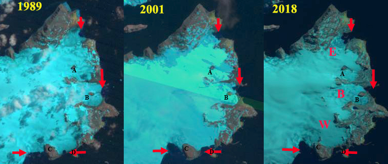
Science Alert-The Largest Iceberg in Decades Broke Free From a North American Glacier – And No One Noticed

Seattle Times-Disastrous’: Low snow, heat eat away at Northwest glaciers

Chicago Daily -Herald-Northwest glaciers melting, disappearing

Seattle Times-Ice worms’ survival secrets could help humans

Yes MagazineThreat of Salmon Extinction Turns Small Tribe Into Climate Researchers

Washington Post-The nation’s most dangerous snow pile, that even summer can’t melt

WTA-Vanishing glaciers

Mountaineers-Observable Differences: Recession of North Cascade glaciers

Wenatchee World-Lyman Glacier is slowly disappearing

Northwest Mountaineering Journal-Our Vanishing glaciers

Bellingham Herald-Scientists, Nooksack tribe study shrinking Mount Baker glacier

Wilderness Society-Goodbye to glaciers in Washington’s North Cascades?

Rockhead Science-Mauri Pelto Disappearing Glaciers

Pico Alto Glacier, Chile Retreat New Lake Formed

Pico Alto Glacier, Chile in 1986 and 2017 Landsat images indicating the retreat.  Red arrow indciates 1986 terminus, yellow arrow the 2017 terminus,and purple dots the snowline. 

Pico Alto Glacier, Chile drains north from the Argentina-Chile border entering the Rio Puelo and eventually Lago Tagua. The glacier ongoing retreat is similar to the nearby Hornopiren Glacier and Erasmo Glacier.  Davies and Glasser (2012) mapped the glaciers in the Hornopiren region and found a 15 % area loss from 1986 to 2011.

In 1986 there was no lake at the terminus of the glacier and the snowline is near the main junction.  By 2000 the glacier had retreated 1200 m opening a new lake.  The eastern arm of the glacier did not retain significant accumulation. In 2016 the snowline again left the eastern tributary without retained accumulation.  In fact the connection to the larger western tributary has been greatly reduced.  By 2017 the glacier has retreated 2.4 km with a lake of nearly the same length having formed, this is 40% of the total glacier length lost in three decades.  The eastern tributary due to a lack of retained snowpack will continue to wither away.  The main glacier can survive in a reduced state with current climate. Wilson et al (2018) noted a substantial growth in the number of lakes in the central and Patagonian Andes due to the ongoing rapid retreat. Harrison et al (2018) also observed the number of glacier lake outburst floods have declined despite the increase in lakes.

Pico Alto Glacier, Chile in 2000 and 2016 Landsat images indicating the retreat.  Red arrow indicates 1986 terminus, yellow arrow the 2017 terminus,and purple dots the snowline.

Google Earth view of the Pico Alto Glacier (PA) indicating flow, blue arrows, 1986 terminus red arrow and 2017 terminus yellow arrow

Mityushikha Ice Caps Separation, Novaya Zemlya

Mityushikha Ice Cap (M) and West Mityushikha Ice Cap (WM) arrows indicating locations of glacier  separation or glacier margin change. 

Mityushikha Ice Caps are a group of small ice caps near the southern end of the glaciated mountains of Novaya Zemlya. Here we examine two of these ice caps using Landsat imagery from 1994-2017. Much attention has focused on the retreat of the larger tidewater glaciers of Novaya Zemlya, that between 1992 and 2010 retreat rates were an order of magnitude higher for tidewater glaciers outlets (52.1 m/year than for land-terminating glaciers 4.8m/year Stokes et al (2017).  Carr et al (2017 ) observed that glacier retreat between 1973/76 and 2015 in Novaya Zemlya terminating into lakes or the ocean receded 3.5 times faster than those that terminate on land. Both studies focus on terminus retreat, here we also can observed the accumulation area ratio and area losses.

A comparison of the two ice caps Mityushikha (M) and West Mityushikha (WM), at nine locations between 1994 and 2016 indicate a consistent pattern. The most striking aspect is the lack of retained snowpack on the WM ice cap in 2016, while M ice cap has limited retained snowpack.  This pattern of snowpack loss is evident in other years and has led to the changes observed between 1994 and 2016.

  • Point 1: The northern glacier has disconnected from the ice cap.
  • Point 2: A significant expansion of bedrock leading to reduced glacier connection.
  • Point 3: The ridge has extended west toward the ice cap margin.
  • Point 4: The two outlet glaciers have separated.
  • Point 5:  The southern glacier has separated from the rest of the ice cap.
  • Point 6:  Separation of the southern glacier from the WM.
  • Point 7: Expansion of bedrock exposed areas.
  • Point 8: Expansion of bedrock area amidst ice cap.
  • Point 9: Separation of northern glacier from ice cap.

A comparison of Landsat images from 2001 and 2017 indicate retreat of outelt glaciers fro the Mityushikha Ice Cap at six locations.

  • Arrow 1: A 300 m retreat
  • Arrow 2: A 600 m retreat
  • Arrow 3: Separation from #2 and 600 m retreat.
  • Arrow 4: A 150 m retreat.
  • Arrow 5: A 500 m retreat
  • Arrow 6: A distributary terminus of #1 a 500 m retreat

The rate of retreat of these small ice cap glaciers is higher than reported by Stokes et al, (2017) or Carr et al, (2017)  What is also evident is the significant area and volume losses.  Mass losses indicate that climate change is not just affecting glaciers via increased calving losses. The changes are not as eye catching as the retreat of large outlet glaciers, leading to new island formation, Nizkiy Glacier, but is similar to that seen at Lednikovoye Glaciers.

Mityushikha Ice Cap with red arrows indicating six glacier terminus that have retreated from 2001 to 2017 in Landsat images.

North Cascade Winter Snowpack Status 2018

2018 Winter Freezing levels at Mount Baker (November 2017-March 2018). 

The accumulation season on most Northern Hemisphere glaciers extends through April. The key benchmark for snowpack water assessment in alpine ranges is typically April 1, as that is the average maximum snowpack for an alpine range.  In 2018 the North Cascade Range had freezing levels above the long term mean, but at the 21st century mean.

A result of higher freezing levels is more rain on snow events and winter melt events.  This reduces the retained April 1 snowpack, which is measured as snow water equivalent (SWE).  An examination of the trends in April 1 SWE at the six long term North Cascade stations, winter precipitation at the most reliable North Cascade weather stations, and the ratio between the two indicates a similar decline in snowpack and snowpack/winter precipitation ratio, while winter precipitation has increased.   The  ratio between SWE and precipitation, snowpack storage efficiency-on right axis, has been in decline,  as noted by Mote et al (2008) and Pelto (2008).  This ratio change has driven most of the SWE.

For 2018 precipitation is 2.7 m with, 1.1 m of that retained on average as April 1 SWE.  The April 1 SWE is similar to the 2016 and 2017 values.  

At the sites closest to the glaciers with snowpack measurements the April 1 snow depth is 4.21 m at Lyman lake and 4.24 m at Mount Baker ski area.  At Stevens Pass there is a snow depth of 3.53 m, which is approximately the average, webcam image below is from 4/6/2018. As winter wraps up, snowpack is relatively normal despite a winter of wide temperature fluctuations, Feb freezing levels 400 m below the mean and December 500 m above the mean. The glaciers still have 3-6 weeks for accumulation to build up, while melt get underway lower on the mountains.  We will be in the field again in 2018 to examine snow depths and melt across the North Cascade glaciers.

A view up toward the icefall on Easton Glacier at 2000 m.

Stevens Pass ski area from Webcam 4/6/2018

Monte Cristo Range waiting for spring to begin

Mount Baker coated with March 2018 snowpack.


Warsaw Icefield, King George Is., Antarctica Retreating from Shoreline

Warsaw Icefield, King George Island, Antarctica glacier retreat and nunatak expansion in 1989, 2001 and 2018 Landsat images. E=Ecology Glacier, B=Baranowski Glacier, W=Windy Glacier, 1989 terminus locations indicated by red arrows.  Point A & B are nunataks. 

The Arctowski Polish Research Station is located on a relatively large ice-free oasis northeast of the Warsaw Icefield on King George Island, Antarctica. The station is on Admiralty Bay where  Ecological monitoring has been conducted since the late 1970’s in order to determine the size and condition of populations of seabirds and pinnipeds. The ocean bottom has had over 800 distinct benthic species identified. A long term study of a chinstrap penguin colony on King George Islands during the last 30 years indicates the size of the breeding populations has decreased by 84% probably due to limitations of the marine food web (Korczak-Abshire et al 2012). The outlet glaciers of Warsaw Icefield experienced significant retreat and mass loss (Petlicki et al, 2017). Here we examine Landsat images from 1989 to 2017 to illustrate the changes.  The Warsaw Icefield extends from 400 m to sea level.

In 1989 Baranowski and Windy Glacier terminate on the coastline lacking any significant embayment.  Ecology Glacier has a wide front in a shallow embayment.  Nunataks A and B are amidst the icefield. In 1990 the snowline is at 200 m with nunatak A and B in the ablation zone.  In 2001 nunatak A and B are still surrounded by ice.  Windy Glacier and Baranowski Glacier have retreated with embayments forming.  The embayments are separated from ocean by a coastal strip of land.  An embayment has also opened to the west of Windy Glacier and Point C due to glacier retreat. In 2005 the snowline is at 250 m.  Baranowski glacier retreat has led to Nunatak B reaching the margin of the glacier, the embayment expanding on the north side of the margin. In 2014 Ecology Glacier has retreated opening the embayment.  In 2018 Ecology Glacier has retreated 600 m since 1989 exposing several small new islands in this protected embayment.  the Tidewater front is quite limited in 2018. Nunatak A is within 400 m of the edge of the icefield, whereas in 1989 the nunatak was 1.2 km from the margin. The 1989-2018 500 m retreat of Baranowski Glacier has led to the development of a dominantly land based terminus. Windy Glacier has retreated 400 m since 1989 and is now land terminating. The glacier to the west of Windy Glacier and Point C has opened a 0.5 square kilometers embayment. The retreat of Warsaw Icefield is similar to that of Endurance Glacier, Elephant Island.  Petlicki et al,( 2017) indicate mass balance has not been as negative from 2012-2016 which should slow retreat.  The new embayments offer potential new locations for penguins that Arctowski scientists will monitor.

Warsaw Icefield, King George Island, Antarctica glacier retreat and nunatak expansion in 1990, 2005 and 2014 Landsat images. E=Ecology Glacier, B=Baranowski Glacier, W=Windy Glacier.  Point A & B are nunataks in 1989. 

Map from the Arctowski Research Station in 2007 indicating glacier changes from 1978 mapped margins to 2007 dark line margin.  This dark line has been annotated to be visible for this post. 

Cook Ice Cap Retreat & Nunatak Expansion, Kerguelen Island

West margin of Cook Ice Cap in 2001 and 2018 Landsat images.  Red arrows indicate terminus margin in 2001 in both images. Nunataks A-D and Nunatak Lacroix (L) are also shown.

On the west side of the Cook Ice Cap on Kerguelen Island a series of outlet glaciers have retreated and several nunataks have either expanded or are no longer surrounded by ice.   The glacier include Pasteur, Pierre Curie, Larmarck and Descartes from north to south. Here we examine the changes from 2001-2018 along using Landsat imagery.  This is a very cloudy region and no other images allowed a clear view, except a Sentinel image also from 2018. Retreat of glacier in the region was examined by Berthier et al (2009) and is exemplified by the retreat of Ampere Glacier.  Verfaillie et al (2016)examined the surface mass balance using MODIS data, field data, and models.  They identified that accelerating glacier wastage on Kerguelen Island is due to reduced net accumulation and resulting rise in the transient snowline since the 1970s, when a significant warming began.

On the west side of Cook Ice Cap in 2001 there is one significant Nunatak in the midst of the ice cap Nunatak Lacroix (L). Nunatak A and D do not exist.  Nunatak C is encircled by ice and Nunatak B is nearly surrounded. Pasteur Glacier reaches tidewater across a broad front in 2001. By 2018 Nunatak D has emerged 1.2 km inland from the margin. Nunatak A has also emerged 4.0 from the ice margin. Nunatak C is now a ridge separated from the ice cap. Lacroix Nunatak is much expanded. Pasteur Glacier is narrower has retreated 600 m and does not reach tidewater, but terminates on a proglacial delta. Pierre Curie Glacier 1.2 km and is now just 2 km from the ice cap margin. Lamarck Glacier that terminated in a proglacial lake has now retreated from that lake, a retrated 1100 m.  Descartes Glacier  has retreated 1000 m with a narrow arm of the lake extending northward. A new proglacial lake has also formed down glacier of Nunatak D.  The retreat of the western margin of the Cook Ice Cap supports the mass balance losses determined by  Verfaillie et al (2016).  The east side of the Cook Ice Cap is also retreating forming a new lake district.

West margin of Cook Ice Cap in  2018 Sentinel image.  Red arrows indicate terminus margin in 2001 in both images.  Nunataks A-D and Nunatak Lacroix (L) are also shown. Retreat of outlet glaciers at the five arrows is 900 m.


Heilprin Glacier, NW Greenland Pinning Point Decline 1987-2017

Heilprin Glacier in 1987 and 2017 Landsat images.  The ice front is shown with yellow dots. Island A, Island B and Point C also are noted. Island A and B both have reduced ice contact, but remain as important pinning points. How much longer for Island A?  Retreat from 1987-2017 is 1.6 km to the south, 1.1 km in the center and 2.2 km on the northern margin.

Heilprin Glacier is an outlet glacier in northwest Greenland. Along with the neighboring Tracy Glacier it drains ~12,000 square kilometers of the ice sheet into Inglefield Bay.  Hill et al (2017)  note that neither glacier has a floating tongue and that Tracy Glacier has retreated faster. The velocity of Tracy Glacier is also higher than Heilprin Glacier, with most of the calving front exceeding 1200 m/year (Joughin et al, 2010).  Heilprin Glacier has a only a narrow section on the northern side that exceeds 1000 m/year (Joughin et al, 2010). Sakakibara and Sugiyama (2018) examined glacier velocity and frontal positions of 19 glaciers in the region including Tracy and Heilprin Glacier. They  observed that retreat began in ~2000 which coincided with a regional rise in summer mean air temperature.  The outlet glaciers also accelerated and those that did had the greatest acceleration generally retreated the most. Here we examine Landsat images from 1987-2017 illustrating terminus changes.

In 1987 The Heilprin Glacier front was 12 km long with two islands providing pinning points and separating the terminus into three calving regions.  The southernmost was south of Island A, Lille Matterhorn, which was 1.7 km wide and extended 1.6 km west from the east end of Lille Matterhorn, total ice contact was 2.4 km.  Island B was in contact with the ice on the east side from the southwest to the northwest corner, 3.5 km.  The northern segment was the longest calving front at 5.6 km ending at Point C.  By 1998 the glacier southern segment at Island A had changed little. Island B was still in contact with the ice along its east side from the southwest to northwest corner.  The northern segment had retreated from Point C by 1.4 km.  In 2009 retreat south of Island A has begun. In 2017 at Island A the glacier was barely in contact with the island with the southern most calving section having retreated 1.5 km since 1987.  Island B was still in contact with ice on the east side from the southwest corner, but no longer at the northwest corner.  retreat from the northwest corner is 1.1 km. The total contact with Island B in 2017 is 2.6 km, 70% of the 1987 contact.  At Island A the contact is 0.2 km a 90% reduction since 1987.  When Island A separates the loss of this pinning point will enhance retreat of the southern section of the ice front. The northern margin near Point C has retreated 2.2 km since 1987. Sakakibara and Sugiyama (2018)  identify a velocity change in the terminus reach of 13 m/a from 2000-2014.  They also note the retreat rate increased to 109 m/year from 2000-2014.

Heilprin Glacier in 1998 and 2009 Landsat images.  The ice front is shown with yellow dots. Island A, Island B and Point C also are noted. 

Nuna GIS map of the region indicating Island A and B and Point C. The margin here is from before 2000. 


Sermeq Kuadtleq, Greenland Retreat Island Development Nunatak Expansion.

Sermeq Kuadtleq in Landsat images from 1999, 2013 and 2017.  The red arrow is the 1999 terminus location, yellow arrow is the 2017 terminus location. Nunatak 1 and 3 are noted and the developing Island 2. 

Sermeq Kuadtleq (not only glacier in Greenland with this name) flows south to Prince Christian Sound from an icecap peripheral to, but connected to the Greenland Ice Sheet.  As such the glacier is not impacted directly by ice sheet changes.  Here we examine changes from 1999-2017. Greenland tidewater outlet glaciers in this region have experienced substantial retreat since 1990 Weidick et al (2012) and Howat and Eddy (2011). Tasermiut Fjord and Alangordlia Fjord are southern Greenland fjords that have lost their tidewater glacier connections. Kangersuneq Qingordleq is a similar example near Prince Christina Sound that is a retreating tidewater glacier that is not connected to the main GIS.

In 1999 the glacier extends to within km of the main sound, red arrow on west margin.  There are two nunataks noted Nunatak 1 is in the ablation zone and Nunatak 3 is in the accumulation zone.  In 1999 and again in 2002 the snowline is a short distance above Nunatak 1 at 600-650 m.  By 2013 the glacier has retreated expanding the fjord, and a new island at the margin, Island 2 has emerged from beneath ice and is helping stabilize the east half of the terminus.  Nunatak 1 and 3 are also more expansive. In 2013 and 2016 the snowline is at 700 m.  In 2017 the western margin of the glacier has retreated 1600 m since 1999 and eastern margin has retreated 600 m.  The connection to Island 2 is also been reduced since 2013. Once the connection is lost the east margin will retreat faster.  The glacier is still a tidewater glacier, but is within a km of what will be the head of the fjord, based on the steep surface slopes shortly above the terminus.  The glacier will lose its connection to tidewater like glaciers in Tasermiut Fjord.  Currently the retreat is relatively rapid like other tidewater glaciers near the southern edge of the GIS.  The glacier just to the east has lost connection to tidewater, pink arrow, note on map as emptying into Sermilerajik. The behavior of this glacier matches other nearby glaciers including  Kangersuneq Qingordleq and the glacier entering the Kangerdluk Fjord just to the west (This is again not the only fjord with this name).

Greenland topographic map, from Nuna GIS, of the eastern end of Prince Christina Sound.  Note blue arrow indicates Sermeq Kuatdleq and pink arrow Sermilerajik, which no longer reaches tidewater. 

Sermeq Kuatdleq in Landsat images from 2002 and 2016.  The red arrow is the 1999 terminus location, yellow arrow is the 2017 terminus location. Nunatak 1 and 3 are noted and the developing Island 2. 

Easton Glacier, Mount Baker, WA Annual Retreat & Mass Loss 1990-2017

Mass balance, terminus and supra glacial stream assessment are illustrated in the video, Filmed by Mauri Pelto, Jill Pelto, Melanie Gajewski, with music from Scott Powers.

This is the story of  the annual monitoring of Easton Glacier, Washington.  We have been monitoring Easton Glacier on Mount Baker, a stratovolcano in the North Cascade Range, Washington since 1990.  Each year we survey the terminus position, measure its mass balance, assess crevasse depths and map surface elevation on a transect across the glacier.  In 1990 Easton Glacier was in contact with an advance moraine built from the late 1950’s- 1980’s.  The advance moraine is noted in the 2015  Washington DNR Lidar  image of the terminus area by black arrows. The green arrows indicate the recessional moraine from the winter of 2015. Red arrows indicate the Little Ice Age lateral moraines Railroad Grade (RG) to the west and Metcalfe Moraine (MM) to the east. From 1990-2017 the glacier has retreated 370 m, including 65 m in the last three years. The second Lidar image indicates the transect where the surface elevation is mapped, red line.  This is close to 2000 m in elevation, and in a good snow year retains snowpack and in most recent years has lost its snowpack (note paired image below). In 2015 the worst year, the snowpack had been lost by the end of July. Note the comparison of the 2017 transect snowpack and 2015 lack of snowpack.

Washington DNR Lidar image of Easton Glacier , black arrows indicate 1980’s advance moraine, green arrows 2015 winter moraine and red arrows the Little Ice Age lateral moraines. Blue dots indicate the glacier margin.


Washington DNR Lidar image of Easton Glacier. Blue dots indicate the glacier margin.  Red line the cross glacier profile.

A view along the cross glacier profile at 2000 m in early August of 2015, snowpack gone already and in 2017 with 2 m of snowpack remaining. 

More than 5000 measurements of snow depth and melt have been completed illustrating the glacier has lost 16.6 m of water equivalent thickness, over 18 m of thickness from 1990-2016.  For a glacier that averaged 70 m in thickness in 1990 this is ~25% of the volume of the glacier gone.  The glacier has not maintained sufficient snow cover at the end of the summer to have a positive mass balance, this is the accumulation area ratio.  The mass balance and terminus data is reported annually to the World Glacier Monitoring Service.  The area lost in the terminus region due to the retreat has been 0.22 km2.

The glacier has also slowed its movement as it has thinned, evidenced by a reduction in number of crevasses. In the lowest icefall Jill Pelto has surveyed the crevasse depths finding a mean depth 20 m and a maximum depth of 32 m. This glacier supplies runoff to Baker Lake and its associated hydropower projects.  Our annual measurements here and on Rainbow Glacier and Lower Curtis Glacier in the same watershed provide a direct assessment of the contribution of glaciers to Baker Lake.  The glacier is also adjacent to Deming Glacier, which supplies water to Bellingham, WA. The Deming is too difficult to access, and we use the Easton Glacier to understand timing and magnitude of glacier runoff from Deming Glacier.  Deming Glacier has retreated a greater distance during this period, 705 m, but has lost a similar area.

Annual terminus survey in 2015 terminus exposed to melting by early July.  In 2017 terminus being exposed first week in August. Taken from same location.

Crevasses measurement in lower icefall and on the cross profile.  In both cases crevasse depth is measured, on the profile 2017 winter snow depth remaining measured. 

Easton Terminus viewed from our benchmark location just beyond 1980’s margin. Tree in foreground is over 50 years old.