The snow line (yellow dots) on Mount Everest region glaciers on Feb. 11, 2024 in this Landsat image average 6040 m. This is a 200 m rise from October 22, 2023 and a 20 m rise since Jan. 10, 2024. The passes at Nangpa La and Nup La are both snow free.
The snow line (yellow dots) on Mount Everest region glaciers on Jan. 10, 2024 in this Landsat image average 6020 m. This is a 200 m rise from October 22, 2023. The passes at Nangpa La and Nup La are both snow free. The rise has occurred during a prolonged dry period, temperatures have been cold as is typical.
Mount Everest glaciers are summer accumulation-type glaciers with ~75% of annual precipitation occurring during the summer monsoon (JJAS). The summer monsoon period also has the highest melt rates at lower elevations on the glaciers. October has been considered the end of the melt season in the region, with limited precipitation in the post-monsoon and early winter season (October–December). Winters (DJF) are cold and dry, though they do have the most variable precipitation.
A rising snow line elevation on glaciers in the region from October to February indicates significant ablation occurring during the first half of the winter season on glaciers in the Mount Everest region. The series of weather stations on Mount Everest installed by the National Geographic Expedition-Perpetual Planet in 2019 and with repeated updates and maintenance since provides the ability to put the snow line change in context of the local conditions for the first time. higher snow line at the end of summer monsoon season in 2020 and 2023, combined with warmer post-monsoon, and dry winter conditions, can drive a snow line to rise from October into the winter on Himalayan glaciers, thus extending the melt season (Pelto et al 2022). An examination of winter weather conditions from stations on Mount Everest documented that substantial sublimation rates with losses up to 2.5mm/day occur (Tenzing Chogyal Sherpa et al 2023).
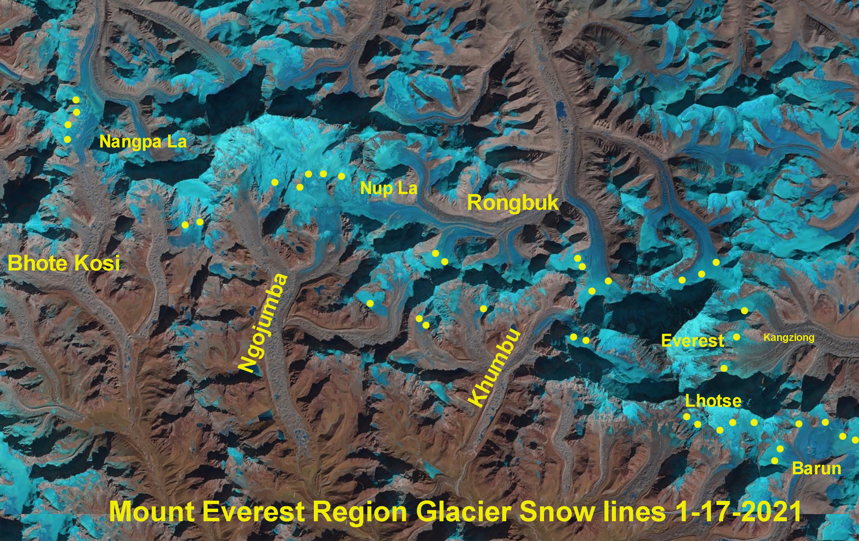
The snow line (yellow dots) on Mount Everest region glaciers on Jan. 17, 2021 in this Landsat image average 6150 m. This was a 250 m rise from Oct. 13, 2020. The passes at Nangpa La and Nup La are both snow free. The rise has occurred largely during a period of record winter warmth extending from Dec. to Jan.
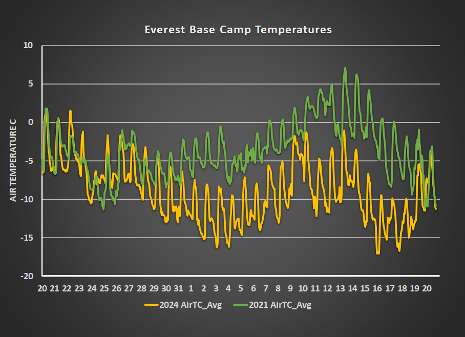
On Oct. 22, 2023 a Landsat image allowed identification of the snow line on Everest region glaciers, which averaged 5800 m. From Nov. 1-2023 to Jan 20, 2024 there has been less than 25 mm of precipitation at Everest Base Camp (5315 m), this persistent dry period had one period of warm weather from Dec 14-Dec. 22, with six days exceeding 0 °C. From Dec 23-Jan 20 winter, temperatures have remained below 0 °C. Daily images from. The EBC weather station have yielded a nearly continuous series of clear sky days. The result has been sustained sublimation that is important for snow loss, despite the low temperatures solar radiation does generate ablation even when temperatures do not exceed 0 °C for ice, and snow in regions with significant debris material (Matthews et al 2020). The result the average glacier snow line has risen above 6000 m by January 10, 2024 and has remained above this level into Februrary 2024.
During the 2020/2021 winter the snow line rose an average of over 200 m from 13 October 2020 to 17 January 2021, with freezing levels indicating ablation to ~6000 m (Pelto et al 2022). This snow line rise was driven by a combination of dryness and warm temperatures, with ERA5 reanalysis temperature reconstructions for Everest Base Camp (5315 m) for the 1950–February 2021 period indicating that six days in the January 10–15 period in 2021 fell in the top 1% of all winter days since 1950, with January 13, January 14, and January 12, being the first, second, and third warmest winter days. Note in the graph below that temperatures rose above 0 °C on 11 consecutive days. The temperature also exceeded 0 °C on seven days in December.
In 2020/21 the conditions remained warm and dry into mid-January (Pelto et al 2022), while in 2023/24 the conditions have been cooler and dry. In both cases the rising snowline is the result of sublimation. Relative humidity measured at the has averaged less than 20% at the EBC in January 2024 (National Geographic-Perpetual Planet), this increases the potential for sublimation and reduces potential for melting..
Elevation of the snow line on Everest region glaciers determined from Landsat images of 10/13/2020, 1/17/2021, 10/22/2023 and 1/10/2024.
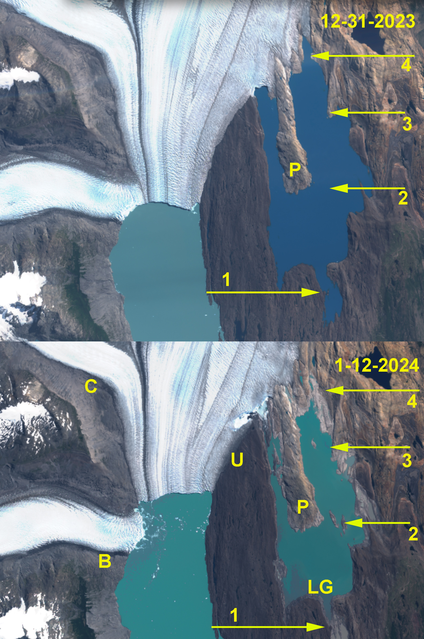
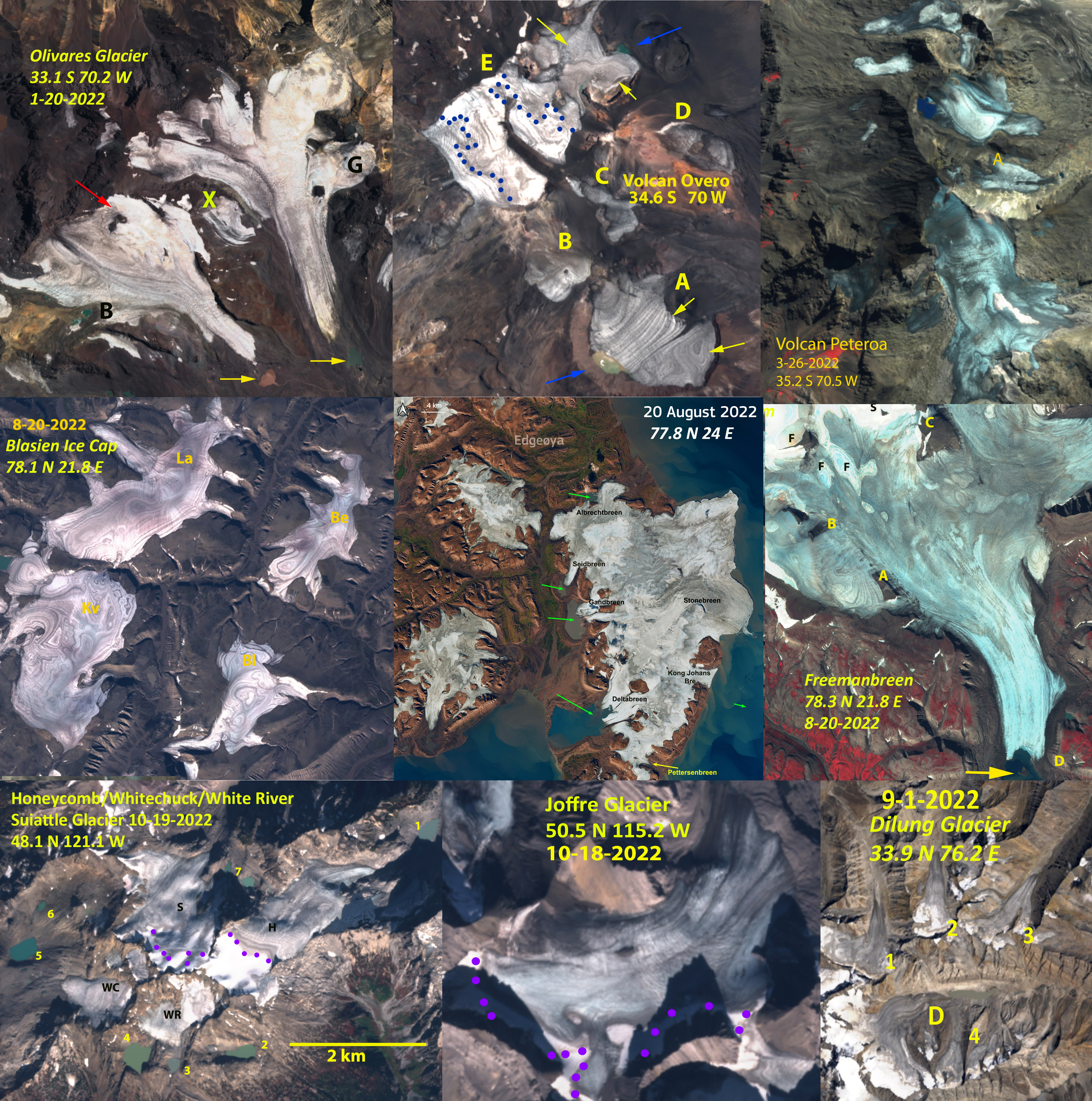
View of Lago Guillermo in true color Sentinel 2 images from Dec. 31 2023 and Jan 12 2024. Illustrating drainage of Lagor Guillermo (LG). Revealing more of the Peninsula (P). Upsala Glacier (U) had impounded this lake since formation by 1957.
Lago Guillermo draining during early January 2024 as revealed by Landsat images. Notice inlet left dry at Arrow 1, Arrow 3 ad Arrow 4. New islands at Arrow 2.
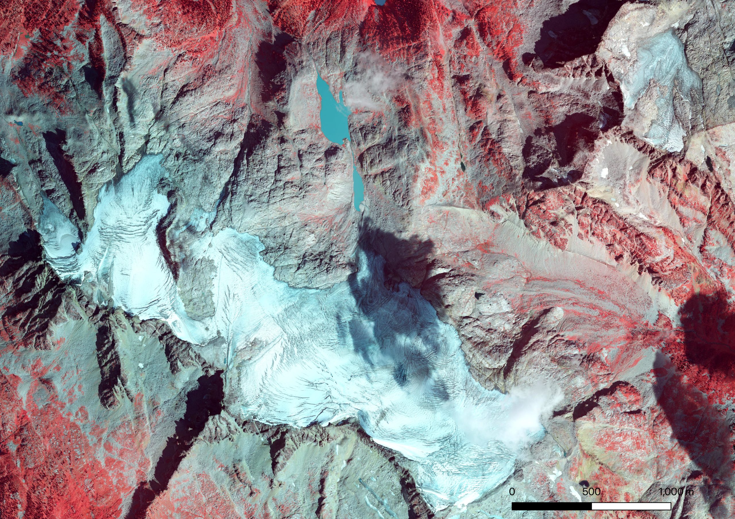
Lago Guillermo developed by 1957 as Upsala Glacier, Southern Patagonia Icefield retreated (Warren et al 1995). By 1999 a peninsula was evident extending south into the lake from the glacier terminus, see Landsat images below. By 2016 this peninsula was km long. Due to retreat and thinning of Upsala Glacier leading to detachment of Bertacchi Glacier in 2021/22 (Pelto, 2022), the ice dam impounding this lake has bee reduced. . Malz et al (2018) indicated a 3.3 m thinning of Upsala glacier with significant thinning extending to the Viedma Glacier divide. On Dec. 31-2023 the lake looks essentially as it has since 2016. By Jan 12. 2024 the lake had drained significantly leaving the ice margin for the first time in over seventy five year not terminating in the lake (arrow 4). The eastern terminus is now on land. The lake drainage exposed several islands within the lake (Arrow 2-Arrow 3). Led to drainage of the southern inlet at Arrow 1. Between 12-31-2023 and 1-15-2024 Lago Guillermo declined from 16 km2 to 10 km2 in area.
Recent retreat has exposed some interesting fossils around Lago Guillermo!
Upsala Glacier (U) in Landsat images from 1999, 2016 and 2023 illustrating both retreat and the separation from Bertacchi Glacier (B). Cono Glacier (C) is the next tributary to the north, to the east the Peninsula (P) in Lago Guillermo has grown as the lake has expanded.
The summer of 2023 was our 40th field season observing the response of North Cascade glaciers to climate change. Each year we visit a series of glaciers on the same date to complete our annual examination. We carry all of the equipment to each field site in backpacks and camp in tents near the glacier. All the glaciers we observe, except Easton Glacier, are in Wilderness Areas. This precludes the use of mechanized equipment or leaving instruments behind. We work each day in almost any weather conditions, and in the last decade that means dealing with forest fire smoke, only a few days have forced us to remain in our tents. We have covered over 5,000 miles, completed over 40,000 measurements and spent 800 nights in tents during the course of this research project. Three of the glaciers we observe are World Glacier Monitoring Service reference glaciers (42 in the world).
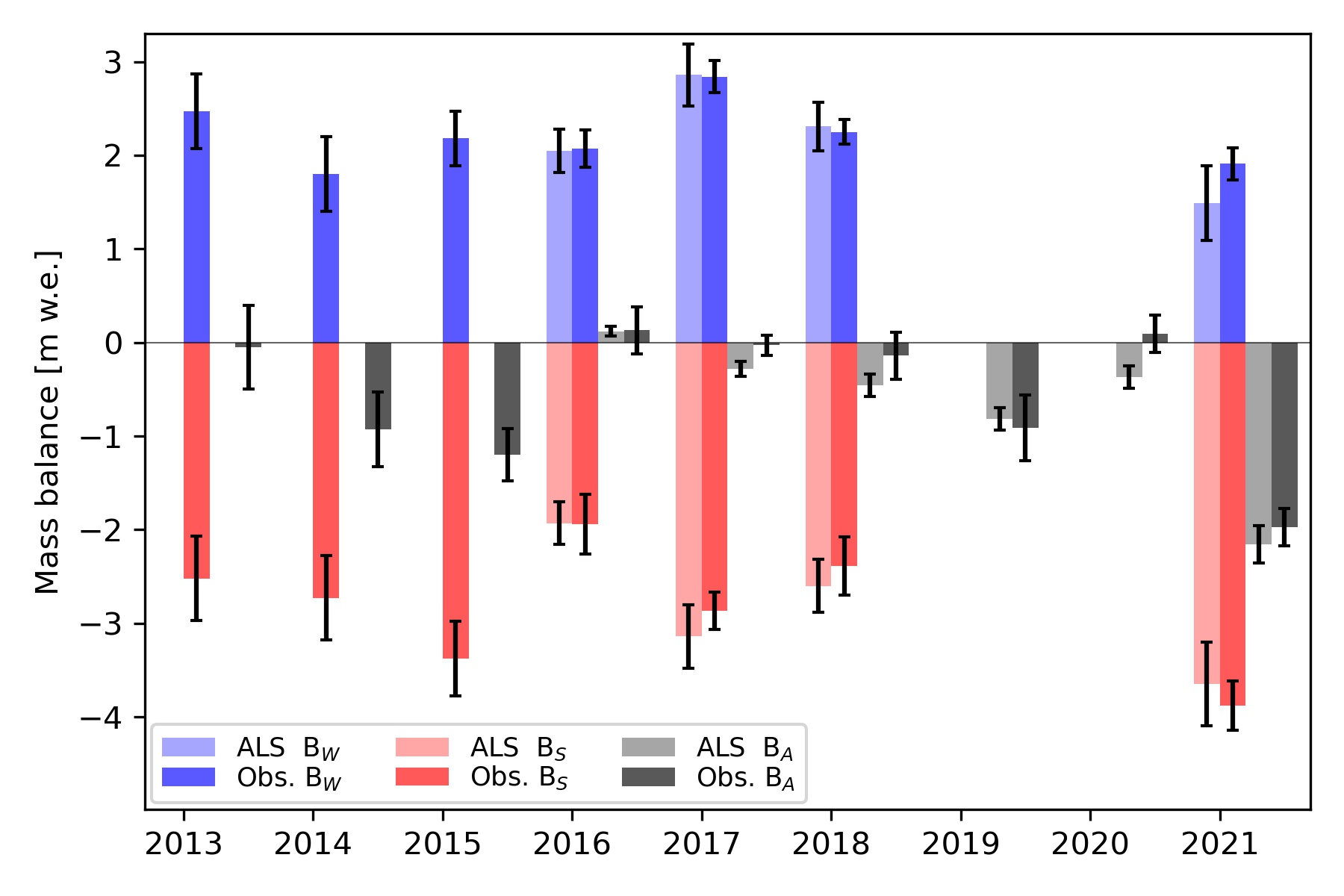
The field team consisted of Jill Pelto (Art Director), Mauri Pelto (Science Director), Julia Ditto (Field Artist), Mariama Dryak (Field Scientist-Team Logistics), Kai Yuan Wang (Field Scientist) Muruganandham Shivaprakesh (Field Scientist). For the third straight year conditions were poor for the glaciers. The 2021-2023 period was the worst three year stretch during the last 40 years with glaciers losing ~5-6 m of thickness, which is 10-20% of glacier volume depending on the glacier.
“40 Years in the North Cascades” by Jill Pelto. This painting is an emotional piece for me. It is an updated version of the very first data-art painting I created when I came up with the idea in 2015. The top surface of the mountain glacier is a line graph that depicts the mass balance of North Cascade glaciers in Washington state from 1984-2022.
We have observed the loss of three of our key glaciers we monitor, every glacier in the range has experienced significant retreat, and volume loss. Our mass balance observations indicate an average loss of 27 m water equivalent, ~30 m in thickness and ~35-40% of the entire volume of the glaciers in the mountain range lost. The summer of 2023 had the largest loss of glacier area of any of our 40 years, average terminus retreat exceeded 25 m. Ice Worm Glacier ceased to be an active glacier, joining a rapidly growing list of glaciers that are no more. The glaciers on Mount Daniel/Hinman in particular collapsed. The main variable we measure to determine glacier health is mass balance, the difference in snowfall gain vs. melt each year. The result of three bad years in a row 2021-2023, with losses exceeding -1.5 m led to this rapid retreat. The extent of blue ice was the highest we have observed on both Mount Daniel (95%) and Mount Baker (70%). This made traversing the glaciers more challenging. The added newly deglaciated unstable terrain also added challenge in accessing the glaciers.
Sholes Glacier is on a ridge extending northeast from Mount Baker and is at the headwaters of the North Fork Nooksack River. With the Nooksack Tribe we measured glacier runoff below this glacier from 2012-2021. The glacier mass balance is 24.5 m, with 2023 comprising 10% of that. The glacier has lost 10 m of thickness in the last 5 years, driving a rapid increase in retreat rate and opening a large ice cave near terminus.
Columbia Glacier is a cirque glacier at the headwaters of the North Fork Skykomish River. It is fed by avalanches mainly from the west side (left in images). The glacier retreat has accelerated in the last decade exposing a growing new lake. By 2023 the glacier has lost 40% of its volume since 1984. This is a World Glacier Monitoring Service reference glacier, one of 42 in the world. The slopes above the glacier have lost considerable perennial snowpack leaving much deeper depressions/basins that must be filled in the winter before avalanching commences. This has reduced the input of avalanches for the glacier.
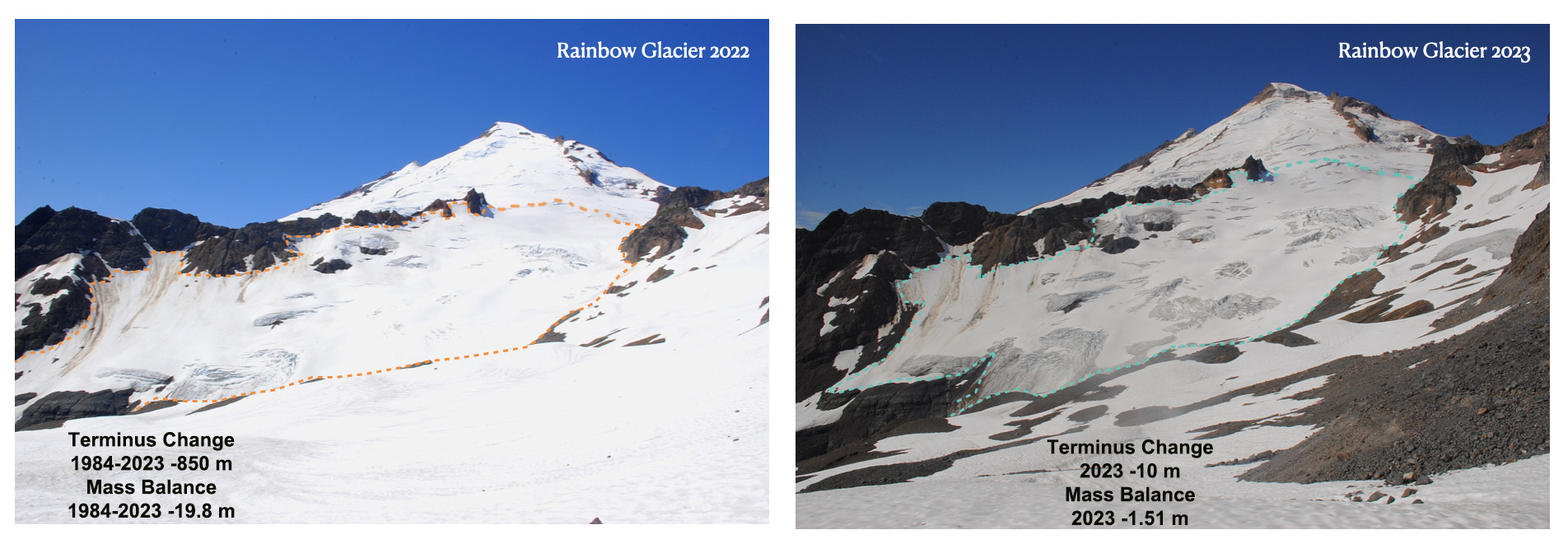
Rainbow Glacier is on the northeast side of Mount Baker and is a valley glacier that feeds Baker Lake. The glaciers starts at 2100 m at a junction with the Park and Mazama Glacier. This is a WGMS reference glacier. The glacier mass balance loss has been 19.8 m, the slowest rate of any of the glaciers. The terminus has retreated 850 m.
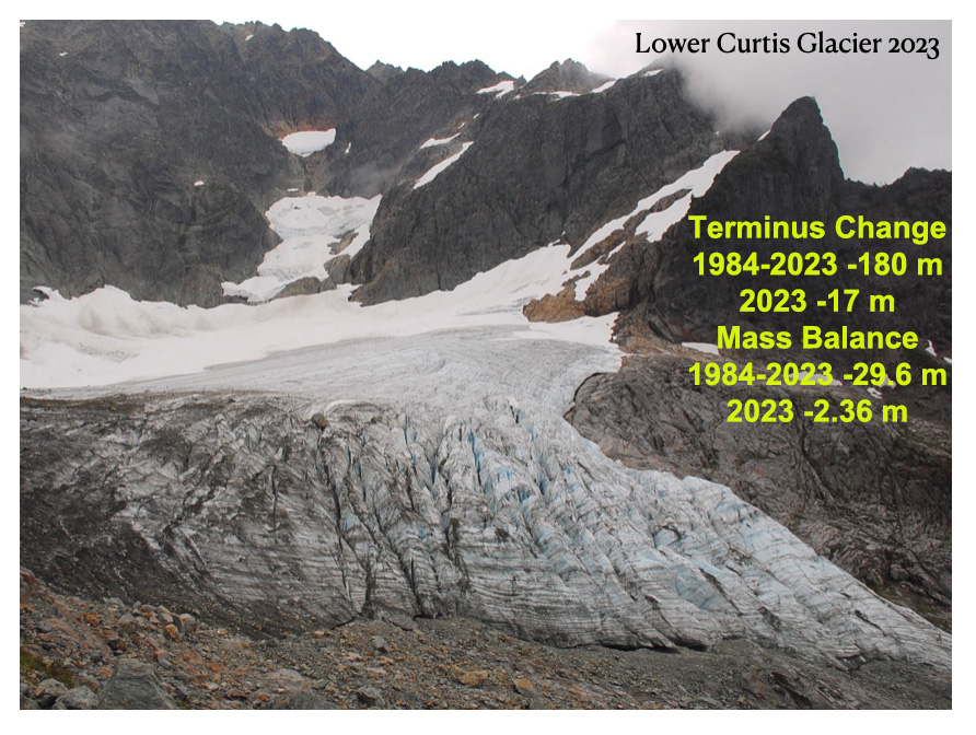
Lower Curtis Glacier is a cirque glacier on Mount Shuksan. The glacier is avalanche fed and feeds Creek and then Baker Lake. The glacier has a steep seraced thick terminus front that reduces retreat rate, though this icefall has thinned rapidly in the last 5 years. Retreat has been 180 m since 1984, but will continue to increase due to the rapid thinning. Mass balance loss of 29.9 m is leading to significant marginal recession too.
Easton Glacier is a slope glacier on the south side of Mount Baker. The glacier feeds into Sulphur and Rock Creek and then the Baker River system. Sulphur Creek is diverted into Baker Lake. This is a WGMS reference glacier and has a mass balance loss of 24 m since 1990. The retreat of this glacier from the 1955-1980 period of advance was minor until 1992. Since then the retreat has been 570 m, including 100 m in the last two years.
Field team standing at the 2022 terminus location of Easton Glacier looking at one year of retreat on August 11, 2023.
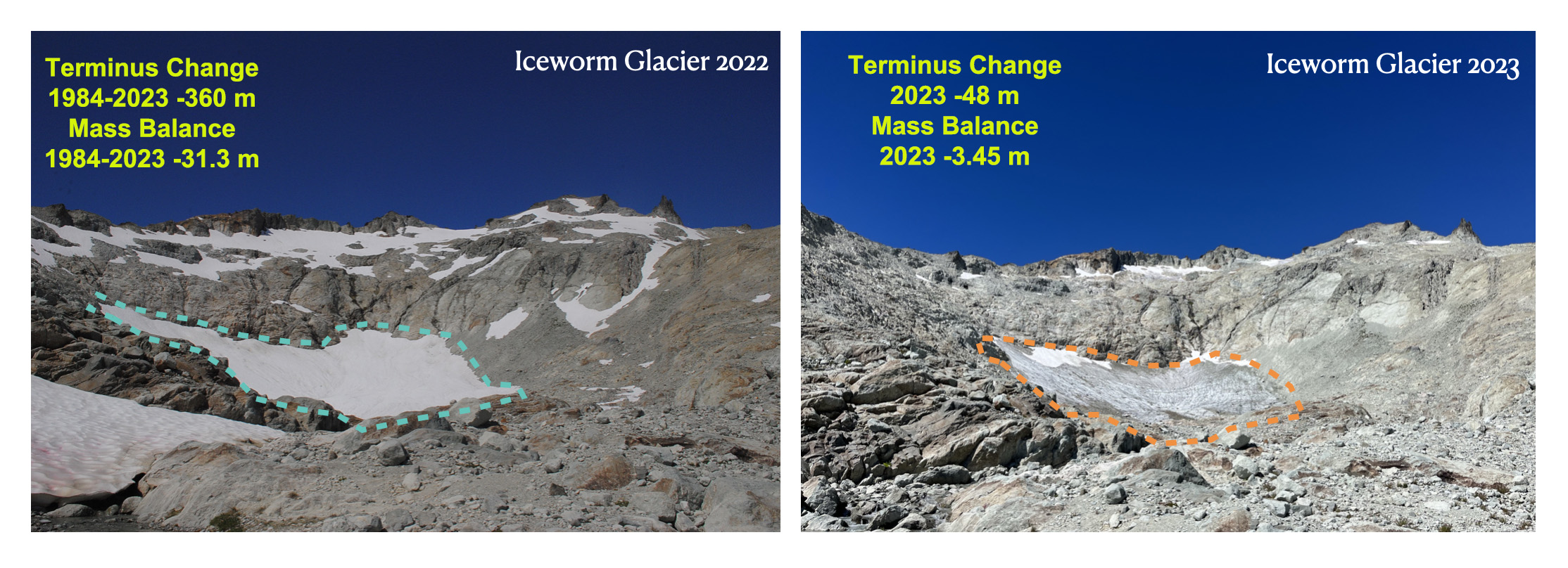
Ice Worm Glacier is a small cirque glacier on the east side Mount Daniel feeding the Cle Elum River. The glacier has been retreating rapidly both at the terminus and at its head. The rapid area thinning and retreat from 2021-2023 resulted in many stream channels in the glacier reaching bedrock. The glacier mass balance has been -31.3 m since 1984, which is about 80% of its initial volume. Depth to bedrock is typically 4-6 m. The area of this glacier has dropped to 40,000 m² and it is no longer moving. Hence, this is now just relict ice, not an active glacier.
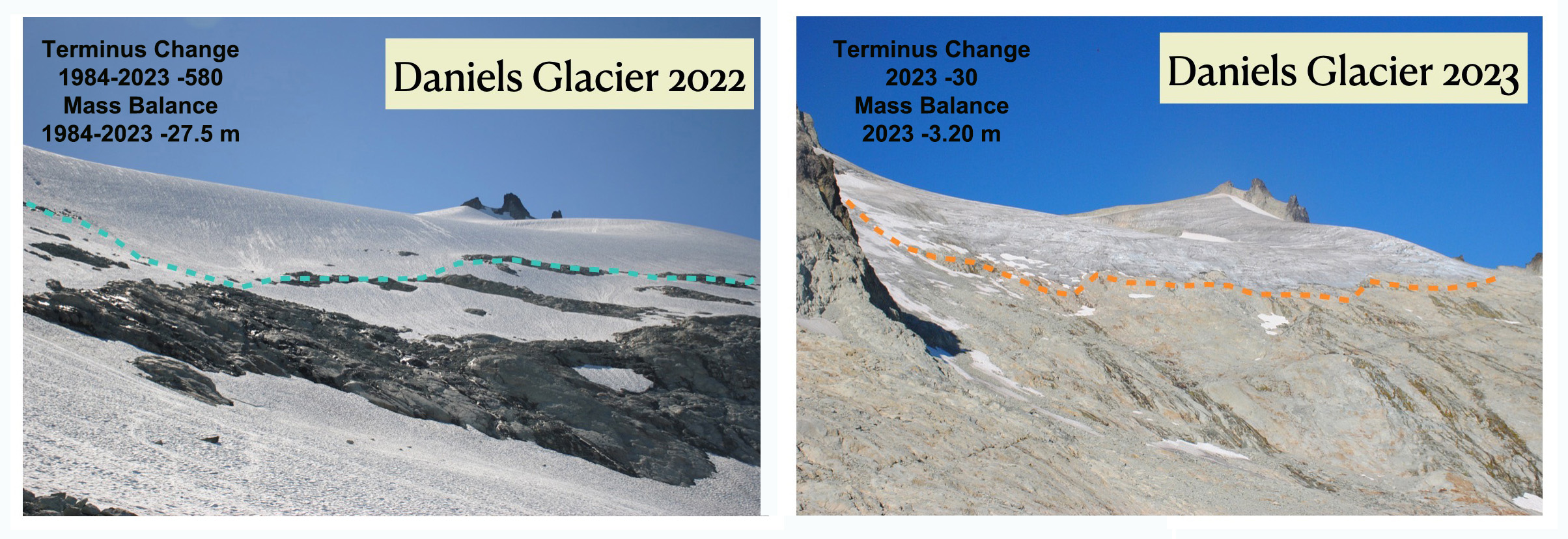
Daniels Glacier is a small slope glacier on the east side Mount Daniel feeding the Cle Elum River. The glacier dominated the east side of Mount Daniel in 1984, but now only 30% remains. Rapid mass loss of 27.5 since 1984 is leading to continued rapid disintegration of this now thin glacier. We observed many crevasses reaching bedrock even well above the terminus in 2023.
Lynch Glacier is on the northwest side of Mount Daniel at the headwaters of the South Fork Skykomish River. In 1984 the lake below was pea soup colored and filled with icebergs. Now it is a deep azure blue. The glacier has lost 25.4 m leading to rapid disintegration of the western side of the glacier. The steep thick terminus ending in the lake has retreated more slowly than other glaciers, but the volume loss has been similar.
In our camp on the North side of Mount Baker after a day on Rainbow Glacier, looking for mountain goats.
For the 14th year I had the opportunity to author the Alpine Glacier section of the State of the Climate 2022 report published in the Bulletin of the American Meteorolocial Society. Below is this report with additional images.
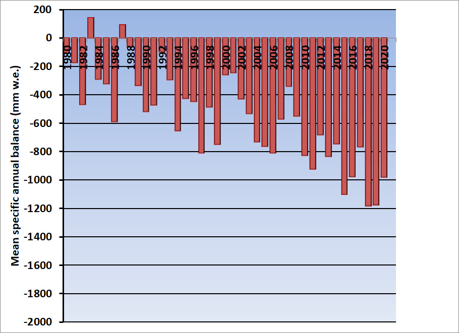
An increasing frequency of heat waves impacting glaciated mountain ranges continues to lead to large mass balance losses. In 2022 heat events in the European Alps, Svalbard, High Mountain Asia and the Central Andes of Argentina and Chile resulted in a mean annual mass balance of -1433 mm w.e., for all 108 reporting alpine glaciers, with data reported from 20 nations on five continents. In the hydrological year 2021/22 the preliminary regionally averaged annual mass balance based on the World Glacier Monitoring Service (WGMS, 2021) reference glaciers was -1179 mm w.e. compared to the 1970-2020 average -490 mm w.e.
In 2022, a negative annual mass balance was reported from 34 of the 37 reference glaciers reported to WGMS. The mean annual mass balance of thereference glaciers reporting was -1547 mm w.e.. Reference glaciers each years of observation are used to generate regional averages. Global values are calculated using a single value (averaged) for each of 19 mountain regions in order to avoid a bias to well observed regions. The regionally averaged annual mass balance was -1179 mm w.e., less negative than the general mean. This makes 2022 the 35th consecutive year with a global alpine mass balance loss, and the 14th consecutive year with a mean global mass balance below -500 mm w.e. This acceleration in mass loss from global alpine glaciers in the 21st century matches the findings of Huggenet et al (2021).
The lack of retained snowpack is evident at glaciers around the world in 2022.
More frequent and intense heat waves impacting glaciated ranges continued to take a toll on alpine glaciers in 2022. Heat waves reduce snow cover extent earlier in the melt season, exposing ice surfaces earlier and enhancing surface darkening, both causing higher melt rates on alpine glaciers (Shaw et al. 2021; Pelto et al. 2022; Cremona et al., 2023).
All 32 reporting glaciers in the Alps, Pyrenees and Caucasus Mountains had a negative mass balance averaging –3100 mm w.e. in 2022. In the European Alps the combination of low winter snowpack and several summer heat waves generated unprecedented mass loss (BAMS, 2023?). In Switzerland the 25 days of heat waves in 2022 are estimated to have melted 1.27±0.10 km3 w.e., equivalent to 35 % of the overall glacier mass loss during the summer (Cremona et al, 2023).
In Norway and Sweden, the average balance of 11 reporting glaciers was -443 mm w.e., with three glaciers in Norway having a positive balance. Iceland completed surveys of nine glaciers, five had a positive balance and four a negative balance with a mean mass balance of -7 mm w.e., e.g. equilibrium.
Langjokulen (La), Kvitisen (Kv), Bergfonna (Be) and Blaisen (Bl) ice caps on Edgeøya in Sentinel image from 8-20-2022 illustrating the lack of snowcover, limited firn areas and numerous annual layers.
On Svalbard the mean loss of the four reporting glaciers was -1102 mm w.e.. The negative mass balances were due to several summer heat events (BAMS, 2023?), which led to many glaciers and ice caps losing all or most of their snow cover, further accelerating mass loss (Figure 2.c.3.1).
Screenshot
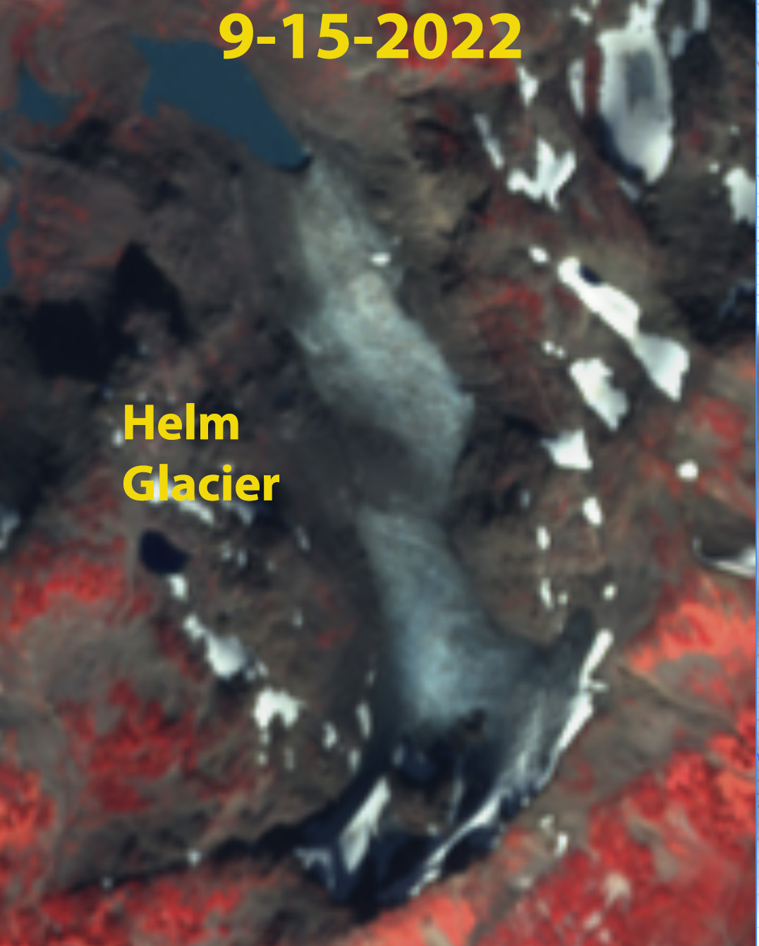
Helm Glacier BC with limited retained snowpack.
In Alberta and British Columbia, Canada and in Alaska and Washington, United States,19 glaciers had a negative mass balance, averaging -965 mm w.e.. The Alberta, British Columbia and Washington region again experienced several prolonged heat waves. Daily glacier ablation in this region was noted as increasing by 30-40% during heat wave periods (Pelto et al 2022).
Screenshot
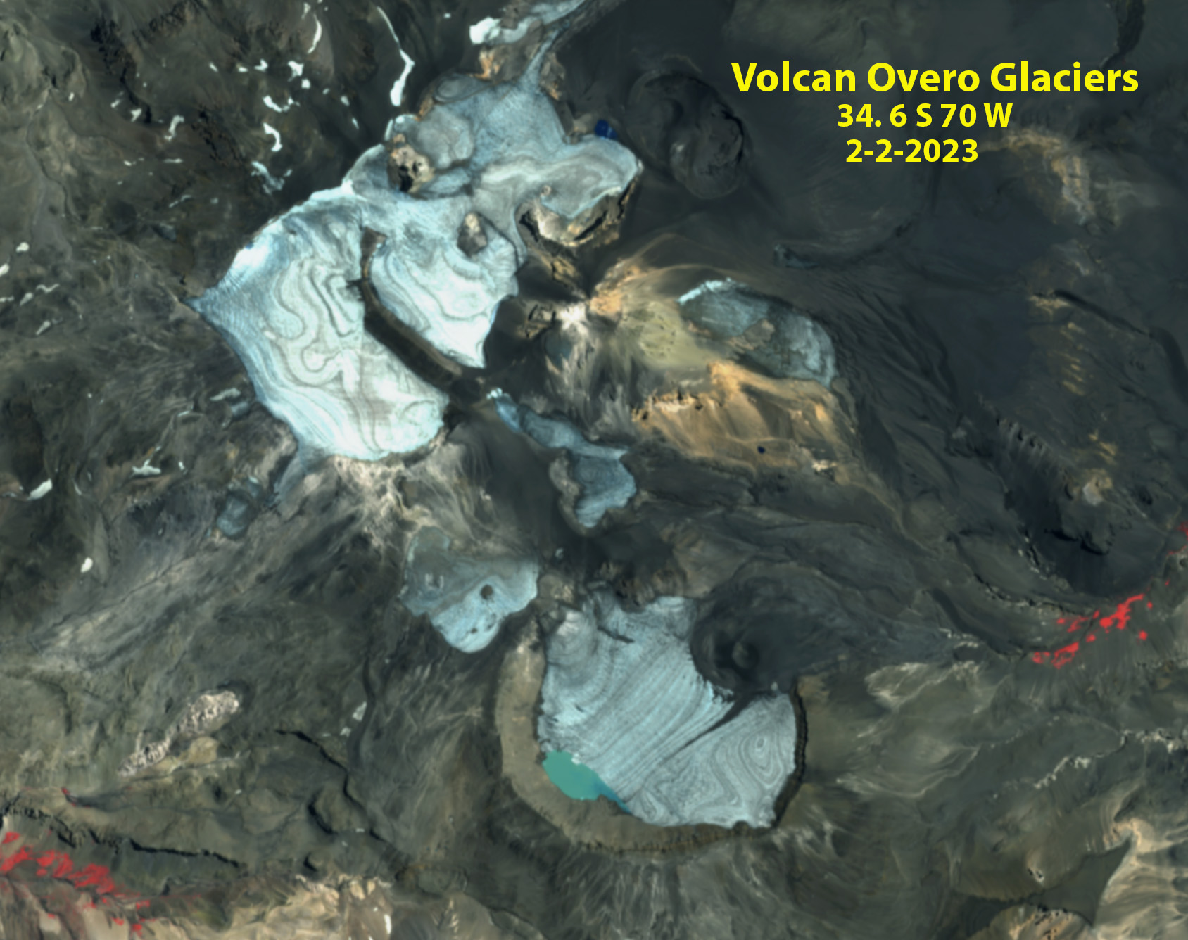
Volcan Overo, Argentina with no retained snowpack
In South America, mass balance data, reported from five Andean glaciers in Ecuador, Argentina, and Chile, were negative with a mean of -1465 mm w.e.. The combination of drought and heat events left many central Andean glaciers snow free by mid-summer in 2022. Shaw et al. (2021) noted a significant decline in surface albedo (Section 2.h.1) due to decrease fractional snow cover that further enhances melt.
In the High Mountain Asia mass balance measurements were completed on glaciers in China, Kazakhstan, Kyrgyzstan, Russia, and Tajikistan. All twenty glaciers reported negative balances. The average mass balance was -1040 mm w.e.. The negative balances were driven by above average melting during the May-July period (BAMS, 2023?).
In New Zealand the mass balance assessed on Brewster and Rolleston Glacier was strongly negative at -1125 and -1065 mm w.e. respectively. This matched the end of year snowline observations on 50 glaciers that was one of the five highest of the last 45 years.
Annual mass balance is reported in mm water equivalent (w.e.). A value of -1000 m w.e. per year is representing a mass loss of 1,000 kg m-2 of ice, or an annual glacier-wide thickness loss of about 1100 mm yr-1
The 32nd annual State of the Climate report was published today. For the 14th year I have written the Alpine Glacier section chronicling their response for the the hydrological 2020/21 utilizing the World Glacier Monitoring Service (WGMS) data sets. WGMS reference glaciers (30+ years of continuous observation) experienced a mass balance loss of -900 mm w.e., compared to -700 mm w.e. in 2019/20. From 1970-2021 the eight most negative mass balance years were recorded after 2010.
Figure 1. illustrates glacier mass balance for the WGMS global reference glaciers with more than 30 continued observation years for the time-period 1970-2020. Global values are calculated using a single value (averaged) for each of 19 mountain regions in order to avoid a bias to well observed regions.
In 2021, a negative annual mass balance was reported from 31 of the 32 reference glaciers reported to the World Glacier Monitoring Service (WGMS). The mean annual mass balance of the 32 reference glaciers reporting is -900 mm w.e., this includes data from 12 nations on four continents. This value is not the final regionally averaged global value. This will make 2021 the 34th consecutive year with a global alpine mass balance loss, and the 13th consecutive year with a mean global mass balance below -500 mm w.e..
The rate of thinning increased from –527 mma−1 for 2000-2009 to – 896 mma−1 for 2010-2019 (WGMS, 2021). This agrees well with the satellite survey of 200,000 alpine glacier by Hugonnet et al (2021) who identified a thinning rate excluding ice sheet peripheral glaciers of 360 ± 210 mma−1 in 2000 to 690 ± 150 mma-1 in 2019. Alpine glaciers lost a mass of 267 ± 16 Gta-1 from 2000-2019, equivalent to 21 ± 3 per cent of the observed global sea-level rise (Hugonnet et al, 2021). More frequent and intense heat waves continue to take a toll on alpine glaciers.
All 17 reporting glaciers in the Alps had a negative mass balance averaging – 682 mm in 2021. In Austria in 2020, of the 92 glaciers with annual terminus observations 85 (93.4%) withdrew and seven remained stationary (Lieb and Kellerer-Pirklbauer, 2021). This retreat trend will continue in 2021, with another year of mass balance loss.
In Norway the six reporting glaciers all had a negative mass balance yielding an average mass balance of -671 mm in 2021. On Svalbard the mean loss of the four reporting glaciers was -227 mm. Iceland completed surveys of nine glacier, all nine had negative balances with a mean mass balance of -1160 mm.
In the Western Canada and the United States and Washington all 14 glaciers observed in 2021 had a negative mass balance averaging -1635 mm. The exceptional heat wave during late June and early July set the stage for the large glacier mass loss. In Alaska three of the four glaciers had a negative mass balance with a mean annual balance of -528 mm.
Upper portion of Easton Glacier with a month left in the melt season
In South America, 2021 mass balance data were reported from three glaciers in Argentina, two glaciers in Chile, and one in Columbia, all were negative with a mean of -861 mm. This is greater than the 2000-2018 average loss observed in the Andes of −720 ± 220 mma-1 (Dussaillant et. al., 2019).
In the High Mountain Asia fifteen of eighteen glaciers reported negative balances in 2021. The average mass balance was-468 mm. Early winter of 2021 was warm and dry across the Himalayan Region. This was capped off by record warmth in the Mount Everest region leading to the snow line on glaciers rising and snow free glaciers up to 6000 m (Pelto, et al., 2021). This illustrates that the ablation season no longer always ends when winter begins. The importance of winter conditions was further noted by Potocki et al (2022) who report on an ice core drilled on South Col Glacier on Mount Everest at 8020 m revealing a contemporary sublimation driven thinning of ~2000 mma-1.
References
Dussaillant, I., Berthier, E., Brun, F., Masiokas, M., Hugonnet, R., Favier, V., Rabatel, A., Pitte, P.and Ruiz, L.,2019: Two decades of glacier mass loss along the Andes. Nat. Geosci.12, 802–808. https://doi.org/10.1038/s41561-019-0432-5
Hugonnet, R., McNabb, R., Berthier, E. et al 2021: Accelerated global glacier mass loss in the early twenty-first century. Nature592, 726–731. https://doi.org/10.1038/s41586-021-03436-z
Lieb, G.K. and A. Kellerer-Pirklbauer 2021: Sammelbericht über die Gletschermessungen des Österreichischen Alpenvereins im Jahr 2020. Letzter Bericht: Bergauf 2/2020, Jg. 75 (145), S. 6–15, https://www.alpenverein.at/
Pelto, M.; Panday, P.; Matthews, T.; Maurer, J.; Perry, L.B., 2021: Observations of Winter Ablation on Glaciers in the Mount Everest Region in 2020–2021. Remote Sens.13, 2692. https://doi.org/10.3390/rs13142692.
Potocki, M., Mayewski, P.A., Matthews, T. et al, 2022: Mt. Everest’s highest glacier is a sentinel for accelerating ice loss. Nature Clim. Atmos. Sci.,5, 7. https://doi.org/10.1038/s41612-022-00230-0.
WGMS 2021: Global Glacier Change Bulletin No. 4 (2018-2019). Zemp, M., Nussbaumer, S. U., Gärtner-Roer, I., Bannwart, J., Paul, F., and Hoelzle, M. (eds.), ISC(WDS)/IUGG(IACS)/UNEP/UNESCO/WMO, World Glacier Monitoring Service, Zurich, Switzerland, 278 pp., doi:10.5904/wgms-fog-2021-05.
World Glacier Monitoring Service: Fluctuations of Glaciers (FoG) Database
DOI for current scientific data (Identifier): 10.5904/wgms-fog-2021-05
Bare glacier ice exposed with months left in the melt season enhances melt. Down slope ice bands and surface roughness on Sholes Glacier.
Heat waves and glaciers don’t usually go together; however, in the last several years an increasing number of heat waves have affected alpine glacier regions around the world. This is true from Arctic Canada to the Himalayas from the Andes to Alaska. Here we review a number of these heat waves from 2018-2022, that I have been involved with assessing and observing. In particular heat waves leave a greater portion of the glacier snow free, which enhances melting and mass balance losses. This is most pronounced when the heat wave occurs prior to or early in the melt season exposing bare glacier ice for the bulk of the melt season. This occurred in summer 2021 in the Pacific Northwest, in summer 2022 in the Central Andes of Chile and Peru, and during the pre-monsoon season in 2022 in the Himalaya. In the summer of 2022 heat waves impacted the glaciers of Svalbard and Europe. In the summer of 2023 the Central Andean glaciers have again been stripped of snowcover.
Lowell Glacier in Landsat images from 7/4, 7/26 and 8/11 with Sentinel images from 7/22 . The snowline is shown with purple dots. Point A-F are fixed reference locations. The snowline migrated upglacier 20 km and 300 m in elevation. A significant snow swamp is between the yellow and purple dots on 7/26, that was not present on 7/22.
The beginning of this “wave” of observations of heat wave impacts on glaciers, was on Lowell Glacier, Yukon where a large snow swamp formed in a matter of days during a Yukon/Northwest Territories Heat Wave. On July 26, the slush covered an area of more than 40 square kilometers, with the rapid development of such a large melt area on Lowell Glacier coinciding with four days where daily temperatures at nearby Haines Junction (~60 km northeast of the glacier) reached 29 degrees Celsius. The only way to generate an extensive snow swamp is to have the snow saturated with water all the way to the surface NASA’s Earth Observatory (NASA EO).
Taku Glacier transient snowline (purple dots) in Landsat images from 7/21 and 9/16/2018.
This same heat event led to the observation that the snow lines on Taku Glacier in Alaska were the highest they had been since tracking began in 1946, 200 m higher than previously observed, with the snow line rising +10 m/day during the heat wave (Pelto, 2019).
Fork Beard (F) and Nerutusoq Glacier (N) Baffin Island on June 1, 2019, June 18, 2019 Sentinel images and June 30 Landsat image. Purple dots indicate the snowline.
During June 2019 on Baffin island Pangnirtung featured four days with record temperatures for that date June 5 (15.1), June 11 (13.5) and June 12 (13.6), and June 19 (14.4). There were 14 days with a maximum temperature above 10 C. On Fork Beard Glacier and Nerutusoq Glacier this drove a snowline rise from 800 m on June 1 to 1100 m by June 18 and 1150 m on June 30. A rate of over 10 m/day for the month.
Eagle Island Ice Cap, Antarctica in Landsat images from Feb. 4, 2020 and Feb. 13, 2020. Point E indicates an are area of snow/firn that is saturated with
An all-time temperature record for Antarctica in February 2020, a high-pressure ridge and a blocking high in the Drake Passage caused anticyclonic circulation bringing warm moist air from the Pacific Ocean to the Antarctic Peninsula Xu et al (2021). This led to vertical air flows in a foehn warming event dominated by sensible heat and radiation made generating abrupt warming Xu et al (2021). The visible impact of this heat event were the rapid rapid formation of melt ponds on Eagle Island Ice Cap I reported to NASA EO. On Eagle Island Ice Cap melt averaged 22 mm/day from Feb. 6-11 based on MAR climate model output forced by the Global Forecast System (GFS) generated by Xavier Fettweis. Rapid melting generating significant snowline rise on Coley Galcier, James Ross Island as well (Pelto, 2020).
Nanpa La (NPL) and Nup La (NL) in October 13, 2020 and January 17, 2021 Landsat imagery indicating the snow line rise that has persisted into mid- winter. Snow line indicated by yellow dots.
When record warmth spread over the Mount Everest region in January 2021, the snow lines near Mount Everest rose durng the October-December 2020 period, and remained at nearly 6,000 meters, including the key glacier passes from Nepal into China being snow free into late January. The National Geographic Perpetual Planet Expedition weather team, led by L. Baker Perry and Tom Matthew, had installed weathers stations at high elevations on Mount Everest in 2019 (Matthews et al 2020). These stations provided field observation of how warm it was during this period, which explained the snow free glaciers in winter. Temperature observations and reconstructions of daily weather conditions, dating back to 1950, indicated that the region had experienced the five warmest winter days since 1950 during a short period in January 2021. Prajjwal Panday examined the decline of snow cover area and rise of sthe snowline on glaciers from Oct. 2020 -January 2021 finding a 15% depleation and 200 m rise respectively. Even in the highest mountain range in the world, we are seeing melt conditions during the winter. This study was first published by NASA EO within a month of the event, and then in the journal Remote Sensing.
Easton Glacier has limited snowpack with two months left in the melt season in 2021. Dots indicate the firn line.
The next warm weather event was the Pacific Northwest record heat in late June 2021, setting all-time records across the region. Thompson et al (2022). comparison of daily summer maximum temperaturesthat were 3.6 SDs from the mean.. This heat wave quickly melted away much of the winter snowpack on many glaciers. The heat wave and ensuing warmth stripped the snowcover from glaciers right to the summit on the highest mountains from Mount Shasta, California to Mount Baker, Washington by mid- August exposing the dirtier ice that lies underneath the snow and melts more rapidly than snow under the same weather conditions, to the summit of these mountains. The led to increased discharge in glacier fed streams, while non-glacier fed streams in the region had significant declines in discharge. For the Nooksack River heat waves generate a 24% increase in discharge in the glaciated North Fork and a 20% decline in the unglaciated South Fork (Pelto et al 2022). For water temperature the mean increase was 0.7 °C (±0.4 °C) in the North Fork and 2.1 °C (±1.2 °C) in the South Fork (Pelto et al 2022). The resulting volume loss during the summer season has been the highest we have observed in our 38 years of monitoring North Cascade glaciers. We observed stunted alpine plant growth, experienced days of smoky air limiting visibility and had to navigate and measure more open crevasses than usual.
Whitney Glacier on Mount Shasta in 2021 Sentinel Images.
Jackson and Blackfoot Glacier in early September Sentinel 2 false color images. Point A indicates exposed ice showing annual layers. Point B indicates exposed firn that had been retained through previous summers. The gray color of the firn indicates how dirty it is and that its albedo would enhance melting.
Mount Shasta in California fared even worse, losing all snow cover on its glaciers by September 6. The largest glacier on the mountain and in California, Whitney Glacier, began to separate. In all, the glaciers there had lost 50 percent of their area and volume this century, including ~10-15 percent this summer, and had fragmented from 6 into 17 glacier pieces (Patel, Washington Post, 2021).
The summer of 2022 in the Central Andes of Argentina and Chile glaciers experience a near total loss of snowpack in January due to early summer warmth, leading to dirty/dark glaciers. The darker surfaces of the glacier melt faster leading to more rapid area and volume loss. This includes fragmentation and rapid expansion of bedrock areas amidst the glacier. The snow free conditions lasted until the end of March, extending the impact from the January observations emphasizing that this was a regional issue this summer with snowpack lost from Bajo del Plomo Glacier, Cortaderal Glacier, Palomo Glacier,Volcan Overo Glaciers,Volcan San Jose Glaciers , Cobre Glacier and Olivares Beta and Gamma Glaciers across the Central Andes of Chile and Argentina.
Volcan San Jose glaciers in Feb. 17, 2022 Sentinel image. This highlights just how dirty the ice surface is and how limited the retained snowcover is.
Cobre Glacier, Argentina in false color Sentinel 2 images from Jnauary 13, 2022 and March 16, 2022. Note the expansion of bedrock area amidst the glacier at Point A, glacier fragmenting at Point B and Point C.
Volcan Overo in Sentinel image continues to fragment with no retained snowcover this summer, and bedrock expansion at Point A.
Sentinel images the loss of all snowcover on Sollipulli Glacier that continued from January until at least March 13 2022. Note the annual layers preserved in the glacier ice now exposed at the surface.
Langjokulen (La), Kvitisen (Kv), Bergfonna (Be) and Blaisen (Bl) ice caps on Edgeøya in Sentinel image from 8-20-2022 illustrating the lack of snowcover, limited firn areas and numerous annual layers. This pattern of annual layers due to glaciers being stripped of snow cover is becoming increasingly frequent. Note Andes last winter and Pacific Northwest summer 2021.
During the summer of 2022 Svalbard experienced an extended heat wave in August that led to loss of snowpack on a number of ice caps on Edgeoya.
Rapid snowcover loss on Rhone Glacier early in summer of 2022 in Sentinel images
The European Alps were hard hit in the summer of 2022 experiencing their most negative balances observed during the 70 years of observations.
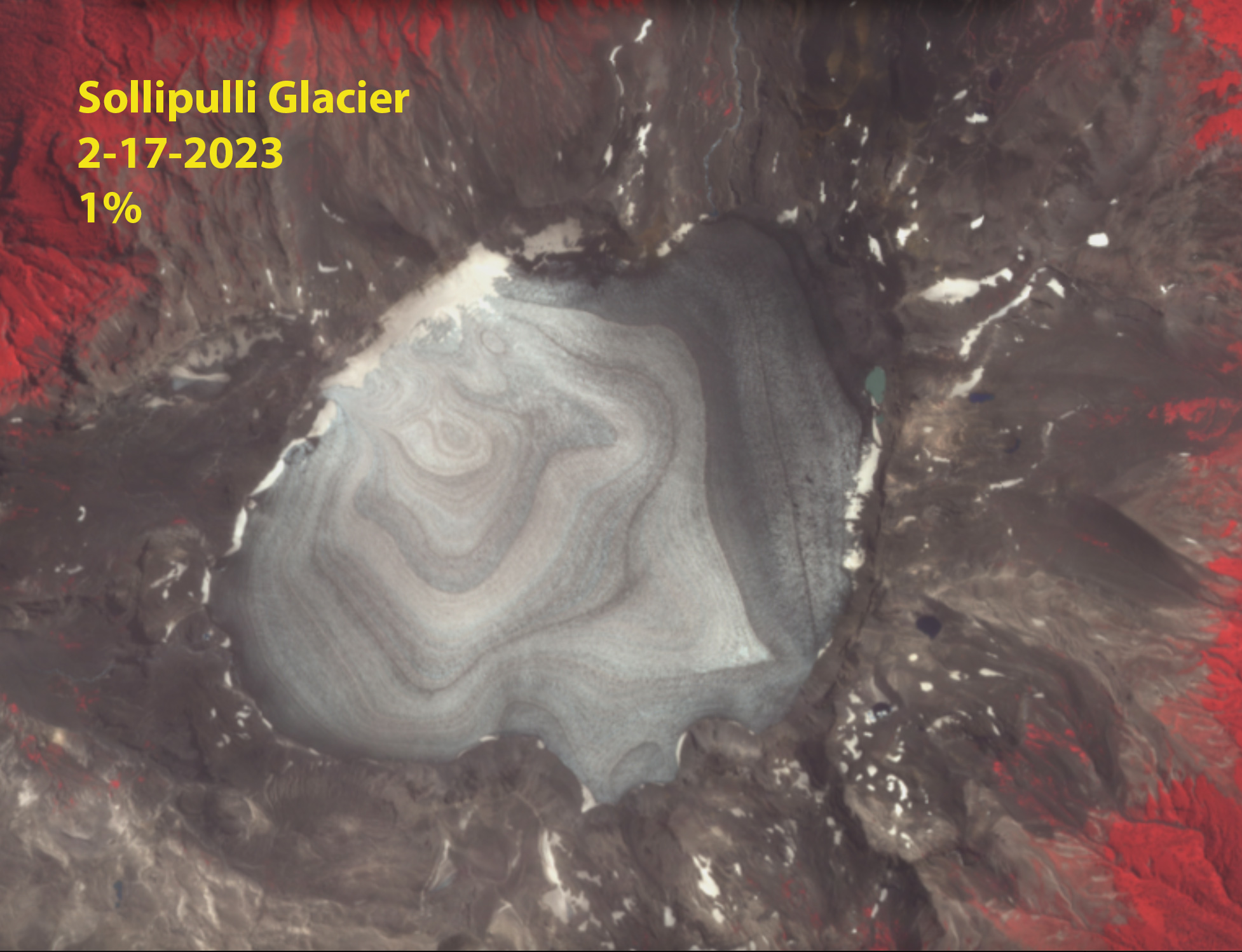
In the summer of 2023 central Andean glaciers lost snowcover during the February heat waves.
Volcan Overo, Argentina with expanding lakes, blue arrows and fragmenting at yellow arrows.
Sollipulli Glacier lost snowcover in February 2023
The bottom line is that glaciers are simply not compatible with recurring heat waves and the intensity and frequency of these is increasing. This is true from Arctic Canada to the Himalayas from the Andes to Antarctica. This year, for the 34th consecutive year, Alpine glacier volume in the world will decline; their business model is not sustainable with our climate.
1984-Landsat 5 is launched. The North Cascade Glacier Climate Project was initiated on Earth Day in 1984 with a goal of observing the impact of climate change on glaciers across this mountain range for 50 years. This was in response to a call to action by the National Academy of Sciences to have a project that monitored glaciers across an entire mountain range in the United States, and from climate scientist Stephen Schneider who challenged glaciologists at an IGS meeting in 1983 to begin the monitoring now, in order to identify the full scope of change. 50-Year Project of Glacier-article in National Geopraphic work
1985- 150,000 year climate record from Antarctic Ice Core . Snow covers the terminus of the glacier at the start of August note lateral moraines it is pressed up against.
1986-Glaciers and Ice Sheets and Sea Level: Effect of CO2 induced Climate Change-Conference Proceedings published. Thinning in 1985 and 1986 is exposing the lateral moraines, which are still ice cored.
1988-IPCC formed. The terminus remains strongly convex, with much better snowcover. The slope is impressive note the skier for scale.
1989-Mean Global CO2 levels exceed 350 ppm. Note the annual layers both paralell to the terminus and in upper right avalanche fan annual layers that are diagonal to the terminus.
1990-First IPCC Assessmenent report , Clean Air Act amended to address Ozone Depletion and Acid Rain. Heavier accumulation nearly barely the lateral moraines at the terminus, indicative of a strong avalanche season.
1991-Mount Pinatubo erupts ejecting 15 million tons of SO2 into stratosphere impacting climate. No bare ice exposed in early August for the first time since we began monitoring the glacier. A strong positive mass balane. Widespread snow in the forest below the glacier.
1992- UN Framework on Climate Change signed by 154 nations. ~50% of the glacier bare ice in early August with 90% exposed by the end of summer, resulting in large mass loss.
1993-Melt ponds observations in Landsat images on Wilkins Ice Shelf leading to breakup event published.Lower half of Columbia Glacier exposed by early August.
1994-Velocity data acquired/published for Pine Island and Thwaites Glacier. Third consecutive year of large mass balance losses, lateral moraine increasingly prominent beyond retreating terminus.
1995- Second IPCC report- Another year of negative mass balance on Columbia Glacier leading to thinning from the top to the terminus of the glacier.
1996-CO2 levels exceed 360 ppm. Columbia Glacier has better avalanching than in the last four years, but still loses mass.
1997-First Prius Produced-Kyoto Protocol adopted. Good accumulaiton is back leaving most of the glacier covered in snowpack right through August.
1998-Super El Nino-First year with a +0.50 or greater Global Land-Ocean Temperature anomaly. A warm summer strips the glacier of 90% of its snowcover and much of the retained 1997 firn is lost too.
1999-World Record Snowfall at Mount Baker (28.96 m-1140 inches)- where we measure glacier mass balance. First Year Arctic Sea Ice minimum is below 6 million km2. We crossed part of Blanca Lake on the ice enroute to the glacier buried in deep snow with avalanches reaching the lake shore.
2005-Hurricane Katrina strikes New Orleans a $240 billion disaster. Globally hottest year yet. Most negative balance of our monitoring program, with the glacier losing 98% of its snowcover.
2006-First year exceeding nine million acres burned in US by wildfires. Impact of continued mass losses is a thinner glacier, with a reduced slope at the terminus.
2007-Fourth IPCC report-Arctic Sea Ice falls below 4 million km2 for first time. The west side avalanche fans, on left now only areas of persistent accumulation, hence their slope expanding across glacier.
2009-37% Increase in US Wind Power Capacity. Glacier retreat since 1984 exceeds 100 m. Field work occurred during a record heat wave. This leads to an increased focus on heat wave impacts on the glaciers.
2011-Global Wind Power capacity exceeds 200 GW. Deep snowpack remained through the summer leading to a signficant mass gain.
2012-Arctic Sea Minimum record at 3.39 million km2. Record loss from Greenland Ice Sheet. Snowpack again persisted through early August, leading to a small positive balance.
2013-Globally 45 Billion dollar weather disasters including 18 flooding events. Extensive summer melt led to snowpack loss and firn exposure from 2011 and 2012.
2014- Global Solar and Wind Power Capacity exceeds 500 GW. Marine Heatwave the Blob in Pacific Ocean. The summer of 2014 was the warmest we had experienced, which led to rapid snowpack removal in late summer.
2015-Paris Agreement-Over 10 million acres burned in US by wildfires. The winter was poor and the summer hot leading to no retained snowpack even in avalanche fans and the formation of a new lake at the terminus.
2017-Global Electric Car sales exeed 1.5 million units. Coral Reef Bleaching event impacts 2/3 of Great Barrier Reef. New lake continues to expand as glacier thins and retreats.
2018- Solar and Wind Energy installed capacity both exceed 500 GW. Retreat since 1984 exceeds 200 m. No snowpack retention except in avalanche fans.
2019-Global Electric car sales exceed 2.2 million units. Only 14% of the glacier retained snowpack by summer’s end.
2021- Over 40 Billion dollar weather disasters in last two years in US. A climax avalanche event in February led to deep snowpack on the glacier. An early season heat wave melted off all snow except in the large avalanche fans.
2022- We will be back in the field for year 39 looking at snowpack depth, melt rate and extent across the glacier.
Columbia Glacier in 2015 viewed from the ridge above the glacier. The firn line is marked by blue dots. The age of the snow surface of 2015 and the firn surfaces of 2011-2014 are noted.
For an alpine glacier to be in equilibrium at the end of summer the glacier needs to be 50-70% covered in snow from the previous winter. This is the accumulation area ratio (AAR). AAR is a good measure of mass balance, which is why AAR is reported for WGMS reference glaciers. In recent years we have seen periodic strongly negative balance years that have removed all or nearly all of the snowpack from a glacier leaving an AAR of less than 10%, and considerable exposed firn. This typically occurs in assocation with a year that feature prolonged dry warm conditions in winter that limit snow accumulation or even reduce it, and/or summers with heat waves and extended warm periods that melt away the snowpack rapidly, particularly early in the melt season. This leads to exposure of firn, which is the snowpack retained from previous winters, hence more than a year old, but not yet glacier ice and significantly dirtier/darker than snow from the most recent winter. This firn melts more rapidly than snow, largely because it is darker. This leads to additional mass loss for the glacier. By the end of summer in strongly negative years we can see where the firn area boundary with glacier ice. This marks the region below which no accumlation has been retained in recent years, hence older ice is exposed. As such it delineates the multi-year accumulation area, the effective accumulation zone of the glacier. This would not be accuately determined from an simple average of annual AAR values. It is also readily visible in aerial or satellite imagery.
This scenario played out both in the Pacific Northwest in summer 2021 and in the Central Andessummer 2022. Pelto et al (2022) examine the impact of the heat waves on glacier runoff specifically. In New Zealand the 2022 NIWA annual snowline survey also indicate exposed firn below the annual snowline.
The blue dotted line on Columbia Glacier marks the accumulaiton zone for the 2011-2015 period, below that line no snow or firn was retained during that five year period. The is was a year of exceptional mass balance loss in the North Cascade Range (Pelto, 2018). Below is an example from Sholes Glacier in 2014 indicating the snow line in August and again in September now with a separte firn line apparent. Note the difference between the snowline for 2014 and the firn line for the 2011-2013 period. Below that point no firn has been retained.
Sholes Glacier snowline and firn line in August and September of 2014.
High negative balance years exposing significant firn areas at he surface have played out with increasing frequency in glaciated mountain regions from the North Cascade Range north through British Columbia to Alaska and across continents to the Alps, Canadian Arctic, Himalaya, and Andes. Glaciers where much of their snow cover is lost by mid-summer, then have the darker firn and ice exposed for enhanced ablation for the rest of the summer. There is no sunscreen they can apply for protection.
For Blackfoot and Jackson Glacier in Glacier National Park, Montana just one small area of snow remained on Blackfoot Glacier in early September of 2021. The area of firn on both glaciers is extensive nearly 50% of the glacier indicating overall an accumulation area of significant size. For Adams Glacier in late summer 2021 there is ~10% snowcover (A), while firn cover is 40% at the end of August.
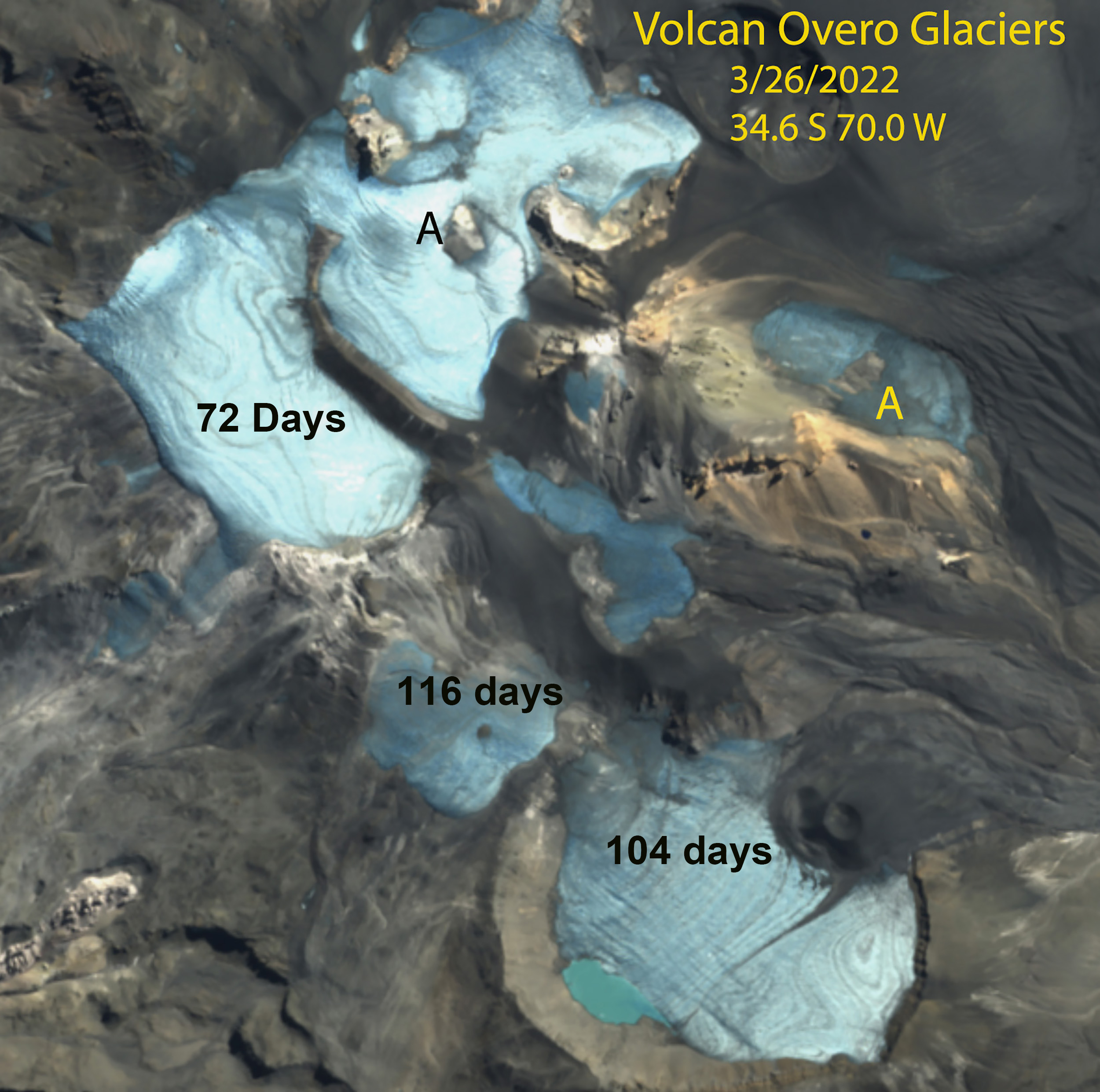
In January 2022 the Central Andes of Argentina and Chile have experienced nearly complete snowcover loss on many glaciers. Volcan Overo, Argentina has four ice masses A-D with limited firn or remaining snowpack. Ice mass E has limited snowcover, but reasonable firn cover extent, not blue dots between firn and bare ice. On Olivares Beta and Gamma Glacier, Chile almost no snowcover remains from Winter 2021, the firn line is limited to the upper portion of both glaciers. This indicates less than 30% of the glacier is an accumulation zone during recent years. There is still six weeks left in the melt season to further reduce this area. The bare surfaces lasted from mid-January into late March leading to extensive mass loss.
For each of the glaciers illustrated here the firn area can be delineated accurately due to the glacier having a significant mass balance loss. The age of the firn cannot be determined without specific knowledge of the glacier or area, but for temperate alpine glaciers firn typically is converted to ice is 5-7 year
The snow cover (S) reamining on Jackston and Blackfoot Glacier in a Sentinel image by early September of 2021 is minimal. The firn area (F) in gray is more extensive.
Adams Glacier with areas of acccumulation (A) and firn (F) in a Sentinel image from Aug. 30, 2021. Green dots indicate the glacier boundary.
Olivares Beta and Gamma Glacier in Sentinel image, with ~10% snowcover remaining and 30% firn cover (blue dots) on January 20, 2022.
Olivares Beta and Gamma Glacier in Sentinel image indicating days of exposure at surface of firn and ice , March 26, 2022.
Volcan Overo, Argentina in January 13, 2022 Sentinel image, with negligible snowcover remaining in mid-summer and firn cover remaining on 30% of the Glacier E.
Volcan Overo in Sentinel image indicating days of exposure at surface of firn and ice , March 26, 2022.
Honeycomb Glacier (H) with evident firn lines below the annual snowline on Oct. 19, 2022 in a Sentinel image.
The southwest side of Kokanee Glacier from the ridge with Cond Peak at the Right and Sawtooth Ridge at center.
By Ben Pelto, PhD, UBC Mitacs Elevate Postdoctoral Research Fellow
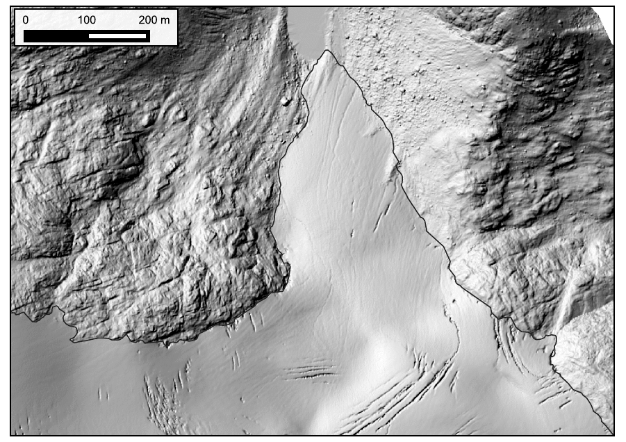
Since 2013 I have been working on the Kokanee Glacier. Located just outside of Nelson in southeastern British Columbia (BC), the Kokanee Glacier is due north of the Washington-Idaho border. This work began as part of a five-year study of the cryosphere in the Canadian portion of the Columbia River. This project was carried out by the Canadian Columbia River Snow and Glacier Research Network — spearheaded by the Columbia Basin Trust. The glacier research, which included the Kokanee Glacier, was led by my former PhD supervisor at the University of Northern British Columbia Dr. Brian Menounos and myself. At the culmination of the project, we published a technical report, and a plain language summary of that report. When the five-year project officially ended in 2018, I learned of a BC Parks program called Living Labs, which offers funding for climate change research in BC Parks, particularly research which documents change and guides protected area management. With Living Labs funding in 2019-2021, I have kept the annual mass balance trips going — now a continuous nine-year record — and a winter mass balance trip in 2021. In conjunction with this, Brian Menounos has secured continued funding (continued from our 5-year project) from BC Hydro for LiDAR surveys of the glacier every spring and fall. These surveys are carried out by the Airborne Coastal Observatory team from the Hakai Institute.
During the 2021 spring trip, we found that the Kokanee Glacier had an average snow depth of 4.4 meters. Using snow density measurements collected with a snow-corer, we found that the winter balance for 2021 was 1.91 meters water equivalent (m w.e.). This value was lower than the 2013-2020 average of 2.18 m w.e. (Pelto et al. 2019).
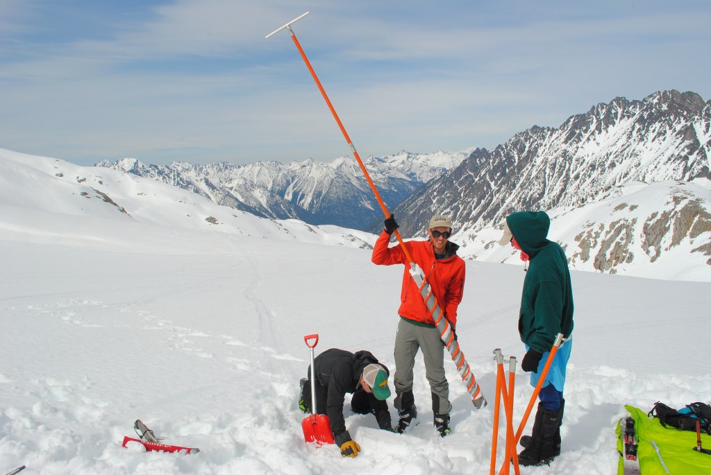
Ali Schroeder probing snow depth on the Kokanee Glacier while Joel McBurney and Drew Copeland look on.
Ben Pelto with the snow corer with Tom Hammond and Micah May on Kokanee Glacier. Photo: Jill Pelto
With a below average winter balance, 2021 would need to feature a cool summer. Instead, multiple heat waves occured, with temperature records being broken across the province. Wildfires burned all over BC and the neighboring US states of Washington and Idaho, swamping the region in smoke for weeks on end. Rather than mitigate for a slightly-below-normal snowpack on the Kokanee, summer 2021 took a blow-torch to glaciers across the region.
We hiked into the Kokanee Glacier on September 12, stopping under a boulder to wait out proximal booms of thunder and flashes in the clouds. We got pelted with bursts of both hail and graupel, and soaked in the rain, before gingerly working our way up boulder field and talus that is climbers route up the Keyhole to the Kokanee Glacier. Like the satellite imagery had shown, there was no snow in sight on the glacier — bare ice only. Instead of my usual camp on the snow, we chose a climbers bivy site to set our tent.
Camp in the Keyhole — a total lack of snow forced us to skip camping on-glacier.
The Keyhole route, a challenging scramble with 43 lb packs.
Stepping out onto the glacier, we immediately ran into difficult terrain, crevasse bridges of snow or firn had collapsed, leaving bedroom-width crevasses gaping open, necessitating an exercise in maze navigation. Our first stop was a stake at 2600 m which typically retains snow (50 to 100 cms), but this year had lost 1.6 meters. In fact, two stakes drilled at the site in 2015 and subsequently buried by snow had melted out, demonstrating that all snow/firn from the intervening years had been lost. This observation clued me in to the magnitude of melt to expect this year.
The first stake visited, showing 1.6 m of melt
Exposed layers of firn in a crevasse by the stake, showing 1.5 m-thick annual layers — now being eaten away by melt.
Travel on the glacier was more challenging in spots, but overall faster, as the total lack of snow meant that most crevasse bridges were gone, requiring less probing of crevasse bridges and roped-travel. Later, using a satellite image from the dates of our visit, I mapped the retained snow cover, limited to two tiny patches high on the glacier’s east side. The accumulation area ratio (AAR), or the ratio of snow cover to bare ice/firn was <0.01, meaning that under 1% of the glacier was covered in snow.
The upper reaches of Kokanee Glacier to Cond Peak (2800 m) with no retained snow in 2021. Bare ice is exposed on the lower half of the image, and firn, or multi-year snow above
The brown surface is multi-year firn, exposed by the loss of snow. In a typical year, the snow line would be visible here. The white surface below the brown is bare glacier ice.
Near infrared-Red-Green 30 cm resolution ortho image of Kokanee Glacier from the Hakai Geospatial/ACO team on Sept. 2, 2021. Note how badly crevassed the glacier is, most crevasses are exposed with no retained snow. The white color and mottled appearance over the upper glacier is a skiff of overnight snow just a few centimeters thick that melted off the next day. Also note bare ice patches exposed under formerly perennial snow patches that have shrunk in recent years and now are disappearing.
Visiting the toe of the glacier, our lowest stake indicated just under 5 m of ice melt, double that of 2020. In May, this location had 3 m of snow; the combined melt of snow and ice (loss of winter snow and glacier ice) is termed the summer mass balance, and at this site was -6.2 m w.e., far higher than the usual -4 m w.e. I also noticed that much of the thin ice along the margin of the toe was gone, and a little rock nunatak (rock island) that appeared in 2015 (images below) became a bite out of the glacier rather than a island. We estimated that the toe experienced 60 m of retreat. Over the past 5 years, the Kokanee has lost an average of 16 m in length annually. Expecting to see above average thinning and retreat, I was still startled to see how diminished and thin the toe looked.
2015: a small hole forms in the glacier margin above the toe, Jesse Milner in the foreground
2021: the hole is now a bite out of the glacier with two prominent rock knobs
A week prior to my field visit, the Hakai Institute ACO team flew a LiDAR survey of the Kokanee Glacier as part of their work with Brian Menounos at UNBC. Comparing this year’s glacier surface with that from last year’s survey, Brian found a whopping 2.55 m of thinning. After mapping the glacier facies (ice/firn/snow) to represent on the density of the observed thinning, this equates to a glacier mass balance of -2.16 m w.e., higher than the previous record loss of -1.20 m w.e. in 2015.
LiDAR-derived height change 2020 to 2021 from 1 m resolution DEMs from Brian Menounos and the Hakai Institue ACO team. The black line is the 2021 glacier outline, note the bite out of the glacier above the toe to the NE corner of the glacier. Small red patches off-ice are seasonal snow patches losing mass. Points represent mass balance observation locations.
Kokanee Glacier terminus from 2015 to 2021. 140 meters of retreat for 23 m/yr. Data in the GIF are from Hakai Institute and Brian Menounos of UNBC ACO glacier surveys.
Back home, I crunched the numbers from our glaciological observations of mass balance (consisting of 14 ablation stakes this year) and calculated a mass balance of -1.97 m w.e. With Brian, I published a paper in 2019 (Pelto et al. 2019) comparing glaciological (field) and geodetic (LiDAR) mass balance estimates and found them to be similar — if some factors like snow and firn density were carefully considered. The small difference between estimates is likely due to timing (the LiDAR mass balance is from 8/26/2020 to 9/3/2021, while the field mass balance is 9/12/2020 to 9/13/2021), and that there was a skiff of fresh snow (likely 5-10 cms) on the glacier during the 2020 LiDAR survey.
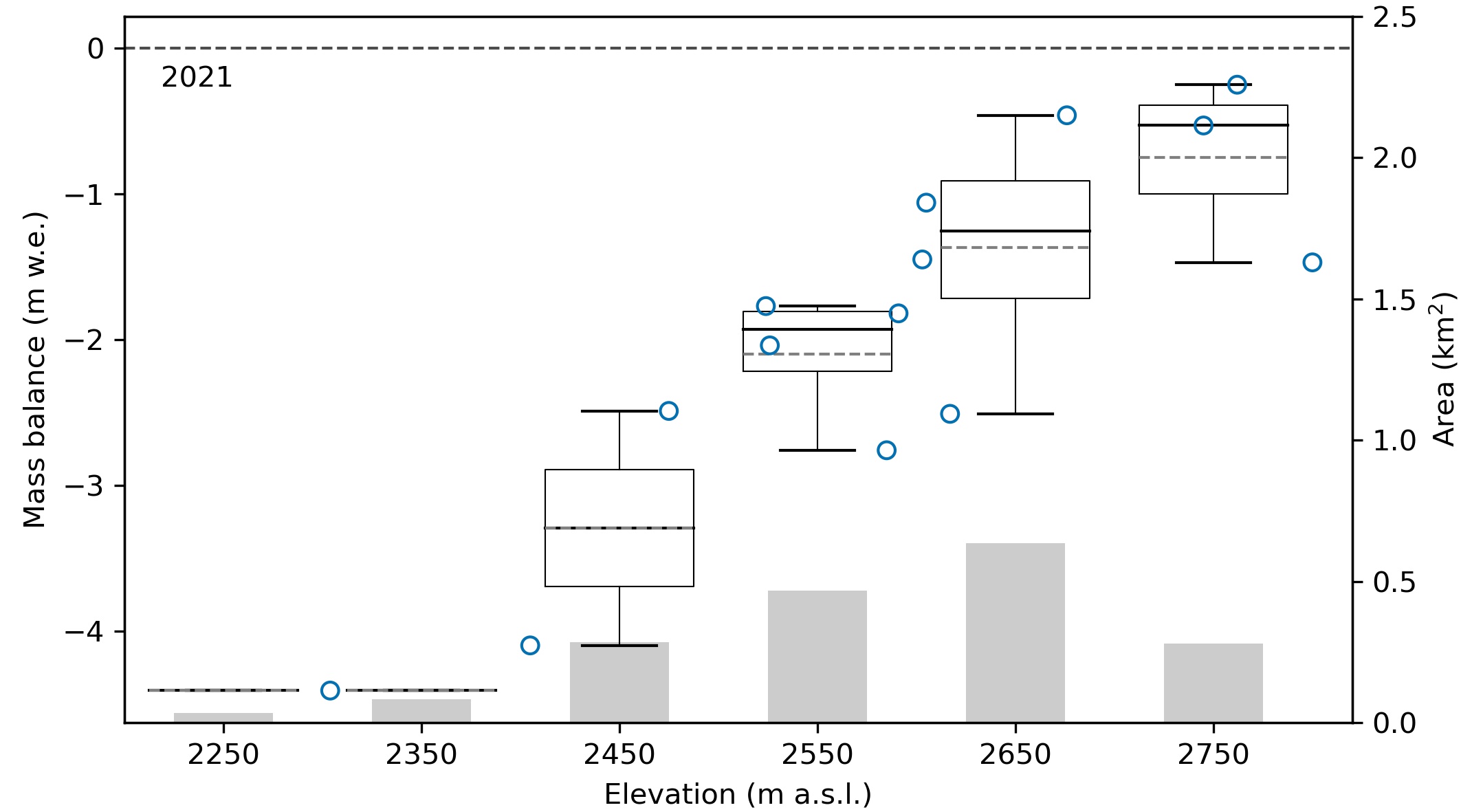
Kokanee 2021 glacier mass balance. Blue dots are observations. The boxplots show the 100 m bins used to estimate glacier-wide mass balance (median line in black, mean dashed grey line). The grey bars depict the area of the glacier for each 100 m elevation-band
Seasonal and annual mass balance for Kokanee Glacier from LiDAR and glaciological measurements for each balance year from 2013 to 2021 with 2σ uncertainties.
In 2017, I visited the Kokanee Glacier to measure it’s ice thickness using ice-penetrating radar. I found that the glacier on average was 43 m thick using my measurements to tune a glacier model. I published these results in the Journal of Glaciology (Pelto et al. 2020). In the five years since that work, the glacier has lost over 4.8 m of total thickness. That equates to a loss of over 11% of its total volume. 2021 alone wasted away 6% of the glacier’s total volume — an eye-watering number for a single year.
Cumulative mass balance for Kokanee Glacier 2013-2021 from both field and LiDAR measurments. LiDAR-derived mass balance began in 2016.
The heat of 2021 was an outlier, but years like 2021 and 2015 take a toll on the glaciers. Currently, glaciers in western North America are losing around 0.75 m of thickness per year (according to my work in the Columbia Basin (Pelto et al. 2019) and work by Brian Menounos for all of western North America (Menounos et al. 2018)). The better years for Kokanee Glacier (2016 mass balance: +0.12 m w.e.) pale in comparison. That meager surplus was lost the very next year (2017).
Herein lies the issue, positive mass balance years in recent decades are not large enough to offset even average years; hot dry summers take years off the lifespan of glaciers across western North America.
Losing 6% of it’s total volume in 2021, the best we can hope for Kokanee Glacier is a few near-neutral or positive mass balance years to cover back up the exposed firn, to keep the glacier albedo from becoming too dark and increasing the rate at which ice can melt.
The southwest side of Kokanee Glacier from the ridge with Cond Peak at the Right and Sawtooth Ridge at center.
Since 2013 I have been working on the Kokanee Glacier. Located just outside of Nelson in southeastern British Columbia (BC), the Kokanee Glacier is due north of the Washington-Idaho border. This work began as part of a five-year study of the cryosphere in the Canadian portion of the Columbia River. This project was carried out by the Canadian Columbia River Snow and Glacier Research Network — spearheaded by the Columbia Basin Trust. The glacier research, which included the Kokanee Glacier, was led by my former PhD supervisor at the University of Northern British Columbia Dr. Brian Menounos and myself. At the culmination of the project, we published a technical report, and a plain language summary of that report. When the five-year project officially ended in 2018, I learned of a BC Parks program called Living Labs, which offers funding for climate change research in BC Parks, particularly research which documents change and guides protected area management. With Living Labs funding in 2019-2021, I have kept the annual mass balance trips going — now a continuous nine-year record — and a winter mass balance trip in 2021. In conjunction with this, Brian Menounos has secured continued funding (continued from our 5-year project) from BC Hydro for LiDAR surveys of the glacier every spring and fall. These surveys are carried out by the Airborne Coastal Observatory team from the Hakai Institute.
During the 2021 spring trip, we found that the Kokanee Glacier had an average snow depth of 4.4 meters. Using snow density measurements collected with a snow-corer, we found that the winter balance for 2021 was 1.91 meters water equivalent (m w.e.). This value was lower than the 2013-2020 average of 2.18 m w.e. (Pelto et al. 2019).
Ali Schroeder probing snow depth on the Kokanee Glacier while Joel McBurney and Drew Copeland look on.
Ben Pelto with the snow corer with Tom Hammond and Micah May on Kokanee Glacier. Photo: Jill Pelto
With a below average winter balance, 2021 would need to feature a cool summer. Instead, multiple heat waves occured, with temperature records being broken across the province. Wildfires burned all over BC and the neighboring US states of Washington and Idaho, swamping the region in smoke for weeks on end. Rather than mitigate for a slightly-below-normal snowpack on the Kokanee, summer 2021 took a blow-torch to glaciers across the region.
We hiked into the Kokanee Glacier on September 12, stopping under a boulder to wait out proximal booms of thunder and flashes in the clouds. We got pelted with bursts of both hail and graupel, and soaked in the rain, before gingerly working our way up boulder field and talus that is climbers route up the Keyhole to the Kokanee Glacier. Like the satellite imagery had shown, there was no snow in sight on the glacier — bare ice only. Instead of my usual camp on the snow, we chose a climbers bivy site to set our tent.
Camp in the Keyhole — a total lack of snow forced us to skip camping on-glacier.
The Keyhole route, a challenging scramble with 43 lb packs.
Stepping out onto the glacier, we immediately ran into difficult terrain, crevasse bridges of snow or firn had collapsed, leaving bedroom-width crevasses gaping open, necessitating an exercise in maze navigation. Our first stop was a stake at 2600 m which typically retains snow (50 to 100 cms), but this year had lost 1.6 meters. In fact, two stakes drilled at the site in 2015 and subsequently buried by snow had melted out, demonstrating that all snow/firn from the intervening years had been lost. This one observation clued me in to the magnitude of melt to expect this year.
The first stake visited, showing 1.6 m of melt
Exposed layers of firn in a crevasse by the stake, showing 1.5 m-thick annual layers — now being eaten away by melt.
Travel on the glacier was more challenging in spots, but overall faster, as the total lack of snow meant that most crevasse bridges were gone, requiring less probing of crevasse bridges and roped-travel. Later, using a satellite image from the dates of our visit, I mapped the retained snow cover, limited to two tiny patches high on the glacier’s east side. The accumulation area ratio (AAR), or the ratio of snow cover to bare ice/firn was <0.01, meaning that under 1% of the glacier was covered in snow.
The upper reaches of Kokanee Glacier to Cond Peak (2800 m) with no retained snow in 2021. Bare ice is exposed on the lower half of the image, and firn, or multi-year snow above
The brown surface is multi-year firn, exposed by the loss of snow. In a typical year, the snow line would be visible here. The white surface below the brown is bare glacier ice.
Visiting the toe of the glacier, our lowest stake indicated just under 5 m of ice melt, double that of 2020. In May, this location had 3 m of snow; the combined melt of snow and ice (loss of winter snow and glacier ice) is termed the summer mass balance, and at this site was -6.2 m w.e., far higher than the usual -4 m w.e. I also noticed that much of the thin ice along the margin of the toe was gone, and a little rock nunatak (rock island) that appeared in 2015 (images below) became a bite out of the glacier rather than a island. We estimated that the toe experienced 60 m of retreat. Over the past 5 years, the Kokanee has lost an average of 16 m in length annually. Expecting to see above average thinning and retreat, I was still startled to see how diminished and thin the toe looked.
2015: a small hole forms in the glacier margin above the toe, Jesse Milner in the foreground
2021: the hole is now a bite out of the glacier with two prominent rock knobs
A week prior to my field visit, the Hakai Institute ACO team flew a LiDAR survey of the Kokanee Glacier as part of their work with Brian Menounos at UNBC. Comparing this year’s glacier surface with that from last year’s survey, Brian found a whopping 2.55 m of thinning. After mapping the glacier facies (ice/firn/snow) to represent on the density of the observed thinning, this equates to a glacier mass balance of -2.16 m w.e., higher than the previous record loss of -1.20 m w.e. in 2015.
LiDAR-derived height change 2020 to 2021 from 1 m resolution DEMs from Brian Menounos and the Hakai Institue ACO team. The black line is the 2021 glacier outline, note the bite out of the glacier above the toe to the NE corner of the glacier. Small red patches off-ice are seasonal snow patches losing mass. Points represent mass balance observation locations.
Back home, I crunched the numbers from our glaciological observations of mass balance (consisting of 14 ablation stakes this year) and calculated a mass balance of -1.97 m w.e. With Brian, I published a paper in 2019 (Pelto et al. 2019) comparing glaciological (field) and geodetic (LiDAR) mass balance estimates and found them to be similar — if some factors like snow and firn density were carefully considered. The small difference between estimates is likely due to timing (the LiDAR mass balance is from 8/26/2020 to 9/3/2021, while the field mass balance is 9/12/2020 to 9/13/2021), and that there was a skiff of fresh snow (likely 5-10 cms) on the glacier during the 2020 LiDAR survey.
Kokanee 2021 glacier mass balance. Blue dots are observations. The boxplots show the 100 m bins used to estimate glacier-wide mass balance (median line in black, mean dashed grey line). The grey bars depict the area of the glacier for each 100 m elevation-band
In 2017, I visited the Kokanee Glacier to measure it’s ice thickness using ice-penetrating radar. I found that the glacier on average was 43 m thick using my measurements to tune a glacier model. I published these results in the Journal of Glaciology (Pelto et al. 2020). In the five years since that work, the glacier has lost over 4.8 m of total thickness. That equates to a loss of over 11% of its total volume. 2021 alone wasted away 6% of the glacier’s total volume — an eye-watering number for a single year.
Cumulative mass balance for Kokanee Glacier 2013-2021 from both field and LiDAR measurments. LiDAR-derived mass balance began in 2016.
The heat of 2021 was an outlier, but years like 2021 and 2015 take a toll on the glaciers. Currently, glaciers in western North America are losing around 0.75 m of thickness per year (according to my work in the Columbia Basin (Pelto et al. 2019) and work by Brian Menounos for all of western North America (Menounos et al. 2018)). The better years for Kokanee Glacier (2016 mass balance: +0.12 m w.e.) pale in comparison. That meager surplus was lost the very next year (2017).
Herein lies the issue, positive mass balance years in recent decades are not large enough to offset even average years; hot dry summers take years off the lifespan of glaciers across western North America.
Losing 6% of it’s total volume in 2021, the best we can hope for Kokanee Glacier is a few near-neutral or positive mass balance years to cover back up the exposed firn, to keep the glacier albedo from becoming too dark and increasing the rate at which ice can melt.
The North Cascade Glacier Climate Project 2020 field season was our 37th consecutive year of glacier observations. The field team consisted of Cal Waichler, Mariama Dryak, Jill Pelto and Mauri Pelto. Each team member has studied glaciers on more than one continent and is passionate about science communication, using either art, videography or writing.
Mauri Pelto, Jill Pelto, Cal Waichler and Mariama Dryak from left to right on Easton Glacier the 2020 field team (Jill Pelto Photograph).
At Columbia Glacier the field team was joined by Michelle Tanz a Wlderness Stewardship Fellow for the National Forest Service. The initial observation was that the 2 km bushwhack around Blanca Lake has gotten much brushier as the alpine meadow becomes more sub-alpine. Columbia Glacier is a low elevation avalanche fed glacier that developed a new lake at its terminus a decade ago that continues to expand. The east side of the glacier has been thinning much faster than the west side altering the very shape of the glacier. Observed snowpack in 2020 was below average except for on the slopes of the main west side avalanche fans. The upper basin at 1550-1650 m averaged 2.2 m of snowpack at the 70 probing locations, which is 70% of normal. This snowpack will not survive the melt season, only snowpack in the main avalanche fans will remain. Terminus retreat has been 217 m since our first observation in 1984.
Lower Curtis Glacier is fed by avalanches from the slopes of Mt. Shuskan. We were joined in the field by Tom Hammond for the 17th consecutive year and artist Claire Giordano. There was a similar pattern to Columbia Glacier in that snowpack across most of the glacier was below average, while the primary avalanche fan on the east side had above average snowpack. The avalanche fans on the central headwall of the glacier fed from the Upper Curtis Glacier continue to thin rapdily, as avalanching has declined. The terminus slope which had been a daunting 42 degrees in 2015 is now 34 degrees. For the sixteenth consecutive year we had at least one artist in the field, below are field sketches from Cal Waichler and Jill Pelto and a painting from Claire Giordano. We will be combining the science findings and art in forthcoming articles on Lower Curtis and Easton Glacier.
Claire Giordano working on painting of Lower Curits Glacier and Mt. Shusksan (Mariama Dryak Photograph).
Jill Pelto completes sketch, while sitting on ice chunk, of Easton Glacier icefall (Mariama Dryak Photograph).
Cal Waichler annotated story board style sketches both capture and explain the scene at Columbia Glacier (Mariama Dryak Photograph).
Rainbow Glacier has a terminus that is largely buried by avalanches, but is now is close to detaching from the main valley glacier. Snowpack at 1700 m averaged 2.4 m which is 75% of average. The saddle with Mazama glacier at 2000-2100 m averaged 3.9 m, which is 85% of normal. Subglacial bedrock knobs continue to become more prominent in expanding crevassing above and slope below the slope change, as the glacier thins.
Sholes Glacier had the highest percentage of surface blue ice of the glaciers observed. Snowpack had been reduced from at a rate of 8 cm/day during the first week of August, a relatively warm period. A snow cave at the terminus could be entered from a terminus crevasse that was 50 m long, 10 m wide and 2-5 m high. This is indicative of a relatively stagnant rapidly retreating terminus. From 2014-2020 the glacier has retreated 80 m, which is equivalent to the retreat from 1990-2014. Glacier runoff continues to be monitored just below the glacier by the Nooksack Tribe, while we provide continued rating curve development. Runoff during early August was averaging 0.25 m3/sec.
On Easton Glacier the terminus slope was the gentlest we had seen in our 31 years of consecutive observations. The terminus has retreated 430 m in this period. The significant thinning in the last few years had both reduced crevassing in the lowest icefall, but had reduced crevasse depth. Jill Pelto has been observing the crevasses depth in all the open crevasses in this icefall over the last decade. The biggest change has been from 2018-2020 with average depth being reduced by 40%. Snowpack on the bench at 2000 m averaged 2.4 m at the 45 observation sites, which is 75% of normal. The snowpack remained below normal at 2200 m, before a sharp increase to above normal snowpack averageing 5.1 m in 14 crevasse observations at ~2500 m. At this same elevation retained snowpack, now firn from previous years averaged 2.25 m. Based on the storm stratigraphy one significant difference was the result of an atmospheric river precipitation event of 12+ cm of precipitation from 1/31-2/2, that led to a snow depth and snow water equivalent decline at the Middle Fork Nooksack Snotel at 1550 m, while above 2300 m this all fell as snow. The freezing levels were above 2000 m for much of the event. The better high elevation snowpack will help Easton Glacier’s mass balance in 2020.
Easton Camp from adjacent to 1990 terminus position (Jill Pelto Photograph).
Crevasse stratigraphy at 2500 m on Easton Glacier indicates an average of 5.1 m of 2020 snowpack in crevasses and 2.25 m for previous annual layers from the 2016-2019 period (Mauri Pelto and Jill Pelto Photographs)
The North Cascade Glacier Climate Project 2020 field season was our 37th consecutive year of glacier observations. The field team consisted of Cal Waichler, Mariama Dryak, Jill Pelto and Mauri Pelto. Each team member has studied glaciers on more than one continent and is passionate about science communicatio, using either art, videography or writing.
Mauri Pelto, Jill Pelto, Cal Waichler and Mariama Dryak from left to right on Easton Glacier the 2020 field team (Jill Pelto Photograph).
At Columbia Glacier the field team was joined by Michelle Tanz a Wlderness Stewardship Fellow for the National Forest Service. The initial observation was that the 2 km bushwhack around Blanca Lake has gotten much brushier as the alpine meadow becomes more sub-alpine. Columbia Glacier is a low elevation avalanche fed glacier that developed a new lake at its terminus a decade ago that continues to expand. The east side of the glacier has been thinning much faster than the west side altering the very shape of the glacier. Observed snowpack in 2020 was below average except for on the slopes of the main west side avalanche fans. The upper basin at 1550-1650 m averaged 2.2 m of snowpack at the 70 probing locations, which is 70% of normal. This snowpack will not survive the melt season. Terminus retreat has been 217 m since our first observation in 1984.
Lower Curtis Glacier is fed by avalanches from the slopes of Mt. Shuskan. We were joined in the field by Tom Hammond for the 17th consecutive year and artist Claire Giordano. There was a similar pattern to Columbia Glacier in that snowpack across most of the glacier was below average, while the primary avalanche fan on the east side had above average snowpack. The avalanche fans on the central headwall of the glacier fed from the Upper Curtis Glacier continue to thin rapdily, as avalanching has declined. The terminus slope which had been a daunting 42 degrees in 2015 is now 34 degrees. For the sixteenth consecutive year we had at least one artist in the field, below are field sketches from Cal Waichler and Jill Pelto and a painting from Claire Giordano. We will be combining the science findings and art in forthcoming articles.
Claire Giordano working on painting of Lower Curits Glacier and Mt. Shusksan (Mariama Dryak Photograph).
Jill Pelto completes sketch, while sitting on ice chunk, of Easton Glacier icefall (Mariama Dryak Photograph).
Cal Waichler annotated story board style sketches both capture and explain the scene at Columbia Glacier (Mariama Dryak Photograph).
Rainbow Glacier has a terminus that is largely buried by avalanches, but is now is close to detaching from the main valley glacier. Snowpack at 1700 m averaged 2.4 m which is 75% of average. The saddle with Mazama glacier at 2000-2100 m averaged 3.9 m, which is 85% of normal. Subglacial bedrock knobs continue to become more prominent in expanding crevassing above and slope below the slope change, as the glacier thins.
Sholes Glacier had the highest percentage of surface blue ice of the glaciers observed. Snowpack had been reduced from at a rate of 8 cm/day during the first week of August, a relatively warm period. A snow cave at the terminus could be entered from a terminus crevasse that was 50 m long, 10 m wide and 2-5 m high. This is indicative of a relatively stagnant rapidly retreating terminus. From 2014-2020 the glacier has retreated m, which is equivalent to the retreat from 1990-2014.
On Easton Glacier the terminus slope was the gentlest we had seen in our 31 years of consecutive observations. The terminus has retreated 430 m in this period. The significant thinning in the last few years had both reduced crevassing in the lowest icefall, but had reduced crevasse depth. Jill Pelto has been observing the crevasses depth in all the open crevasses in this icefall over the last decade. The biggest change has been from 2018-2020 with average depth being reduced by 40%. Snowpack on the bench at 2000 m averaged 2.4 m at the 45 observation sites, which is 75% of normal. The snowpack remained below normal at 2200 m, before a sharp increase to above normal snowpack averageing 5.1 m in 14 crevasse observations at ~2500 m. At this same elevation retained snowpack, now firn from previous years averaged 2.25 m. Based on the storm stratigraphy the big difference seemed to be the result of an atmospheric river precipitation event of 12+ cm from 1/31-2/2, that led to a snow depth decline and snow water equivalent decline at the Middle Fork Nooksack Snotel at 1550 m, while above 2300 m this all fell as snow. The freezing levels were above 2000 m for much of the event. The better high elevation snowpack will help Easton Glacier’s mass balance in 2020.
Easton Camp from adjacent to 1990 terminus position (Jill Pelto Photograph).
Crevasse stratigraphy at 2500 m on Easton Glacier indicates an average of 5.1 m of 2020 snowpack in crevasses and 2.25 m for previous annual layers from the 2016-2019 period (Mauri Pelto and Jill Pelto Photographs)


 The lack of retained snowpack is evident at glaciers around the world in 2022.
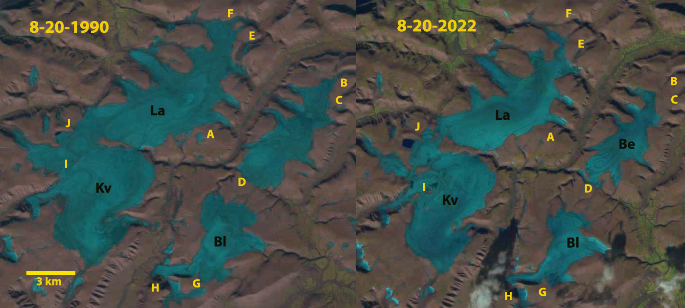 Langjokulen (La), Kvitisen (Kv), Bergfonna (Be) and Blaisen (Bl) ice caps on Edgeøya in Sentinel image from 8-20-2022 illustrating the lack of snowcover, limited firn areas and numerous annual layers.