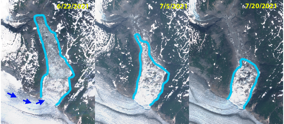
Sheridan Glacier, Alaska Retreat Causes Rapid Lake Expansion

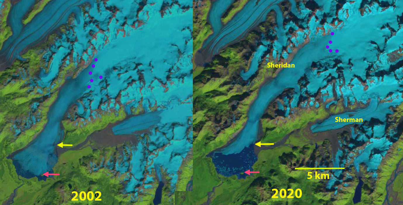
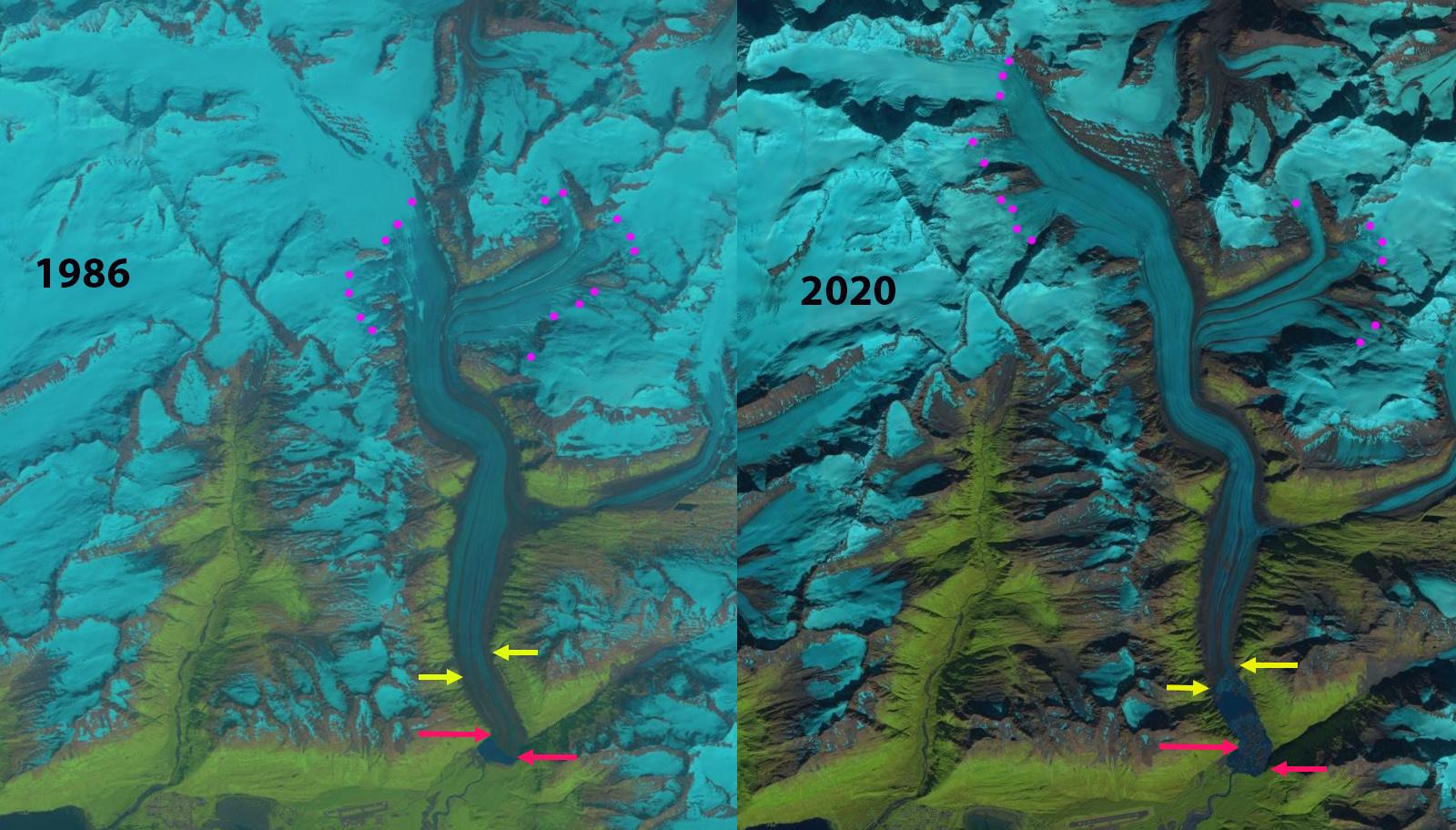
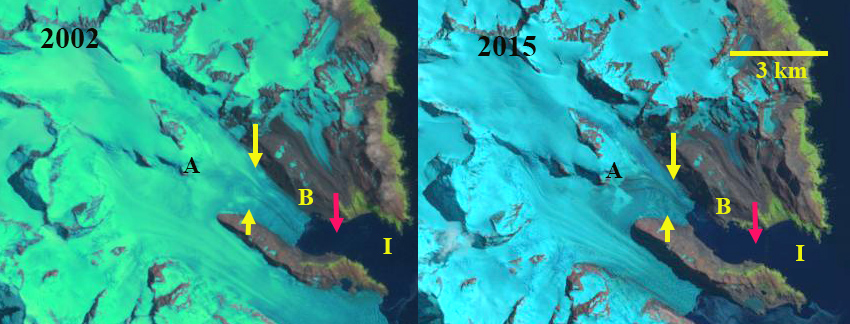
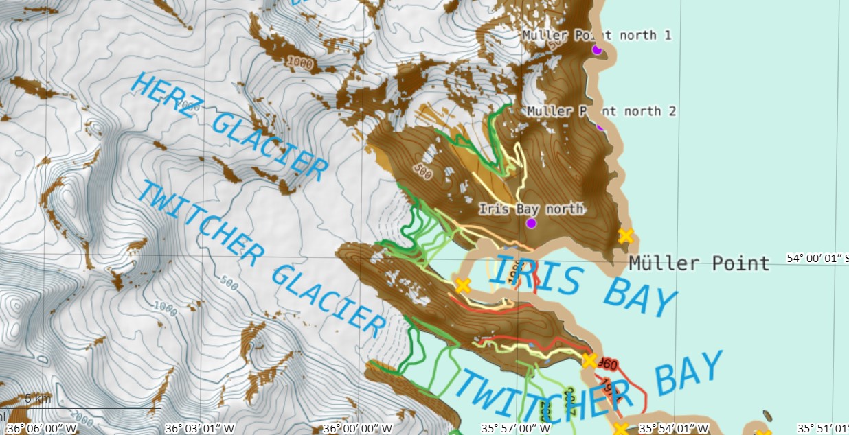
Sheridan Glacier in 2002 and 2020 Landsat images illustrating retreat of the margin and expansion of the lake. Red arrow is 2002 margin on small island, yellow arrow is 2020 terminus location just north of Sherman Glacier stream and purple dots are the snowline.

Sheridan Glacier in the Chugach Mountains of Alaska begins at 1500 m and flow southwest out of the mountains with the terminus spreading out in a  lake basin on the low slope coastal plain.  Sheridan Lake is a proglacial lake at the terminus that drains into the Sheridan River which 12 km later reaches tidewater. From 1950 to 2000 Sheridan Glacier experienced modest retreat, with the terminus, with a fringing proglacial Sheridan Lake persisting, followed by a terminus disintegration from2000-2016. (Shugar et al 2018). Here we examine Landsat imagery from 2002-2020 to identify the retreat and resultant lake expansion.

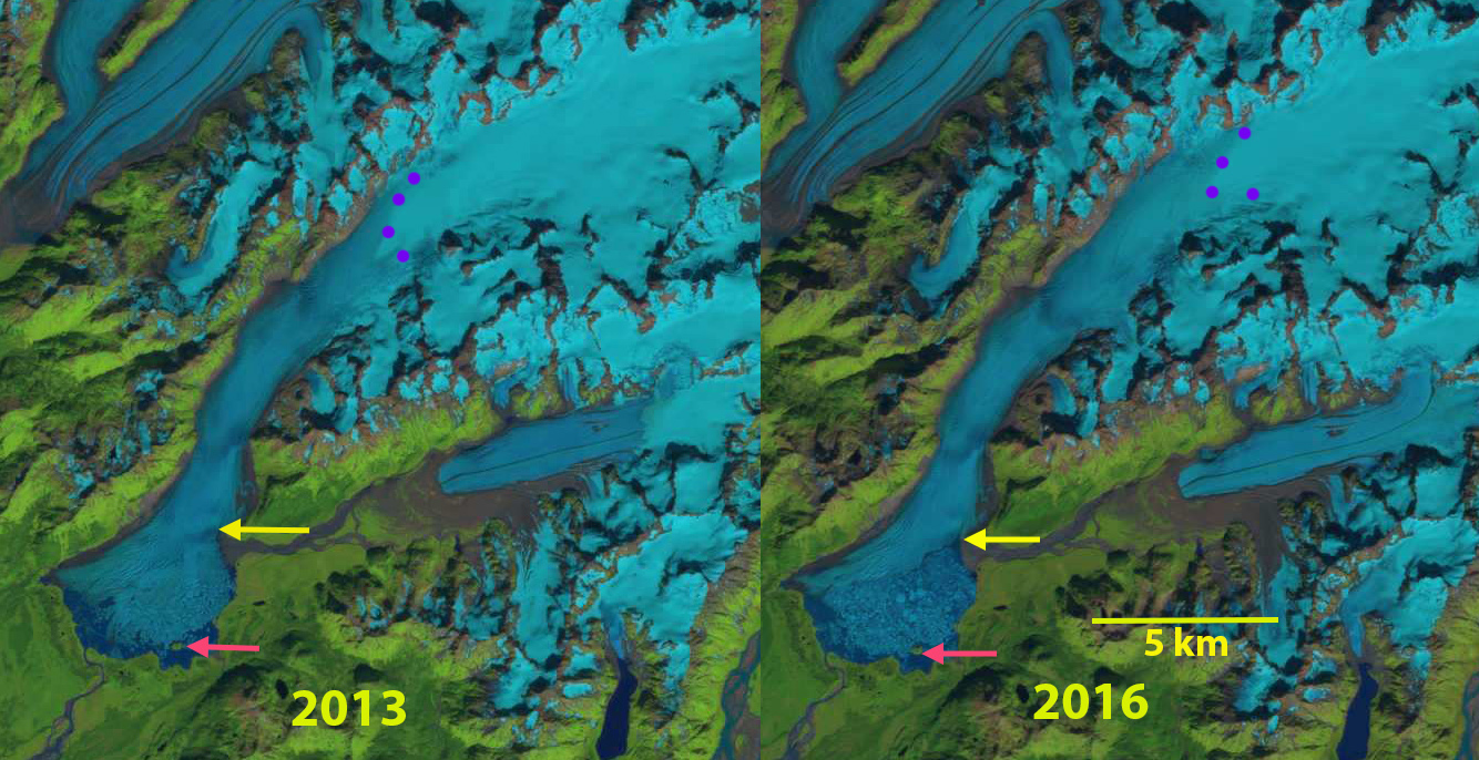
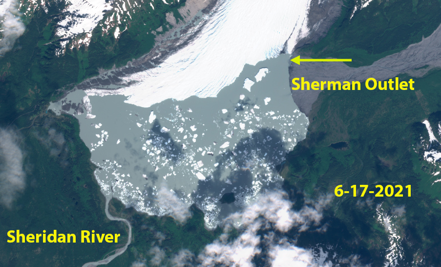
In 2002 the proglacial lake has an area of 3.8 km2, with the terminus crossing one small island in the lake.  The snowline is at 750 m. In 2013 there is a 4 km2 terminus area that has disintegrated, the terminus has retreated off of the island.  The snowline is at 850 m. By 2016 the terminus has retreated north of the glacier stream from Sherman Glacier entering from the east, though much of the lake is still filled with an iceberg melange.  The snowline is at 925 m.  In 2020 the Sheridan Lake area has expanded to 11.2 km2, representing a retreat of 7.4 km2 since 2002.  The snowline in 202o is at 970 m.  In June 2021 there are a significant number of new icebergs indicating ongoing lake expansion during 2021.  Sheridan Lake is not a large glacial lake by Alaskan standards, but is bigger than any glacial lake in most alpine regions such as the Himalaya.  The ability to be so large is in large part due to the ability to develop larger basin on low sloped terrain near the coastline.

The amount of terminus retreat here is less than that at Excelsior Glacier or Yakutat Glacier, but the lake expansion rate is comparable to Excelsior Glacier.

Sheridan Glacier in 2013 and 2016 Landsat images illustrating the breakup of a large terminus region generating a melange of icebergs. Red arrow is 2002 margin on small island, yellow arrow is 2020 terminus location just north of Sherman Glacier stream and purple dots are the snowline.

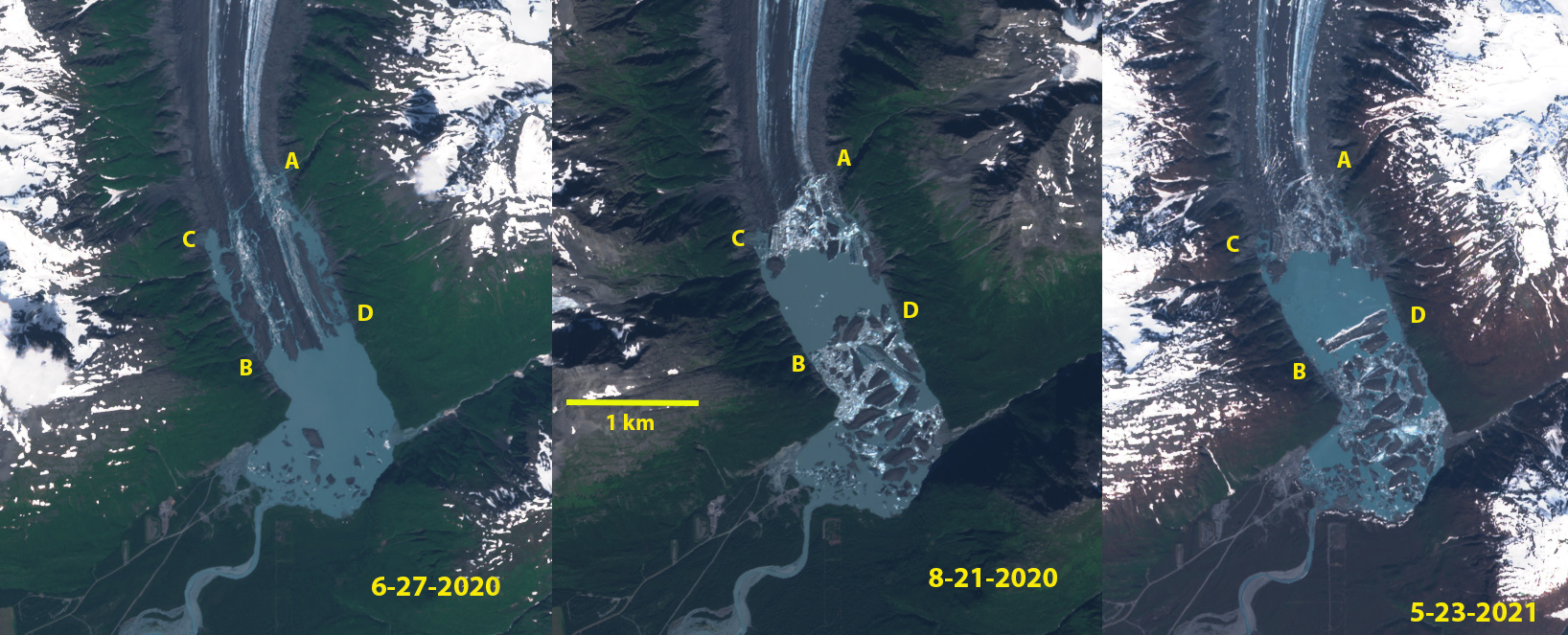
June 2021 Sentinel Image indicating considerable new iceberg activity leading to ongoing lake expansion in 2021.


Paarliit Sermia, Southern Greenland Terminus Separation

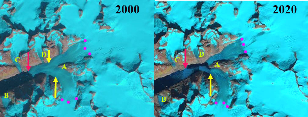
Paarliit Sermia in 2000 and 2020 Landsat images.  The red arrow indicates the 2000 terminus location and the yellow arrow the 2020/21 terminus location. A denotes the junction of two main glacier branches, while B,C and D indicate tributaries

Paarliit Sermia is one of the most southerly tidewater glaciers in Greenland.  It is an outlet glacier of a mountain icefield and not part of the main ice sheet.  Similar to other icefield outlet glaciers whether in Alaska  (Dawes Glacier) or Patagonia (Upsala) retreat is leading to glacier separation. Greenland tidewater outlet glaciers in this region have experienced substantial retreat since 1990, Weidick et al (2012) and Howat and Eddy (2011).  There was also an increase in sea surface temperature (Straneo et al, 2013).  Moon et al (2020) noted a there is a rapid reconfiguration of the Greenland Ice Sheet Coastal margin due to retreat. The retreat of glaciers in southern Greenland is changing the physical geography and hence the physical oceanography of the fjords.  Here we examine Landsat imagery from 2000-2021 to identify the changes of Paarliit Sermia.

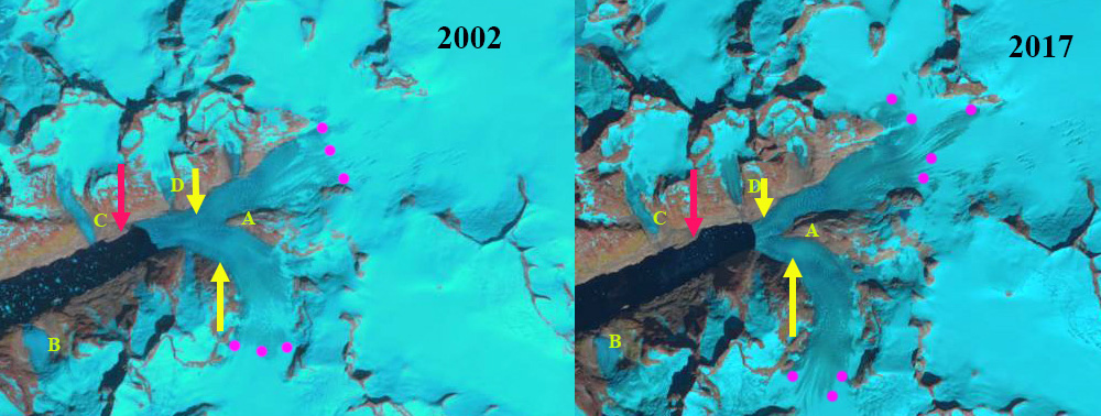
The Greenland Topographic map indicates the terminus down fjord from tributary B, 6.5 km from the main junction of two glacier branches at Junction A.  Tributary B, C and D all feed the main glacier. By 2000 the glacier has retreated beyond tributary B and C.  The snowline is between 550 m and 600 m in 2000 and 2002. In 2017 the glacier has retreated beyond Tributary D, and the snowline is slightly above 600 m. The two main branches are still joined, with the terminus now just 1 km from Junction A. Former Tributary C and D no longer reach tidewater. In 2020 the two main branches have separated and Point A is no longer a junction glacier has separated into two branches, the snowline is at ~600 m. In mid-June of 2021, the snowline is already at 500 m, despite being early in summer.  Paarliit Sermia has retreated 2.4 km from 2000-2021, a rate of ~200 m/year.

Nearby Kangersuneq Quingordleq Glacier retreated 2.8 km from 1999-2016. To the northeast Qaleraliq has experienced a 3.2 km retreat of its west arm and 1.2 km of its east arm from 1992 to 2012.   To the northeast Tingmiarmiit Glacier’s retreat from 1999-2015 has led to complete separation of the western and northern tributary. The western tributary is the main glacier and has retreated 2.4 km and the northern tributary has retreated 2.2 km in the 16 year period. In the case of nearby Tasermiut Fjord retreat has led to the fjord losing its tidewater connection.

Paarliit Sermia in 2002 and 2017 Landsat images.  The red arrow indicates the 2000 terminus location and the yellow arrow the 2020/21 terminus location. A denotes the junction of two main glacier branches, while B,C and D indicate tributaries

Paarliit Sermia in 1980’s Greenland Topographic map (from Nuna GIS) and 2021 Landsat images.  In the Landsat image the red arrow indicates the 2000 terminus location and the yellow arrow the 2020/21 terminus location.  On both map and image A denotes the junction of two main glacier branches, while B,C and D indicate tributaries

Dawes Glacier, Alaska Retreat Driven Separation

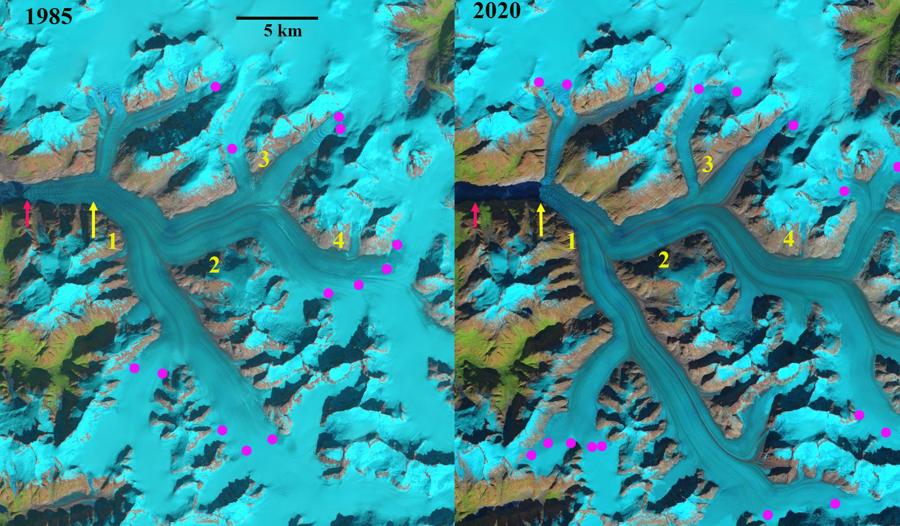
Dawes Glacier retreat in 1985 and 2020 Landsat images. Red arrow 1985 terminus, yellow arrow 2020 terminus. Point 1-3 are tributaries joining the main glacier. The glacier is about to separate into two calving termini.

Dawes Glacier terminates at the head of Endicott Arm in the Tracy Arm-Fords Terror Wilderness of southeast Alaska. Endicott Arm is a fjord that has been extending with glacier retreat, and is now  58 km long.  Dawes is a major outlet glacier of the rapidly thinning Stikine Icefield. Melkonian et al (2016) observed a rapid thinning of the Stikine Icefield of -0.57 m/year from 2000-2014.  Here we compare Landsat imagery to identify changes from 1985-2020. Endicott Arm is host to a population of harbor seals that prefer hauling out on icebergs during the day supplied by Dawes Glacier (Blundell and Pendleton, 2015)

In 1985 the glacier terminated at the red arrow in each image, the tributaries at points 1,2 and 4 connected with the main glacier. Point 3 is the junction point of two tribuataries. The northern arm is 1.3 km wide and the eastern arm is  2.5 km wide.  The snowline was at 1100 m.  In 1987 the snowline on the glacier was at 1150 m.  By 1999 the glacier had retreated 900 m since 1985 and the snowline was at  1300 m.  In 2019 the tributaries at Point 1, 2 and 4 have detached from the the main glacier. At Point 3 the northern arm has declined to 0.7 km wide and the eastern arm is  1.8 km wide.  In 2019 the snowline is at a record 1450-1500 m.This fragmentation of Dawes Glacier will continue, which leads to a reduced ice flux to the terminus reach. By 2020 Dawes Glacier has retreated 3.8 km since 1985, a rate of 105 m/year. The snowline is again exceptionally high at 1400-1450 m. Of equal importance the glacier terminus is separating into two individual calving termini, that could become fully separate this summer of 2021.

McNabb et al (2014) reported a thinning of 62 m/year from 1985-2013. The reduced inflow and up glacier thinning is ongoing and has driven the increased retreat rate despite a reduction in water depth at the cavling front. A key mechanism for retreat over the last century has been calving. The 2007 Hydrographic map of the area indicates water depth at the calving front still over 100 m, with a depth of 150 m 1 km down fjord of the terminus (see bottom image). The  depth more recently has declined to 60 m at the calving front in 2013 (Melkonian et al 2016), yet retreat has increased driven by enhanced melting. The glacier thinning is continuing, but the retreat rate will decline as the fjord head is approached.

At the glacier front the velocity was 13 m/day in 1985, increasing to 18 m/day by 1999 and declining to 5 m/day by 2014 (Melkonian et al 2016).

This reduction will reduce calving and iceberg production. As icebergs are reduced harbor seals will be disappointed as they prefer icebergs to haul out on. The Alaska Department of Fish and Game has been monitoring harbor seals in the fjord and noting that females travel to pup on the icebergs in the spring and also utilize them for mating.  ADFG attached satellite tags to harbor seals to monitor their movements beyond the breeding and puppin season finding  that that adult and sub-adult seals captured in Endicott Arm spent the late summer and fall months in Stephens Passage, Frederick Sound, and Chatham Strait. How will a reduction in icebergs affect this population overall?

The retreat leading to separation is also happening at other outlets of Stikine Icefield such as Baird Glacier and Sawyer Glacier.

Dawes Glacier retreat in 1985 and 2020 Landsat images. Red arrow 1985 terminus, yellow arrow 2020 terminus and purple dots the snowline. Point 1-4 are tributaries joining the main glacier.

Dawes Glacier retreat in 1985 and 2020 Landsat images. Red arrow 1985 terminus, yellow arrow 2020 terminus and purple dots the snowline. Point 1-4 are tributaries joining the main glacier.

Dawes Glacier in June 2021 Sentinel image. Indicating the impending separation of the terminus.

Hydrograh of Endioctt Arm from 2007.

Jacobsen Glacier, BC Separation Nearly Complete

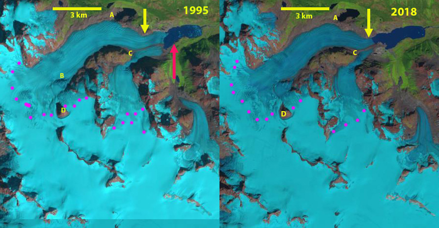
Jacobsen Glacier in Landsat images from 1987 and 2019. Red arrow 1987 terminus location, yellow arrow 2019 terminus location and pink dots the snowline. Point A indciates ice marginal lake in 1987, Point C is the glacier junction, Point B an emerging rock rib and Point D a nunatak.

Jacobsen Glacier is part of the Monarch Icefield of the Coastal Range of British Columbia. VanLooy and Forster (2008) noted that the glacier retreated at a rate of 30 meters/year from 1974 to 1992 and 47 meters/year from 1992-2000. Menounos et al (2018) identified a mass loss for glaciers in this region of ~0.5 m year from 2000-2018 which is driving retreat. The glacier is at the headwaters of jacobsen Creek, which joins the Talchako River and then Bella Coola River.  The Bella Coola River is one of the most important salmon producing rivers on the British Columbia’s central coast. It supports the largest chinook and chum salmon populations, surveyed at 23k and 190k in surveys during the last decade (Pacific Salmon Foundation, 2021)  The sockeye and pink salmon runs have largely collapsed this century (Pacific Salmon Foundation, 2021). In this post we examine Landsat satellite imagery from 1987-2019 and Sentinel imagery from 2021 to illustrate the changes.

In 1987 the glacier terminated in a 1.8 km long proglacial lake at an altitude of ~1080 m .  The north margin had a separate terminus in the proglacial lake at Point A.  The terminus in the main proglacial lake 900 m wide. At Point B there is an icefall, but not exposed bedrock. The snowline was at 2050 m.  By 1995 the glacier had retreated 500 m.  The glacier was in contact with the proglacial lake at Point A.  The snowline was at 2100 m. By 2000 the glacier has retreated from the proglacial lake at Point A, due to thinning.  In 2016 the snowline is at 2150 m.  The glacier is now separated from the proglacial lake at Point A by ~500 m.  The southern tributary no longer reaches the expanding proglacial lake. In 2018 there is bedrock exposed at Point B.  The snowline is at 2100 m.  In 2019 the proglacial lake has expanded to a length of  3.3 km, a retreat of 1500 m from 1987-2019. The retreat and lake expansion has been 1500 m from 1987-2019, a rate of 47 m/year, only a slight change from the 1990-2000 reported rate. The snowline is at 2100 m. In May 2021 the Sentinel image indicates the medial moraine has widened to the point there is no interaction between the northern and southern tributary of Jacobsen Glacier.  The terminus in the expanding lake is now 400 m wide. The lake basin likely ends before Point C, based on surface slope changes of Jacobsen Glacier.

The retreat rate during this period is  less than the ~120-130 m/year at Bridge Glacier, Franklin Glacier or Klinaklini Glacier, and slightly more than at Bishop Glacier and Klippi Glacier. The combined loss in glacier area impacts glacier runoff particularly in late summer. Moore et al (2020) examining the Columbia River basin headwaters of Canada noted, “that glacier-melt contributions to August runoff have already have passed peak water, and that these reductions have exacerbated a regional climate-driven trend to decreased August streamflow contributions from unglacierized areas.”

Jacobsen Glacier in Landsat images from 1995 and 2018. Red arrow 1987 terminus location, yellow arrow 2019 terminus location and pink dots the snowline. Point A indciates ice marginal lake in 1987, Point C is the glacier junction, Point B an emerging rock rib and Point D a nunatak.

Jacobsen Glacier in Landsat images from 2000 and 2016. Red arrow 1987 terminus location, yellow arrow 2019 terminus location and pink dots the snowline. Point A indciates ice marginal lake in 1987, Point C is the glacier junction, Point B an emerging rock rib and Point D a nunatak.

Sentinel Image from May 2021