Eyrie Bay, Antarctic Peninsula Retreat 2000-2020

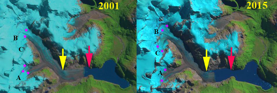
From REMA Landsat images from Feb. 2016 and Oct. 2019 indicating the front of the Cugnot Ice Piedmont (CP)  and Broad Valley (BV) ice fronts in Eyrie Bay.  Point A, B, and C indicate specific bedrock knobs near the ice front.  Point D is just south of a side glacier entering the bay.

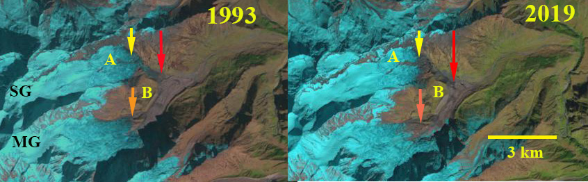
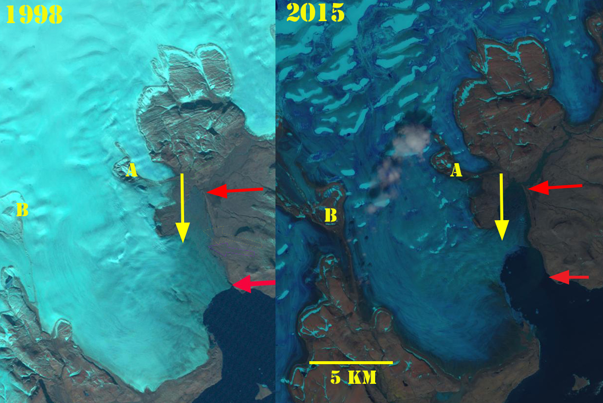
Eyrie Bay is near the tip of the Antarctic Peninsula and is rimmed by tidewater glaciers including the Cugnot Ice Piedmont.  The changes of the ice front fed by the Cugnot and from Broad Valley were mapped by Ferrigno et al (2008)   They noted a retreat from 1956-1977 averaging 36 m/year from 1977-1988 a retreat of 12 m/year, and 6 m/year from 1988-2000. Here we examine Landsat imagery from 2000-2020 to identify changes of the two glacier fronts. The continued significant warming air temperatures on the Antarctic Peninsula have increased surface ablation in the region (Barrand et al 2013), with 87% of glaciers around the Antarctic Peninsula now receding Davies et al (2012) . The most dramatic response has been the collapse of several ice shelves, Jones, Prince Gustav, Wordie, Larsen A and Larsen B. The  nearby Prince Gustav Ice Shelf connecting James Ross Island to the Trinity Peninsula collapsed after 1995 (Glasser et al 2011).

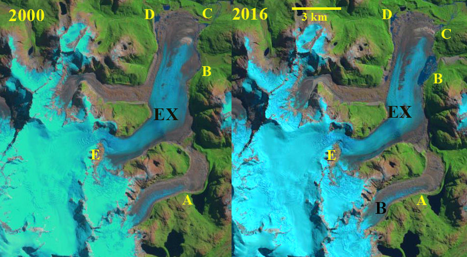
In 2000  the Broad Valley terminus (BV) extended 500 m beyond bedrock knob at Point A and 1400 m eastward beyond the bedrock knobPoint B. The Cugnot Ice Piedmont terminus (CP) extended from the northern tip of the bedrock knob at Point C. In 2016 the BV terminus in Eyrie Bay was 600 m east of the Point A bedrock knob and 1200 m east of the Point B bedrock knob.  By October 2019 the BV ice front had retreated to the bedrock knob at Point B and terminated near the western end of the bedrock knob at Point A, with just a narrow band of fringing ice around Point A. At Point C a small embayment has developed along the west margin of the CP terminus and the embayment near Point D has become wider and move concave.

The surface slope upglacier of the BV terminus rises quickly indicating a rising bedrock topography too, which should slow retreat in the near future.  The CP terminus has a gradual even slope suggesting there will be continued retreat. The retreat of glaciers in this region has been attributed to both atmospheric warming in the region driving surface melt increases , and in some cases increasing ocean temperatures and ice shelf bottom melting (Barrand et al 2013; Davies et al 2014).

Landsat images from 2000 and 2020 indicating the front of the Cugnot Piedmont (CP)  and Broad Valley (BV) ice fronts in Eyrie Bay.  Point A, B, and C indicate specific bedrock knobs near the ice front.  Point D is just south of a side glacier entering the bay.

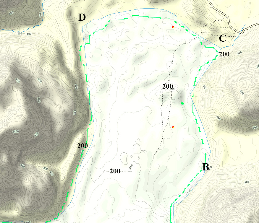
From REMA Antarctica contour of Broad Valley (BV) and  Cugnot Ice Piedmont (CP), contour interval is 25 m.

Scott Glacier, Alberta Retreat 1987-2019

Scott Glacier, Alberta in 1987 and 2019 Landsat images. Yellow arrow indicates the 2019 terminus location and Point A and B are areas of bedrock expansion amidst the glacier.

Scott Glacier is the largest outlet glacier of the Hooker Icefield the drains into the Whirpool River and then the Athabasca River.  The icefield straddles the BC/Alberta border. Jiskoot et al (2009) examined the behavior of the Clemenceau-Chaba Icefield, 25 km south finding that from the mid 1980’s to 2001 the Clemenceau Icefield glaciers lost 42 square kilometers, or 14% of their area. On Columbia Icefield 60 km to the southeast Tennant and Menounos (2013) found that from 1919-2009 glaciers had a mean retreat of 1150 m and mean thinning of 49 m for glaciers, with the fastest rate of loss from  2000-2009.

The Scott Glacier in 1987 had terminated at 1500 m, within 300 m of an alpine lake.  At Point A there is a convex aspect to the glacier as it passes over a subglacial knob.  The snowline is near this knob at 2200 m.  In 1998 there is limited retreat of the main terminus and Point A is still beneath the ice. The snowline is just above Point A at 2250 m. In 2014 the glacier has retreated to the base of a step at ~1800 m.  The snowline is well above Point A at 2450 m.  In 2019 the terminus has retreated 750 m since 1987.  Point A has emerged as a bedrock knob at the glacier surface.  At Point B a rock rib has widened since 1987 and extends further into the heart of the glacier. The snowline in 2019 is at 2400 m at the end of July.

Scott Glacier’s retreat is less extensive than other nearby glaciers such as Chaba Glacier ,  Cummins Glacier and  Columbia Glacier.

Scott Glacier, Alberta in 1998 and 2014 Landsat images. Yellow arrow indicates the 2019 terminus location and Point A and B are areas of bedrock expansion amidst the glacier.

Scott Glacier map indicating the glacier margins in the 1990’s.


Scott Glacier Digital Globe image indicating 1987 terminus location (red arrow) and 2019 terminus location yellow arrow. Point A is where bedrock is emerging and Point B is where the bedrock ridge is extending across glacier. Both Point A and B indicate bedrock steps that the glacier steepens as it flows over. The glacier remains crevassed to the front indicating no stagnant zone.


Reqiang and Jicongpu Glacier Retreat, Lake Expansion and Moraine Stability Increase

Reqiang Glacier (R) and Jicongpu Glacier (J) in 1993 and 2019 Landsat images.  M=Moraine, red arrow is the 1993 terminus location, yellow arrow the 2019 terminus location and purple dots the snowline.

Requiang Glacier, Tibet is just east of Shishapangma Mountain one of planets 14 peaks that exceed 8000 m and terminates in the rapidly expanding proglacial lake Gangxico at 5200 m. Jicongpu Glacier drains south from Shishapangma terminating in the proglacial lake Galongco at 5100 m. Both glaciers are fed by avalanching from the high slopes of  Shishapangma. Reqiang Glacier has been undergoing a rapid retreat since 1976, Li et al (2011) noted the retreat of 65.7 m/year from 1976-2006.  The retreat of this glacier fit the pattern of all 32 reported and was due to that increasing temperature. Zhang et al (2019)  observed that from 1974-2014 Galongco and Gangxico lakes expanded by ~500% (0.45 km2 /year) and ~107% (0.34 km/year.  As the lakes have expanded the wide moraines impounding the lakes have not experienced visible change. Here we examine the retreat of Reqiang and Jicongpu Glacier from 1993-2019 using Landsat imagery and the GLOF risk of Galongco and Gangxico.

Glacier lake outburst floods (GLOF) are a significant hazard in glaciated mountain ranges. The principal causes of GLOF are ice dam failure, moraine dam failure and/or avalanching into a lake.  Harrison et al (2018) noted there has been a decline in recent decades of GLOF events globally and in the Himalaya due to moraine dam failure.  In the Himalaya the main cause of moraine dam failure is ice avalanches into the lake. This decline has occurred during a period of rapid glacier retreat and the formation of many more alpine lakes. Hence, the number of locations where a potential GLOF could occur has increased, but the actual risk of any particular location generating a GLOF has declined even more.  Carrivick and Tweed (2016) observed that the number of GLOF’s due to all causes globally has declined since the mid 1990’s, and that this decline is not a reporting issue, since reporting has gotten better.  The main cause of the 1348 GLOF’s that they archived had been ice dam failure at 70%.  How has the retreat of Reqiang and Jicongpu Glacier impacted the risk of a GLOF?

In 1993 Reqiang Glacier terminated in a 3.1 km long Gangxico, which had an area of 2.9 km2.  The lowest 2.5 km of the glacier had a low slope and the snowline was above this at 5500 m.  Jicongpu Glacier terminated in a 2.8 km long Galongco with an area of 2.6 km2 and had a 3.5 km low slope debris covered terminus zone. By 2000 Reqiang Glacier had retreated 400 m and the low slope terminus tongue had a significant expansion of debris cover. Jicongpu Glacier had retreated 300-400 m.  By 2018 Reqiang Glacier had retreated 1900 m, the glacier snowline is only 1 km from the calving front at ~5500 m.  Jicongpu Glacier has retreated 2100 m on the east side and 1400 m on the western margin of the lake.  The debris covered area has been reduced to ~1 km2. From 1993-2019 Reqiang Glacier has retreated at a rate of ~95 m/year.  Gangxico  has expanded to an area of 4.6 km2 and is 5.0 km long. The snowline on Reqiang Glacier has been consistent in location in each of the years.  Jicongpu Glacier has retreated at an average rate of ~70 m/year.  Galongco has expanded to an area of 5.5 km2.

At Reqiang Glacier the moraine band impounding Gangxico is 1950 m wide and does not have visible signs of change.  With time since emplacement and retreat of the glacier into the lake the moraine will stabilize more.  Given the continued even if slow increased  moraine stability and the large moraines width the risk of dam failure is limited. At Jicongpu Glacier the moraine band is 1200 m wide impounding Galongco, again considerable.  These two glacier indicate the competing factors for GLOF risk, the size and stability of the moraine, versus the expanding volume of the lake.  Similarly a retreating glacier can reduce the ice avalanche hazard as the lake expands and ice slope diminish or the retreating glacier can provide access to steeper ice slope depending on the specific topography.  Zhang et al (2019) suggest both lakes have limited room to expand as they near a glacier surface slope increase.The retreat of these two glaciers follows that of many alpine glaciers in the region where lakes exist at the terminus which has enhanced retreat such as at Yanong Glacier and Drogpa Nagtsang Glacier.

Reqiang Glacier (R) and Jicongpu Glacier (J) in 2000 and 2018 Landsat images.  M=Moraine, red arrow is the 1993 terminus location, yellow arrow the 2019 terminus location and purple dots the snowline.

Gangxico Lake fed by Reqiang Glacier in Digital Globe image from 2015 indicating the moraine that impounds the lake with yellow arrows.

Galongco Lake fed by Jicongpu Glacier in Digital Globe image from 2015 indicating the moraine that impounds the lake with yellow arrows.


Exploradores Glacier Lake Development, Chile

Exploradores Glacier  (EX) in 1987 Landsat and 2020 Sentinel image.  Points A-E are consistent locations discussed.  B=Bayo Glacier.

Exploradores Glacier is an outlet glacier at the northeast corner fo the Northern Patagonia Icefield (NPI).  Glasser et al (2016) note the recent 100 m rise in snowline elevations for the NPI, which along with landslide transport explains the large increase in debris cover since 1987 on NPI from 168 km2 to 306 km2  On  Exploradores  Glacier debris cover expanded by 5.5 km2 from 1987-2015.   Loriaux and Casassa (2013) examined the expansion of lakes on the Northern Patagonia Ice Cap. From 1945 to 2011 lake area expanded 65%, 66 km2Davies and Glasser (2012) noted the fastest retreat during the 1870-2011 period was from 1975-1986 for Exploradores Glacier. Here we examine the response of the glacier to climate change from 1987 to 2020.

In 1987 Exploradores Glacier has a 12 km2 terminus lobe with a couple of small proglacial pond with a total area under 0.2 km2 near Point D.  The snowline is at 1400 m near Point E.  A small lake is impounded by a lateral moraine of Bayo Glacier at Point A.   In 2000 there is now a single small pond near Point D and a small proglacial pond 0.1 km2 near Point C.  The snowline is at  1400 m near Point E. In 2016 small fringing proglacial ponds exist near Point C and D.  A substantial proglacial lake has developed at Point B with an area of ~1 km2 on the east margin of the glacier.  The impounded lake at Point A has not changed. In 2020 the proglacial ponds have expanded at Point C and D.  At Point B the proglacial lake has expanded to ~1.4 km2.  The snowline is above Point E at 1500 m. At Point A the impounded lake has drained somewhat and is now at a lower lake level.  The lake breached the lateral moraine, which had been increasing in relief from the thinning Bayo Glacier.  The snowline on January 1, in the middle of the melt season is already above Point E at 1500 m. The debris cover has extended 5 km up the middle of the glacier from the terminus.

The terminus lobe of the Exploradores Glacier is now collapsing, this is a process that has already occurred at Steffen Glacier, San Quintin Glacier and Colonia Glacier.  The terminus lobe is relatively stagnant as indicated by the minimal surface slope.  The retreat has been slow compared to adjacent Fiero Glacier. The result will be a new substantial proglacial lake.

Exploradores Glacier  (EX) in 2000 and 2016 Landsat images.  Points A-E are consistent locations discussed.  B=Bayo Glacier.

GLIMS view of the terminus indicating the 200 m contour and Point B-D in same location as on images.


Fiero Glacier, Chile Retreat Lago Fiero Expansion

Fiero Glacier in 1987 Landsat and 2020 Sentinel images.  Red arrow indicates 1987 terminus location, yellow arrow 2020 terminus lcoation, and purple dots the snowline. Point A,B and C represent locations where bedrock has expanded.

Fiero Glacier is an outlet glacier draining the northeast quadrant of the Northern Patagonia Icefield (NPI) terminating in Lago Fiero. Loriaux and Casassa (2013) examined the expansion of lakes of the Northern Patagonia Ice Cap. From 1945 to 2011 lake area expanded 65%, 66 km2Davies and Glasser (2012) noted the fastest retreat during the 1870-2011 period was from 1975-1986 for Fiero Glacier.  They noted that Fiero Glacier proglacial lake had an area of 6.6 km2.  Glasser et al (2016) note the recent 100 m rise in snowline elevations for the NPI, which along with landslide transport explains the large increase in debris cover since 1987 on NPI including Fiero Galcier. Here we examine the response of the glacier to climate change from 1987 to 2020.

In 1987 the glacier terminated at a narrow point in the 4.2 km long Lago Fiero that has an area of 5.6 km2.  By 2001 the glacier had retreated 500 m and the transient snowline is at 1000 m.  At point A there is a narrow rock rib. at Point B there are isolated rock rib and knobs and at Point C the rock rib is limited.  In 2015 the lake has expanded to an area of 7.3 km2, and the debris cover has also expanded. The transient snowline is at 1200-1300 m.  In 2020 the lake has expanded to an area of 9.5 km2 and a length of 6.5 km.  The 2.3 km retreat has led to a near doubling in the area of the Lago Fiero, the retreat since 2011 is the fastest rate observed. At Point A the rock rib is now a prominent separation, at Point B and C the rock rib has become continuous much like at Point A. The snowline on January 1, 2020 is at 1200 m, midway through the melt season.  The glacier slope increases 500-1000 m from the current terminus near a surface elevation of 600 m, which could mark the expansion limit of Lago Fiero (see map below).

The retreat of this glacier is larger than that of Colonia Glacier and Pared Nord Glacier further south and Verde Glacier to the north of the NPI.  All the outlet glaciers of NPI have retreated significantly in the last 30 years most leading to expanding proglacial lakes (Loriaux and Casassa, 2913;  Pelto, 2017).

Fiero Glacier in 2001 and 2015 Landsat images.  Red arrow indicates 1987 terminus location, yellow arrow 2020 terminus lcoation, and purple dots the snowline. Point A,B and C represent locations where bedrock has expanded.

Terminus of Fiero Glacier from the Randolph Glacier Inventory in 2001 (Green) and 2011 (blue).  the 500 m, 600 m and 700 m contour are indicated.  Note the steeper slope near 600 m which likely is beyond the expansion limit of Lago Fiero. Base map from GLIMS

Sona and Meola Glacier Retreat Dhauliganga Basin, India

Sona Glacier (SG) and Meola Glacier (MG) in 1993 and 2019 Landsat images. Red arrow indicates 1993 terminus location of Sona Glacier and Yellow arrow the 2019 terminus location.  The orange arrow marks the 1993 downglacier limit of clean ice, below is debris covered ice.  Point A marks a small expanding rock outcrop amidst glacier. Point B marks north lateral moraine exposure of Meola Glacier.

The Dhauliganga River is in the Uttarakhand District, India and is fed by a significant number of large glaciers.  The glacier runoff is a significant contributor to streamflow for the Dhauliganga Power Station 280 MW run of river hydropower. The reservoir is only 1 km long.  Sattar et al (2019) examined glacier volume and velocity of 15 large glaciers in the basin and found a 6.9% loss in area from 1968-2016.  The velocity tends to be highest in the upper ablation zone and declines toward the debris covered terminus regions.  Here we utilize Landsat imagery from 1993-2019 to focus on two glaciers Sona and Meola Glacier that were previously joined in Survey of India map (NH-44-06).

In the map below Sona Glacier and Meola Glacier are joined near Point B. In 1993  and 1994 Sona Glacier descends a steep slope terminating at the red arrow a short distance from Meola Glacier.  At Point A the rock outcrop is minor.  At Point B the lateral moraine slope above the glacier surface is limited.  By 2016 Sona Glacier has retreated to the top of the steep slope.  The orange arrow indicates clean ice on Meola Glacier has retreated upwards. By 2019 Point A has expanded and is now a ridge separating the glacier into two terminus tongues.  Sona Glacier has retreated 1200 m from 1993-2019.  The retreat was enhanced by the steep slope that the thin terminus descended in 1993. At Point B the lateral moraine slope above the glacier surface is notably larger indicating Meola Glacier thinning. The debris cover/clean ice transition on Meola Glacier has moved 600 m upglacier.

The retreat of the Sona Glacier and expansion of debris cover indicate the expansion of ablation zones that is also seen at nearby  Khatling Glacier, Gangotri Glacier and Ratangrian Glacier.

Sona Glacier (SG) and Meola Glacier (MG) in 1994 and 2016 Landsat images. Red arrow indicates 1993 terminus location of Sona Glacier and Yellow arrow the 2019 terminus location.  The orange arrow marks the 1993 downglacier limit of clean ice, below is debris covered ice.  Point A marks a small expanding rock outcrop amidst glacier. Point B marks north lateral moraine exposure of Meola Glacier.

Map indicating Sona Glacier (SG) and Meola Glacier (MG) draining into the Dhauliganga.

Mount Everest Region Glaciers December 2019 Limited Accumulation Area

Mount Everest region snowline identified on Dec. 11, 2019 Landsat image (yellow dots).  Green dots indicate the terminus and pink arrows flow direction of specific glaciers: T=Trakarding, DN=Drogpa Nagtsang, M=Melung, BK=Bhote Koshi, S=Shalong, Y=Yanong, G=Gyabarg, YN=Yanong North, GY=Gyachung, J=Jiuda, R=Rongbuk, ER=East Rongbuk, I=Imja, L=Lhotse, M=Marala, K=Khumbu, N=Ngozumpa.

The winter monsoon for the Himalaya is a dry cold period with limited new snow accumulation.  The Landsat image of Dec. 11, 2019 highlights the snowline at 5500-6200 m on glaciers around Mount Everest.  This high of an elevation indicates the accumulation area of the glaciers is too small to sustain the current ablation areas. This is explored in detail below. King et al (2019) found during the 2000-2015 period Himalaya mass balance losses of debris-covered and clean-ice glaciers to be substantially the same, with mass balance loss for lake-terminating glaciers being significantly higher. The overall mean was −0.39  m/year.  Maurer et al (2019) found a doubling of the average rate of loss across the Himalaya during 2000–2016 relative to the 1975–2000 interval. King et al (2017) observed the mass balance of 32 glaciers in the Mount Everest area from 2000-2015 finding a mean mass balance of all glaciers was −0.52 m/year, increasing to -0.7 m/year for lake terminating glaciers. Brun et al (2017) identify a mean balance of -0.33 m/year for 2000-2016 in Eastern Nepal, similar to King et al (2019) and not the highest loss rate in the region. Dehecq et al (2018) examined velocity changes across High Mountain Asia from the 2000-2017 period identifying a widespread slow down in the region.  The key take away is warming temperatures lead to mass balance losses, which leads to a velocity slow down, and both will generate ongoing retreat.

For an alpine glacier to be in equilibrium requires at least 50% of its area to be in the accumulation zone, this is the accumulation area ratio (AAR).  On Dec. 11, 2019 the snowline indicates where the accumulation zone begins.  The elevation ranges from 5500 m on Melung Glacier to 6200 m East Rongbuk Jiuda and Gyabarg Glacier.  The area above the snowline, AAR, is less than 30% of the total glacier on: Trakarding, Drogpa Nagtsang, Melung, Bhote Koshi, Shalong, Yanong, Gyabarg,  Jiuda, Rongbuk, East Rongbuk, Imja, Lhotse, Marala Glacier.  Gyachung and North Yanong Glacier have an AAR between 30 and 40%. Khumbu and Ngozumpa Glacier have a high mean elevation and an AAR of close to 50%.

In 2015 and again in 2018 high winter snowlines indicated the same process in the Mount Everest region. See below the rise from Nov. 2017 to Feb. 2018 to similar elevation as seen in Dec. 2019. The high snowlines indicate an accumulation area that is too small to maintain these glaciers, which drives continued retreat, such as reported at Drogpa Nagtsang and Yanong Glaciers.

Dec. 11, 2019 snowline:

6200 m =East Rongbuk, Jiuda, and Gyabarg

6100 m = Gyachung,

5900 m= Rongbuk, Imja, Lhotse

5800 m=Trakarding, Melung, Yanong North

5700 m= Ngozumpa, Drogpa N., Yanong, Shalong, Bhute Khosi

5600 m= Marala, Khumbu

5500 m= Melung

Landsat images from Nov. 17 2017 and Feb. 10 2018 indicate a rise in the snowline, purple dots, on glaciers east of Mount Everest, indicating ablation even in winter from the terminus to the snowline. Rongbuk Glacier=R, East Rongbuk Glacier=ER Far East Rongbuk Glacier=F, Kada Glacier=K,  Barun Glacier=B,  Imja Glacier=I and Kangshung Glacier=KX.

Kerguelen Island Glacier Retreat Expands Lake District

Eastern Outlet glaciers of Cook Ice Cap in a 2001 Landsat and 2019 Sentinel image indicating retreat from 2001 terminus positions (red arrows) to 2019 terminus location (yellow arrows).

The east side of the Cook Ice Cap on Kerguelen Island outlet glaciers have retreated expanding and forming a new group of lakes (Pelto, 2016).  Here we examine the changes from 2001-2019 along using Landsat and Sentinel imagery. Retreat of glacier in the region was examined by Berthier et al (2009) and is exemplified by the retreat of Ampere Glacier.  Verfaillie et al (2016) examined the surface mass balance using MODIS data, field data, and models.  The accelerating glacier wastage on Kerguelen Island was observed do be due to reduced net accumulation and resulting rise in the transient snowline since the 1970s, when a significant warming began.  This has led to nunatak expansion on the ice cap.

In 2001 the northern outlet glacier terminates in a wide portion of the proglacial lake #1.  The central outlet, #2, has two terminus locations the northern is in a proglacial lake that is 2.5 km long and the southern arm terminates on land.  The southern outlet terminates on land.  By 2011 the northern outlet has retreated into a narrow section of the proglacial lake. The center terminus has retreated with a new lake forming in front of its southern arm. The southern outlet has retreated revealing a new developing lake.  In 2014 the northern terminus has retreated from the primary proglacial lake. The central terminus is producing icebergs from both arms. The lake continues to expand at the southern outlet.  The 2019 image is from early in the melt season. The northern terminus has retreated 1100 m since 2001 and is no longer calving in a substantial lake. The central terminus has retreated with the northern and southern arm retreated 1500-1800 m, with a new lake forming in front of the southern arm.  The southern outlet glacier has retreated the most, 2100 m since 2001, leading to the formation of a new lake of the same length. Outlet glaciers of the ice cap that are not calving are also retreating indicating that the retreat has been driven by rising snowline and enhanced by calving. The central and southern outlets continue to calve and should continue retreat more rapidly than the northern outlet.

Eastern Outlet glaciers of Cook Ice Cap in a 2011 and 2014 Landsat images indicating retreat from 2001 terminus positions (red arrows) to 2019 terminus location (yellow arrows).

Digital Globe image of the Cook Ice Cap, with the main outlet, Ampere Glacier and the three glaciers examined here 1-3.


Stave River, BC Run of River Hydropower Changes with Glacier Retreat

Stave Glacier area in 1992 and 2019 Landsat images illustrating the loss of glacier area.  Red arrows indicate 1992 terminus location, yellow arrow 2019 terminus location, Point 1-3 are proglacial lake that are evolving, P=Piluk Glacier and S=Stave Glacier.

Stave River drains into Stave Lake and has a 40 km length above the lake.  The basin has a glaciated area of 32 km2. The basin above Stave Lake has two Run of River Hydropower plants (RORH) .  The 17.5 MW RORH project on the Northwest Stave River was built by Innergex Resources and was opened in 2013. The facility is 18 km upstream of Stave Lake and has 1.9 km long diversion reach. The 33 MW RORH project on the Upper Stave River was built by Innergex Resources and was opened in 2011.  Stave River has a substantial fall run of Coho and Chum.  A decline in the salmon runs beginning in 2000 led to development of a Lower Stave river water use plan to reduce blockage at the Ruskin Dam hydropower site, which is not an RORH.  This has not led to a recovery of salmon, in fact the 2008-2012 population numbers are lower than prior [Ladell and Putt, 2015].  Stave River has a peak flow in June and mean July-September runoff is 37.4 m3s-1.

RORH lack significant reservoirs by definition and as a result cannot alter the discharge of a river or store water, including glacier runoff.  RORH divert a portion of a rivers discharge through the power system, reducing discharge for the diversion reach of the power system, before returning the water to the river. Mountainous nations with substantial hydropower potential and glaciers are expanding their use of RORH [Orlove, 2009].  The growth of RORH has been due to the lower cost of development and reduced environmental impact, which result from the absence of a large storage reservoir.

Peak streamflow in the alpine regions of the Pacific Northwest occur during the spring snow melt season. Glacier runoff peaks in the mid to late summer during the height of the ablation season, coincident with minimum streamflow of late summer and early fall.  The loss of glacier area from these watersheds thus reduces streamflow primarily during late summer minimum flow periods.  This has been observed in several Pacific Northwest basins where a decline of more than 20% in glacier area has led to a decrease in glacier runoff [Stahl and Moore, 2006; Pelto, 2011].  In such basins RORH will have a reduced seasonal production capacity.

Stave Glacier, the largest glacier in the watershed, declined from 11.38 km2 in 1988 to 9.45 km2 in 2005 [Koch et al 2009] and 8.6 km2 in 2019. The terminus retreated 1900 m during the 1992-2019 period.  Piluk Glacier terminated in a proglacial lake in 1992.  By 1998 it had retreated from this lake and by 2015 a new proglacial lake was forming at Point 2. The glacier retreated 800 m from 1992 to 2019, and the area was reduced from 3.5 km2 to 2.0 km2 . The glacier lost all of its snowcover in 2015, and more than 90%in 2016 and 2019, indicating it cannot survive current climate. Point 1 indicates where a glacier terminates in a proglacial lake in 1992 at what is more of a pass than a valley.  This is still the case in 1998, but in 2015 the lake is no longer proglacial and only 20% of the 1992 glacier remains. Point 3 in 1992 is a glacier filled basin that is narrowly attached to an adjacent glacier. In 1998 the glacier still fills the basin but is no longer attached to the adjacent glacier. By 2015 the basin is mainly a proglacial lake.  In 2019 only a small section of glacier remains at the southwest edge of the lake.  There are two other glaciers between Stave Glacier and Piluk Glacier that are unnamed where red arrows indicate the 1992 terminus location.  The northern flowing of these glaciers has retreated 850 m, while the south flowing glacier retreated 400 m.  In both cases this represents more than 30% of the total glacier length.

Stave River Basin, British Columbia indicating hydropower plants and glaciers in the basin (Map created by Ben Pelto)

Future Glacier Runoff and Hydropower Implications

Recent glacier runoff is determined from a mean observed regional summer balance of -2.9 m w.e.  Summer glacier runoff is 98.6 million m3, yielding a mean summer discharge of 7.5 m3s-1, which is 20 to 24% of total stream discharge.The rate of glacier area loss was 0.53%/year from 1985-2005 [Bolch et al 2010].  A continuation of this trend up to 2050 would yield a 24% area decline, with glacierized area in the basin of approximately 26 km2 in 2050.  Since 2005 the area loss has accelerated to ~1% /year.  This would lead to an area of  22.4 km2. A greater decline is likely however, as modeled warming of 2.2 ˚C by 2050 would lead to higher ablation rates [Clarke et al 2015].  Using the temperature index model and applying the increased temperature yields a mean summer balance of -3.5 m w.e., yielding 78.4 million m3.  This is equivalent to mean summer discharge of 5.9 m3s-1, a 20% decline from present glacier runoff. in 2050. The reduced glacier runoff will add to the earlier snowmelt runoff in the region through 2050 leading to significantly reduced late summer discharge and hydropower potential in the Stave River basin. Peak glacier runoff has passed and an ongoing decline will occur as is the case at many basins in the region including the Nooksack Basin in Washington (Pelto, 2015).

Stave Glacier area in 1998 and 2015 Landsat images illustrating the loss of glacier area.  Red arrows indicate 1992 terminus location, yellow arrow 2019 terminus location, Point 1-3 are proglacial lake that are evolving, P=Piluk Glacier and S=Stave Glacier.


Austre Torellbreen, Svalbard Retreat and Nunatak Expansion

Austre Torellbreen in 2000 and 2019 Landsat images.  Red arrow is the 2000 terminus location, yellow arrow the 2019 terminus location. Point 1,2 and 3 are nunatak areas that are expanding.

Austre Torellbreen is an outlet glacier on the southwest coast of Svalbard.  It is just west of calving glacier that are retreating such as Paierbreen and Samarinbreen and adjacent to the land terminating Nannbreen. Blaszczyk et al (2008) report the velocity of Austre Torellbreen near the calving front of 220-265 m/year. Nuth et al (2013) determined that the glacier area over the entire archipelago has decreased by an average of 80 km per year over the past 30 years, a 7% reduction.

In 2000 the calving front is 4.7 km wide and has a low slope at the terminus with the surface reaching 150 m 2.5 km from the calving front.  The calving front is at a point where the embayment widens upglacier and has outwash plains on either side of the margin. The snowline is at 300 m in 2000.  At Point 1 is an isolated nunatak and at Point 2 and 3 are limited ridges extending from nunataks. By 2014 the glaciers western margin has retreated into the widening embayment, with more limited retreat in the center and eastern margin of the glacier.  By 2019 the Austre Torellbreen western margin has retreated 2400 m, while the eastern margin has retreated 800 m. The terminus has narrowed to 4.2 km and is retreated from an area of low slope margins to a location between two peak Brattho and Raudfjellet. There is an area of extensive crevassing at the current calving front, suggesting that further calving retreat will occur. At Point 1 the nunatak has expanded in area and vertical relief. At Point 2 the ridge that was separated in two segments has joined into a single ridge.  At Point 3 the ridge has extended by 500 m and has a greater relief in 2019.  The nunataks and mountain ridges that are amidst and adjacent to Austre Torellbreen can be seen to emerge and expand from 2000 to 2019 as the glacier thins.  This thinning leads to the retreat that is enhanced by calving.


Austre Torellbreen in TopoSvalbard map from circa 2000 and in a visual image from 2014.

Austre Torllbreen in 2014 Landsat image. Red dots indicate the snowline at 350 m.

Wright Glacier, Alaska Snowline and Terminus Retreat

Wright Glacier in 1984 and 2019 Landsat images.  The red arrow indicates 1984 terminus location, yellow arrow 2019 terminus location, pink arrow where the surface slope steepens and red dots indicate the snowline. 

Wright Glacier is the largest glacier draining an icefield just south of the Taku River and the larger Juneau Icefield. The glacier accumulation zone is mainly in British Columbia.  The glacier filled a lake basin in 1948 as illustrated by the USGS map and  NSIDC collection,  though the terminus is beginning to break up.

In 1984 the glacier ended at a peninsula in the lake where the lake turns east.  This was my view of this glacier during the summers of 1981-1984 from the Juneau Icefield with the Juneau Icefield Research Program. Our bad weather came from that direction so keeping an eye on that region during intervals between weather events was the practice. Here we examine Landsat imagery from 1984-2019 to document the retreat of Wright Glacier and the rise in elevation of the snowline.

In 1984 the lake had a length of 3.1 km extending northwest from the glacier terminus. The snowline in mid-August with a month left in the melt season was at 1150 m at a main glacier junction.  By 1993 the glacier had retreated little on the north side of the lake and 200 m on the south side. The snowline in mid-September close to the end of the melt season was at 1150 m. By 2013 the glacier had retreated 900 m and was terminating in a narrower portion of the expanding lake, 30 m/year. The snowline was again at the main junction near 1150 m. In 2018 the snowline on September 16th was at 1450 m with less than 25% of the glacier in the accumulation zone.  In 2019 on Aug. 2 the snowline was at 1500 m, likely the highest snowline in the last 70 years, as was the case at nearby Taku Glacier. The high snowlines of recent years has driven an acceleration of the retreat of 1000 m since 2013, 150+ m/year. The glacier has a steeper surface slope 2 km beyond the current terminus front indicating the lake ends either near this point, pink arrow.  This could lead to a reduction in the retreat rate, though calving has not been a major factor in retreat of this glacier.

The glacier drains the same icefield as the retreating West Speel and Speel Glacier.

Wright Glacier in 1993 and 2018 Landsat images.  The red arrow indicates 1984 terminus location, yellow arrow 2019 terminus location, pink arrow where the surface slope steepens and red dots indicate the snowline.

Wright Glacier in 2013 Landsat images and USGS Topo imagery.  The red arrow indicates 1984 terminus location, yellow arrow 2019 terminus location, pink arrow where the surface slope steepens and red dots indicate the snowline.

Kropotkina, Novaya Zemlya Retreat Opens 12 km2 Embayment 1988-2019

Kropotkina Glacier, Novaya Zemlya in 1988 and 2019 Landsat images. Red arrow marks the 1988 terminus location and yellow arrow the 2019 terminus location.  Point A and B mark nunataks in 1988.

Kropotkina Glacier is a tidewater glacier on the southeast coast of Novaya Zemlya that drain into Vlaseva Bay.  The glaciers terminate in the Kara Sea and has been retreating like all tidewater glaciers in Novaya Zemlya LEGOS, 2006 .  The map shown below from this project indicates the lack of an embayment in 1952, red dashed line and limited retreat from 1952-1988. Carr et al (2014) identified an average retreat rate of 52 meters/year for tidewater glaciers on Novaya Zemlya from 1992 to 2010 and 5 meters/year for land terminating glaciers.  Carr et al (2017) found that between 2000 and 2013, retreat rates were significantly higher on marine-terminating outlet glaciers than during the previous 27 years. Here we examine Landsat imagery from 1988 to 2019 to identify changes in Kropotkina Glacier.

In 1988 the southern terminus is at the red arrow indicating a peninsula on the east side of the terminus, while the northern terminus is at the margin of a proglacial lake. Point A and B are nunataks. In 1998 the southern terminus has not changed significantly.  The northern terminus has not retreated significantly, but the proglacial lake has drained. By 2015 the terminus tongue in the embayment has largely collapsed, though a tongue of ice reaches across this embayment. An area of more 7 km2 has gone from glacier ice to embayment since 1998. Point A is no longer a nunatak as marginal retreat has reached this point.  The snowline in 2015 is also higher than is typically observed extending beyond the image area and is above 800 m.

By 2019 the main embayment is free of ice, having expanded by 12 km2, as the result of terminus retreat. The terminus is now oriented north-south with a 6 km long calving front. The 2019 snowline is at 750 m.Point B remains a nunatak, but not for long with the continued high snowlines seen in 2015, 2018 and 2019. The retreat has mainly been via calving, and with an expanding calving front and reduced pinning points along the margin, the rapid retreat and area loss is not over.  How deep the water is at the calving front will determine how limited calving will be going forward.  The retreat of this glacier is substantial as has been the norm for tidewater glaciers such as Inostrantseva Glacier, Vera Glacier,  Mack and Velkena Glacier or Chernysheva Glacier, with the formation of new islands and glacier separation common place Pelto (2017)  and GlacierHub.

Kropotkina Glacier, Novaya Zemlya in 1998 and 2015 Landsat images. Red arrow marks the 1988 terminus location and yellow arrow the 2019 terminus location.  Point A and B mark nunataks in 1988.

kropots map

Map of the region from  LEGOS, 2006 with elevations indicated.