Zhizhai Glacier Retreat, Lake Expansion, China

zhishai compare

Fig. H. Zhizhai Glacier change from 1991 to 2015, red arrow indicates 1991 terminus, yellow arrow 2015 terminus and purple arrow indicates areas of thinning. Green arrow indicates another lake growing with glacier retreat.

Located between Longbashaba Glacier and Jimi Glacier, this glacier extends 4.75 km north from the Nepal-China border in the southeast region of the Pumqu River basin.  The moraine dammed glacier lake, Zhuxico Lake, poses some risk to the 23 villages downstream of the lake and the Rongkong Hydropower station. This risk has been examined for another lake in the basin Longashaba by Yao et al (2012). Che et al (2014) report on an inventory of glaciers and glacier lakes in the Pumqu Basin, and note that lake expansion is higher from 2001-2013 than for the 1970-2000 period, posing greater threats for a glacier lake outburst flood. They report that there are 254 glaciers lakes in the basin currently 55 of which have formed since 1970. In 1991 the glacier terminated in a proglacial lake that was 2.25 km long. A tributary flowed around a ridge and rejoined the main glacier, purple arrow.   By 2000 the glacier had retreated 200 m, the tributary at the purple arrow remains connected to the main glacier.  By 2015 the glacier had retreated 600 m and the lake is 2.9 km long and remains 300 m wide.  The tributary at the purple arrow no longer rejoins the main glacier. Just east of Zhizhai Glacier an unnamed glacier also features an expanding lake due to glacier retreat (green arrow).  The retreat follows the pattern of other glaciers in the region that are retreating and having glacier moraine dammed lakes expanding such as Longbashaba Glacier and Lhonak Glacier.

zhizhai glacier 2000

Landsat image 2000

zhizhai 2014

Google Earth Image indicating the flow of the glacier, blue arrows and areas of upglacier thinning, purple arrows. 

1991 to 2015 Comparison
zhizhai change

Blágnípujökull, Iceland Retreat 1986-2015

blagni compare

Blágnípujökull comparison in Landsat imagery from 1986 and 2014. 

Blágnípujökull is an outlet glacier on the western side of Hofsjökull. The Iceland Glaciological Society spearheads an annual terminus monitoring program led by Oddur Sigurðsson. This data set enabled an examination of glacier response to climate change in Iceland from 1930-1995 by Tómas Jóhannesson, Icelandic Meteorological Office and Sigurðsson (1998). This illustrated that Hofsjökull glaciers retreated little from 1950 to 1990, but all retreating significantly after 2000. Here we examine Landsat imagery of Blágnípujökull terminus change from 1986 to 2015.

blagnipujokull map
Outlet map of the glacier from the Iceland Glaciological Society.

iceland retreat
Iceland Glaciological Society data on terminus change, notice change from advance to retreat in the 1990’s

In 1986 the glacier terminated at the red arrow. North of the main terminus is a separate glacier terminus, purple arrow. By 1998 there is limited retreat less than 200 m. By 2014 the terminus area around the purple area has been largely lost. The glacier has retreated from the red dots to the yellow dots, a distance of 600 meters. The thinning is also evident in the region between the two main termini of Blágnípujökull, the margin is not as close to the edge of the lava flow capping the hill that the glacier terminus parts around. The snowline is also quite high on the ice cap in 2014. In 2015 the image is after a summer snowstorm and the is not clear enough to accurately assess further terminus change. The changes in this glacier parallel those of other Iceland Glaciers: Porisjokull and Langjokull.

blagnipujokull 1986
1986 Landsat Image

blagnipujokull 1998
1998 Landsat Image

blagnipujokull 2014
2014 Landsat Image

blagnipujokull ge
Google Earth image

blagnipujokull 2015
2015 Landsat Image

Kronebreen and Kongsvegen, Svalbard Initiation of Glacier Separation 2015

kronebreen terminus2
Kronebreen terminus in 2013 (left) and 2015 (right), note the configuration change and separation initiation of Kronebreen and Kongsvegen at yellow arrow.
Kronebreen is a large, (450 km2) tidewater glacier on the northwest coast of Svalbard terminating in a shared terminus with Kongsvegen at the head of Kongsfjorden.  Changes in 2015 indicate the shared terminus will not continue.  Luckman et al (2015) observed Kronebreen has a winter speed of 1.5–2 m/day, with summer peaks of 3–4 m/day associated with positive air temperatures and periods of high rainfall.  The terminus of the glacier was relatively stable from 1990 to 2001 with even a slight advance at the end of that period (Trusel et al, 2010).  The fjord lacks a significant sill at its mouth resulting in significant connectivity with water masses of the West Spitsbergen Shelf, including Atlantic Water  Trusel et al, 2010). This aspect during summer can aid in frontal ablation and terminus retreat as noted in Figure 2a from Luckman et al (2015). Shellenberger et al (2014) observed that the period of Kronebreen stability ended in 2007 and that the glacier retreated 850 m and lost 2.1 square kilometers from 2007-2013. Long term they observed that the ablation loss of the terminus reach increased from 0.14 Gt per year from 1960-1990, to 0.20 Gt per year from 1990-2007 and was 0.21 Gt per year in 2013. The University Centre in Svalbard has established a set of cameras for time lapse work at the terminus, which is fortuitous given the changes that have occurred recently. In 2015 returning in the spring University Centre in Svalbard researchers noted the thinning and stretching of the terminus reach: Doug Benn, Penelope How, Heidi Sevestre and Nick Hulton. Penelope How examines the deployment of the cameras in 2015. Here we examine Landsat images to provide a snapshot of the changes that the above researchers have examined in detail.konebreen map
Map of Glacier front from TopoSvalbard.
In 1987 the joined front terminated near the western tip of Colletthogda, red arrow. The purple arrows indicate locations for comparison to 2015 of glacier thinning. By 1998 there has been a small retreat, that will be erased by a small advance the following years. I 2011 the front remains a single linear front, the greater level of crevassing of Kronebreen is evident as well as the shallower water on the southern margin of the fjord the Kongsvegen terminus. In 2013 a larger retreat has begun, the calving front is concave with more retreat on the southern, Kongsvegen side of the terminus. In 2015 substantial changes have occurred. The front of Kronebreen has retreated 1200 m on the northern margin since 1998 and 1500 m on the southern lateral moraine, this is 300-500 m since 2013. The most striking element is the right angle turn in the calving front at the lateral moraine with Kongsvegen. This is not a stable configuration. This represents the initiation of the separation of Kronebreen and Kongsvegen. The weakness along which the process is taking place is the lateral moraine. Kronebreen terminates in deeper water and can retreat more rapidly via calving. This retreat has been driven by enhanced ablation both at the surface and by the ocean. The higher velocity of Kronebreen is clear in the video of the glacier from the University Center of Svalbard. The process of separatiion is a trend in Svalbard note Samarinbreen.and Vasilievbreen.kronebreen 1987
1987 Landsat image

kronbreen 1998
1998 Landsat image
kronebreen terminus ge 2014
2011 Image from TopoSvalbard, note the differenence in level of calving between Kronebreen and Kongsvegen.

kronebreen 2013
2013 Landsat image

kronebreen 2015
2015 Landsat image

Engabreen Glacier, Norway Retreat

Engabreen is an outlet glacier of the Svartisen ice cap in northern Norway. It has an area of 40 km2. Most of the area lies between 1200 and 1450 m the high plateau of the ice cap. This glacier has been the focus of attention from the Norwegian Water Resources and Energy Directorate (NVE) for over 50 years. 

engabreen ge

Google Earth image of Engabreen Glacier, 2014. 

NVE maintains the most extensive and detailed glacier monitoring network in The NVE annual mass balance measurements on Engabreen indicate that winter snow typically accumulate 3 m of water equivalent on the ice cap. This amounts to 5-7 m of snowpack as the melt season begins in May. The glacier terminus descends from the ice cap down nearly to Svartisvatnet, a lake at 7 m. At the terminus annual melting is 12 m. The rivers from the northern and eastern side of Svartisen were regulated in the 1990’s for hydro power production by construction of a tunnel system partly underneath the glacier. Today about 60% of the potential runoff of the Engabreen is captured and sent through a bedrock tunnel to the hydropower facility. During completion of this tunnel access to the glacier base was opened. Today there is the world’s only ongoing subglacial laboratory here The melt water from Engabreen is collected into this tunnel system at 620 m a.s.l. underneath 200 m of glacier ice in the ice fall.  The sub-glacial blog has further details of this mainly winter research location

Late in the 18th century Svartisvatnet,the lake below the terminus, started to appear as the glacier retreated upvalley. In 1903 regular length change observations were initiated, a small advance ensued until 1910. By 1931 the glacier retreated 100 meters, and the glacier tongue was thinning. During the next decade calving led to rapid retreat revealing the rest of Engabrevatnet. This period of  retreat ended in 1965, Engabreen  advanced with three different pulses ending in 1971, 1984 and 1999, the last pulse reaching to within a few meters of the lake shore.Below are pictures from the NVE taken in 2000 and 2008 of Engabreen, note the large contraction of the terminus area.   This is further illustrated in Landsat images below. engabreen 2000-2008

NVE images of Engabreen Glacier

From 1990 the glacier ended at the red arrow before advancing by 1999 to the purple arrow.  Retreat followed to the yellow arrow in 2015, this is a 350 m retreat.  From 1999-2013 NVE amual terminus assessment indicates a retreat of 317 m.. At the green arrow the width of the glacier declined from 475 m in 1999 to 325 m in 2015.  At the orange arrows thinning is evident higher on the glacier as bedrock areas have expanded.  The snowline in 2014 is above these areas and is at all but one in 2015. This thinning suggest retreat will continue. The 2015 position is its point of furthest retreat since the Little Ice Age. The recent retreat indicates a recent trend of negative mass balance on the glacier. There is excellent flow off the ice cap that has persistent and consistent snowcover indicating this glacier will survive current climate.  This is also leading to the retreat of Storglombreen  and Flatisen from the same ice cap

engabreen 1990

1990 Landsat image

engabreen 1999

1999 Landsat image

engabreen 2014

2014 Landsat Image

engabreen 2015

2015 Landsat image


Colonia Glacier, Chile Retreat and Periodic Lake Outbursts


colonia-compare-1024x495

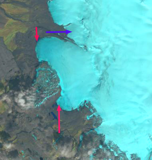
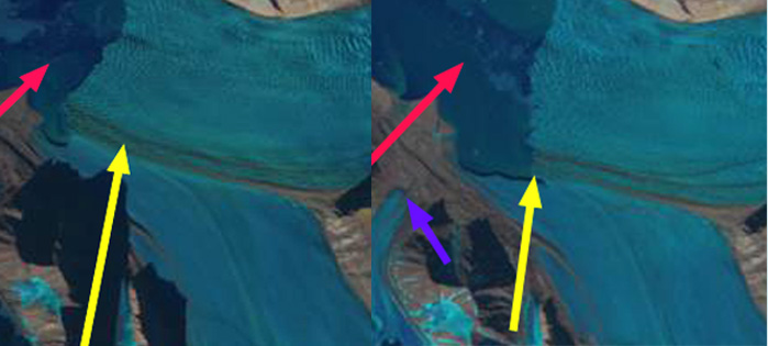
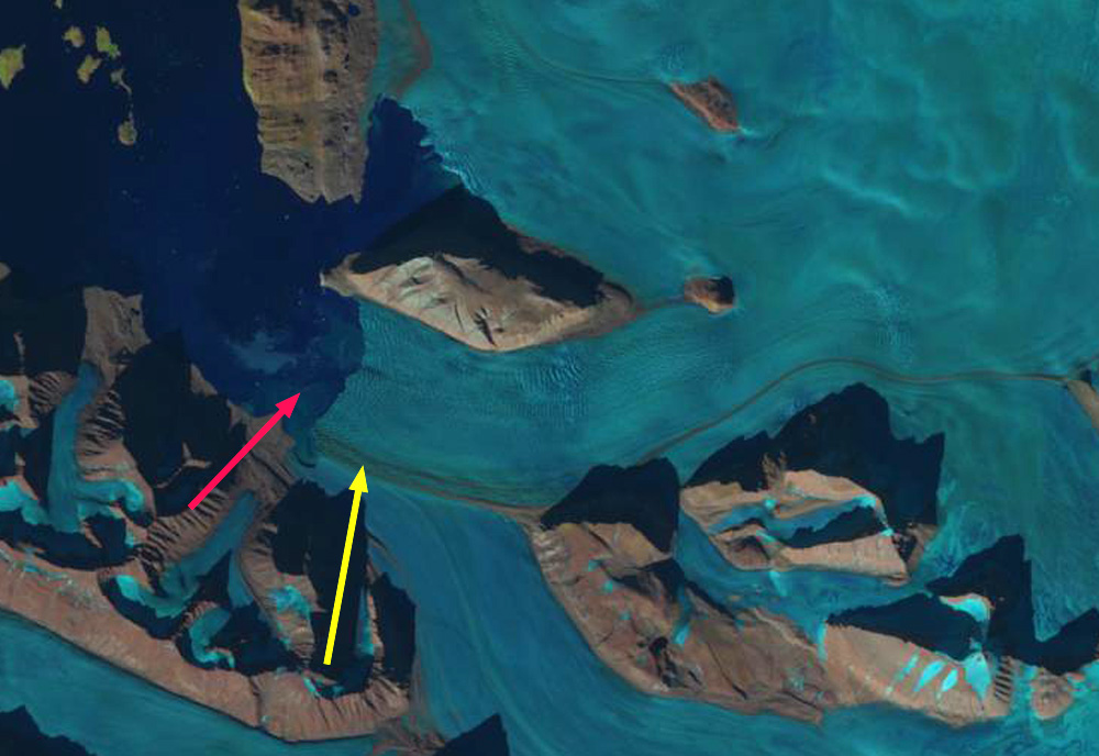
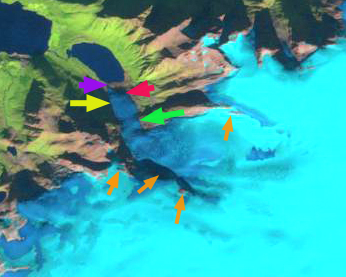
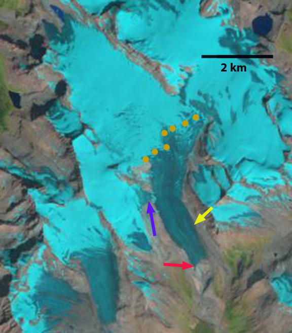
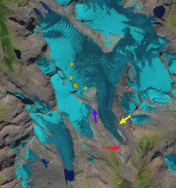
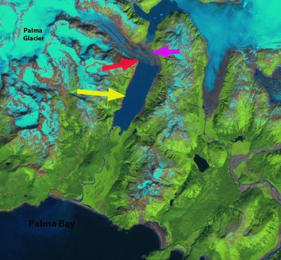
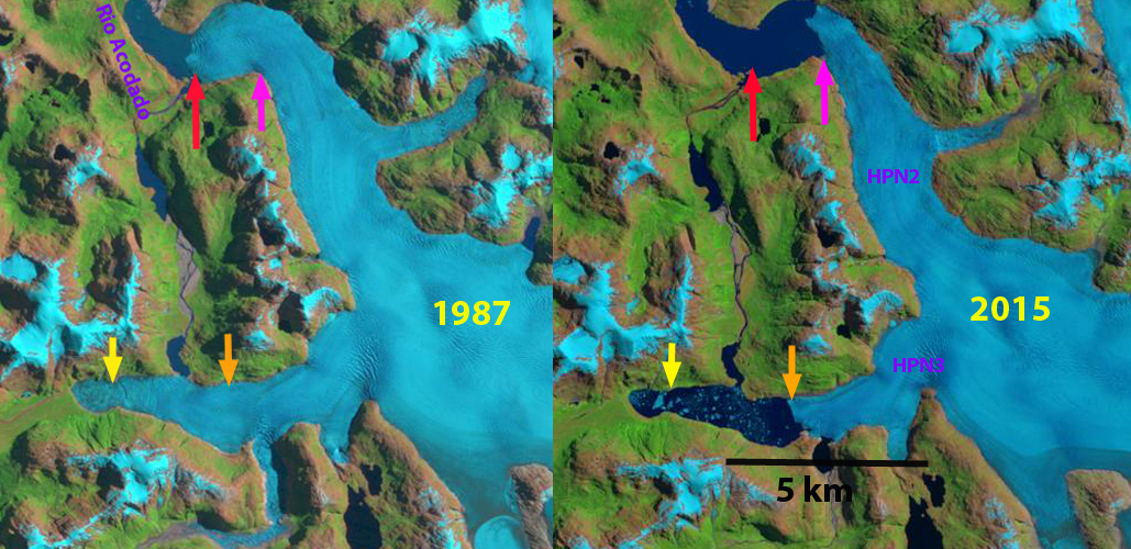
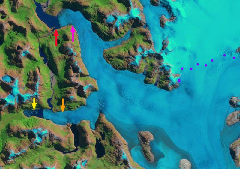
Comparison of 1987 and 2015 Landsat images indicating retreat from red arrows to yellow arrows of 2.5 km and development of a new lake at the terminus. orange arrow indicates glacier dammed lake that fills and empties periodically. 

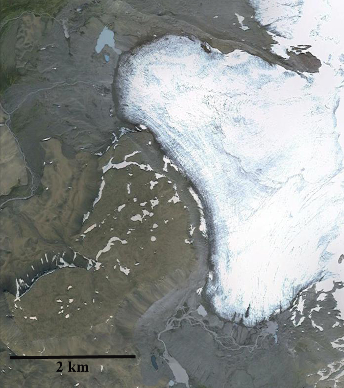
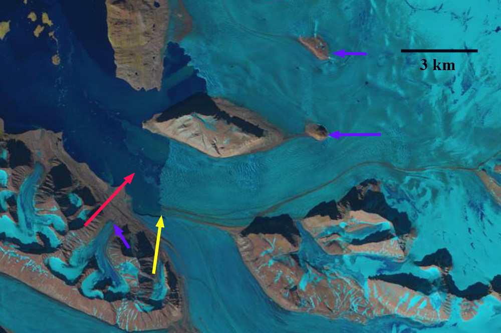
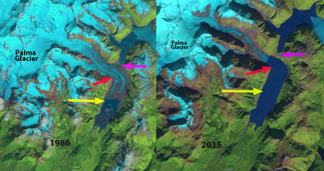
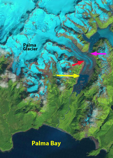
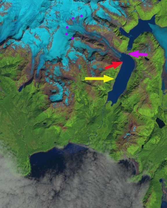
Colonia Glacier drains east from the Northern Patagonia Icefield feeding the Baker River, Chile. It is the largest glacier draining east from the NPI.  A comparison of the 1987  and 2015 images indicate a 2.5 km retreat of the glacier front, development of a large lake and areas of thinning well upglacier at the purple arrows. The recent substantial retreat of Colonia Glacier like Glacier Nef just to its north is posing new hazards. The glacier is unusual in the number of lakes that are adjacent to or feed into the adjacent glacier dammed or proglacial lakes. In the image below Lake A=Arco Lake, Lake B=East Terminal Lake, Lake C=Cachet 1 , Lake D= West terminal Lake, Lake E=Colonia Lake and Lake F=Cachet 2. In the case of Baker River the outburst floods are a threat to the planned hydropower developments as documented by Dusaillant and others (2009).  Hidroaysen Project proposed 5 dams on the Baker and Pascua River generating 2750 MW of power that after initial permit approval in 2011Chile’s Committee of Ministers overturned the environmental permits in 2015.

Slide1

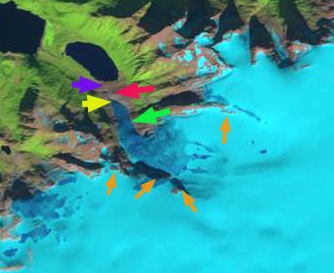
Google Earth image from 2005.

The glaciers recent retreat and glacier lake outburst floods have been closely monitored by the Laboratorio de Glaciología in Valdivia, Chile.  Aniya and others (1999) observed that Colonia Glacier began a rapid retreat after 1985 from 1997-2005 that has further accelerated, with a general frontal retreat of 2 km. Rivera and others (2007) observed that the Colonia Glacier had lost 9.1 square kilometers of area from 1979-2001, which is 3% of the total glacier area and thinned 1.1 m per year in the ablation zone.

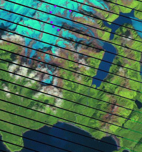
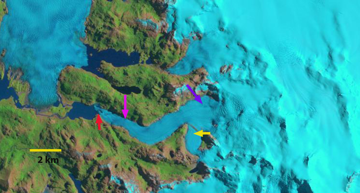
Image from Laboratorio de Glaciologia, frontal change 1944-2005.

The Laboratorio de Glaciologia’s observed in the spring of 2008 Baker River suddenly tripled in size, in less than 48 hours, roads, bridges, and farms were severely damaged. Lake Cachet 2 had vanished the 5 square kilometer glacial lake had emptied 200 million cubic meters of water in just a matter of hours. This lake drained beneath the glacier after sufficient water had filled the lake to buoy part of the glacier and subglacial conduits had begun to develop. Since Cachet 2 emptied in April 2008, the lake has emptied at least six more times October, December 2008, March and September 2009, March 2010, and early 2013 with peak flows released of 3000 cubic meters per second. Below are images of Cachet 2 full iand empty in 2008 from Laboratorio de Glaciologia’s. Also a  comparison of before and after drainage in Landsat images from Sept. 2012 and Feb. 2013.

cachet 2 empty

Cachhet Lake full looking toward Colonia Dam 2008

Cachet Lake after emptying looking upvalley away from Colonia Glacier 2008. 

colonia outburst 2013

Cachet lake full in Sept. 2012 and emptied in Feb. 2013 Landsat images.

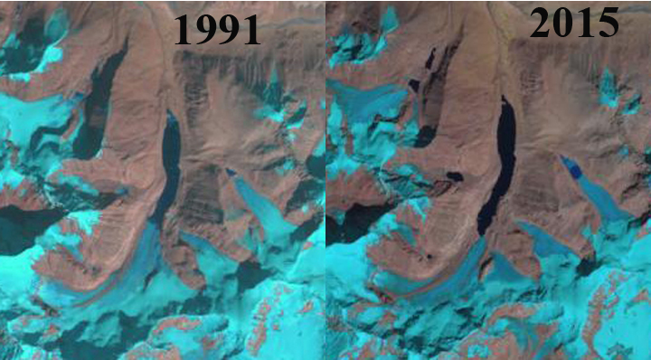
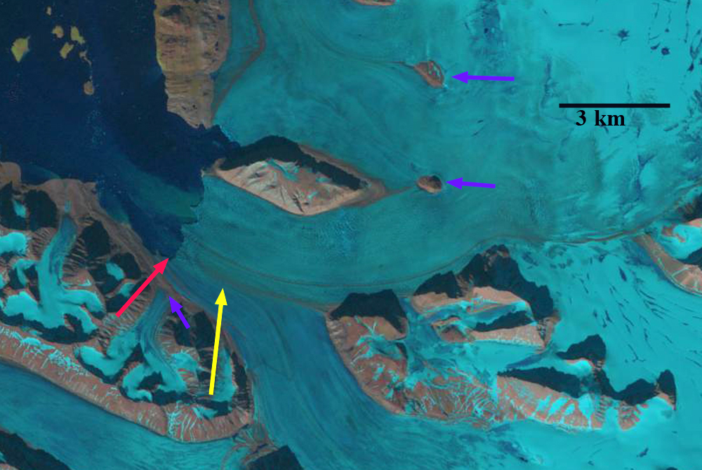
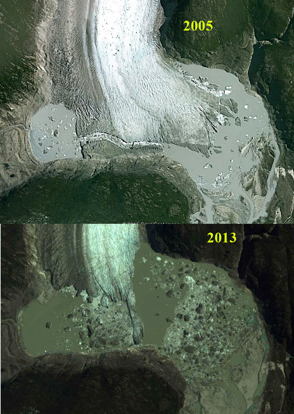
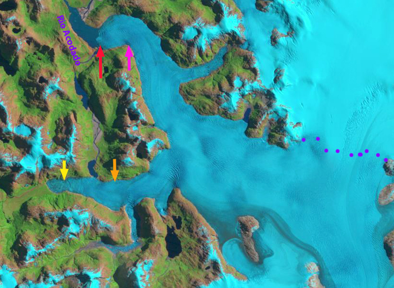
The two lakes at the terminus of the glacier did not exist in 1979, the western most terminus lake drained into the easternmost terminus lake (D) via a sub-glacial tunnel after formation in the late 1980’s until 2005 when a channel was cut right through the glacier terminus. Retreat of the glacier terminus first led to significant lake development in 2001.  This is evident in the image below, there is still glacier ice on both sides of this drainage channel.  By 2015 the lakes have merged into a single large proglacial lake at the terminus that is 3.2 km wide.The development and demise of glacier dammed lakes and the resultant problem of glacier lake outburst floods is not rare today, Imja Glacier, and Tulsequah Glacier are other examples.

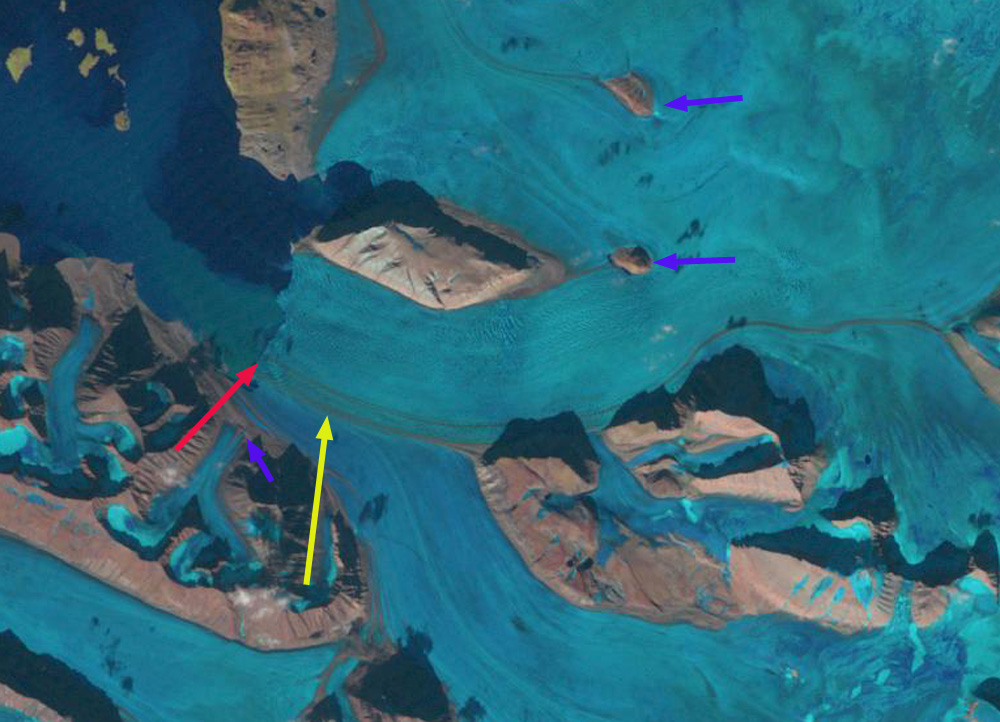
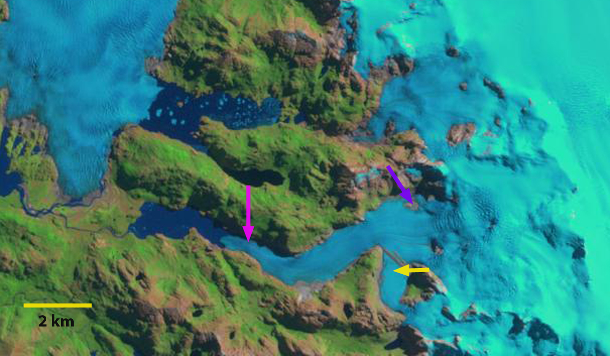
Lake expansion at the end of the Colonia Glacier from 2005 to 2013, Google Earth images. 

colonia terminus lake

Yoho Glacier, British Columbia Accumulation Zone Woes

yoho glacier melt

Yoho Glacier in 2005 no accumulation zone in sight.

Yoho Glacier is the largest southern outflow draining the south from the Wapta Icefield in the Kootenay region of British Columbia. It flows 6.5 km from the 3125 m to a terminus at 2200 m. The glacier terminus reach is thin, gently sloping  and uncrevassed poised for continued retreat. An exploration of Mount Balfour in 1898 a party led by Professor Jean Habel with the packer Ralph Edwards as a guide were the first to visit and describe Yoho Glacier. There descriptions of the magnificent Takakkaw Falls down river of the glacier quickly led to it becoming a frequent destination of visitors. The glacier was also accessible. Retreat up a steep slope at 2000 m made actually visiting the glacier difficult in the middle of the 20th century.  The glacier has retreated 2.1 km in the last century leaving a vast area of bare terrain, dotted by several small new alpine lakes. Here we examine changes in the glacier from 1986 to 2015 with Landsat imagery.

yoho map final
CanadianTopographic map

In 1986 the glacier terminated in a broad 500 m wide glacier terminus at 2150 m, red arrow, the glacier tongue remained wide up to the yellow arrow, 800 m. A tributary connected to the glacier at the purple arrow, and the glacier snowline, orange dots was at 2550 m. In 1998 the terminus had not retreated significantly, but had narrowed noticably. The tributary at the purple arrow was no longer connected and the snowline was at 2750 m, leaving little of the glacier snowcovered, which equates to a significant mass loss. In 2013 the snowline again was high at 2700 m. In 2015 the glacier terminus has retreated 300 m since 1986 and is only 250 m wide. The width at the yellow arrow is 450 m. The width reduction is an indicator of how much the glacier has thinned. The snowline is at 2800 m in this mid-August image, clinging only to the high slopes of Mount Collie, and would still rise for several more weeks in the summer. The nearby Peyto Glacier has an annual mass balance record indicating a thinning of 25 m during this period (Kerhl et al, 2014).  A glacier typically needs more than 50% of its area to be in the accumulation zone at the end of the summer to be in equilibrium.  In recent years when the snowline exceeds 2700 m less than 10% of the Yoho Glacier is in the accumulation zone. If the snowline is as high as it has been recently on Yoho Glacier, that indicates the lack of a significant accumulation zone and it cannot survive even current climate.  However, in both cases the Peyto and Yoho Glacier are rapidly losing volume, but remain substantial in size and are not on the verge of disappearing in the next few decades. The retreat is similar to that of Des Poilus Glacier shown in the lower left of the Landsat images here.

yoho glacier 1986
1986 Landsat Image

yoho glacier 1998
1998 Landsat Image

yoho glacier 2013
2013 Landsat image
yoho glacier 2015
2015 Landsat image

Fingers Glacier, Alaska loses a finger to melting

finger compare
Landsat comparison of terminus area of Fingers Glacier 1986 and 2015

Fingers Glacier flows from the southern end of the Fairweather Range to the coastal plain, where is expands into a segmented piedmont lobe. The southernmost finger is heavily debris covered. In the Mount Fairweather B-4 quadrangle USGS map based on 1951 aerial photographs the glacier has four prominent fingers each eroding its own basin.  Here we examine Landsat imagery to illustrate the changes in this glacier from 1951 to 2015.  From 1950-1980  glacier’s just to the north In Lituya Bay were advancing. The La Perouse Glacier its immediate neighbor to the north was stable. Palma Glacier directly to the southeast has retreated throughout the 1950-2015 period.  Larsen et al (2015) identify that from 1994-2013 this region of Alaska is a significant source of glacier volume loss and hence contributor to sea level rise.  The loss of 75 gigatons per year from glaciers in southern Alaska was determined in this study to be largely from surface melt not from calving losses.  The mass balance of both Taku and Lemon Creek Glacier of the Juneau Icefield have had a notable decline in mean mass balance from 1986-2015 versus the 1951-28985 period (Pelto et al, 2013).  The nearby Brady Glacier also experience a higher snowline (Pelto et al, 2013b) which led to volume losses quantified by Larsen et al (2015).
fingers map

USGS map based on 1951 images

By 1986 the glacier still had four fingers with retreat from the 1951 position yellow arrow to the 1986 position red arrows.  Retreat was 900 m for the first finger, 400 m for the second finger, 300 meters for the third and 400 meters for the fourth southernmost finger.   A new lake had developed at the second finger, well lake expansion occurred at the first and third finger.  By 1999 a lake is beginning to form at the fourth finger.  In 2015 the first finger has retreated 600 meters in 30 years.  The second finger has disappeared after a 700 m retreat from 1986-2015..  The third finger has lost half of its length to the expanding lake, a retreat of 600 m in 30 years.  The fourth finger which is the most debris covered, leading to slower thinning, has retreated 600 meters since 1986, with a lake at the terminus that is continuing to expand.

fingers 1986

1986 Landsat Image

fingers 1999

1999 Landsat Image

fingers 2015

2015 Landsat Image
fingers glacier

Google Earth Image indicating flowlines.

Palma Glacier, Alaska Retreat Opens Lake Passage

Palma Compare
An August 1986 and September 2015 Landsat Image of Palma Glacier, 1986 terminus yellow arrow.
Palma Glacier is an unnamed glacier just west of Brady Glacier and Glacier Bay that is the principal glacier draining into Palma Bay.  Here we examined the changes in this glacier from 1986 to 2015 with Landsat Imagery.  The glacier has terminated in a lake at the head of a river draining into Palma Bay at least since the 1950 USGS map was prepared.The neighboring Brady Glacier advanced for much of the 20th century,  its tributary lobes began to retreat after 1970.  The main Brady Glacier terminus did not begin to retreat until 2009 and is poised to begin a rapid retreat as lake development at the terminus continues due to ongoing thinning (Pelto et al, 2013)..

palma glacier ge

Google Earth image of the Palma Bay and Palma Glacier region

In 1986 Palma glacier flowed south out of the mountains before turning sharply west for 2 km before terminating in a lake at the yellow arrow. The lake had considerable debris covered ice bergs that had recently calved. By 1999 the glacier had retreated to the westward turn, red arrow, but did extend to the south side of the lake.  By 2014 the glacier had retreated from the westward turn, red arrow, and the strip of land between the two lakes at the purple arrow has been exposed and vegetated. it is now possible to paddle up one lake and portage to the next. The snowline purple dots is at 1000 m.  In 2015 this September image at top is after an early season snowfall, the last image below is an August image indicating the snowline is again at 1000 m with several weeks left in the melt season.  The glacier has retreated 2100 meters from 1986 to 2015 and still terminates in the lake. The retreat has slowed since 1999 after the lake narrowed at the westward turn. Retreat will continue as a snowline at 1000 m is to high to sustain even the current size of Palma Glacier.

palma Glacier1986
1986 Landsat image

palma glacier1999
1999 Landsat Image
palma glacier 2014
2014 Landsat Image
Palma snowline Aug 2015
2015 Landsat Image

Pine Island Releases New Iceberg after Austral Winter 2015

Pine_Island_Glacier.2015267.terra

NASA MODIS Image from Sept. 24, 2015 showing new iceberg at calving front of Pine Island Glacier, Antarctica
In the MODIS images from the NASA Rapid Response image sets below you can see the lack of rifting in February, 2015 and April, 2015 that will lead at the calving front where the iceberg will break off that is evident on Sept. 24, 2015.  A new iceberg was reported having calved by the US National Ice Center in August, labelled B-35, it was reported to be 12.66 miles (20.4 km) long by 8 miles (12.8 km) wide. The iceberg indicated in the Sept. 24 image is not B-35.  It is much smaller than B-31 that broke off in 2013, but is approximately 14 km long and 8 km wide.  There are two other icebergs indicated that also broke off over the winter from Pine Island Glacier, into the polyna.

As Operation IceBridge begins its 2015 southern campaign I am sure we will learn much more about this iceberg. Details on the 2013 Calving illustrate a slower process from rift formation to calving. Pine Island Glacier is remains a key glacier that is undergoing rapid change.

Pine_Island_Glacier.2015091.terra

Pine_Island_Glacier.2015053.terra

Pine_Island_Glacier 9242015

Pine_Island_Glacier.2013320.aqua


Bionnassay Glacier Terminus Tongue Detaches, Mont Blanc, France

Bionnassay Glacier drains west from Dôme du Goûter and Aiguille de Bionnassay of the Mont Blanc Massif in France. The glacier has a heavily debris covered terminus and has experienced less retreat from 1980-2010 then other Mont Blance glaciers. Bionnassay retreated 200 m (Moreau et al , 2012), while Mer de Glace retreated 500 m in the interval 1998 to 2008. Gardent et al (2014) observed a 25% decline in the area of glaciers in the French Alps from 1970 to 2009, with the rate increasing significantly recently.  Bionnassay is now in rapid retreat as the stagnant terminus tongue is detached from the active glacier tongue.

bionnassay overview

Bionnassay Glacier.  Red arrow indicates terminus of stagnant region.  Yellow arrow indicates bedrock emerging that is separating stagnant terminus tongue.  Green arrow indicates lower limit of active glacier. 

In 1985 the glacier terminus is at the yellow arrow. The debris covered ice is crevassed and covers the entire region at the red and green arrow. Points B and C are ice covered and Point A has a small exposure of bedrock. In 1999 retreat from the yellow arrow is evident the glacier still covering the region at the red and green arrow. In 2001 Google Earth image the terminus is evident at the red arrow, the region at the green and yellow area are covered by glacier ice. In 2011 the terminus has retreated 180 m since 2001, bedrock has emerged at the green arrow, beginning to separate the stagnant debris covered terminus tongue. At the yellow arrow the crevassing has diminished greatly. In 2015 the terminus has retreated to the pink arrow. Bedrock has been exposed from below the glacier terminus tongue at the yellow arrow. The active glacier terminus is now at the green arrow. At Point B and C glacier thinning has led to marginal retreat and exposure of bedrock where there was glacier ice. At Point A the expanse of exposed bedrock has greatly expanded.  The retreat of the main glacier terminus is around 200 m.  However, the retreat to the newly emergent bedrock separating the glacier is 750 m.  The active terminus is now 1700 m from the 1985 terminus position at the green arrow.  In the next few years this will become a well defined terminus, as the lower stagnant zone melt away.

Bionnassay Glacier is just south of Taconnaz Glacier, which is also retreating.
bionnassay 1985
1985 Landsat image
bionnassay 1999
1999 Landsat image
bionnassay glacier ge 2001
2001 Google Earth Image
bionnassay glacier ge 2011
2011 Google Earth Image
bionnassay 2015
2015 Landsat image

500 m

Acodado Glacier, Chile Rapid Retreat 1987-2015

acodado compare
Landsat image comparison 1987 and 2015
Loriaux and Casassa (2013) examined the expansion of lakes of the Northern Patagonia Ice Cap. From 1945 to 2011 lake area expanded 65%, 66 square kilometers. Rio Acodado has two large glacier termini at its headwater, HPN2 and HPN3. that are fed by the same accumulation zone and comprise the Acodado Glacier. The glacier separates from Steffen Glacier at 900 m. The lakes at the terminus of each were first observed in 1976 and had an area of 2.4 and 5.0 square kilometers in 2011. (Loriaux and Casassa, 2013). Willis et al (2012) noted a 3.5 m loss per year from 2001-2011 in the ablation zone of the Acodado Glacier, they also note annual velocity is less than 300 m/year in the ablation zone. Davies and Glasser (2012) noted that the Acodado Glacier termini, HPN2 and HPN3, had retreated at a steadily increasing rate from 1870 to 2011. Here we examine the substantial changes in Acodado Glacier from 1987 to 2015 using Landsat imagery. acodado ge
Digital Globe image of Acodado Glacier and the termini HPN2 and HPN3.

In HPN2 terminates at the red arrow in 1987 and HPN3 at the yellow arrow, the snowline is at the purple dots at 1000 m. By 2000 the glacier has retreated from the red and yellow arrow by 400 m and 900 m respectively, and the snowline is at 1100 m.   In 2014 there are many large icebergs in the lake at the terminus of HPN3, these are from recent calving retreat.  This is not an area where the lakes develop even seasonal lake ice cover.  The  snowline is again at 1100 m.  In 2015 it is apparent that HPN2 has retreated 2100 m from the red arrow to the pink arrow.  HPN3 has retreated 3200 m from the yellow to the orange arrow.  The snowline is again at 1100 m.  The retreat accelerated after 2000 for both glaciers. This high of a snowline indicates warm temperatures generating high ablation rates, which will lead to more retreat. HPN3 has a sharp rise in elevation 2.5 km above the terminus, before it joins the main Acodado Glacier, it should retreat rapidly toward this point and then calving will end and retreat will slow.  The retreat here is synonymous with the pattern observed at other Northern Patagonia Ice Cap outlet glaciers each with rapid calving retreats in expanding proglacial lakes; Fraenkel Glacier, Gualas and Reichert Glacierand Steffen Glacier.
acodado 1987
Landsat image from 1987

acodado 2000
Landsat image from 2000

acodado 2014
Landsat image from 2014

acodado 2015
Landsat image from 2015

Fraenkel Glacier Retreat, Patagonia, Chile

Fraenkel Glacier drains the west side of the Northern Patagonia Ice Cap (NPI) just south of Glaciar San Quintin. The retreat of this glacier in the last 30 years mirrors that of Gualas and Reichert Glacier, which also terminate in an expanding proglacial lake.   Davies and Glasser (2012) work, had an excellent Figure indicating two periods of fastest recession since 1870, are 1975-1986 and 2001-2011 for NPI glaciers.  They noted the loss was 0.07% from 1870-1986, 0.14% annually from 1986-2001 and 0.22% annually from 2001-2011. Willis et al (2011) observed that the thinning rate of NPI glaciers below the equilibrium line has increased substantially from 2000-2012. On Fraenkel Glacier they observed a 2.4 m per year thinning in the ablation zone. Here we examine the changes in this glacier from 1987 to 2015 using Landsat Image.

fraenkel ge

In 1987 the glacier terminus was at the end of a peninsula red arrow and the proglacial lake it terminates in is 2 km long. There is a medial moraine on the glacier at the yellow arrow and the glacier covers the terrain below an icefall at the purple arrow. By 2000 at the purple arrow bedrock is appearing from the base of the glacier. The medial moraine at yellow arrow is little changed. The terminus has retreated 800 m. By 2015 the area around the purple arrow has been deglaciated emphasizing the amount of thinning in the ablation zone even well upglacier of the terminus. At the yellow arrow the medial moraine has been replaced by a wide rock rib separating the glacier from a former tributary. The main terminus is at the pink arrow, indicating a retreat of 1.4 km since 1987. The retreat rate of 50 meters per years though large is less than on Reichert Glacier or Gualas Glacier.  Mouginot and Rignot (2014) observe that Fraenkel Glacier does not have the high velocity of the neighboring Benito and San Quintin Glacier or the Gualas and Reichert Glacier, this leads to the potential for greater mass loss of the ablation zone and even faster retreat.

fraenkel Glacier 1987
Fraenkel Glacier Landsat Image 1987
fraenkel glacier 2000
Fraenkel Glacier Landsat Image 2000

fraenkel glacier 2015
Fraenkel Glacier Landsat Image 2015